
 设为首页
设为首页 加入收藏
加入收藏

雾灵山GPS掩星观测实验分析
Mountain-based GPS Occultation Observation Experiment at Mt Wuling
-
摘要: 在高山的山顶上, 利用GPS接收机跟踪低仰角和负仰角的GPS卫星信号, 即山基GPS掩星观测, 该技术可以获得低层大气折射指数剖面。2005年8月1—29日, 在河北雾灵山 (40.60°N, 117.48°E, 海拔2118 m) 开展了山基GPS掩星观测实验, 共获得576 h的原始观测数据, 跟踪到掩星事件共1136次, 其中621次上升掩星事件, 515次下降掩星事件, 平均每小时观测到2次掩星事件, 经反演成功获得939个大气折射指数剖面。分析结果表明:山基掩星事件发生时间 (地方时) 大体呈平均分布; 山基掩星事件持续时间大部分在15~20 min; 山基掩星事件跟踪最低负仰角分布的峰值出现在-3°~-2.5°之间, 所跟踪到的最低负仰角达到-4.994°, 出现在正南稍偏东方向; 下降掩星事件的最低仰角分布明显低于上升掩星事件的最低仰角分布。上述实验结果表明:山基掩星观测每天可为低层大气环境监测提供大量时空分布的折射率数据, 具有潜在的应用前景。Abstract: Mountain-based GPS occultation technique is referred to as receiving the radio signals of GPS satellites with very low elevations and negative elevations using a GPS receiver at the top of high mountain and retrieving the lower atmospheric refractivity profiles. A mountain-based GPS occultation observation experiment is performed at Mt Wuling (40.60°N, 117.48°E, 2118 m) in Hebei Province during August 1—29, 2005. The campaign is organized by China Meteorological Administration, a few other organizations participate in the experiment. Totally 576-hour raw observation data are collected by JAVAD two-frequency GPS receiver provided by Center for Space Science and Applied Research, Chinese Academy of Sciences, and 1136 occultation events are recorded. Out of the total occultation events, 621 are rising occultation events and 515 are setting occultation ones. There are about 2 occultation events observed in one hour on average. Detailed statistics and analyses are made to show features of all the observed occultation events, such as the distribution of the occurring time, the duration, minimum elevations and azimuth. The results are as follows. The distribution of the occurring time of the observed mountain-based occultation events is nearly random uniform, and it seems that there are more observed occultation events for two periods of time, one is from 20:00 (local time) to 22:00, and the other is from 04:00 to 06:00. The duration of most occultation events is from 15 minutes to 20 minutes, and about 18 minutes on average. The range of azimuth of observed occultation events is between 110° and 290°, the peak of the distribution of azimuth is between 180° and 195°. These features are related to some important factors, such as the distribution of GPS satellites' orbits, the location of GPS receiver and the direction which the antenna points to. The minimum elevations of most occultation events are between -3° and -2.5°, the lowest negative elevations of all the events is -4.994° from south direction, which is possibly resulted from the landform around the observation station. The minimum elevations of setting occultation events are lower than that of rising occultation events obviously. It shows that the ability to track rising occultation events of commercial GPS receiver is weak. If the same GPS satellite is occulted, it is occulted mostly from the same azimuth, and their occurring time is close (their differences are usually less than two hour). This is determined by distribution of GPS satellites' orbits, cycle and features of movement. A new effective method is provided by mountain-based occultation observations for monitoring lower atmospheric environment. This emerging technique has potential applications. Above are the first statistic and analytic results from observed data by which reference can be provided for mountain-based occultation observation's operation application.
-
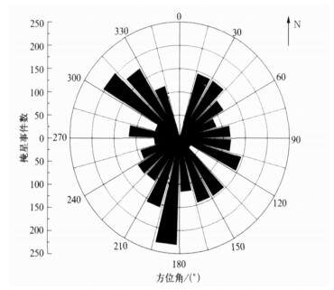
图 2 预报的雾灵山山基掩星事件发生数目随方位角分布
Fig. 2 Histogram of the predicted mountain-based occultation events occurring azimuth angles
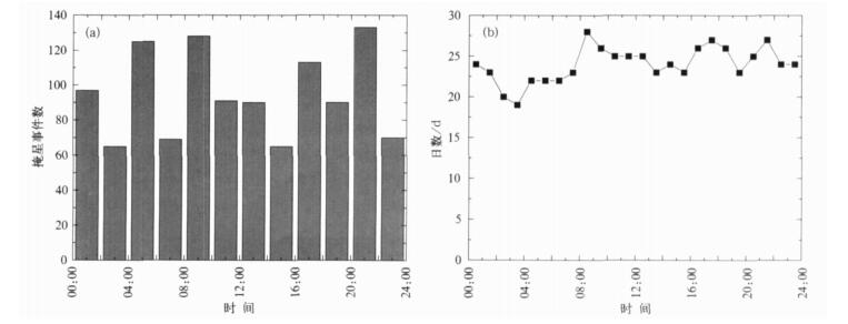
图 3 雾灵山观测山基掩星事件发生时间及观测天数分布 (a) 山基掩星事件发生时间分布直方图, (b) 每个小时接收机工作天数曲线
Fig. 3 Plot of the observed mountain-based occultation events occuring time and observing days (a) histogram of the observed mountain-based occultation events' occurring time, (b) the curve of observing days for each hour
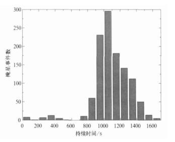
图 4 雾灵山观测山基掩星事件持续时间分布直方图
Fig. 4 Histogram of the observed mountain-based occultation events' duration

图 5 雾灵山观测山基掩星事件跟踪最低仰角分布直方图 (a) 山基掩星事件跟踪最低仰角分布直方图, (b) 上升掩星和下降掩星分别跟踪最低仰角分布直方图
Fig. 5 Histogram of the observed mountain-based occultation events minimum elevation (a) hisgogram of the obseved mountain-based occultation events minimum elevation, (b) histogram of the rising and setting occultation events minimun elevation
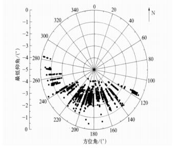
图 6 雾灵山观测山基掩星事件跟踪最低仰角随方位角分布散点图
Fig. 6 Scatter dot plot of minimum elevations versus azimuth angles
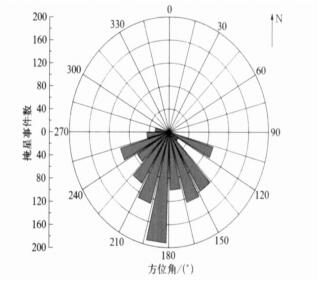
图 7 雾灵山观测山基掩星事件发生数目随方位角分布直方图
Fig. 7 Histogram of the observed mountain-based occultation events occurring azimuth angles
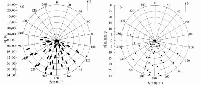
图 8 雾灵山观测山基掩星事件发生时间 (a) 及掩星卫星号随方位角分布散点图 (b)
Fig. 8 Scatter dot plot of occurring times (a) and GPS occultation number versus azimuth angles (b)
表 1 2005年8月1-29日每日观测掩星事件次数统计表
Table 1 The number of observed mountain-based occultation events during August 1—29, 2005

-
[1] Hajj G A, Romans L J. Ionospheric electron density profiles obtained with the global positioning system:Results from the GPS/MET Experiment. Radio Sciences, 1998, 33(1):175-190. doi: 10.1029/97RS03183 [2] Rius A, Ruffini G, Romeo A. Analysis of ionospheric electron density distribution from GPS/MET occultations. IEEE Trans, Geoscience and Remote Sensing, 1998, 36(2):383-394. doi: 10.1109/36.662724 [3] Ware R, Exner M, Feng D, et al. GPS sounding of the atmosphere from low earth orbit:Preliminary results. Bull Am Meteorol Soc, 1996, 77:19-40. doi: 10.1175/1520-0477(1996)077<0019:GSOTAF>2.0.CO;2 [4] Rocken C, Kuo Y H, Schreiner W, et al. COSMIC system description. TAO, 2000, 11(1):21-52. https://www.researchgate.net/publication/234422312_COSMIC_system_description [5] Kursinski E R, Hajj G A, Schofield J T, et al. Observing earth's atmosphere with radio occultation measurements using the Global Positioning System. J Geophys Res, 1997, 102(D19):23429-23465. doi: 10.1029/97JD01569 [6] Rocken C, Anthes R, Exner M, et al. Analysis and validation of GPS/MET data in the neutral atmosphere. J Geophys Res, 1997, 102(D25):29849-29866. doi: 10.1029/97JD02400 [7] Zuffada C, Hajj G, Kursinski E R. A novel approach to atmospheric profiling with a montain-based or airborne GPS receiver. J Geophys Res, 1999, 104(D20):24435-24447. doi: 10.1029/1999JD900766 [8] Aoyama Y, Shoji Y. Mountain top and Airborne GPS Observations, and Effects of Turbulence on RO Signals. Colloquium on Atmospheric Remote Sensing Using the Global Positioning System, Boulder, Colorado, June 20—July 2, 2004. [9] 胡雄, 张训械, 吴小成, 等.山基GPS掩星观测实验及其反演原理.地球物理学报, 2006, 49(1):22-27. http://www.cnki.com.cn/Article/CJFDTOTAL-DQWX200601004.htm [10] 曾桢.地球大气GPS无线电掩星观测技术研究.武汉:中国科学院研究生院, 2003. [11] 张训械, 曾桢, 胡雄, 等.山基无线电掩星模拟.电波科学学报, 2004, 19(5):530-536. http://www.cnki.com.cn/Article/CJFDTOTAL-DBKX200405004.htm [12] 何平, 徐宝祥, 周秀骥, 等.地基GPS反演大气水汽含量的初步试验.应用气象学报, 2002, 13(2):179-183. http://qikan.camscma.cn/jams/ch/reader/view_abstract.aspx?file_no=20020222&flag=1 [13] 谢璞, 张朝林, 王迎春, 等.北京地区单双频地基GPS大气水汽遥测试验与研究.应用气象学报, 2006, 17(增刊):28-33. http://www.cnki.com.cn/Article/CJFDTOTAL-YYQX2006S1003.htm [14] 胡雄, 曾桢, 张训械, 等.大气GPS掩星观测反演方法.地球物理学报, 2005, 48(4):768-774. http://www.cnki.com.cn/Article/CJFDTOTAL-DQWX200504005.htm [15] 严豪健, 郭鹏, 张贵霞, 等.上海天文台GPS掩星技术研究现状.中国科学院上海天文台年刊, 2003, 24:39-47. http://www.cnki.com.cn/Article/CJFDTOTAL-KXTW200300005.htm -

 下载:
下载:
 点击查看大图

计量
- 摘要浏览量: 3949
- HTML全文浏览量: 802
- PDF下载量: 1264
- 被引次数: 0
