
 设为首页
设为首页 加入收藏
加入收藏

Introduction and Evaluation of a Rainstorm-caused Flood Forecasting System
-
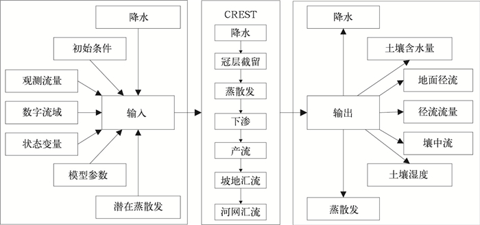
摘要: 该文研发了基于CREST V2.1分布式水文模型的暴雨致洪预报系统,应用中国气象局降水业务产品,开展全国0.125°×0.125°的逐日洪水预报和区域30"×30"的逐时洪水预报。其中,全国洪水预报以松花江、辽河、海河、黄河、淮河、长江、东南诸河、珠江、西南诸河和西北诸河十大水资源分区的典型流域为研究对象,区域洪水预报以淮河流域为研究对象。以模拟和观测流量之间的效率系数为目标函数,采用SCE-UA方法分别对全国和区域洪水预报模型的参数分流域进行率定。评估参数率定前后模型对效率系数、相关系数和相对偏差的改进程度,并对参数率定后的模型进行检验。结果表明:率定后的模型能够重现控制水文站的实测洪水过程,与率定前相比,效率系数和相对偏差有显著改进,相关系数有较大改进。系统符合业务需求,具有较好的预报精度和时效性,具备业务应用能力。Abstract: Flood disaster is one of the important factors that restrict the sustainable development of the economy and society of China. The development of a well-performing rainstorm-flood forecasting system is an important non-engineering flood prevention measure that would mitigate the loss of imminent flood disasters. A rainstorm-caused flood forecasting system, which is based on the distributed hydrological model CREST V2.1, is developed to provide refined streamflow, evapotranspiration, soil moisture, and other forecast products. By utilizing operational precipitation data from China Meteorological Administration (CMA) to serve as input for this system, nationwide flood forecasting is carried out by 0.125°×0.125° daily, and regional forecast is done by 30"×30" hourly. For the former, one typical watershed is selected for each of ten river basins as Songhua, Liao, Hai, Yellow, Huai, Yangtze, Southeast, Pearl, Southwest and Northwest River Basins, while for the latter just the Huai River Basin is taken as focus. The SCE-UA optimization algorithm is adopted to search the optimal parameter sets that maximize the Nash-Sutcliffe efficiency (E) between the observed and the simulated streamflow discharges for gauging stations of typical watersheds. E, correlation coefficient (C), and relative bias (B) are used to evaluate model performances before and after the calibration of model parameters. Validation tests are conducted by transferring calibrated parameter values to another flood event of the same watershed. Results show that the calibrated model can reproduce the observed flood processes and provide accurate hydrological forecasting service. Compared to the non-calibrated model, the calibrated one significantly improves E and B, and moderately improves C. It has good applicability in watersheds with different hydroclimatic, geological and geomorphological conditions, but has relatively weak forecasting ability for frequently fluctuating low-flow flood. For the model parameters, their values not only depend on the hydroclimatic, soil and vegetation conditions of the watersheds, but are also influenced by interactions among physical processes of the model. Besides, some empirical parameters need to be calibrated according to different levels of the flood events for the same watershed. Generally, this flood forecasting system show good forecasting accuracy and timeliness, which meets operational needs. However, further work is still needed to improve the prediction accuracy of the model. For example, the snowmelt module could be implemented into the CREST model to improve the prediction accuracy for flood disasters caused by snowmelt in the Northwest, Northeast, and Qinghai-Tibet Plateau regions. In addition, more observed streamflow discharge data should be collected to help calibrating model parameters for more watersheds. Furthermore, uncertainty quantification methods should be adopted to understand parameter behaviors, quantify and reduce parametric uncertainties.
-

图 4 全国0.125°×0.125°地理信息数据
(a)高程,(b)流向,(c)汇流累积量,(d)河网
Fig. 4 0.125°×0.125° geographic information data for China domain
(a)elevation, (b)flow direction, (c)flow accumulation, (d)stream network

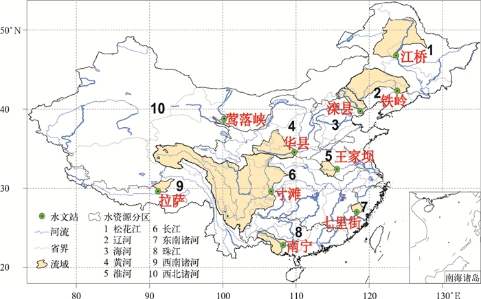
图 5 水文站率定期水文过程线
(a)江桥,(b)铁岭,(c)滦县,(d)华县,(e)王家坝,(f)寸滩,(g)七里街,(h)南宁,(i)拉萨,(j)莺落峡
Fig. 5 ydrographs for the calibration period at streamflow gauging stations
(a)Jiangqiao, (b)Tieling, (c)Luanxian, (d)Huaxian, (e)Wangjiaba, (f)Cuntan, (g)Qilijie, (h)Nanning, (i)Lhasa, (j)Yingluoxia

图 6 水文站检验期水文过程线
(a)江桥,(b)铁岭,(c)滦县,(d)华县,(e)王家坝,(f)寸滩,(g)七里街,(h)南宁,(i)拉萨,(j)莺落峡
Fig. 6 Hydrographs for the validation period at streamflow gauging stations
(a)Jiangqiao, (b)Tieling, (c)Luanxian, (d)Huaxian, (e)Wangjiaba, (f)Cuntan, (g)Qilijie, (h)Nanning, (i)Lhasa, (j)Yingluoxia
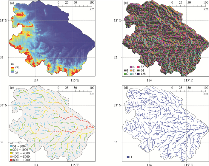
图 8 淮河流域30″×30″地理信息数据
(a)高程,(b)流向,(c)汇流累积量,(d)河网
Fig. 8 30″×30″ geographic information data for the Huai River Basin
(a)elevation, (b)flow direction, (c)flow accumulation, (d)stream network
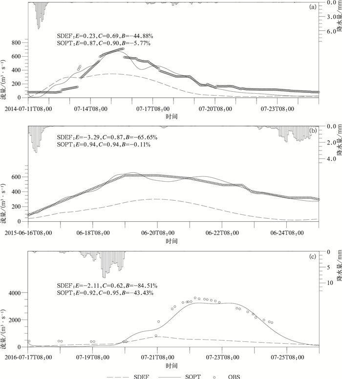
图 9 淮河流域王家坝站率定期水文过程线
(a)20140711号洪水,(b)20150616号洪水,(c)20160717号洪水
Fig. 9 Hydrographs at Wangjiaba Station of the Huai River Basin for the calibration period of flood events
(a)20140711, (b)20150616, (c)20160717
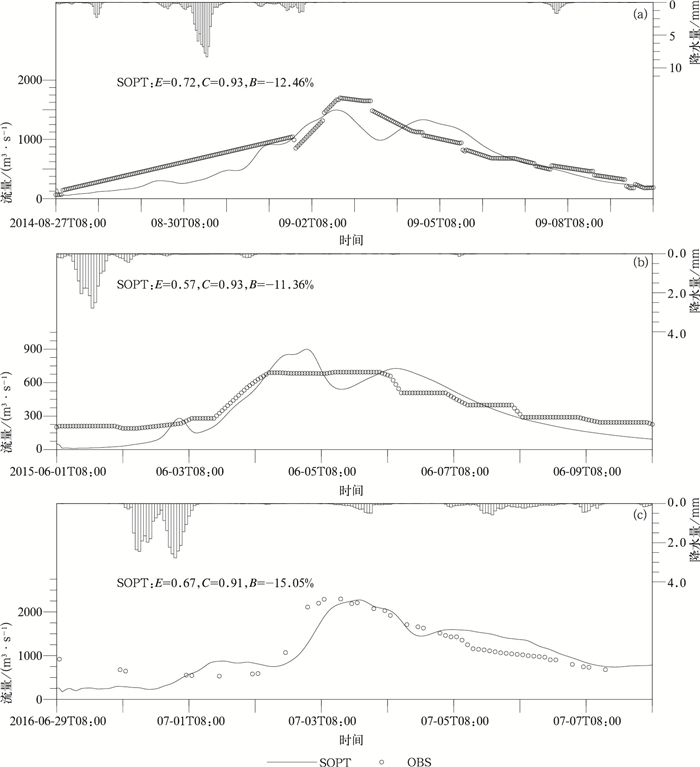
图 10 淮河流域王家坝站检验期水文过程线
(a)20140827号洪水,(b)20150601号洪水,(c)20160629号洪水
Fig. 10 Hydrographs at Wangjiaba Station of the Huai River Basin for the validation period of flood events
(a)20140827, (b)20150601, (c)20160629
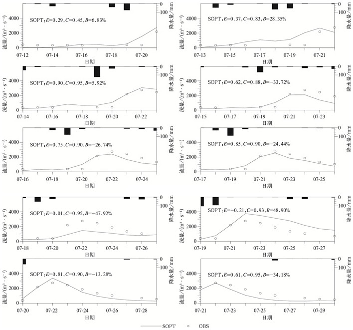
图 11 淮河流域王家坝站2016年7月12—21日未来10 d滚动预报水文过程线
Fig. 11 Hydrographs at Wangjiaba Station of the Huai River Basin for ten-day rolling forecast during the period from 12 Jul to 21 Jul in 2016
表 1 CREST模型参数及其取值范围
Table 1 CREST model parameters and their feasible ranges
参数 意义 默认值 最小值 最大值 RainFact 降水量转换系数 1.0 0.5 1.2 Ksat 土壤饱和导水率/(mm·d-1) 2.84 1 1000 WM 流域最大蓄水量/mm 129.95 1 500 B 下渗曲线指数 0.48 0.05 1.5 IM 不透水面积比 0.07 0 0.2 KE 潜在蒸散发转换系数 0.85 0.1 1.5 coeM 地面径流流速系数 58.89 1 150 expM 地面径流流速指数 0.25 0.1 2 coeR 地面径流流速转换为河道水流流速的转换因子 0.73 0.2 3 coeS 地面径流流速转换为壤中流流速的转换因子 0.63 0.001 1 KS 地面径流产流参数 0.41 0 1 KI 壤中流产流参数 0.22 0 1  下载: 导出CSV
-
[1] 任洪玉, 邹翔, 张平仓.我国山洪灾害成因分析.中国水利, 2007, 1(14):18-20. doi: 10.3969/j.issn.1000-1123.2007.14.010 [2] 李中平, 张明波.全国山洪灾害防治规划降雨区划研究.水资源研究, 2005, 26(2):32-34. http://cpfd.cnki.com.cn/Article/CPFDTOTAL-ZGSL200508001016.htm [3] 张庆云, 陶诗言, 彭京备.我国灾害性天气气候事件成因机理的研究进展.大气科学, 2008, 32(4):815-825. http://www.cnki.com.cn/Article/CJFDTOTAL-DQXK200804009.htm [4] 丁一汇.人类活动与全球气候变化及其对水资源的影响.中国水利, 2008, 2(8):20-27. http://www.cnki.com.cn/Article/CJFDTOTAL-SLZG200802008.htm [5] 王馥棠.近十年来我国气候变暖影响研究的若干进展.应用气象学报, 2002, 13(6):755-766. http://qikan.camscma.cn/jams/ch/reader/view_abstract.aspx?file_no=20020699&flag=1 [6] 王玉洁, 周波涛, 任玉玉, 等.全球气候变化对我国气候安全影响的思考.应用气象学报, 2016, 27(6):750-758. doi: 10.11898/1001-7313.20160612 [7] 孙建华, 赵思雄, 傅慎明, 等.2012年7月21日北京特大暴雨的多尺度特征.大气科学, 2013, 37(3):705-718. doi: 10.3878/j.issn.1006-9895.2013.12202 [8] 谌芸, 孙军, 徐珺, 等.北京721特大暴雨极端性分析及思考(一)观测分析及思考.气象, 2012, 38(10):1255-1266. doi: 10.7519/j.issn.1000-0526.2012.10.012 [9] 张顺利, 陶诗言, 张庆云, 等.1998年夏季中国暴雨洪涝灾害的气象水文特征.应用气象学报, 2001, 12(4):442-457. http://qikan.camscma.cn/jams/ch/reader/view_abstract.aspx?file_no=20010459&flag=1 [10] 周自江, 宋连春.1998年长江流域特大洪水的降水分析.应用气象学报, 2000, 11(3):287-296. http://qikan.camscma.cn/jams/ch/reader/view_abstract.aspx?file_no=20000344&flag=1 [11] 薛秋芳, 任传森, 陶诗言.1998年长江流域洪涝的成因分析.应用气象学报, 2001, 12(2):246-250. http://qikan.camscma.cn/jams/ch/reader/view_abstract.aspx?file_no=20010233&flag=1 [12] 国家防汛抗旱总指挥部.中国水旱灾害公报(2012).北京:中国水利水电出版社, 2013. [13] 李大鸣, 陈海舟, 范玉.国内外防洪减灾发展与现状.中国农村水利水电, 2005(9):33-37. http://www.cnki.com.cn/Article/CJFDTOTAL-ZNSD200509009.htm [14] 刘志雨.山洪预警预报技术研究与应用.中国防汛抗旱, 2012, 22(2):41-45. http://www.cnki.com.cn/Article/CJFDTOTAL-FHKH201202016.htm [15] 赵琳娜, 刘莹, 党皓飞, 等.集合数值预报在洪水预报中的应用进展.应用气象学报, 2014, 25(6):641-653. doi: 10.11898/1001-7313.20140601 [16] 王莉莉, 陈德辉, 赵琳娜.GRAPES气象-水文模式在一次洪水预报中的应用.应用气象学报, 2012, 23(3):274-284. http://qikan.camscma.cn/jams/ch/reader/view_abstract.aspx?file_no=20120303&flag=1 [17] 杨传国, 余钟波, 林朝晖.基于TRMM卫星雷达降雨的流域陆面水文过程.水科学进展, 2009, 20(4):461-466. http://www.cnki.com.cn/Article/CJFDTOTAL-SKXJ200904000.htm [18] Todini E.Hydrological catchment modelling:past, present and future.Hydrology and Earth System Sciences, 2007, 11(1):468-482, DOI: 10.5194/hess-11-468-2007. [19] Shen Y, Zhao P, Pan Y, et al.A high spatiotemporal gauge-satellite merged precipitation analysis over China.J Geophys Res, 2014, 119(6):3063-3075, DOI: 10.1002/2013JD020686. [20] 宇婧婧, 沈艳, 潘旸, 等.概率密度匹配法对中国区域卫星降水资料的改进.应用气象学报, 2013, 24(5):544-553. doi: 10.11898/1001-7313.20130504 [21] 潘旸, 沈艳, 宇婧婧, 等.基于贝叶斯融合方法的高分辨率地面-卫星-雷达三源降水融合试验.气象学报, 2015, 73(1):177-186. doi: 10.11676/qxxb2015.010 [22] Wang J, Hong Y, Li L, et al.The coupled routing and excess storage (CREST) distributed hydrological model.Hydrological Sciences Journal, 2011, 56(1):84-98, DOI: 10.1080/02626667.2010.543087. [23] Xue X, Hong Y, Zhang K.CREST-Coupled Routing and Excess Storage User Manual, Version 2.1.Norman, OK:University of Oklahoma, 2015. [24] Zhao R.The Xinanjiang model applied in China.Journal of Hydrology, 1992, 135(3):371-381, DOI: 10.1016/0022-1694(92)90096-E. [25] Xue X, Hong Y, Limaye A S, et al.Statistical and hydrological evaluation of TRMM-based multi-satellite precipitation analysis over the Wangchu Basin of Bhutan:Are the latest satellite precipitation products 3B42V7 ready for use in ungauged basins? J Hydrol, 2013, 499(13-14):91-99, DOI: 10.1016/j.jhydrol.2013.06.042. [26] Nash J E, Sutcliffe J V.River flow forecasting through conceptual models:Part Ⅰ-A discussion of principles.J Hydrol, 1970, 10(3):282-290, DOI: 10.1016/0022-1694(70)90255-6. [27] Duan Q, Sorooshian S, Gupta V.Effective and efficient global optimization for conceptual rainfall-runoff models.Water Resources Research, 1992, 28(4):1015-1031, DOI: 10.1029/91WR02985. [28] Taylor R.Interpretation of the correlation coefficient:a basic review.Journal of Diagnostic Medical Sonography, 1990, 6(1):35-39, DOI: 10.1177/875647939000600106. [29] Rothman A J, Klein W M, Weinstein N D.Absolute and relative biases in estimations of personal risk.Journal of Applied Social Psychology, 1996, 26(14):1213-1236, DOI: 10.1111/j.1559-1816.1996.tb01778.x. [30] Lehner B, Verdin K, Jarvis A.HydroSHEDS technical documentation, version 1.0.Washington, DC:World Wildlife Fund US, 2006. [31] Brown M E.Famine Early Warning Systems and Remote Sensing Data.Heidelberg:Springer-Verlag, 2008. [32] 刘昌明, 张丹.中国地表潜在蒸散发敏感性的时空变化特征分析.地理学报, 2011, 66(5):579-588. doi: 10.11821/xb201105001 -


 点击查看大图

计量
- 摘要浏览量: 4420
- HTML全文浏览量: 1291
- PDF下载量: 624
- 被引次数: 0
