
 设为首页
设为首页 加入收藏
加入收藏

Effects of Topographic Perturbation on the Precipitation Distribution in Sichuan
-
摘要: 引入一维加权平均的谱分析方法定量研究四川地形强迫对该区域降水分布的影响。结果表明:纬向地形和冬季降水谱峰锁相于同一波长(475.8 km),呈共振关系,地形与其他季节降水呈漂移关系,这与经向和纬向上环流变动有关,即冬季纬向环流占主导,纬向地形触发的大气波动对冬季降水策动作用大;夏季降水是各种不同尺度系统相互作用的结果,地形是重要因素之一。经向和纬向地形特征尺度分别为296.8 km和475.8 km,反映了地形强迫的中尺度特征,且纬向地形谱峰比经向大1个数量级,纬向强迫更明显。夏季降水谱峰比冬季大2个数量级,降水系统纬向特征尺度比冬季小约150 km,说明夏季在纬向地形强迫下,降水系统尺度减小的同时其强度大大增加,这在一定程度上可以解释中尺度对流性降水在夏季偏多。四川夏季最大降水位于雅安地区,其地形扰动比四川整体扰动更明显,故产生的降水也更大。夏季降水和经向地形锁相于同一波长(37.1 km),经向地形对雅安夏季强降水起关键作用。Abstract: Terrain characteristics can be accurately represented in spectrum space. Terrain spectra can quantitatively reflect effects of topographic dynamic forcing on the atmosphere. The one-dimensional weighted-average spatial spectral analysis method is used to explore topographic forcing on precipitation distribution in Sichuan. Results indicate that spectral distributions of terrain and winter precipitation in zonal direction present a typical resonance coupling pattern, while that of terrain and precipitation in other seasons drifts toward the smaller scale. In meridional direction, spectral distributions of terrain and precipitation in each season present the large-scale drift pattern. Different patterns are probably relevant to the change of circulations. In winter, due to strong zonal circulation and weak meridional circulation, atmospheric fluctuations caused by zonal topographic forcing show the most significant impact on precipitation. After that season, the zonal circulation weakens gradually in agreement with the decrease of zonal topographic forcing while the meridional flow enhances, leading to the increase of the damping of the zonal wind disturbance caused by terrain, and the pattern transforms from resonance to drift. Summer rainfall is produced by interaction among different scale systems, and terrain is one of the most important factors. The maximum topographic spectral energy in zonal direction is about an order of magnitude larger than that in meridional direction, implying that effects of topographic dynamic forcing are zonally stronger than that in meridional direction. Values of meridional and zonal topographic characteristic scales are 296.8 km and 475.8 km, respectively, which reflects the characteristic of the mesoscale topographic forcing coincident with the frequent mesoscale systems in Sichuan. The peak of the precipitation spectral energy in summer is about two orders of magnitude larger than that in winter and one order of magnitude larger than that in spring or autumn, and the characteristic scale in summer is about 150 km smaller than that in winter. It illustrates that the intensity of the zonal topographic dynamic forcing in summer is significantly increased when the scale of precipitation systems decreases, which explains the high frequency of mesoscale convective precipitation, and implies the significant impact of topographic dynamic forcing on atmosphere as well. The strongest summer precipitation in Sichuan is located at Ya'an, where larger-scale topographic perturbation is more significant than other region in Sichuan. The terrain spectra and summer precipitation spectra in meridional direction are phase-locked in identical wavelength (37.1 km), implying the critical role of terrain on the occurrence of heavy rainfall, and the effect of topographic dynamic forcing in meridional direction is dominant.
-
Key words:
- spectral analysis;
- weighted average;
- terrain spectra;
- characteristic scale
-
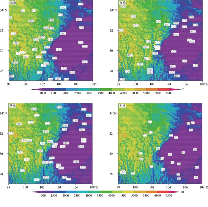
图 1 研究区域地形(填色)和年平均降水量(等值线,单位:mm)
Fig. 1 Distribution of topography(the shaded) and the climatological seasonal precipitation(the contour, unit:mm)
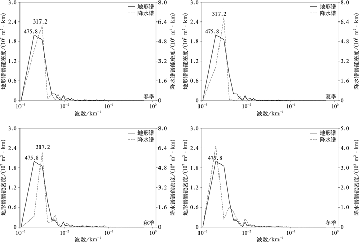
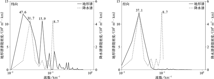
图 2 纬向地形谱和降水谱分布(图中数字表示谱峰的特征尺度,单位:km)
Fig. 2 Terrain spectra and precipitation spectra in zonal direction (numbers denote characteristic scales of peaks, unit:km)
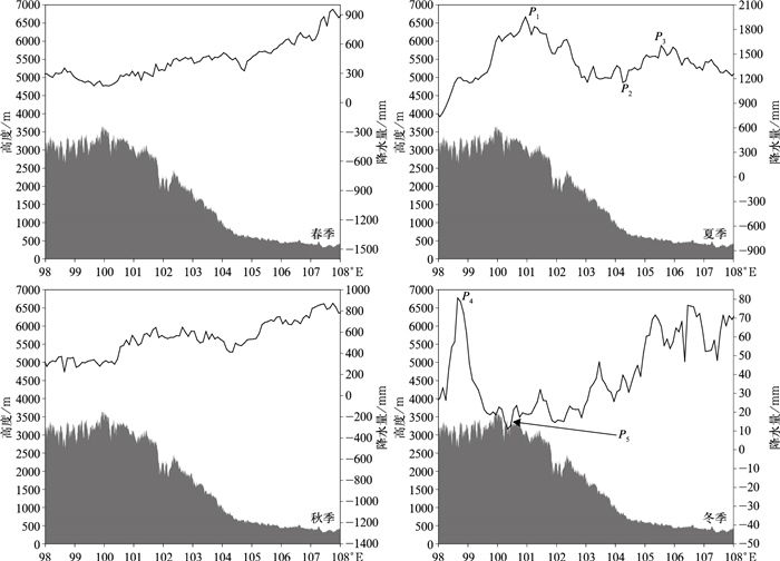
图 3 经向加权平均(27°~35°N)的纬向地形高度剖面(填色)和降水剖面(等值线)分布
(P1,P3,P4代表雨峰位置,P2,P5代表雨谷位置)
Fig. 3 Profile of topography(the shaded) and precipitation(the contour) in zonal direction by meridional weighted average(27°-35°N)
(P1, P3 and P4 denote the location of precipitation peaks; P2 and P5 denote the location of precipitation valleys)
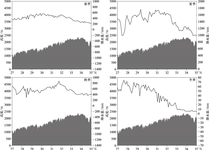
图 5 纬向加权平均(98°~108°E)的经向地形高度剖面(填色)和降水剖面(等值线)
Fig. 5 Profile of topography(the shaded) and precipitation(the contour) in meridional direction by zonal weighted average(98°-108°E)
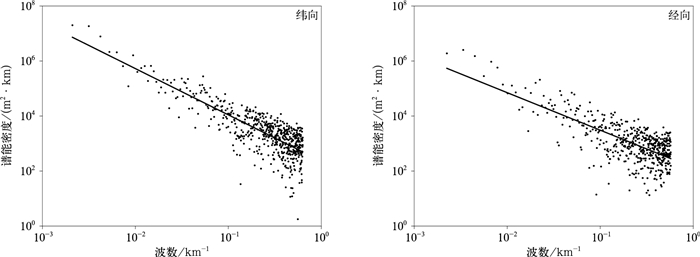
图 6 对数坐标下四川地区的纬向和经向地形谱能
Fig. 6 Distribution of zonal terrain spectra and meridional terrain spectra in Sichuan in log-log coordinate

图 7 对数坐标下雅安地区的纬向和经向地形谱能
Fig. 7 Distribution of zonal terrain spectra and meridional terrain spectra at Ya'an in log-log coordinate
-
[1] 张杰英.地形对大气环流影响的数值试验.应用气象学报, 1988(2):191-198. http://qikan.camscma.cn/jams/ch/reader/view_abstract.aspx?file_no=19880226&flag=1 [2] 钱永甫.包络地形和重力波拖曳对气候模拟效果的影响.应用气象学报, 2000, 11(1):13-20. doi: 10.3969/j.issn.1001-7313.2000.01.002 [3] 刘式适, 徐祥德.青藏高原大地形的动力、热力作用与低频振荡.应用气象学报, 2000, 11(3):312-321. doi: 10.3969/j.issn.1001-7313.2000.03.008 [4] 谌芸, 李强, 李泽椿.青藏高原东北部强降水天气过程的气候特征分析.应用气象学报, 2006, 17(增刊Ⅰ):98-103. http://d.old.wanfangdata.com.cn/Periodical/yyqxxb2006z1014 [5] 廖菲, 洪延超, 郑国光.地形对降水的影响研究概述.气象科技, 2007, 35(3):309-316. doi: 10.3969/j.issn.1671-6345.2007.03.001 [6] 楼小凤, 胡志晋, 王广河.对流云降水过程中地形作用的数值模拟.应用气象学报, 2001, 12, (增刊Ⅰ):113-121. http://www.wanfangdata.com.cn/details/detail.do?_type=perio&id=yyqxxb2001z1015 [7] 姜学恭, 沈建国, 刘景涛, 等.地形影响蒙古气旋发展的观测和模拟研究.应用气象学报, 2004, 15(5):601-611. doi: 10.3969/j.issn.1001-7313.2004.05.010 [8] Jiang Y J, Sang J G, Liu H Z, et al.Wave drag and form drag induced by small scale terrain in the nocturnal stable boundary layer.Chinese J Geophys, 2007, 50(1):43-50. [9] Steeneveld G J, Holtslag A A M, Nappo C J, et al.Exploring the possible role of small-scale terrain drag on stable boundary layers over land.J Appl Meteor Climatol, 2008, 47:2518-2530. doi: 10.1175/2008JAMC1816.1 [10] 梁胜华, 张灵, 千怀遂, 等.广东省北江流域坡向与海拔对汛期降水量的影响.应用气象学报, 2015, 26(3):338-345. http://qikan.camscma.cn/jams/ch/reader/view_abstract.aspx?file_no=20150309&flag=1 [11] 何立富, 陈涛, 孔期.华南暖区暴雨研究进展.应用气象学报, 2016, 27(5):559-569. http://qikan.camscma.cn/jams/ch/reader/view_abstract.aspx?file_no=20160505&flag=1 [12] 刘郁珏, 苗世光, 刘磊, 等.修正WRF次网格地形方案及其对风速模拟的影响.应用气象学报, 2019, 30(1):70-81. http://qikan.camscma.cn/jams/ch/reader/view_abstract.aspx?file_no=20190107&flag=1 [13] 郁淑华, 滕家谟, 何光碧.高原地形对四川盆地西部突发性暴雨影响的数值试验.大气科学, 1998, 22(3):379-383. doi: 10.3878/j.issn.1006-9895.1998.03.14 [14] 崔春光, 房春花, 胡伯威, 等.地形对低涡大暴雨影响的数值模拟试验.气象, 2000, 26(8):14-18. doi: 10.3969/j.issn.1000-0526.2000.08.004 [15] 赵玉春, 许小峰, 崔春光.川西高原东坡地形对流暴雨的研究.气候与环境研究, 2012, 17(5):607-616. http://www.wanfangdata.com.cn/details/detail.do?_type=perio&id=qhyhjyj201205010 [16] 段静鑫, 赵天良, 徐祥德, 等.四川暴雨过程中盆地地形作用的数值模拟.应用气象学报, 2018, 29(3):307-320. http://qikan.camscma.cn/jams/ch/reader/view_abstract.aspx?file_no=20180305&flag=1 [17] 黄瑶, 肖天贵, 金荣花.大气低频振荡对四川盆地持续性强降水的影响.应用气象学报, 2019, 30(1):93-104. http://qikan.camscma.cn/jams/ch/reader/view_abstract.aspx?file_no=20190109&flag=1 [18] Scorer R S.Theory of waves in the lee of mountains.Q J R Meteorol Soc, 1949, 75:41-56. doi: 10.1002/qj.49707532308 [19] 巢纪平, 章光锟, 袁孝明.二层模式中小地形对于气压跳跃形成的初步研究.气象学报, 1964, 34(2):109-117. [20] Mclntyre M E.On Long's hypothesis of no upstream influence in uniformly stratified or rotating flow.Journal of Fluid Mechanics, 1972, 52(2):209-243. doi: 10.1017/S0022112072001387 [21] Long R R.Some aspects of the flow of stratified fluids. Ⅰ:A theoretical investigation.Tellus, 1953, 5:42-58. [22] Scorer R S, Klieforth H.Theory of mountain waves of large amplitude.Q J R Meteorol Soc, 1959, 85:131-143. doi: 10.1002/qj.49708536406 [23] Pielke R A, Kennedy E.Mesoscale Terrain Features.Rep UVA-ENV SCI-MESO, 1980, 1(1):1-15. [24] Young G S, Pielke R A.Application of terrain height variance spectra to mesoscale modeling.J Atmos Sci, 1983, 40:2555-2560. doi: 10.1175/1520-0469(1983)040<2555:AOTHVS>2.0.CO;2 [25] Young G S, Pielke R A, Kessler R C.A comparison of the terrain height variance spectra of the Front Range with that of a hypothetical mountain.J Atmos Sci, 1984, 41(7):1249-1252. doi: 10.1175/1520-0469(1984)041<1249:ACOTTH>2.0.CO;2 [26] Srinivasan K, Ramanathan N.Terrain variance spectra for Indian Western Ghats.Proc Indian natn Sci Acad, 1994, 60A:133-138. [27] Ramanathan N, Srinivasan K.An estimation of optimum grid size for Kashmir Valley by spectral method.J Appl Meteor, 1995, 34(12):2783-2786. doi: 10.1175/1520-0450(1995)034<2783:AEOOGS>2.0.CO;2 [28] 王宛亭, 王元.卫星遥测纬向剖面地形谱分析——青藏高原背风侧地区地形扰动与西风扰动的耦合模态.南京大学学报(自然科学版), 2004, 40(3):304-318. doi: 10.3321/j.issn:0469-5097.2004.03.005 [29] 舒守娟, 王元, 李艳.西藏高原地形扰动对其降水分布影响的研究.水科学进展.2006, 17(5):585-591. doi: 10.3321/j.issn:1001-6791.2006.05.001 [30] 潘旸, 沈艳, 宇婧婧, 等.基于最优插值方法分析的中国区域地面观测与卫星反演逐时降水融合试验.气象学报, 2012, 70(6):1381-1389. http://www.wanfangdata.com.cn/details/detail.do?_type=perio&id=qxxb201206018 [31] 陈于湘.夏季西太平洋越赤道气流的谱分析.大气科学, 1980, 4(4):363-368. doi: 10.3878/j.issn.1006-9895.1980.04.10 [32] Trenberth K E, Solomon A.Implications of global atmospheric spatial spectra for processing and displaying data.J Climate, 1993, 6:531-545. doi: 10.1175/1520-0442(1993)006<0531:IOGASS>2.0.CO;2 [33] 郑永骏, 金之雁, 陈德辉.半隐式半拉格朗日动力框架的动能谱分析.2008, 66(2): 143-157. http://www.cnki.com.cn/Article/CJFDTotal-QXXB200802001.htm [34] Hsu H M, Moncrieff M W, Tung W W, et al.Multiscale temporal variability of warm-season precipitation over North America:statistical analysis of radar measurements.J Atmos Sci, 2006, 63:2355-2368. doi: 10.1175/JAS3752.1 [35] 叶笃正, 曾庆存, 郭裕福.当代气候研究.北京:气象出版社, 1991. [36] Pielke R A.Mesoscale Meteorological Modeling.San Diego:Academic Press, 1984. http://d.old.wanfangdata.com.cn/Periodical/qx201101005 [37] Yoshino M M.Climate in a Small Area.Tokyo:University of Tokyo Press, 1975. [38] 王明华, 杜继稳.秦岭山脉与陕西降水//山地气候文集编委会.山地气候文集.北京: 气象出版社, 1984. [39] 傅抱璞.山地气候.北京:科学出版社, 1983. [40] 林之光.地形降水气候学.北京:科学出版社, 1995. [41] Bretherton F P.Momentum transport by gravity waves.Q J R Meteorol Soc, 1969, 95:213-243. doi: 10.1002/qj.49709540402 [42] Salvador R, Calbo J, Millan M M.Horizontal grid size selection and its influence on mesoscale model simulations.J Appl Meteor, 1999, 38:1311-1329. doi: 10.1175/1520-0450(1999)038<1311:HGSSAI>2.0.CO;2 -

 下载:
下载:

 点击查看大图
计量
- 摘要浏览量: 5261
- HTML全文浏览量: 2106
- PDF下载量: 126
- 被引次数: 0
