用多普勒雷达反射率调整模式大气的云微物理变量
MICROPHYSICAL ADJUSTMENTS USING REFLECTIVITY OF DOPPLER RADAR FOR MESO-SCALE MODEL
-
摘要: 一种简单云分析方案, 用于由多普勒天气雷达反射率反演中尺度大气模式初值分析中的云微物理变量(云水混合比和雨水混合比)和空气湿度变量(比湿),使模式积分初始场反映出观测空间的云微物理特征以及哪些空间位置上的大气处于饱和状态。应用于2002年6月梅雨期安徽省马鞍山市一次降水过程的临近数值预报试验结果表明,模式预报的大气综合反射率与雷达观测的回波图像相近,由云微物理变量变化表示的模式云系演变与雷达观测的回波图像一致, 伴随模拟的中小尺度云系, 模式大气能很快调整出合理的中小尺度流场辐散、辐合结构;它们明显好于模式初始场不引入雷达反射率时的结果,即这种方法对改进临近数值天气预报准确率是有效的。Abstract: A simple analysis scheme proposed by Brewster K in 1996 is used to retrieve cloud microphysical variables such as water mixing ratio and rainwater mixing ratio of cloud, as well as humility variable of the model air from Doppler weather radar's reflectivity. The initial fields of meso-scale numerical model derived from model's data assimilation system can include cloud microphysical messages and show where the air is saturated within model space. A numerical experiment for a rainfall process near Maanshan City of Anhui Province in China on June 19 of 2002 is performed by the Advanced Regional Prediction System (ARPS) based on this scheme. The background fields and boundary conditions come from the globe model's output of AVN in NCEP, and a 600 km×600km domain is setup with 2km×2km horizontal resolution, and 21 layers in vertical. Results show that 1 hour's forecast of the atmospheric composite reflectivity with ARPS matches the detailed echo picture observed by the radar at target time, and the non-uniform distribution of precipitation with some rainfall clusters matches the non-uniform distribution of echoes with several strong clusters. The clouds represented by cloud microphysical variables can be tracked both in horizontal and vertical directions from initial time to the time of forecast, and their changes are consistent with the observed radar reflectivity. Also some of the meso-scale wind structures with convergence and divergence appear near the strong echoes, which result from atmosphere thermodynamic adjustment to the clouds. Comparatively, the forecast doesn't match the observation if not considering such scheme including radar reflectivity within data assimilation system for initial field of the model. So it seems that this analysis scheme used here would be helpful for numerical nowcasting of the precipitation.
-
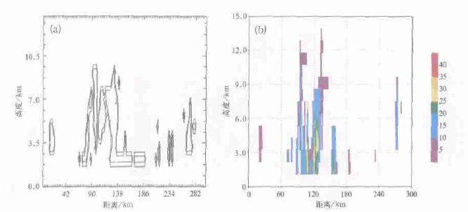
图 3 沿图 2(a)中AB垂直剖面上反演的qc(a)(单位:g·kg-1,等值线间隔为0.4g·kg-1)(a) 和观测的反射率 (单位:dBz)(b)
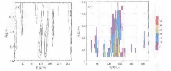
图 5 模式积分1 h时沿图 2(a)中AB垂直剖面上反演的qr(a)(单位:g·kg-1,等值线间隔为0.4g·kg-1)(a) 和观测的反射率 (单位:dBz)(b)
-
[1] Sun J, Flicher D, Lilly D. Recovery of three-dimensional wind and temperature fields from single-Doppler radar data. JAtmos Sci, 1991, 48: 876~890. doi: 10.1175/1520-0469(1991)048<0876:ROTDWA>2.0.CO;2 [2] Qiu C J, Xu Q. Least-square retrieval of microburst winds from single-Doppler radar data. Mon Wea Rev, 1996, 124:1132~1144. doi: 10.1175/1520-0493(1996)124<1132:LSROMW>2.0.CO;2 [3] Laroche S, Zawadzki I. A variational analysis method for retrieval of three-dimensional wind field from single Doppler radar data. J Atmos Sci, 1994, 51: 2664~2682. doi: 10.1175/1520-0469(1994)051<2664:AVAMFR>2.0.CO;2 [4] Brewster K. Correcting assimilation of radar for thunderstorm forecasting. Preprints. 12th Conference on Numerical Weather Prediction, Phoenix, AZ, AMS, Boston, 1998.181~184. [5] Brewster K. Application of a Bratserth analysis scheme including Doppler radar data. 15th Conference on Weather Analysis and Forecasting. American Meteorological Society, Norfolk, VA, 1996.92~95. [6] 刘黎平.用双多普勒雷达反演降水系统三维风场试验研究.应用气象学报, 2003, 14(4):502~506. http://qikan.camscma.cn/jams/ch/reader/view_abstract.aspx?file_no=20070352&flag=1 [7] 邱崇践, 余金香.多普勒雷达资料对中尺度系统短期预报的改进.气象学报, 2000, 58(2):244~249. http://www.cnki.com.cn/Article/CJFDTOTAL-QXXB200002011.htm [8] Xue M, Droegemeier K K, Wang V, et al. ARPS Version 4.0 User's Guide. Center for Analysis and Prediction of Storms, University of Oklahoma, 1995. [9] 马清云, 李泽椿, 陶士伟.单部多普勒天气雷达风场反演及其在数值预报中的应用试验.应用气象学报, 2001, 12(4):488~494. http://qikan.camscma.cn/jams/ch/reader/view_abstract.aspx?file_no=20010463&flag=1 [10] Xue M, Droegemeier K K, Wong V. The Advanced Regional Prediction System (ARPS)-A multscale nonhydrostatic atmospheric simulation and prediction tool, Part Ⅱ:Model physics and applications. Meteor Atmos Physics, 2001, 76:134~165. [11] Li Y P, Xue H J, Bane J. Air-sea interactions during the passage of a winter storm over the Gulf Stream: A 3D coupled Atmosphere-Ocean model study. J Geophys Res, 2002, 107 (C11): 3200, doi: 10.1029/2001JC001161. -


 设为首页
设为首页 加入收藏
加入收藏


 下载:
下载:
