对流天气临近预报技术的发展与研究进展
A BRIEF REVIEWON THE DEVELOPMENT OF NOWCASTING FOR CONVECTIVE STORMS
-
摘要: 目前,临近预报技术主要包括雷暴识别追踪和外推预报技术、数值预报技术以及以分析观测资料为主的概念模型预报技术等。其中,识别追踪和外推预报技术主要以雷达资料为基础,在这方面,交叉相关外推和回波特征追踪识别外推是比较成熟的技术,已经用于许多的临近预报业务系统中,其缺陷是预报时效较短,准确率也不是很高。随着精细数值天气预报技术和计算机技术的发展,利用多普勒天气雷达资料和其它中小尺度观测资料进行数值模式初始化,来预报雷暴的发生、发展和消亡已经成为一个研究的热点,该技术发展很快但还不成熟。概念模型预报技术主要是通过综合分析多种中小尺度观测资料,包括雷达和气象卫星资料等,在此基础上建立雷暴发生、发展和消亡的概念模型,特别是边界层辐合线和强对流的密切关系等,再结合数值模式分析预报和其它外推技术的结果,然后建立雷暴临近预报的专家系统,其不但可以获取雷暴和对流降水移动、发展的信息,还可以预报它们的生成和消亡。检验和定性评估也表明,将多种资料和技术集于一体的概念模型专家系统,其临近预报的准确率最高,时效也最长,是临近预报技术未来发展的主要趋势之一。NCAR的Auto Nowcaster系统是雷暴临近预报概念模型专家系统的一个典型代表。Abstract: Nowadays, the nowcasting technique and research for convective storms have an exciting advancement along with the rapid development of Doppler weather radar and many else meso-and micro-scale meteorological observation instruments. At present, main nowcasting techniques comprise three aspects: identification, tracking and extrapolation forecast, numerical model forecast, knowledge-based forecast technique. Cross-correlation technique and echo feature identification and algorithms are well-performed extrapolation techniques mainly based on weather radar data and are utilized by many operational nowcasting systems, but there are very short forecast period and low accuracy. Now the techniques that assimilate radar, mesonet and micro-scale data into fine meso-and micro-scale numerical models to nowcast initiation, evolution and dissipation of thunderstorms are very promising and robust. Techniques are progressing rapidly but not mature for operation. Knowledge-based nowcasting techniques are more observation-based. They combine and analyze a variety of fine meteorological data sources, including radar and satellite data, then theorize conceptual models of initiation, evolution and dissipation of thunderstorms, especially, the close relation between boundary layer convergence lines and enhanced convection, as well as integrate fine numerical models outputs initiated with or without radar data and extrapolation technique results, then build expert system of thunderstorm nowcasting to gain information about not only the development but also the initiation and dissipation of thunderstorms and convective rainfall. Verification and qualitative assessment of forecast also show that the expert systems outperform all other techniques for operational nowcasting thunderstorms and convective precipitation in accuracy and period. The expert systems are one of the primary techniques for nowcasting convective storms evolution in the near future. Auto-Nowcaster developed by NCAR is one of the state-of-the-art expert systems for nowcasting thunderstorms.
-
Key words:
- Nowcasting;
- Algorithm;
- Expert system
-
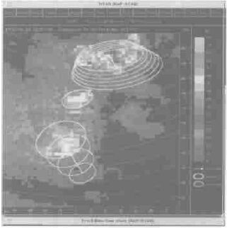
图 2 TITAN对风暴单体追踪的一个例子[19]
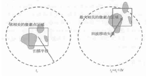
图 3 使用交叉相关法对一定反射率阈值之上的区域追踪的例子[20]
(图中箭头给出了雷达反演的风场信息)
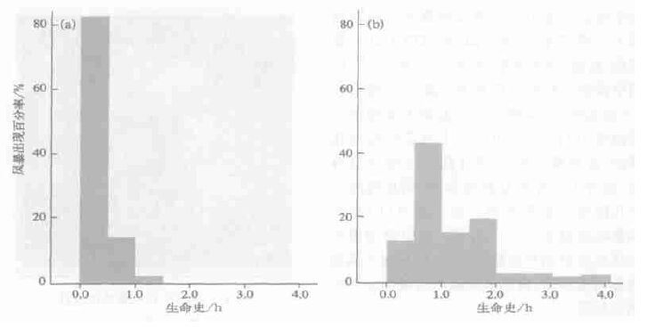
图 4 由TITAN系统获得的单体风暴 (a) 和多单体及超级单体风暴 (b) 个例的生命史统计结果[23]
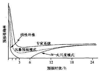
图 6 各种预报方法对风暴临近预报准确性的定性评估[19]
(假定各种方法预报的空间尺度均可达几公里)
表 1 几种方法对风暴发生和消亡30 min临近预报的检验[19]

-
[1] Crum T D, Alberty R L. The WSR-88D and the WSR-88D operational support facilities. Bull Amer Meteor Soc, 1993, 74: 250~262. https://www.researchgate.net/publication/234272641_The_WSR-88D_and_the_WSR-88D_operational_support_facility [2] WSR-88D Operation Course. WSR-88D Operational Training Branch, Norman, Oklahoma, 1996. [3] Basic Principles of the NEXTRAD WSR-88D Doppler Weather Radar. NEXTRAD/Operational Support Facility-Operations Training Branch, Norman, Oklahoma, 1998. [4] Keenan T, Wilson J, Joe P, et al. The World Weather Research Program (WWRP) Sydney 2000 Forecast Demonstration Project: Overview. Preprints 30th International Conference on Radar Meteorology, Munich, Germany, 2001. [5] Keenan T, Joe P, Wilson J, et al. The Sydney 2000 World Weather Research Program Forecast Demonstration Project:Overview and Current Status. Bull Amer Meteor Soc, 2003, 84: 1041~1054. doi: 10.1175/BAMS-84-8-1041 [6] Linda Anderson-Berry, Keenan T, Bally J, et al. The Societal, Social, and Economic Impacts of the World Weather Research Programme Sydney 2000 Forecast Demonstration Project (WWRP S2000 FDP). Weather and Forecasting, 2004, 19: 168~178. doi: 10.1175/1520-0434(2004)019<0168:TSSAEI>2.0.CO;2 [7] 俞小鼎, 姚秀萍, 熊廷南, 等. 新一代天气雷达讲义 (试用). 中国气象局培训中心, 2000. [8] 葛润生. 新一代天气雷达系统讲座. 新一代天气雷达系统建设管理干部培训班讲义汇编. 中国气象局培训中心, 2000. [9] Rinehart R E, Garvey E T. Three-dimensional storm motion detection by conventional weather radar. Nature, 1978, 273: 287~289. doi: 10.1038/273287a0 [10] Austin G L, Bellon A. The use of digital weather radar records for short-term precipitation forecasting. Quart J Roy Meteorol Soc, 1974, 100: 658~664. doi: 10.1002/(ISSN)1477-870X [11] Browning K A, Collier C G, Larke P R, et al. On the forecasting of frontal rain using a weather radar network. Mon Wea Rev, 1982, 110: 534~552. doi: 10.1175/1520-0493(1982)110<0534:OTFOFR>2.0.CO;2 [12] Li P W, Wong W K, Chan K Y, et al. SWIRLS An Evolving Nowcasting System. Technical Note, No. 100.Hong Kong Observatory, 2000. [13] Li L, Schmid W, Joss J. Nowcasting of motion and growth of precipitation with radar over a complex orography. J Appl Meteor, 1995, 34: 1286~1300. doi: 10.1175/1520-0450(1995)034<1286:NOMAGO>2.0.CO;2 [14] Einfalt T, Denoeux T, Jaquet G. A radar rainfall forecasting method designed for hydrological purposes. J Hydrol, 1990, 114: 229~244. doi: 10.1016/0022-1694(90)90058-6 [15] Wolf D E, Hall D J, Endlich R M. Experiment in automatic cloud tracking using SMS-GOES data. J Appl Meteor, 1977, 16: 1219~1230. doi: 10.1175/1520-0450(1977)016<1219:EIACTU>2.0.CO;2 [16] Johnson J T, MacKeen P L, Witt A, et al. The storm cell identification and tracking algorithm: an enhanced WSR-88D algorithm. Weather and Forecasting, 1998, 13: 263~276. doi: 10.1175/1520-0434(1998)013<0263:TSCIAT>2.0.CO;2 [17] Dixon M, Wiener G. TITAN: Thunderstorm Identification, Tracking, Analysis, and Nowcasting--A Radar-based Methodology. J Atmos Ocean Tech, 1993, 10: 785~797. doi: 10.1175/1520-0426(1993)010<0785:TTITAA>2.0.CO;2 [18] Dixon M, 徐传玉.利用雷达进行风暴的识别, 跟踪, 分析和临近预报的方法.气象科技, 1994, 4:39~45. http://mall.cnki.net/magazine/Article/QXKJ404.006.htm [19] Wilson J W, Crook N A, Mueller C K, et al. Nowcasting tunderstorm: A status report. Bull Amer Meteor Soc, 1998, 79:2079~2099. doi: 10.1175/1520-0477(1998)079<2079:NTASR>2.0.CO;2 [20] Wilson J W, Pierce C, Seed A, et al. Sydney 2000 Field Demonstration Project--Convective Storm Nowcasting.Preprints 30th International Conference on Radar Meteorology. Munich, Germany, 2001. [21] Battan L J. Duration of convective radar cloud units. Bull Amer Meteor Soc, 1953, 34: 227~228. https://www.researchgate.net/profile/Daniel_Martinez-Castro/publication/265742684_RADAR_TRACKING_METHOD_FOR_CLOUD_SEEDING_EXPERIMENTAL_UNITS_OVER_CUBA/links/55e5b2de08aebdc0f58b2630.pdf?inViewer=true&disableCoverPage=true&origin=publication_detail [22] Foote G B, Mohr C G. Results of a randomized hail suppression experiment in northeast Colorado. Part Ⅵ: Post hoc stratification by storm type and intensity. J Appl Meteor, 1979, 18: 1589~1600. doi: 10.1175/1520-0450(1979)018<1589:ROARHS>2.0.CO;2 [23] Henry S G. Analysis of Thunderstorm Lifetime as a Function of Size and Intensity. Preprints 26th Conf on Radar Meteorology. Norman, OK: Amer Meteor Soc, 1993. 138~140. [24] Thorpe A J, Miller M J, Moncrieff M W. Two-dimensional convection in nonconstant shear: A model of mid-latitude squall lines. Quart J Roy Meteorl Soc, 1982, 108: 739~762. doi: 10.1002/(ISSN)1477-870X [25] Rotunno R J, Klemp J B, Weisman M L. A theory for strong, long-lived squall lines. J Atmos Sci, 1988, 45: 463~485. doi: 10.1175/1520-0469(1988)045<0463:ATFSLL>2.0.CO;2 [26] Weisman M L, Klemp J B, Rotunno R J. Structure and evolution of numerically simulated squall lines. J Atmos Sci, 1988, 45:1990~2013. doi: 10.1175/1520-0469(1988)045<1990:SAEONS>2.0.CO;2 [27] Carbone R G, Coauthors. Convective dynamics: Panel report. Radar in Meteorology, Amer Meteor Soc, 1990, 391-400. [28] Hane C E, Bluestein H B, Crawford T M, et al. Severe thunderstorm development in relation to along-dryline variability: A case study. Mon Wea Rev, 1997, 125: 231~251. doi: 10.1175/1520-0493(1997)125<0231:STDIRT>2.0.CO;2 [29] Mueller C K, Wilson J W, Crook N A. The utility of sounding and mesonet data to nowcast thunderstorm initiation.Weather and Forecasting, 1993, 8: 132~146. doi: 10.1175/1520-0434(1993)008<0132:TUOSAM>2.0.CO;2 [30] Weckwerth T M, Wilson J W, Wakimoto R M. Thermodynamic variability within the convective boundary layer due to horizontal convective rolls. Mon Wea Rev, 1996, 124: 769~784. doi: 10.1175/1520-0493(1996)124<0769:TVWTCB>2.0.CO;2 [31] 张群, 张维恒, 姜勇强.边界层辐合线发展成飑线的数值实验.气象科学, 2001, 21(3):308~315. http://www.cnki.com.cn/Article/CJFDTOTAL-QXKX200103006.htm [32] Wilson J W, Schreiber W E. Initiation of convective storms by radar-observed boundary layer convergence lines. Mon Wea Rev, 1986, 114: 2516~2536. doi: 10.1175/1520-0493(1986)114<2516:IOCSAR>2.0.CO;2 [33] Wilson J W, Foote G B, Fankhauser J C, et al. The role of boundary layer convergence zones and horizontal rolls in the initiation of thunderstorms: a case study. Mon Wea Rev, 1992, 120: 1758~1815. https://www.researchgate.net/publication/249620553_The_Role_of_Boundary-Layer_Convergence_Zones_and_Horizontal_Rolls_in_the_Initiation_of_Thunderstorms_A_Case_Study [34] Wilson J W, Mueller C K. Nowcast of thunderstorm initiation and evolution. Weather and Forecasting, 1993, 8:113~131. doi: 10.1175/1520-0434(1993)008<0113:NOTIAE>2.0.CO;2 [35] Wilson J W, Megenhardt D L. Thunderstorm initiation, organization and lifetime associated with Florida boundary layer convergence lines. Mon Wea Rev, 1997, 125: 1507~1525. doi: 10.1175/1520-0493(1997)125<1507:TIOALA>2.0.CO;2 [36] Wilson J W, Roberts R, Mueller C. Sydney 2000 Forecast Demonstration Project: Convective Storm Nowcasting.Weather and Forecasting, 2004, 19: 131~150. doi: 10.1175/1520-0434(2004)019<0131:SFDPCS>2.0.CO;2 [37] MuellerC, SaxenT, RobertsR, etal. NCAR Auto-Nowcast System. WeatherandForecasting, 2003, 18: 545~561. https://www.deepdyve.com/lp/american-meteorological-society/ncar-auto-nowcast-system-f65mFePMax [38] Sun J, Crook N A. Dynamical and microphysical retrieval from Doppler radar observations using a cloud model and its adjoint: Part Ⅰ: Model development and simulated data experiments. J Atmos Sci, 1997, 54:1642~1661. doi: 10.1175/1520-0469(1997)054<1642:DAMRFD>2.0.CO;2 [39] Sun J, Crook N A. Dynamical and microphysical retrieval from Doppler radar observations using a cloud model and its adjoint: Part Ⅱ: Retrieval experiments of an observed Florida convective storm. J Atmos Sci, 1998, 55: 835~852. doi: 10.1175/1520-0469(1998)055<0835:DAMRFD>2.0.CO;2 [40] Pierce C E, Collier C G, Hardaker P J, et al. GANDOLF: a system for generating automated nowcasts of convective precipitation. Met A pps, 2000, 7 : 341~360. doi: 10.1017/S135048270000164X/references?rft_val_fmt=info%3Aofi%2Ffmt%3Akev%3Amtx%3Abook&rft.btitle=FRONTIER%27%20Evaluation%20of%20Radar%E2%80%90Based%20Rainfall%20and%20River%20Flow%20Forecasts%2C%20April%201992%20to%20March%201993&rft.spage=122&rft.date=1993 [41] 王笑芳, 丁一汇.北京地区强对流天气短时预报方法的研究.大气科学, 1994, 18(2):173~183. http://www.cnki.com.cn/Article/CJFDTOTAL-DQXK199402004.htm [42] 杜秉玉, 姚祖庆.上海地区强对流天气短时预报系统.南京气象学院学报, 2000, 23(2):242~250. http://www.cnki.com.cn/Article/CJFDTOTAL-NJQX200002012.htm [43] Hemler R S, Lipps F B, Ross B B. A simulation of a squall line using a nonhydrostatic cloud model with a 5 km horizontal grid. Mon Wea Rev, 1991, 119: 3012~3033. doi: 10.1175/1520-0493(1991)119<3012:ASOASL>2.0.CO;2 [44] Zhang D L, Gao K, Parsons D B. Numerical simulation of an intense squall line during 10-11 June 1985 PreSTORM.Part Ⅰ: Model verification. Mon Wea Rev, 1989, 117: 960~994. doi: 10.1175/1520-0493(1989)117<0960:NSOAIS>2.0.CO;2 [45] 张沛源, 周海光, 胡绍萍.双多普勒天气雷达风场探测的可靠性研究.应用气象学报, 2002, 13(4):485~496. http://qikan.camscma.cn/jams/ch/reader/view_abstract.aspx?file_no=20020464&flag=1 [46] 周海光, 张沛源.笛卡儿坐标系的双多普勒天气雷达三维风场反演技术.气象学报, 2002, 60(5):585~593. http://www.cnki.com.cn/Article/CJFDTOTAL-QXXB200205008.htm [47] Sleigh M W, Fox N I, Collier C G, et al. The Performance of the GANDOLF Nowcasting System during the Sydney 2000 Forecast Demonstration Project. Preprints 30th International Conference on Radar Meteorology. Munich, Germany, 2001. [48] Sun J, Crook N A. Real-time low-level wind and temperature analysis using WSR-88D data. Weather and Forecasting, 2001, 16:117~132. doi: 10.1175/1520-0434(2001)016<0117:RTLLWA>2.0.CO;2 [49] Crook N A, Sun J. Assimilating radar, surface and profiler data for the Sydney 2000 Forecast Demonstration Project.Preprints 30th International Conference on Radar Meteorology. Munich, Germany, 2001. [50] Donaldson N, Pierce C, Sleigh M, et al. Comparison of Forecasts of Widespread Precipitation during the Sydney 2000Forecast Project. Preprints 30th International Conference on Radar Meteorology. Munich, Germany, 2001. [51] Brown B, Bally J, Brooks H, et al. Forecast Verification Activities for the Sydney 2000 Forecast Demonstration Project. Preprints 30th International Conference on Radar Meteorology. Munich, Germany, 2001. [52] Elizabeth E, Laurence J, Barbara G, et al. Verification of Nowcasts from the WWRP Sydney 2000 Forecast Demonstration Project. Weather and Forecasting, 2004, 19: 73~96. doi: 10.1175/1520-0434(2004)019<0073:VONFTW>2.0.CO;2 -


 设为首页
设为首页 加入收藏
加入收藏


 下载:
下载:
