1999—2003年西北太平洋热带气旋综合预报的误差分析
Error Analysis on Tropical Cyclone Official Forecast in the Northwest Pacific from 1999 to 2003
-
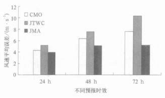
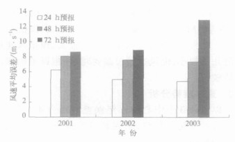
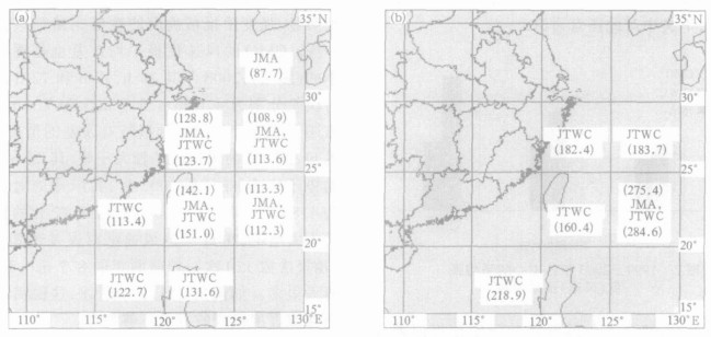
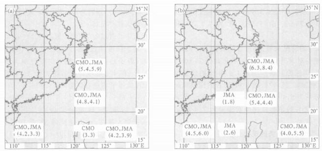
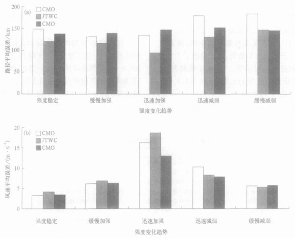
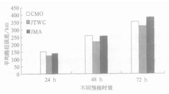
摘要: 应用1999—2003年中国中央气象台 (CMO)、日本气象厅 (JMA) 以及美国联合台风警报中心 (JTWC) 发布的西北太平洋热带气旋综合预报资料, 从总误差、逐年误差趋势、不同海区误差、不同路径趋势误差、不同强度趋势误差等5个方面对各预报中心的路径及强度预报结果进行分析, 结果表明:5年总的平均误差以JTWC的路径预报误差最小, 而JMA的强度预报较准确; 在不同海域, 各预报中心的路径预报能力各有优势, 但在热带气旋的强度预报方面, JMA的方法在各海区都较稳定; 对不同路径趋势热带气旋的预报方面, 除了南海转向热带气旋的路径预报比JMA和CMO稍差一些之外, JTWC的路径预报在大多数情况下都是好于或相当于JMA和CMO; 在不同强度变化趋势热带气旋的预报方面, JTWC在大多数情况下都优于其他中心。上述结果帮助业务和科技人员全面了解各预报中心的预报能力优劣, 也为今后改进我国的热带气旋预报提供有益的参考。Abstract: Based on the official forecasts of tropical cyclone (referred as TC hereinafter) in the Northwest Pacific from 1999 to 2003, real time error analysis is carried out for China Central Meteorological Observatory (CMO), Japan Meteorological Agency (JMA) and Joint Typhoon Warning Center (JTWC). Five aspects such as total error, annual error, different sea-areas, different tracks and different intensity trends are considered to compare the error characteristics of each forecast center in detail. Evidence suggests that JTWC's path error is the least and JMA has the best behavior in intensity forecast from a view of 5-year average. In great probability, all centers may overestimate TC's intensity, but when underestimating occurs, the bias always turn out to be a bigger one. After the year of 2000, all centers' performances improve greatly. As for CMO, Its track errors are less than 150 km (24 h) and 250 km (48 h) respectively. Over different see-areas, there is always a better path forecast among the three centers:JTWC behaves better at West-Luzon area. JMA has a overwhelming superiority on others at Che ju area. Its 24 h error is just 88 km, while the others produce an average of about 130 km. At South-Ryukyu area, JMA and JTWC perform obviously better than CMO whose track bias averages out to 155 km in 24 h and 340 km in 48 h forecast, while others just make out a value of 110 km and 280 km respectively. In most cases, JMA's intensity forecast is the best, but there isn't a obvious gap between CMO and JMA. JTWC's result is the poorest. As to different TC tracks, except for those veering at South China Sea, JTWC's path forecast is often the best. For intensity forecast, all centers make poor behaviors in turnabout track, while JMA and CMO perform better in Veering-after-landing and Northeastward tracks. For tropical cyclones with different intensity trends, JTWC mostly gives out a better path, especially for rapid intensification cases. Generally, all members make poorer path forecast for weakening cases. Intensity error of steady TC is the smallest, while that of rapid intensification is particularly bigger than others. That means more attention should be paid on researching and forecasting of rapid change TC, including rapid intensifying and rapid weakening.These results help to understand entirely forecast qualities of the three main forecast centers and give some guidance for forecasters when they make references on these centers' forecast results, and above statistics and analysis can be either a base or a direction for concerning research.
-
Key words:
- the Northwest Pacific;
- tropical cyclone;
- track error;
- intensity error;
-
表 1 各预报中心对不同路径趋势TC的预报误差比较

-
[1] 杨金彪, 郑耀文.中央台和日本数值模式热带气旋预报误差的对比检验.山东气象, 1994, 14(4):20-22. http://www.cnki.com.cn/Article/CJFDTOTAL-SDQX404.005.htm [2] 费亮, 徐一鸣, 雷小途.我国热带气旋的业务工作及异常运动研究.大气科学研究与应用, 1999, (1):114-125. [3] 孙秀荣, 余晖, 雷小途, 等.2001年西北太平洋热带气旋综述.大气科学研究与应用, 2002, (1):107-117. [4] 陈佩燕, 于润玲, 余晖, 等.2002年西北太平洋热带气旋综述.大气科学研究与应用, 2003, (1):101-113. [5] 杨彩福, 谭杰, 徐海坡.南海热带气旋路径预报.海洋预报, 2001, 18(2):30-38. [6] 杨元琴.热带气旋路径预报的MCE客观综合决策方法研究.气象, 2003, 29(5):3-8. http://www.cnki.com.cn/Article/CJFDTOTAL-QXXX200305001.htm [7] 雷小途.西北太平洋热带气旋最佳定位的精度分析.热带气象学报, 2001, 17(1):65-70. http://www.cnki.com.cn/Article/CJFDTOTAL-RDQX200101006.htm [8] Holland G. Global Guide to Tropical Cyclone Forecasting.WMO/TD-No.560, Geneva:WMO, 1993. http://reliefweb.int/report/world/global-guide-tropical-cyclone-forecasting [9] 闫俊岳, 张秀芝, 陈乾金, 等.热带气旋迅速加强标准的研究.气象, 1995, 21(5):9-13. http://www.cnki.com.cn/Article/CJFDTOTAL-QXXX505.001.htm [10] 张光智, 徐祥德, 王继志, 等.采用外场观测试验资料对登陆台风"黄蜂"的风场及湍流特征的观测研究.应用气象学报, 2004, 15(增刊):110-115. http://www.cnki.com.cn/Article/CJFDTOTAL-YYQX2004S1015.htm [11] 王瑾, 江吉喜. AMSU资料揭示的不同强度热带气旋热力结构特征.应用气象学报, 2005, 16(2):159-166. http://qikan.camscma.cn/jams/ch/reader/view_abstract.aspx?file_no=20050234&flag=1 [12] 麻素红, 瞿安祥, 张眙.台风路径数值预报模式的并行化及路径预报误差分析.应用气象学报, 2004, 15(3):322-328. http://qikan.camscma.cn/jams/ch/reader/view_abstract.aspx?file_no=20040341&flag=1 -


 设为首页
设为首页 加入收藏
加入收藏


 下载:
下载:
