一次孟加拉湾风暴和冷空气影响下滇西大暴雨中尺度分析
Mesoscale Analysis on a Heavy Rain Associated with a Bengal Bay Storm and Cold Air in West Yunnan
-
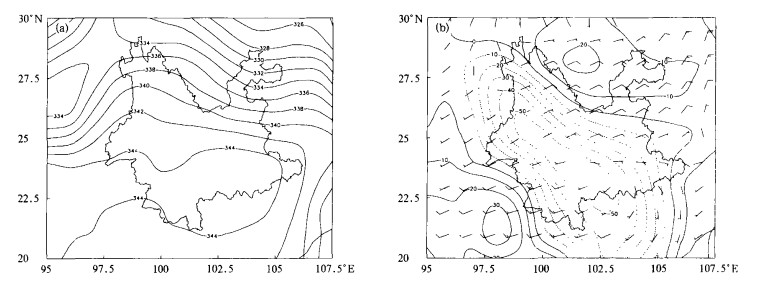
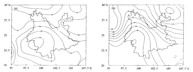
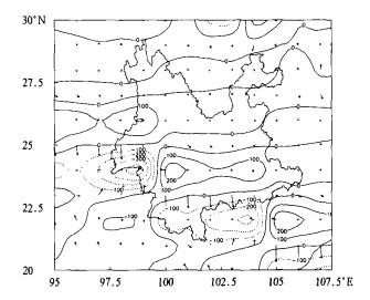
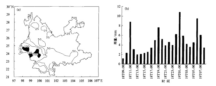
摘要: 应用MICAPS资料, 通过天气诊断分析, 结合FY-2卫星云图及德宏CINRAD-CC雷达体扫资料, 分析了发生在2004年5月18日滇西地区的大暴雨过程。发现本次大暴雨过程天气尺度影响系统为初夏孟加拉湾风暴及南下冷锋切变; 大暴雨发生在高能高湿的水汽辐合中心、700 hPa螺旋度正值区及湿 Q 矢量散度大值辐合区内; 卫星云图上, 多个β-中尺度对流系统在大暴雨区发展; 多普勒雷达回波为絮状混合型降水回波, 强度在30~44 dBz之间, 频繁出现的逆风区、低空急流、中尺度辐合线等中小尺度系统是造成本次大暴雨的直接影响系统。Abstract: A severe tropical storm develops over the Bengal Bay at the mid May, 2004. Jointly affected by the Bangal Bay storm and cold air and wind shear, a heavy rainstorm which lasts 3 days hits Yunan Province with the rainband stretching mainly from the west to the south. From 08:00 (BT) May 18 to 08:00 (BT) May 19, a severe rainfall occurs in west Yunnan with the centers in Baoshan, Dehong and Lincang. 24-hour rainfall is over 100 mm in 6 county stations, the rainfall center is at Longling of Baoshan with the 24-hour rainfall reaching 124.3 mm. It is the first time that such a concentrated heavy rain occurrs in a circular area of 180 km radius in Yunan.The tropical storm is one of the important weather systems which cause severe rainstorm in China. There are a lot of scientific investigations on the occurrence and evolution of the tropical storm (typhoon) over the west Pacific Ocean. Thus the forecasting ability on the tropical storm (typhoon) over the west Pacific Ocean has been improved. However, researches on the tropical storms originated in the Bengal Bay are still few. In fact, the storm of the Bengal Bay has significant impacts on the rainstorm in the southwest China. To explore the physical mechanism of the heavy rain in west Yunnan occurring on May 18, 2004, the MICAPS products, FY-2 satellite images and Dehong CINRAD-CC Doppler radar volume scan data are taken into account for the investigations. Moisture flux divergence, K index, Si index and Q vector divergence show that the synoptic scale affecting systems are the storm over the Bengal Bay and the southward cold front shear. The heavy rain occurs in the favorable environment field where the centers of water vapor convergence with high instability energy and high wet, positive helicity region at 700 hPa level and convergence area of wet-Q vector are located. Also, the satellite images present that the evolutions of some meso-β scale convective systems are the key of the heavy storm. And Doppler tracking observations give the facts that the echoes are mixed wadding rain echo with intensity between 30~44 dBz, the direct factors of the process are the meso-and small-scale systems such as frequent inverse wind, low level jet and meso-scale convergence line.
-
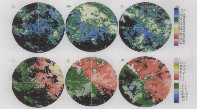
图 8 2004年5月18日德宏雷达回波图(色标同图 7, 距离毎圈30 km)
(a) 12:56径向速度图, 3.4°仰角, (b) 12:56反射率因子图, 3.4°仰角, (c) 12:00 RHI剖面图,方位角为245°
-
[1] 黄文根, 邓北胜, 熊廷南.一次台风暴雨的初步分析.应用气象学报, 1997, 8 (2): 247-251. http://qikan.camscma.cn/jams/ch/reader/view_abstract.aspx?file_no=19970234&flag=1 [2] 陈淑琴, 黄辉, 邵春海.南海登陆热带气旋对长江三角洲地区降水的影响.应用气象学报, 2004, 15 (6): 688-695. http://qikan.camscma.cn/jams/ch/reader/view_abstract.aspx?file_no=20040685&flag=1 [3] 麻素红, 瞿安祥, 张眙.台风路径数值预报模式的并行化及路径预报误差分析.应用气象学报, 2004, 15 (3): 322-328. http://qikan.camscma.cn/jams/ch/reader/view_abstract.aspx?file_no=20040341&flag=1 [4] 魏锦成, 吴陈锋, 杨奇志.热带气旋北冕暴雨多普勒雷达分析.气象, 2004, 30 (11): 32-34. http://www.cnki.com.cn/Article/CJFDTOTAL-QXXX200411007.htm [5] 段旭, 李英, 许美玲, 等.低纬高原地区中尺度天气分析与预报.北京:气象出版社, 2004: 105-108. [6] 张兴旺.湿矢量表达式及其应用.气象, 1998, 24 (8): 3-7. [7] 张培昌, 杜秉玉, 戴铁丕.雷达气象学.北京:气象出版社, 2001: 280-493. -


 设为首页
设为首页 加入收藏
加入收藏


 下载:
下载:
