西南季风潮与2004年5月我国南方暴雨
The Relationship Between the South-west Monsoon Tide and the Rain Storms over South China in May 2004
-
摘要: 以2004年5月初及5月中旬我国华南等地两次较大暴雨过程为例, 分析了西南季风潮与我国前汛期降水的关系。初步结论指出:西南季风潮的爆发与我国华南降水, 特别是大暴雨的形成关系极为密切, 而这次西南季风潮的爆发又与来自南半球的越赤道气流直接有关。同时指出, 这次西南季风潮的爆发主要与来自85°~95°E孟加拉湾地区所在经度的越赤道气流有关, 它们是印度洋“半球间宏观系统”的一个部分。而南海季风潮仅仅是西南季风潮的一种特例, 在这两次重大降水过程中没有南海季风潮的爆发和影响。Abstract: The relationship between the south-west monsoon tide (SWMT) and the precipitation from April to June in China is analyzed in terms of the examples of two rain storms in South China on 8 and 11—21 May 2004. The preliminary result shows that the outbreak of the SWMT is connected with the cross-equator flow (CEF) coming from the south hemisphere immediately. By means of the weather map, grid wind data, satellite cloud images as well as the Quikscat wind fields at 10 m level over sea surface, evidence shows that the main northern precipitation influencing systems including cold front, occluded front, ground small high pressure, upper troposphere cold vortex, inclined trough, shear line and so on. The cold air guided by these systems moves southward and plays an important role in the formation of the heavy rainfall. The southern precipitation systems are the water vapor and the cloud band caused by the outbreak of the SWMT leaded by the CEF at 85°~95°E (the longitude degree of the bay of Bengal) and 105°E, and the tropical cloud cluster is formed by the interaction between the SWMT and Himalaya Mountains. These cloud clusters with high temperatures, high humidities and high instabilities are transferred to the south and southwest of China and interact with the cold air, cause the rain storms and persistent precipitations. The analysis shows that the precipitation systems are closely connected with the "large-scale system between the two hemispheres". They are the primary cause of strong convective weather, rain storms and tornados generated over southern China.The precipitation progresses is mainly connected with SWMT over the bay of Bengal region. But the South China Sea monsoon tide hasn't occurred at that time. So the South China Sea monsoon tide can be regarded as one part of the Asia south-west monsoon tide. In order to get the final conclusion, more studies on this question should be done in the future.
-
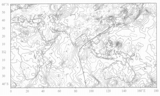
图 4 2004年5月14日东半球850 hPa风场图
(粗实线为最大南风轴线图, 说明同图 3)
-
[1] 竺可桢.东南季风与中国之雨量∥竺可桢文集.北京:科学出版社, 1979:283-297. [2] 陶诗言.中国之暴雨.北京:科学出版社, 1980. [3] Ding Yihui.Monsoons over China. London:Kluwer Academic Publisher.1994:1-90. [4] 田生春, 李麦村, 杜杰, 等.广东省前汛期一场持续性暴雨的分析.中国科学院大气物理研究所集刊第9号:暴雨及强对流天气的研究.北京:科学出版社:70-77. [5] 谢巨伦.南海首次西南季风潮爆发迟早的分析及预报.海洋通报, 2000, 19(1):70-77. http://www.cnki.com.cn/Article/CJFDTOTAL-HUTB200001003.htm [6] 闫俊岳, 唐志毅, 姚华栋, 等.2002年南海季风建立及其雨带变化.气象学报, 2003, 61(5):569-579. http://www.cnki.com.cn/Article/CJFDTOTAL-QXXB200305006.htm [7] 李曾中.越赤道气流与中国天气关系的初步统计分析.气象, 1986, 12(4):11-14. http://www.cnki.com.cn/Article/CJFDTOTAL-QXXX198604002.htm [8] 王兴东, 陶诗言.西太平洋越赤道气流的初步研究.海洋学报, 1984, 6(2):160-173. http://www.cnki.com.cn/Article/CJFDTOTAL-SEAC198402002.htm [9] 汤明敏, 黄仕松, 周德佩.全球越赤道气流的时空变化.热带气象, 1985, 1(4):287-295. http://www.cnki.com.cn/Article/CJFDTOTAL-RDQX198504000.htm [10] 孙淑清.东亚大尺度低空急流的背景场与东半球的越赤道气流.气象学报, 1986, 44(1):55-62. http://www.cnki.com.cn/Article/CJFDTOTAL-QXXB198601006.htm [11] 李宪之.降水问题.北京:海洋出版社, 1987:234-236. [12] 李宪之.减轻几种主要自然灾害的途径∥仇永炎. "寒潮台风灾害"———庆贺李宪之教授九十五华诞文集.北京:气象出版社, 2001:369-374. -


 设为首页
设为首页 加入收藏
加入收藏


 下载:
下载:


