
 设为首页
设为首页 加入收藏
加入收藏

西藏藏北高原典型植被生长对气候要素变化的响应
The Response of Typical Vegetation Growth to Climate Conditions in North Tibetan Plateau
-
摘要: 选取西藏藏北高原西部高寒草原植被、中部高寒草甸植被及东南部高寒灌丛草甸植被 3 种藏北地区最典型的植被类型, 结合临近 3 个气象观测站的资料, 分析这 3 种典型植被类型地区 1999—2001 年旬平均气温、旬总降水量和 SPOT VEGETATION 卫星 10 d 最大值合成归一化植被指数 (NDVI) 变化特征以及 3 种典型植被基于 SPOT VEGETATION NDVI 的生长变化对旬平均气温和旬总降水量两个主要气候要素变化的响应关系。 结果表明: 藏北地区降水资源的空间分布特点是东南部向西北部逐渐减少, 气温则由南向北逐渐递减, 与降水资源分布相反, 蒸发量西部高, 东部低; SPOT VEGETATION NDVI 能够较为准确地反映 3 种典型植被生长变化特征, 所反映的植被返青期和枯黄期等重要植被生长阶段与由积温计算的植被生长特征基本一致; 藏北地区基于 SPOT VEGETATION NDVI 的植被生长变化与气温的相关系数明显高于与降水的相关系数 , 其中以那曲为代表的高寒草甸植被的 NDVI 与旬气温和旬降水总量的相关系数最大, 分别为 0.81 和 0.68 , 表明藏北地区由于海拔高, 气候寒冷, 气温对该地区植被生长的影响明显高于降水的影响, 即该地区植被生长变化对气温的响应程度明显高于对降水的响应程度 , 是植被生长的限制性因素; 不同植被类型对气温和降水两个要素的响应程度大小依次是高寒草甸、高寒灌丛草甸和高寒草原。
-
关键词:
- 植被生长;
- 气候要素;
- SPOT VEGETATION;
- 藏北高原
Abstract: Based on the scanned and georeferenced vegetation map of North Tibetan Plateau from 1:1000000 China Vegetation Atlas and grassland resource map of the North Tibetan Plateau, alpine steppe in the western North Tibetan Plateau, alpine meadow in the central North Tibetan Plateau and alpine shrub meadow in the eastern North Tibetan Plateau are selected as three most typical vegetation types in the North Tibetan Plateau. First, the climate conditions in North Tibetan Plateau are analyzed. Secondly, the ten-day mean temperature and precipitation and SPOT VEGETATION ten-day maximum composite NDVI (normalized difference vegetation index) of three typical vegetation regions from 1999 to 2001 are studied. Finally, the relationships between vegetation growth based on the SPOT VEGETATION ten-day maximum composite NDVI and the ten-day mean temperature and ten-day precipitation as two key climate variables that affect vegetation growth in these regions are analyzed. The spatial distribution of the precipitation decreases from southeast to northwest and that of the temperature decreases from south to north in the North Tibetan Plateau. Contrary to the precipitation, evaporation is higher in west than that in east in the North Tibetan Plateau. SPOTV EGETATION NDVI variations can represent the three typical vegetation growth patterns. In two important vegetation growth periods, the date of the green-up initiation and withering of vegetation represented by NDVI is consistent with the vegetation growth phases by calculating from accumulated temperature. The coefficients between NDVI and corresponding temperature from 1999 to 2001 in the alpine steppe is 0.66, in alpine meadow 0.81, and in alpine shrub meadow 0.79, while the coefficients between NDVI and precipitation in three different vegetation types are 0.53, 0.68 and 0.54, respectively. It means that NDVI variations in the North Tibetan Plateau are more sensitive tothe temperature than to precipitation. Because of the high altitude and frigid climate in the North Tibetan Plateau, the impact of the temperature on the vegetation growth markedly is higher than that of the precipitation. The temperature is the main confining factor for vegetation growth in the North Tibetan Plateau. Response degree of three typical vegetations to climate variations in the North Tibetan Plateau from high to low arealpine meadow, alpine shrub meadow and alpine steppe, respectively . -

图 1 1999—2001年藏北3种植被类型地区旬平均气温变化趋势
Fig. 1 The ten-day mean temperature variations of the three typical vegetation types in North Tibetan Plateau from 1999 to 2001
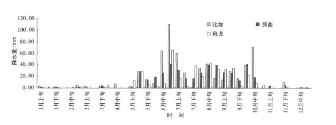
图 2 1999年藏北3种植被类型地区旬降水总量变化趋势
Fig. 2 The ten-day total precipitation variations of the three typical vegetation types in North Tibetan Plateau for 1999

图 3 1999—2001年藏北3种植被类型地区 SPOT VEGETATION 变化趋势
Fig. 3 SPOT VEGETATION NDVI changes of the three typical vegetation types in North Tibetan Plateau from 1999 to 2001
表 1 藏北地区主要气候要素特征
Table 1 Climate conditions in North Tibetan Plateau

表 2 藏北地区主要植被类型返青期与日平均气温稳定通过0℃, 5℃初日的关系[21]
Table 2 The relationships between green-up initiation of the three typical vegetation types and beginning data of daily mean temperature passing 0℃ and 5℃[21]

表 3 藏北地区3种典型植被枯黄期与日平均气温≥5℃终日的关系[21]
Table 3 The relationships between the senescence of the three typical vegetation types and ending data of daily mean temperature passing 5℃

表 4 1999—2001年 SPOT VEGETATION NDVI 与旬气候要素的相关关系
Table 4 The relationships between SPOT VEGETATION NDVI and ten-day temperature and precipitation in North Tibetan Plateau from 1999 to 2001

-
[1] Neilson R P. High-resolution climatic analysis and southwest biogeography. Science, 1986, 232: 27-34. doi: 10.1126/science.232.4746.27 [2] Lu L, Pielke R A, Liston G E, et al. Implementation of a twoway interactive atmospheric and ecological model and its application to the central United States. J Climate, 2001, 14: 900-919. doi: 10.1175/1520-0442(2001)014<0900:IOATWI>2.0.CO;2 [3] Betts R A, Cox P M, Lee S E, et al. Contrasting physiological and structural vegetation feedbacks in climate change simulations. Nature, 1997, 387: 796-800. doi: 10.1038/42924 [4] Bounoua L, Collatz G J, Los S O, et al. Sensitivity of climate to changes in NDVI. J Climate, 2000, 13: 2277-2292. doi: 10.1175/1520-0442(2000)013<2277:SOCTCI>2.0.CO;2 [5] 杨星卫,周红妹,李军, 等. 全球稻谷主产国遥感估产可行性研究. 应用气象学报, 1998, 9(2): 251-256. http://qikan.camscma.cn/jams/ch/reader/view_abstract.aspx?file_no=19980235&flag=1 [6] 郑照军,刘玉洁,张炳川.中国地区冬季积雪遥感监测方法改进. 应用气象学报, 2004, 15(增刊): 75-84. http://kns.cnki.net/KCMS/detail/detail.aspx?dbcode=CJFQ&dbname=CJFD2004&filename=YYQX2004S1011&v=MTM5NjRSTDJmWk9Sc0Z5em5Wci9QUERUYWRyRzRIdFd2cm85RVpZUjhlWDFMdXhZUzdEaDFUM3FUcldNMUZyQ1U= [7] Tucker C J, Townshend R G, Goff T E. African land-cover classification using satellite data. Science, 1985, 227: 369-375. doi: 10.1126/science.227.4685.369 [8] Justice C O, Hiernaux P H Y. Monitoring the grasslands of the Sahel using NOAA AVHRR data: Niger 1983. Int J Remote Sensing, 1986, 7: 1475-1497. doi: 10.1080/01431168608948949 [9] Richard Y, Poccard I A. Statistical study of NDVI sensitivity to seasonal and in terannual ranfial variations in Southern Africa. Int J Remote Sensing, 1998, 19: 2907-2920. doi: 10.1080/014311698214343 [10] M ilich L, Weiss E. GAC NDVI images: Relationship to rainfall and potential evaporation in the grazing lands of the Gourma (Northern Sahel)and in the croplands of the Niger-Nigeria border (Southern Sahel). Int J Remote Sensing, 2000, 21(2): 261-280. doi: 10.1080/014311600210821 [11] Weissa J L, Gutz lera D S, Allred Coonrod J E, et al. Seasonal and inter-annual relationships between vegetation and climate New Mexico, USA. Journal of Arid Environments, 2004, 57: 507-534. doi: 10.1016/S0140-1963(03)00113-7 [12] 陈云浩,李晓兵,史培军. 1983—1992年中国陆地NDVI变化的气候因子驱动分析.植物生态学报, 2001, 25(6):716-720. http://www.cnki.com.cn/Article/CJFDTOTAL-ZWSB200106011.htm [13] 李本纲,陶澍. AVHRR NDVI与气候因子的相关分析.生态学报, 2000, 20(5): 898-902. http://www.cnki.com.cn/Article/CJFDTOTAL-STXB200005028.htm [14] 李晓兵,王瑛,李克让.NDVI对降水季节性和年际变化的敏感性. 地理学报, 2000, 55(增刊):82-89. http://www.cnki.com.cn/Article/CJFDTOTAL-DLXB2000S1013.htm [15] 除多. 基于NOAA AVHRR NDVI的西藏拉萨地区植被季节变化. 高原气象, 2003, 22(增刊):145-151. http://www.cnki.com.cn/Article/CJFDTOTAL-GYQX2003S1019.htm [16] 西藏自治区阿里地区农牧局. 西藏阿里地区土地资源. 北京: 中国农业科技出版社, 1991. [17] 西藏自治区那曲地区畜牧局. 西藏那曲地区土地资源. 北京: 中国农业科技出版社, 1992. [18] 中国科学院青藏高原综合科学考察队. 西藏气候.北京:科学出版社, 1994. [19] Bella C D, Faiver R, Ruget F, et al. Use of Spot4 Vegetation satellite data to improve pasture production simulated by STICS included in the ISOP French system. Agronomie, 2004, 24: 437-444. doi: 10.1051/agro:2004034 [20] 中国科学院中国植被图编辑委员会.1:1000000 中国植被图集.北京:科学出版社, 2001. [21] 刘雪松,马玉才,拉巴.那曲地区牧业气候区划. 北京:气象出版社, 2003. -

 下载:
下载:
计量
- 摘要浏览量: 3166
- HTML全文浏览量: 596
- PDF下载量: 2310
- 被引次数: 0
