
 设为首页
设为首页 加入收藏
加入收藏

雷达资料在孤立单体雷电预警中的初步应用
The Prelimiary Application of Radar Data to the Lightning Warning of Isolated Storm Cells
-
摘要: 利用多普勒雷达资料, 结合探空、闪电资料对2005年夏季北京地区的20个单体过程进行综合分析, 结果表明:40 dBz是比较适合该地区雷电预警的一个雷达回波特征参量; 在此基础之上, 将0 ℃层结高度作为基础特征高度, 并结合-10 ℃层结高度和强回波所占比例对孤立单体的雷电发生进行综合预警是一种较为接近实际应用的方法。根据以上分析, 该文针对孤立单体能否发生闪电、以及闪电发生的起始时间给出了一个初步的预报方法, 并利用22个孤立单体进行了检验。检验结果证明:该方法在对单体是否会发展为雷暴单体, 以及雷暴单体中初次闪电发生时段的预报方面效果较好。同时还发现, 雷暴单体中从25 dBz回波出现到单体的35 dBz回波厚度变化率达到极值的时间差, 与雷暴中最早的云闪与最早的地闪之间的时间差, 两者存在一定的线性关系。这为进一步预测地闪的发生提供了一个参考依据。Abstract: The radar data, the sounding data and the lightning location data of 20 isolated cells in Beijing from July to August in 2005 are analyzed. Considering the analysis and the overseas studies, it is concluded that 40 dBz is an appropriate predictor for the regional lightning warning, because the difference of 40 dBz echo top between thunderstorms and non-thunderstorms is maximal among various echoes. The application of this predictor is not as simple as other research results. According to the analysis on the evolution of various echoes, it is considered that the threshold of 40 dBz echo top height should be located at the 0 ℃ stratification level. In the meantime, whether 40 dBz echo top height reaches the -10 ℃ stratification level, the proportion of some kinds of echo should be taken into account. The forecast accuracy will be improved markedly when the factors mentioned before are taken into consideration. Based on the above studies, a forecast process of lightning is given. First, it is checked that whether the 0 ℃ stratification level is reached by the 40 dBz echo top height or not. If it is affirmative, the cell will have the great potential of becoming a thunderstorm. If not, the cell will be concluded to be a non-thunderstorm. Then, checking whether the -10 ℃ stratification level is reached by the 40 dBz echo top height will be necessary to judge the thunderstorm further. If that height is reached, the first lighting in the cell will occur in 15 minutes. If not, the P value should be used for subsidiary discrimination. If the P value exceeds 5% and keeps above this level for a period of time, the first lightning will also occur in 15 minutes. A prediction test for this method is carried out using the data of the other 22 isolated cells in Beijing in the same period. The test result shows that the method is effective in judging whether a normal cell will become a non-thunderstorm cell or not and predicting the time of the first lightning in a thunderstorm. In addition, a linear relationship is found between two time intervals. One interval is between the occurring time of the first intercloud flash (IC) and the first cloud-to-ground (CG) in a cell. Another is between the appearing of the first 25 dBz in the cell and the V value (change rate of 35 dBz echo thickness in the cell) reaching its maximum. A reference is given for the CG prediction.
-
Key words:
- radar echo;
- echo top height;
- thickness change rate;
- lighting warning
-

图 1 各单体30, 35, 40 dBz回波顶高突破0 ℃层结高度百分比对照图
Fig. 1 The percentage contrast of cells classified by various echo top (30 dBz, 35 dBz, 40 dBz) reached the 0 ℃ stratification level
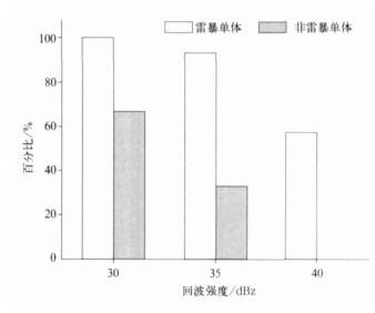
图 2 各单体30, 35, 40 dBz回波顶高突破-10 ℃层结高度百分比对照图
Fig. 2 The percentage of cells classified by various echo top (30 dBz, 35 dBz, 40 dBz) reached the -10 ℃ stratification level

图 3 一次孤立雷暴单体40 dBz回波顶高演变
Fig. 3 The variability of 40 dBz echo top of an isolated thunderstorm
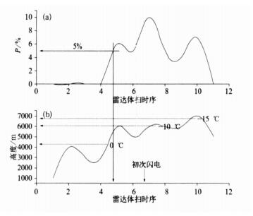
图 4 一次孤立雷暴单体P值 (a) 及其40 dBz回波顶高 (b) 的演变
Fig. 4 The variation of P value (a) and 40 dBz echo top (b) of an isolated thunderstorm
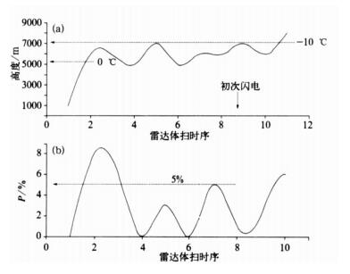
图 5 一次孤立雷暴单体40 dBz回波顶高 (a) 及其P值 (b) 演变
Fig. 5 The variability of 40 dBz echo top (a) and the P value (b) of an isolated thunderstorm

图 6 T与T′的线性关系
(T:单体中从出现25 dBz回波到35 dBz回波最大厚度变化率达到极大值的时间差; T′:单体中初次云闪与初次地闪之间的时间差)
Fig. 6 The linear relationship between T and T′
(T:the time difference from 25 dBz firstly appeared to the maximun V; T′:the time difference from the first cloud flash occurred to the first CG)
表 1 20个单体在雷达及闪电发生方面的情况汇总
Table 1 The lightning information of 20 cells

-
[1] Serge Soula, Serge Chauzy. Some aspects of the correlation between lightning and rain activities in thunderstorms. Atmospheric Research, 2001, 56:355-373. doi: 10.1016/S0169-8095(00)00086-7 [2] Battan L J. Some factors governing precipitation and lightning from convective clouds. J Atmos Sci, 1965, 22:79-84. doi: 10.1175/1520-0469(1965)022<0079:SFGPAL>2.0.CO;2 [3] Sheridan S C, Griffiths J H, Orville R E. Warm season cloudto-ground lightning precipitation relationships in the South-Central United States. Wea Forecasting, 1997, 12:449-458. doi: 10.1175/1520-0434(1997)012<0449:WSCTGL>2.0.CO;2 [4] Piepgrass M V, Krider E P, Moore C B. Lightning and surface rainfall during Florida thunderstorms. J Geophys Res, 1982, 87 (13):11193-11201. [5] 陈哲漳.冰雹与雷暴大风的云对地闪电特征.气象学报, 1995, 53(3):367-374. http://www.cnki.com.cn/Article/CJFDTOTAL-QXXB503.012.htm [6] 张义军, 孟青, 马明, 等.闪电探测技术发展和资料应用.应用气象学报, 2006, 17(5):611-620. http://qikan.camscma.cn/jams/ch/reader/view_abstract.aspx?file_no=200605104&flag=1 [7] Blyth A M, Christian H J, Driscoll K, et al. Determination of ice precipitation rates and thunderstorm anvil ice contents from satellite observations of lightning. Atmos Res, 2001, 59-60: 217-229. doi: 10.1016/S0169-8095(01)00117-X [8] Baker M B, Christian H J, Latham J. A computational study of the relationships linking lightning frequency and other thundercloud parameters. Q J R Meteorol Soc, 1995, 121:1525-1548. doi: 10.1002/(ISSN)1477-870X [9] Baker M B, Blyth A M, Chiristian H J, et al. Relationships between lightning activity and various thundercloud parameters: Satellite studies. Atmos Res, 1999, 51:221-236. doi: 10.1016/S0169-8095(99)00009-5 [10] Petersen W A, Rutledge S A. Regional variability in tropical convection:Observations from TRMM. J Climate, 2001, 14: 3566-3586. doi: 10.1175/1520-0442(2001)014<3566:RVITCO>2.0.CO;2 [11] Buechler D E, Wright P D, Goodman S J. Lightning-rainfall Relationships during COHMEX. Proc Conf on Atmospheric Electricity, Alta, Canada, AMS, 1990. [12] Wiebke Deierling, John Latham, Walter A Petersen, et al. On the relationship of the thunderstorm ice hydrometeor characteristics and total lightning measurements. Atmos Res, 2005, 76: 114-126. doi: 10.1016/j.atmosres.2004.11.023 [13] Maribel Martinez. The Relationship Between Radar Reflectivity and Lightning Activity at Initial Stages of Convective Storms. American Meteorological Society, 82nd Annual Meeting, First Annual Student Conference, Orlando, Florida, 2002. [14] Brandon R Vincent, Lawrence D Carey, Douglas Schneider, et al. Using WSR-88D reflectivity for the prediction of cloud-toground lightning:A central north carolina study. National Weather Digest, 2003, 27:35-44. https://www.researchgate.net/publication/268295227_Using_WSR-88D_reflectivity_data_for_the_prediction_of_cloud-to-ground_lightning_a_North_Carolina_study [15] 孟青, 葛润生, 朱小燕.SAFIR闪电检测和预警系统.气象科技, 2002, 30(3):135-138. http://www.cnki.com.cn/Article/CJFDTOTAL-QXKJ200203001.htm [16] Takahashi T. Riming electrification as a charge generation mechanism in thunderstorms. J Atmos Sci, 1978, 35:1536-1548. https://www.researchgate.net/publication/234294413_Riming_Electrification_as_a_Charge_Generation_Mechanism_in_Thunderstorms [17] 谢屹然, 郄秀书, 郭凤霞, 等.液态水含量和冰晶浓度对闪电频数影响的数值研究.高原气象, 2005, 24(4):598-603. http://www.cnki.com.cn/Article/CJFDTOTAL-GYQX200504019.htm [18] 言穆弘, 刘欣生, 安学敏, 等.雷暴非感应起电机制的模拟研究:Ⅰ.云内因子影响.高原气象, 1996, 15(4):425-437. http://www.cnki.com.cn/Article/CJFDTOTAL-GYQX604.004.htm -

 下载:
下载:
计量
- 摘要浏览量: 4455
- HTML全文浏览量: 715
- PDF下载量: 1855
- 被引次数: 0
