贵州高原起伏地形下日照时间的时空分布
The Spatial and Temporal Distribution of Insolation Duration over Rugged Terrains in the Guizhou Plateau
-
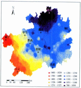
摘要: 由于坡度、坡向和地形之间相互遮蔽等局地地形因子的影响, 实际起伏地形下的日照时间与水平面上的日照时间有一定差异。该文建立了一种基于数字高程模型 (DEM) 的起伏地形下日照时间的模拟方法, 计算了起伏地形下贵州高原100 m×100 m分辨率日照时间的时空分布。结果表明:坡度、坡向、地形遮蔽对日照时间的影响较大, 实际起伏地形下日照时间的空间分布具有明显地域特征。1月太阳高度角较低, 坡度、坡向的作用非常明显, 地形遮蔽面积较大, 日照时间的空间差异较多, 日照时间为16~142 h, 最大值约为最小值9倍; 7月太阳高度角较高, 地形遮蔽面积相对较小, 日照时间的空间差异相对较少, 日照时间为133~210 h, 最大值为最小值1.6倍, 但由于7月日照时间相对较多, 局地地形对日照时间影响仍明显。4月、10月日照时间及其变化幅度介于1月和7月之间。Abstract: Due to local terrain factors such as slope, aspect and terrain inter-shielding, the insolation duration over rugged terrain is different from over horizontal surface. Calculating the insolation duration over rugged terrain is very difficult. In the mountainous regions of complicated landform and great height difference, the observation data of the existing weather stations are far from enough to reflect the spatial distribution of the complicated sunshine time.Guizhou Province, which is from 24°37′N to 29°13′N and from 103°36′E to 109°35′E, lies in the plateaus and mountains in the western China. The physiognomy of the whole Province falls roughly into the categories of plateaus, mountains, hilly land, and basins. 92.5% of the total land area is mountains and hilly land. Based on Digital Elevation Model (DEM) and Geographical Information System (GIS), the distributed models for calculating insolation duration over rugged terrain are developed. Applying the models to Guizhou Plateau with 100 m×100 m DEM data, the elaborated spatial distributions of insolation duration over rugged terrain are generated. The insolation duration over rugged terrain of considering slope, aspect and terrain inter-shielding is analyzed.The influences of slope, aspect and the terrain inter-shielding on sunshine duration are very big. The spatial distribution of sunshine duration has apparent terrain feature over rugged terrain. The solar altitude angle is quite low in January; the effect of slope, aspect is very apparent. The shadow areas of topography are relative large and the spatial difference of sunshine time is big. The insolation duration varies spatially from 16 to 142 hours, and the maximum is about 9 times as the minimum. The solar altitude angle is quite high in July; the shadow areas of topography are relative small. The insolation duration varies spatially from 133 to 210 hours, and the maximum is about 1.6 times as the minimum. But the sunshine time over horizontal surface is much in July, and the influence of local terrain on the insolation duration is still obvious. The insolation duration and its amplitude of variation vary between in January, July and in April, October. The annual average insolation duration varies spatially from 768 to 1824 hours, and the maximum one is about 2.4 times as the minimum one. The effect of slope, aspect and the terrain inter-shielding on annual sunshine duration is quite great. The spatial difference of it is very evident. Therefore, the effect of complex topography on insolation duration should be considered.
-
表 1 贵州高原起伏地形日照时间误差分析 (单位:%)
Table 1 The error analysis of insolation duration over rugged terrains in the Guizhou Plateau (unit:%)

-
[1] 朱延年, 朱琳, 郭兆夏, 等.基于GIS商洛山区日照时数模拟.陕西气象, 2004, (4):10-13. http://www.cnki.com.cn/Article/CJFDTOTAL-SXQI200404002.htm [2] 傅抱璞.坡地对日照和太阳辐射的影响.南京大学学报 (自然科学), 1958, (2):23-46. [3] 傅抱璞.山地可照时间的理论计算与变化特点∥么枕生.气候学研究———气候与中国气候问题.北京:气象出版社, 1993:20-25. [4] 翁笃鸣, 陈万隆, 沈觉成, 等.小气候和农田小气候.北京:农业出版社, 1981:115-116. [5] 翁笃鸣.农田可照条件的理论分析.气象科学, 1982, 2(1-2):73-88. http://www.cnki.com.cn/Article/CJFDTOTAL-QXKX1982Z1006.htm [6] 孙汉群, 傅抱璞, 于强.关于坡地上的日出日没时角问题.南京大学学报 (自然科学版), 1993, 29(地学专辑):154-158. [7] Klein S A.Calculation of monthly average insolation on tilted surfaces.Solar Energy, 1977, 19(4):325-329. doi: 10.1016/0038-092X(77)90001-9 [8] Iqbal M. An Introduction to Solar Radiation. Canada:Academic Press, 1983:23-28. [9] 朱志辉.非水平面天文辐射的全球分布.中国科学 (B辑), 1988, 18(10):1100-1110. http://www.cnki.com.cn/Article/CJFDTOTAL-JBXK198810011.htm [10] 魏丽, 殷剑敏, 黄淑娥, 等.贵溪市植被资源遥感调查和综合气候区划.应用气象学报, 2003, 14(6):715-721. http://qikan.camscma.cn/jams/ch/reader/view_abstract.aspx?file_no=20030690&flag=1 [11] 朱琳, 朱延年, 陈明彬, 等.基于GIS陕南商洛地区农业气候资源垂直分层.应用气象学报, 2007, 18(1):108-113. http://qikan.camscma.cn/jams/ch/reader/view_abstract.aspx?file_no=20070119&flag=1 [12] Granier B J, Atsuma Ohmura.A method of calculating the direct shortwave radiation income of slopes.J Appl Meteor, 1968, (7):796-808. doi: 10.1175/1520-0450%281968%29007<0796%3AAMOCTD>2.0.CO%3B2 [13] Williams L D, Barry R G, Andrews J T. Application of computed global radiation for areas of high relief.J Appl Meteor, 1972, 11:526. doi: 10.1175/1520-0450(1972)011<0526:AOCGRF>2.0.CO;2 [14] Dozier J, Outcalt S I. An approach to energy balance simulation over rugged terrain.Geographic Anal, 1979, 11:65-85. doi: 10.1111/j.1538-4632.1979.tb00673.x/abstract [15] Dozier J, Frew J. Rapid calculation of terrain parameters for radiation modeling from digital elevation data.IEEE Transaction on Geosciences and Remote Sensing, 1990, 28(5):963-969. doi: 10.1109/36.58986 [16] Bocquet G.Method of study and cartography of the potential sunny periods in mountainous areas.J Climatol, 1984, 1(4):587. doi: 10.1002/joc.3370040603/abstract?systemMessage=Wiley+Online+Library+will+be+unavailable+on+Saturday+25th+March+from+07%3A00+GMT+%2F+03%3A00+EDT+%2F+15%3A00+SGT+for+4+hours+for+essential+maintenance.++Apologies+for+the+inconvenience. [17] 李新, 程国栋, 陈贤章, 等.任意条件下太阳辐射模型的改进.科学通报, 1999, 44(9):993-998. http://www.cnki.com.cn/Article/CJFDTOTAL-KXTB199909023.htm [18] 曾燕, 邱新法, 缪启龙, 等.起伏地形下我国可照时间的空间分布.自然科学进展, 2003, 13(5):545-549. http://www.cnki.com.cn/Article/CJFDTOTAL-ZKJZ200305018.htm [19] 左大康.现代地理学辞典.北京:商务印书馆, 1990. -


 设为首页
设为首页 加入收藏
加入收藏


 下载:
下载:


