多普勒天气雷达资料同化对暴雨模拟的影响
Impacts of Chinese Doppler Radar on the Severe Heavy Rainfall Forecast During Meiyu Season
-
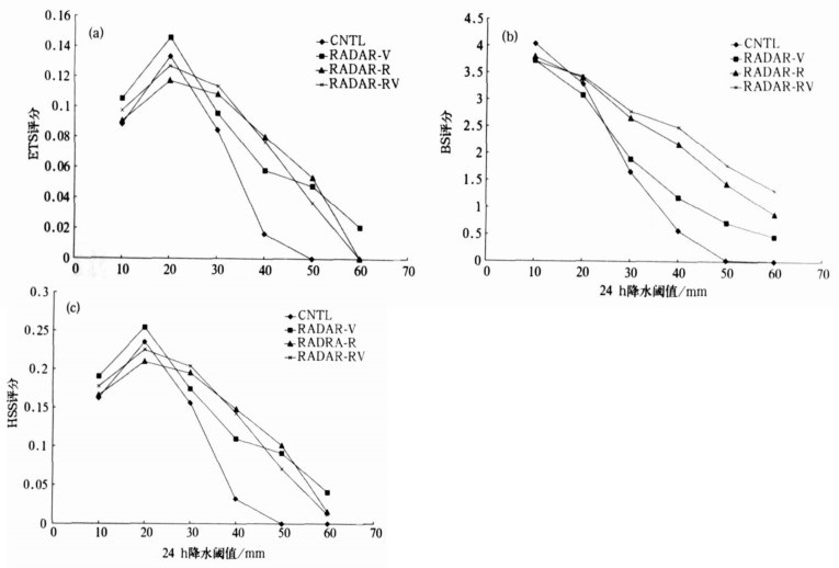
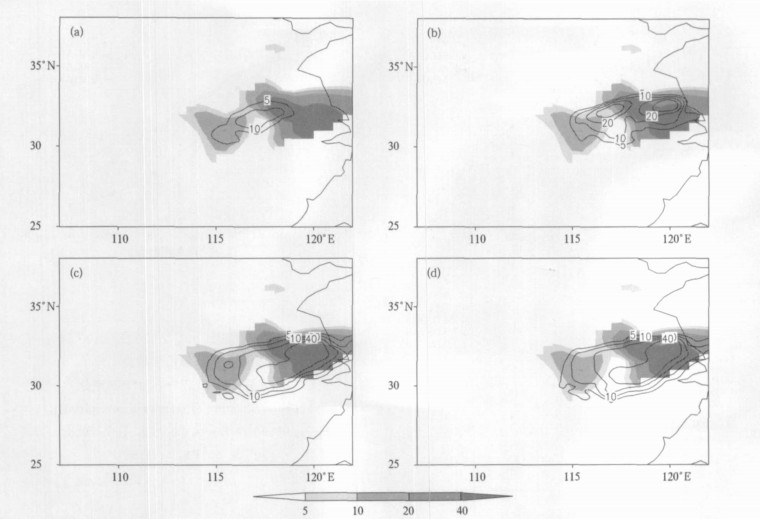
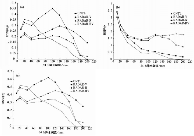
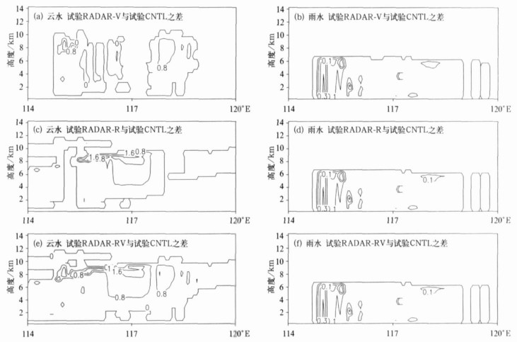
摘要: 利用我国CINRAD/SA多普勒天气雷达资料与ARPS模式 (Advanced Regional Prediction System) 的资料分析系统ADAS (ARPS Data Analysis System), 对初始场进行调整, 并应用于WRF (Weather Research and Forecasting Model) 模式, 对2003年梅雨期淮河流域两次典型致洪暴雨过程进行模拟试验。对模拟结果的对比分析和检验结果表明:引入雷达资料后, 在雷达观测区的整层风场和水汽场都随之调整, 雷达径向风和反射率因子资料对初始场调整有不同影响, 径向风资料侧重于对风场的调整, 而反射率因子资料侧重于对温、湿量场的调整, 使降雨落区和强度预报都有所提高; 在ADAS系统中, 雷达径向风和反射率因子资料对初始场调整有不同影响, 径向风资料侧重于对风场的调整, 而反射率因子资料侧重于对温、湿量场的调整, 两个个例的试验表明, 加入雷达径向风资料的模拟试验能够得到较好评分, 加入雷达反射率因子资料或同时加入这两种雷达资料也能够在一定程度上提高模拟的准确性。Abstract: CINRAD/SA Doppler radar data and ARPS data analysis system (ADAS) are used to adjust the initial field, then the adjusted initial field is inputted into the mesoscale model WRF (The Weather Research and Forecasting Model) to simulate two rainstorm processes. The two rainstorm processes produce a flash flooding over Huaihe River Basin during Meiyu of 2003. According to the difference of initial data to be used in the numerical simulation, four experiments are designed and conducted in the study. The initial field obtained without use of radar data in control run (Exp CNTL), with use of radial velocity in Exp RADAR-V, with use of radar reflectivity in Exp RADAR-V, with both radar reflectivity and radial velocity in Exp RADAR-RV. The simulated outputs of these four experiments are compared and verified. The results show that after the adjustment of initial field using radar data through the ARPS complex cloud analysis scheme, both wind field and moisture field are adjusted at the region of radar observation, and the initial fields carries more information about moisture, cloud, latent heat, meso-scale circulation, and so on. At the same time, the simulation results also show that the spin-up time of meso-scale model is shortened and accuracy of rainstorm simulation is improved. Through the quantitative verification of the simulation results, both the ETS and the HSS of experiments simulating the radar data in initial fields are proved higher than those of experiments not simulating the radar data in initial fields, and the BS verification score for the former experiments is more closer to 1.Based on the comparing of the results of these four experiments, it can concluded that the impacts of Doppler radar data assimilation on initial field are different between Exp RADAR-V and RADAR-R. In ADAS system, radar radial velocity observations are used to adjust the wind field, but radar reflectivity observations are used to adjust the thermal and moisture fields. The significant differences exist between simulation results of four experiments. On the basis of the quantitative verification, the Exp RADAR-V, which uses radar radial velocity, gets the highest score and is able to simulate meso-scale convective system and its rainfall more accurately. However, it is noticed that the other experiment, such as Exp RADAR-R and Exp RADAR-RV, also can improve the accuracy of rainfall simulation at a certain extent, though not as good as the results of Exp RADAR-V. In addition, the improvements of precipitation prediction are notable in the first six-hour simulation.
-
表 1 试验设计
Table 1 The configuration of experiments

-
[1] Kasahara A, Balgovind R C, Katz B.Use of satellite radiometric imagery data for improvement in the analysis of divergent wind in the tropics.Mon Wea Rev, 1988, 116:866-883. doi: 10.1175/1520-0493(1988)116<0866:UOSRID>2.0.CO;2 [2] Hu M, Xue M, Bratseth K. 3DVAR and cloud analysis with WSP-88D level-Ⅱ data for the prediction of the Fort Worth, Texas, tornadic thunderstorms. Part Ⅰ:Cloud analysis and its impact.Mon Wea Rev, 2006, 134:675-698. doi: 10.1175/MWR3092.1 [3] Hu M, Xue M, Gao J D. 3DVAR and cloud analysis with WSP-88D level-Ⅱ data for the prediction of the Fort Worth, Texas, tornadic thunderstorms. Part Ⅱ:Impact of radial velocity analysis via 3DVAR.Mon Wea Rev, 2006, 134:699-721. doi: 10.1175/MWR3093.1 [4] Xue M, Martin W J. A high-resolution modeling study of the 24 May 2002 dryline case during IHOP. Part Ⅰ:Numerical simulation and general evolution of the dryline and convection.Mon Wea Rev, 2006, 134:149-171. doi: 10.1175/MWR3071.1 [5] Xue M, Wang D H, Gao J D.The Advanced Regional Prediction System (ARPS), storm-scale numerical weather prediction and data assimilation.Meteorol Atmos Phys, 2003, 82:139-170. doi: 10.1007/s00703-001-0595-6 [6] 邱崇践, 余金香, Xu Q.多普勒雷达资料对中尺度系统短期预报的改进.气象学报, 2000, 58(2):244-249. http://www.cnki.com.cn/Article/CJFDTOTAL-QXXB200002011.htm [7] 王令, 郑国光, 康玉霞, 等.多普勒天气雷达径向速度图上的暴雨特征.应用气象学报, 2006, 17(3):281-287. http://qk.cams.cma.gov.cn/jams/ch/reader/view_abstract.aspx?file_no=20060349&flag=1 [8] 吴翠红, 万玉发, 吴涛, 等.雷达回波垂直廓线及其生成方法.应用气象学报, 2006, 17(2):232-239. http://qk.cams.cma.gov.cn/jams/ch/reader/view_abstract.aspx?file_no=20060239&flag=1 [9] Sheng C, Gao S, Xue M.Short-range prediction of a heavy precipitation event by assimilating Chinese CINRAD-SA radar reflectivity data using complex cloud analysis.Meteorol Atmos Phys, 2006, 94:167-183. doi: 10.1007/s00703-005-0177-0 [10] 盛春岩, 浦一芬, 高守亭.多普勒天气雷达资料对中尺度模式短时预报的影响.大气科学, 2006, 30(1):93-107. http://www.cnki.com.cn/Article/CJFDTOTAL-DQXK200601007.htm [11] Bratseth A.Statistical interpolation by means of successive corrections.Tellus, 1986, 38A:439-447. doi: 10.1111/tela.1986.38A.issue-5 [12] Zhang J.Moisture and Diabatic Initialization Based on Radar and Satellite Observations.University of Oklahoma, 1999. http://adsabs.harvard.edu/abs/1999PhDT........11Z [13] Jankov I, Gallus W A Jr, Segal M, et al.The impact of different WRF model physical parameterizations and their interactions on warm season MCS rainfall. Wea Forecasting, 2005, 20:1048-1060. doi: 10.1175/WAF888.1 [14] Gallus W A Jr, Bresch J F.Comparison of impacts of WRF dynamic core, physics package, and initial conditions on warm season rainfall forecasts.Mon Wea Rev, 2006, 134:2632-2641. doi: 10.1175/MWR3198.1 [15] Papadopoulou A, Themis G C, Emmanouil N A.Improving convective precipitation forecasting through assimilation of regional lightning measurements in a mesoscale model.Mon Wea Rev, 2005, 133:1961-1977. doi: 10.1175/MWR2957.1 -


 设为首页
设为首页 加入收藏
加入收藏


 下载:
下载:


