甘肃省40年来气温和降水时空变化
Spatial and Temporal Analysis on Annual Temperature and Precipitation During Last 40 Years in Gansu Province
-
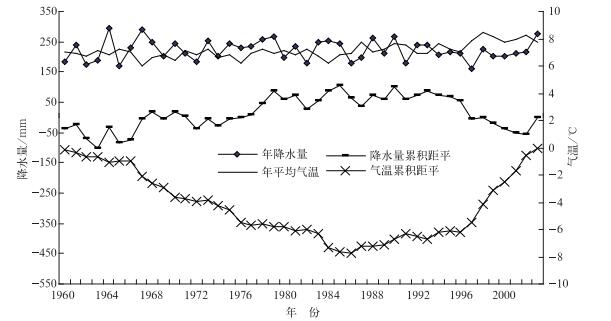
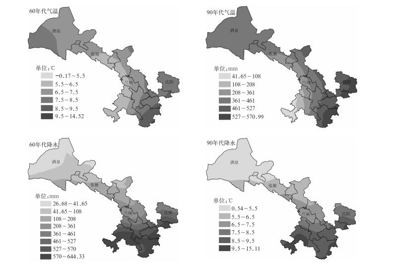
摘要: 对甘肃省1960—2003年气温和降水序列进行长期变化趋势分析的基础上,根据地统计学原理对20世纪60年代和90年代甘肃省气温和降水时空演变特征进行了探讨。结果表明:气温序列具有显著上升趋势;降水序列具有减少趋势,但不显著。20世纪60年代和90年代气温由空间自相关引起的空间变异分别占总空间变异的25%和32%,60年代和90年代降水由空间自相关引起的空间变异性分别占78%和80%。比较两个年代气温和降水的空间格局变化,甘肃省绝大部分地区气温升高,包括陇南南部、陇东、陇中东部、河西走廊平原区、北山山区的局部地区和祁连山区部分地区;除河西走廊平原区局部地区、北山中山区降水量有所增加外,大部分地区降水量有所减少。Abstract: Temporal features of annual temperature and precipitation at 28 stations in Gansu Province from 1960 to 2003 are analyzed using nonparametric Mann Kendall method and the accumulated departure approach. Spatial characteristics of these two variables in the 1960s and 1990s are detected using geostatistical method. It shows that the annual temperature has a significant increasing trend, while the precipitation has an insignificant decreasing trend at 0.1 significance level. Annual temperature experienced with low level from the 1960s to mid 1980s and with high level from 1986 to 2003, and abundant precipitation occurred in the 1970s and relative low in the 1990s at 0.05 significance level. Gaussian model is the best theoretical model for temperature semivariogram. 25% and 32% of total spatial variability in temperature is resulted from spatial autocorrelation in the 1960s and 1990s. Spherical model is the best model for precipitation semivariogram. The incidence of precipitation in the 1990s is smaller than that in the 1960s, and smaller than those of temperature in both 1960s and 1990s, indicating that the effects of local micro climate such as topography and slopes on precipitation is greater than those on temperature. 78% and 80% of total spatial variability in precipitation is attributed to spatial autocorrelation in the 1960s and 1990s, showing intensive spatial autocorrelation in precipitation in Gansu Province. Compared with the spatial variations from 1960s to 1990s, temperature increased in most of the regions, including the south of Longnan, Longdong, the east of Longzhong, Hexi Corridor plain, local area of Beishan middle mountains and the Qilian Mountains area. Precipitation tended to decrease in most of the regions, especially in Longnan area and Gannan Plateau area, while the situations in some local areas of Hexi Corridor plain and Beishan middle mountains area are on the contrary.
-
表 1 气温和降水半变异函数不同理论模型的比较
Table 1 Comparison of different theoretical models for temperature and precipitation experimental semivariograms

表 2 气温和降水半变异函数理论模型的相关参数及其精度检验
Table 2 Model paramenters and precision tests for temperature and precipitation experimental semivariograms

表 3 气温、降水序列OK法与COK法比较
Table 3 Comparison of Ordinary Kriging and Coordinary Kriging for temperature and precipitation time series

-
[1] 李小玉, 宋冬梅, 肖笃宁.石羊河下游民勤绿洲地下水矿化度的时空变异.地理学报, 2005, 60(2):319-327. http://www.cnki.com.cn/Article/CJFDTOTAL-DLXB20050200F.htm [2] Holawe F, Dutter R. Geostatistical study of precipitation series in Austria: Time and space. J Hydrol, 1999, 219(1-2): 70-82. doi: 10.1016/S0022-1694(99)00046-3 [3] Deluís M, Raventós, González-Hidalgo C, et al. Spatial analysis of rainfall trends in the region of Valencia(East Spain). International ournal of Climatology, 2000, 20: 1451-1469. doi: 10.1002/(ISSN)1097-0088 [4] 王政权.地统计学及其在生态学中的应用.北京:科学出版社, 1999. [5] Xu Z X, Chen Y N, IA Y. Impact of climate change on water resources in the Tarim River basin. Water Resource Management, 2004, 18(5): 439-458. doi: 10.1023/B:WARM.0000049142.95583.98 [6] 刘春蓁, 刘志雨, 谢正辉.近50年海河流域径流的变化趋势研究.应用气象学报, 2004, 15(4):385-393. http://qk.cams.cma.gov.cn/jams/ch/reader/view_abstract.aspx?file_no=20040448&flag=1 [7] 魏凤英.现代气候统计诊断与预测技术.北京:气象出版社, 1999. [8] 魏凤英.气候统计诊断与预测方法研究进展——纪念中国气象科学研究院成立50周年.应用气象学报, 2006, 17(6):736-742. http://qk.cams.cma.gov.cn/jams/ch/reader/view_abstract.aspx?file_no=200606122&flag=1 [9] 魏凤英, 曹鸿兴.地统计学分析技术及其在气象中的适用性.气象, 2002, 28(12):3-5. http://www.cnki.com.cn/Article/CJFDTOTAL-QXXX200212000.htm [10] 庄立伟, 王石立.东北地区逐日气象要素的空间插值方法应用研究.应用气象学报, 2003, 14(5):605-615. http://qk.cams.cma.gov.cn/jams/ch/reader/view_abstract.aspx?file_no=20030575&flag=1 [11] 岳文泽, 徐建华, 徐丽华.基于地统计方法的气候要素空间插值研究.高原气象, 2005, 24(6):974-980. http://www.cnki.com.cn/Article/CJFDTOTAL-GYQX200506017.htm [12] Susan M S, Stuart E M, Mitchel P M, et al. Climate spatial variability and data resolution in a semi-arid watershed, south-eastern Arizona. Journal of Arid Environments, 2003, 64(4): 667-686. https://www.researchgate.net/publication/248568000_Climate_spatial_variability_and_data_resolution_in_a_semi-arid_watershed_south-eastern_Arizona [13] Ersahin S. Comparing ordinary kriging and cokriging to estimate infiltration rate. Soil Science Society of America ournal, 2003, 67(6): 1848-1855. doi: 10.2136/sssaj2003.1848 [14] 闫金凤, 陈曦, 罗格平, 等.干旱区绿洲地下水水位时空变异性对土地覆被变化的响应.科学通报, 2006, 51(增刊):42-48 http://www.cnki.com.cn/Article/CJFDTOTAL-KXTB2006S1007.htm [15] 张存杰, 郭妮.祁连山区近40年气候变化特征.气象, 2002, 28(12):33-39. http://www.cnki.com.cn/Article/CJFDTOTAL-QXXX200212008.htm [16] 蓝永超, 康尔泗, 仵彦卿, 等.气候变化对河西内陆干旱区出山径流的影响.冰川冻土, 2001, 23(3):276-282. http://www.cnki.com.cn/Article/CJFDTOTAL-BCDT200103012.htm [17] 魏锋, 丁裕国, 白虎志, 等.甘肃省近40a汛期无雨日数异常的气候特征分析.气象科学, 2005, 25(3):249-256. http://www.cnki.com.cn/Article/CJFDTOTAL-QXKX200503004.htm [18] 孙旭映.甘肃河东地区降水特征及天气系统分型.干旱区资源与环境, 2006, 20(4):35-39. http://www.cnki.com.cn/Article/CJFDTOTAL-GHZH200604007.htm [19] 韦志刚, 董文杰, 惠小英.中国西北地区降水的演变趋势和年际变化.气象学报, 2000, 58(2):234-243. http://www.cnki.com.cn/Article/CJFDTOTAL-QXXB200002010.htm [20] 宋连春, 张存杰.20世纪西北地区降水量变化特征.冰川冻土, 2003, 25(2):143-147. http://www.cnki.com.cn/Article/CJFDTOTAL-BCDT200302004.htm -


 设为首页
设为首页 加入收藏
加入收藏


 下载:
下载:

