登陆台风环流内的一次中尺度强对流过程
A Strong Mesoscale Convective Process in Landfalling Typhoon
-
摘要: 2005年05号台风“海棠”登陆福建后,在外围云系里有1个明显发展的中尺度对流云团经过温州东部及北部地区,引起了强降水。通过分析这次中尺度对流系统的环流形势,得到该次中尺度对流系统的垂直结构特征,并对中尺度强对流系统的形成和发展机制进行研究。结果表明:台风东南急流在温州附近冷区边缘处低层受地形影响发生强烈辐合引起的垂直上升运动和冷暖空气相汇产生的对流不稳定性是台风环流内中尺度对流系统的主要形成机制;对流系统在暖湿空气和冷空气中心交汇处发展,西北侧的冷空气堆迫使暖湿东南气流沿西北倾斜的等熵面爬升,有利于倾斜对流系统的发展;低层条件不稳定区与中层条件对称不稳定区叠加,产生对流对称不稳定,在湿等熵面倾斜引起的涡旋发展的强迫机制下在中层产生范围较广的倾斜上升对流;由于等熵面的倾斜,大气水平风垂直切变或湿斜压性增加,进一步加强涡度的发展,使得对流系统向西北方向发展;另外,源于东南沿海,由台风东南气流输送的水汽为特大暴雨的产生提供了有利的热力条件。Abstract: The fifth typhoon named Haitang landfalls in Fujian in 2005, and then moved northwestward. During this moving, there is a mesoscale convective cloud increasing markedly, within the periphery cloud cinctures of typhoon connecting with tropic convergence cinctures. Moreover, the mesoscale convective cloud passes the east and the north of Wenzhou, and causes heavy rainfalls in these places. This case indicates clearly that a strong mesoscale convective system can be developed under appropriate circumstance, even if the landing typhoon is abating. Severe weather can be resulted from the strong mesoscale convective system, even more dangerous than typhoon. Therefore, principles of strong mesoscale convective system in landing typhoon should be discussed on the structure and evolution of MCS to forecast rainstorm caused by the landfalling typhoon better in the future.The evolution of MCS in landfalling typhoon can be seen through the nephogram and radar reflecting data. Research on the structure of MCS by the NCEP data shows that the MCS along landing typhoon is gradient in maturation period.The synoptic situation, occurring two hours before MCS formed, could be analyzed by NCEP data. Then the formation of MCS is found attributing to two factors. One factor is the convective instability. The profound southeast current of typhoon transports the warm and wet air into the cold area in the north of Wenzhou. In this situation, the cold air is meeting the warm and wet air. So the convective instability is caused and increasing gradually. Meanwhile, the convergence of air is coming out in the influence of the special landform of the north of Wenzhou. However, the air will be moving upward vertically, which is caused by this convergence. So the vertical upward of air is the other factor.Using the theory of slantwise vorticity development and moist potential vorticity, the evaluative theory of this strong mesoscale convective system is obtained. The evolution of MCS could be shown by looking into the situation of MCS in maturation. MCS begins to develop from the area where the cold air pile meets the warm air. In this region, there is slantwise moist isentropic surface. The northwest cold pile forces warm air to climb up along the slantwise moist isentropic surface, so the cyclonic vorticity develops. Because of the interaction between the condition instability at low level and the condition-symmetric instability at middle layer, the convective-symmetric instability develops. In this circumstance, the stream slantwise and ascend at middle layer is widely formed by the vorticity caused by the slantwise isentropic surface. On the other hand, the increasing in vertical shear of horizontal wind or enhancing in moist baroclinity, because of the slantwise of moist isentropic surface, results in intensifying the development of vertical vorticity and stretching towards northwest of MCS.
-
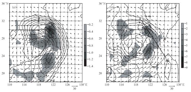
图 2 2005年7月20日02:00的850 hPa 上各物理量分布
(虚椭圆表示暴雨区) (a) 等风速场(等值线,单位: m/s) 和垂直速度w场 (阴影为w≤-0.2 Pa/s的区域),(b) 温度场(等值线,单位: ℃) 和水汽通量散度场 (阴影,单位: 10-7g·s-1· hPa-1·cm-2)
Fig. 2 Synoptic situation at 850 hPa at 02:00 20 Jul 2005
(dashed ellipse represents the area of rain) (a) horizontal wind speed (isoline, unit: m/s) and vertical speed w (shaded area is for vertical wind speed smaller than-0.2 Pa/s), (b) temperature (isoline, unit: ℃) and moisture flux divergence (shaded area, unit: 10-7g·s-1·cm-2)
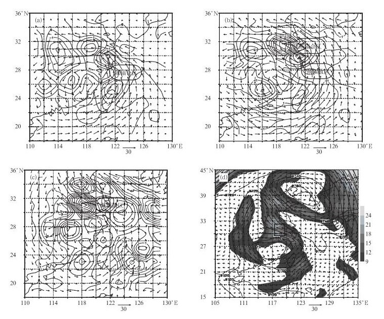
图 3 2005年7月20日02:00各层以风矢量为背景各物理量分布
(a) 850 hPa 散度场 (单位: 10-5s-1), (b) 600 hPa 散度场 (单位: 10-5s-1), (c) 300 hPa (单位: 10-5s-1), (d) 300 hPa 位势高度场 (等值线,单位: gpm) 和等风速场 (阴影,单位: m/s; 方框表示图 3c中的强辐散区)
Fig. 3 Synoptic situation at different leveks at 02:00 20 Jul 2005
(a) divergence at 850 hPa (unit: 10-5s-1), (b) divergence at 600 hPa (unit: 10-5s-1), (c) divergence at 300 hPa (unit:10-5s-1), (d) geopotential height (isoline, unit:gpm) and horizontal wind speed at 300 hPa (shaded, unit: m/s; pane represents the strong divergence area in Fig.3c)
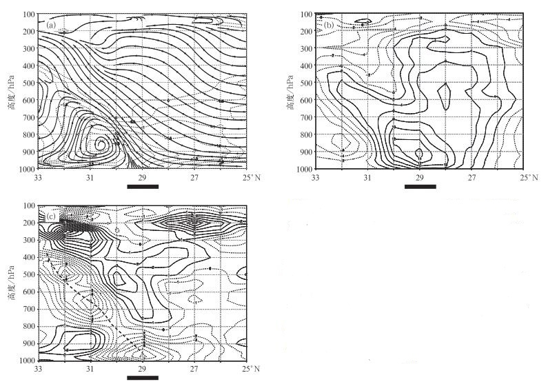
图 4 2005年7月20日02:00沿图 2b中AB剖面的各物理量分布(

(a) 流场 (实线) 和温度距平场 (虚线表示温度距平≤0℃), (b) 涡度场分布 (实线表示正涡度,虚线表示负涡度,单位:10-5s-1), (c) 散度场分布 (实线表示辐散区,细虚线表示辐合区,粗虚线为强辐合中心轴线,单位:10-5s-1)
Fig. 4 Vertical cross sections along line AB in Fig.2b for synoptic situation at 02:00 20 Jul 2005 (

(a) streamlines (solid line) and temperature dispatch (dashed line is for the area that temperature dispatch amsller than 0 ℃), (b) vorticity (solid line represents positive, dash line represents negative, unit: 10-5s-1), (c) divergence (solid line represents divergence, thin dashed line represents comvergence, thick dashed line represents the axes of center of convergence, unit: 10-5s-1 )
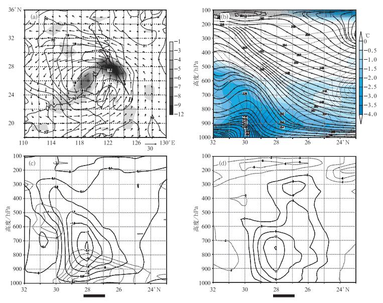
图 5 2005年7月19日20:00各物理量分布 (

(a) 850 hPa风矢量场、温度 (等值线,单位:℃) 和水汽通量散度(阴影,单位:10-7g·s-1·hPa-1·cm-2), (b) 沿图 5a 中CD剖面的流场、相当位温 (长虚线,单位:K) 和温度距平场 (阴影表示≤0 ℃的区域), (c) 沿图 5a中CD剖面的散度场 (虚线,单位:10-5s-1) 和垂直速度 (实线,单位:Pa/s ), (d) 沿图 5a中CD剖面的涡度场 (实线表示正涡度,虚线表示负涡度,单位:10-5s-1)
Fig. 5 Synopic situation at 20:00 19 Jul 2005
(a) wind vector, temperature (isoline, unit: ℃) and moisture flux divergence (shaded area, unit: 10-7g·s-1·hPa-1·cm-2) at 850 hPa, (b) vertical cross sections along CD in Fig. 5a for streamlines (solid line), equivalent potential temperature (long-dash line, unit: K) and temperature dispatch (shaded area represents temperature dispatch smaller than 0℃), (c) vertical cross sections along line CD in Fig. 5a for divergence (dash line, unit: 10-5s-1) and vertical speed w (solid line, unit: Pa/s), (d) vertical cross sections along line CD in Fig. 5a for vorticity (solid line represents positive, dashed line represents negative, unit: 10-5s-1)
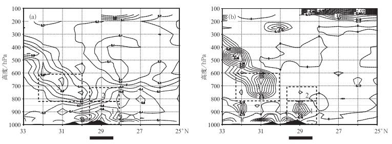
图 7 2005年7月20日02:00沿图AB剖面的MPV1 (a) , MPV2 (b) 的分布
(单位:PVU; 虚线为负值,实线为非负值)
Fig. 7 Vertical cross sections along line AB in Fig. 2b for MPV1 (a) and MPV2 (b) at 02:00 20 Jul 2005
(unit: PVU; dash line represents negative, solid line represents postive)
-
[1] 陈玉林,周军,马奋华.登陆我国台风研究概述.气象科学,2005,25(3): 319-329. http://www.cnki.com.cn/Article/CJFDTOTAL-QXKX200503014.htm [2] 陈联寿,罗哲贤,李英.登陆热带气旋研究的进展.气象学报,2004,62(5): 541-549. http://www.cnki.com.cn/Article/CJFDTOTAL-QXXB200405003.htm [3] 陈联寿,孟智勇.我国热带气旋研究十年进展.大气科学,2001,25(3): 420-432. http://www.cnki.com.cn/Article/CJFDTOTAL-DQXK200103012.htm [4] 郑庆林,吴军.我国东南海岸线分布对9216号台风暴雨增幅影响的数值研究.热带气象学报,1996,12(4): 304-312. http://www.cnki.com.cn/Article/CJFDTOTAL-RDQX604.002.htm [5] 段丽,陈联寿.热带风暴“菲特” (0114) 特大暴雨的诊断研究.大气科学,2005,29(3): 343-353. http://www.cnki.com.cn/Article/CJFDTOTAL-DQXK200503001.htm [6] 张伟,张庆红.登陆台风中的中尺度对流系统的数值研究.北京大学学报,2004,40(1): 73-79. http://www.cnki.com.cn/Article/CJFDTOTAL-BJDZ200401010.htm [7] Zhang Qinghong,Lau Kai-Hon,Wang Hongqing,et al. Numerical simulation on mesoscale convective system along Meiyu front in Southern China. Chinese Science Bulletin,2000,45: 2093-2096. doi: 10.1007/BF03183534 [8] 薛根元,诸晓明,朱健.0505号台风“海棠”灾害的初步诊断研究.科技导报,2005,23(10): 30-34. http://www.cnki.com.cn/Article/CJFDTOTAL-KJDB200510008.htm [9] 王忠东,杜友强,郑锋.0505号台风“海棠”特大暴雨成因分析.浙江气象,2006,27(2): 16-20. http://www.cnki.com.cn/Article/CJFDTOTAL-ZJQX200602003.htm [10] 程艳红,陆汉城.强迫流与不稳定流的相互作用.大气科学,2006,30(4): 609-618. http://www.cnki.com.cn/Article/CJFDTOTAL-DQXK200604006.htm [11] 王建中,马淑芬.位涡在暴雨成因分析中的应用.应用气象学报,1996,7(1): 19-26. http://qikan.camscma.cn/jams/ch/reader/view_abstract.aspx?file_no=19960103&flag=1 [12] 蒙伟光,王安宇.华南暴雨中尺度对流系统的形成及湿位涡分析.大气科学,2004,28(3): 330-341. http://www.cnki.com.cn/Article/CJFDTOTAL-DQXK200403001.htm [13] 吴国雄,蔡雅萍,唐晓箐.湿位涡和倾斜涡度发展.气象学报,1995,53(4): 387-405. http://www.cnki.com.cn/Article/CJFDTOTAL-QXXB504.001.htm [14] 陆汉城.中尺度天气原理和预报.北京:气象出版社,2000. [15] 寿绍文,李耀辉,范可.暴雨中尺度气旋发展的等熵面位涡分析.气象学报,2001,59(3): 321-334. http://www.cnki.com.cn/Article/CJFDTOTAL-QXXB200105006.htm [16] 程艳红,陆汉城.对流对称不稳定的发展演变和环流特征.热带气象学报,2006,22(3): 253-258. http://www.cnki.com.cn/Article/CJFDTOTAL-RDQX200603007.htm -


 设为首页
设为首页 加入收藏
加入收藏


 下载:
下载:
