
 设为首页
设为首页 加入收藏
加入收藏

青岛奥帆赛高分辨率数值模式系统研制与应用
The Development of High Resolution Numerical Model System for Qingdao Olympic Sailing Competition
-
摘要: 该文初步建立了青岛奥帆赛高分辨率数值模式系统(包括预报模式和释用模式)。预报模式基于Weather Research & Forecast(WRF)模式V3.0,模式设计为网格数60×50×38,水平分辨率500 m。在IBM小型机上用8个线程作15 h预报所需机时约为1 h 20 min,可满足实时业务预报需要。利用高分辨率边界层模式和城市小区尺度模式对该预报结果进行了动力释用(水平分辨率分别为100 m和10 m)。该模式系统于2008年夏季进行了实时运行试验,模式产品在北京奥运气象服务中心青岛分中心使用。结果表明:该模式系统有较强的稳定性和实用性,对城市热岛、海陆风、地形及建筑物影响等局地环流特征有较好的模拟效果。数值试验分析表明:城市化引起城市热岛效应,增大了海陆温差,使海风加强;城市建筑物拖曳作用使风速减小,从而使海风推进速度减缓;精细下垫面资料的引入对海风等局地环流高分辨率数值模拟至关重要。
-
关键词:
- 青岛奥帆赛;
- 高分辨率数值模式系统;
- WRF模式;
- 动力释用;
- 城市化
Abstract: In order to improve the skill of weather forecast and provide better meteorological service for Olympic Sailing Competition, high resolution numerical model system for Qingdao Olympic Sailing Competition (including forecast model and interpretation models) is developed.Based on Weather Research & Forecast (WRF) Model Version 3.0, a forecast model is set up with gird of 60×50×38 and horizontal resolution of 500 m. It takes about 1 hour and 20 minutes to produce 15-hour forecast on an IBM computer with 8 threads, which meets the requirement of operational forecast. Dynamic interpretations to the forecast results are carried out with the aid of a high resolution Planetary Boundary Layer Model (PBLM) and an Urban Neighborhood Scale Model (UNSM) (with the horizontal resolution of 100 m and 10 m respectively).This model system runs continuously during the summer of 2008, and the model products are used in Qingdao Branch of Beijing Olympic Meteorological Service Center. Results show that, the model system is robust and practical, and performs quite well on the simulation of urban heat island and local circulations (e.g., sea-land breeze and terrain/building effects). Analyses of numerical cases indicate that urbanization leads to urban heat island, increases sea-land temperature difference, and strengthens sea-breeze. Mean-while the drag effect of urban building decreases the wind speed, and slows down the advance of sea-breeze. The introducing of fine underlying surface data is critical to high resolution numerical simulation of local circulations (e.g., sea-breeze).The dynamic interpretation to the forecast results with the aid of a high resolution PBLM with the horizontal resolution of 100 m indicates that, generally PBLM could simulate the wind field and the effects of surrounding terrain very well. The PBLM results are consistent with the observations from buoys and automatic weather stations, and have similar charaeteristies with Lidar observations. Further fine-scale dnamic interpretation in terms of UNSM with the horizontal resolution of 10 meters shows that UNSM could well simulate the wind in urban blocks. So the dynamic interpretations based on the terrain-following coordinate PBLM and the build-aware UNSM are effective to simulate the effect of local terrain and buildings on the wind in interest venues. -
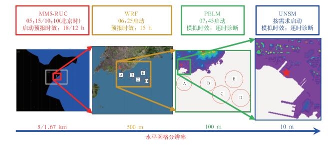
图 1 青岛奥帆赛高分辨率数值模式系统示意图
Fig. 1 Sketch of high-resolution numerical model system for Qingdao Olympic Sailing Competition
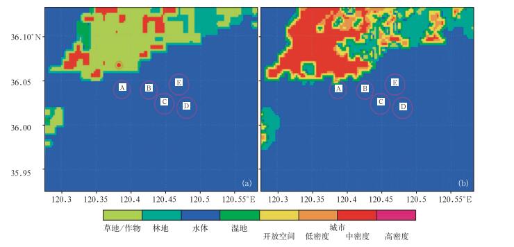
图 2 青岛市土地利用与土地租盖
(a) USGS数据,(b) 本研究制作的分类数据
Fig. 2 Land use and land cover in Qingdao
(a) USGS data, (b) the data from this study
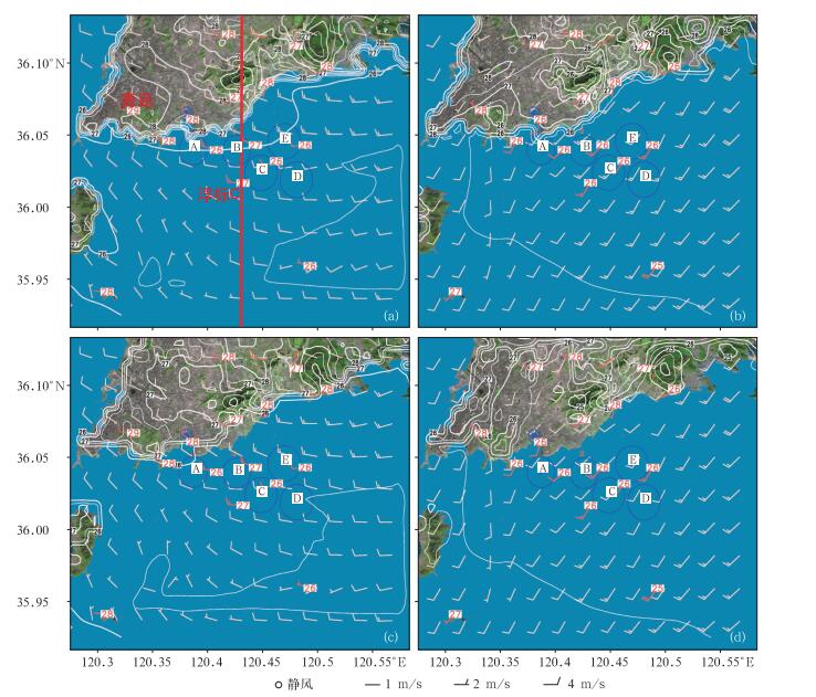
图 3 2008年8月18日WRF模拟10 m风场 (粉色风羽)、2 m气温(白色等值线)及观测10 m风场 (红色风羽), 2 m气温 (红色数值) 分布
(a) 14:00, 本研究制作的地表分类数据, (b) 17:00, 本研究制作的地表分类数据,(c)14:00, USGS数据,(d) 17:00, USGS数据
Fig. 3 10 m wind (pink barbs for simulated, red barbs for observed〉and 2 m temperature (white isolines for simulated, red numbers for observed) from WRF simulation and observation on 18 August 2008
(a) 14:00, data from the current study, (b) 17:00, data from the current study, (c) 14:00, USGS daia, (d) 17:00, USGS data
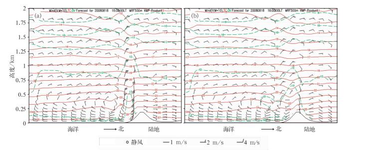
图 4 2008年8月18日16:00 WRF模拟结果沿图 3a中红色实线的南北向垂直剖面图
图中黑色风羽为v及w×10;红色实线为气温,单位:℃;绿色虚线为比湿,单位:g·kg-1)(a) 本研究制作的地表分类数据,(b) USGS数据
Fig. 4 Section plane of wind, temperature and specific humidity along the red line in Fig. 3a from WRF simulation at 16:00 18 August 2008
((a) data from the current study, (b) USGS data (black barb is v and w×10, red solid line is temperature, unit: ℃; green dashed line is specific humidity, unit: g·kg-1)
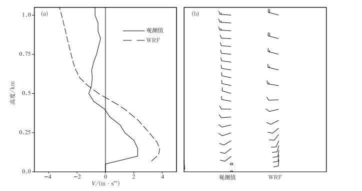
图 5 2008年8月18日19:00青岛站模拟与观测风廓线比较
(a) 风速兩北方向分量,(b) 水平风矢
Fig. 5 Wind profilers at Qingdao station from simulation and observation at 19:00 18 August 2008
(a) meridional wind speed, (b) horizontal wind vector

图 6 青岛奥帆赛场 (蓝色圆圈A~E) 周边地区地形高度 (填色,单位:m) 及10 m高度风场分布图 (黑色风羽及绿色等值线为PBLM模拟的风场及水平风速,红色风羽及数值为浮标和自动站观测的风场及水平风速,风速单位:m·s-1)
(a)2008年8月15日09:00, (b)2008年8月15日ll:00, (c)2008年8月15日12:00, (d)2008年8月18日12:00
Fig. 6 Terrain around Qingdao Olympic sailing venue and wind field at the height of 10 m (black barbs for simulated wind by PBLM, green isolines for horizontal wind speed; red barbs for observed wind, red numbers for observed wind speed; unit of wind speed is m·s-1)
(a) 09:00 15 August 2008, (b) 11:00 15 August 2008, (c) 12:00 15 August 2008, (d) 12:00 18 August 2008
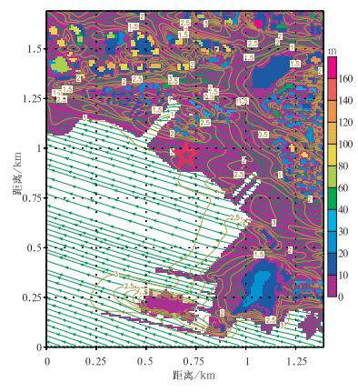
图 7 青岛奥林匹克主題公园(红色五角星) 周边地区地形与建筑物高度 (填色,单位:m) 及UNSM模拟的2008年8月9日20:00 10 m高度风场 (流线及水平风速等值线,单位:m·s-1) 分布图
Fig. 7 Terrain and building height (shaded, unit:m) around Qingdao Olympic Theme Park (red star), and 10 m wind (streamlines and isolines, unit:m·s-1) at 20:00 9 August 2008 from UNSM simulation
表 1 WRF模拟与观测比较统计呈列表
Table 1 Comparison of the WRF-simulated and observed surface variables

-
[1] 洪光, 徐晓亮.青岛奥帆赛期间天气气候背景分析.应用气象学报, 2006, 17(增刊):54-59 http://www.cnki.com.cn/Article/CJFDTOTAL-YYQX2006S1007.htm [2] 王建捷, 王迎春, 崔波, 等.北京地区中尺度非静力数值预报系统的开发与实时预报应用.应用气象学报, 1999, 10(4):385-393 http://qikan.camscma.cn/jams/ch/reader/view_abstract.aspx?file_no=19990497&flag=1 [3] Chen Min, Huang Xiangyu. Digital filter initialization for MM5. Mon Wea Rev, 2006, 134:1222-1236 https://www.researchgate.net/publication/242099111_Digital_Filter_Initialization_for_MM5 [4] Chen Fei, Tewari Mukul, Miao Shiguang, et al. Challenges in Developing Advanced Urban Parameterization Schemes for the Community WRF Model∥AMS Seventh Symposium on the Urban Environment. San Diego, CA, USA, 2007 [5] Miao Shiguang, Chen Fei. Formation of horizontal convective rolls in urban areas. Atmos Res, 2008, 89(3):298-304 http://www.sciencedirect.com/science/article/pii/S0169809508000537 [6] Miao Shiguang, Chen Fei, LeMone M A, et al. An observational and modeling study of characteristics of urban heat island and boundary layer structures in Beijing. J App Meteor Climatology, 2009, 48(3):484-501 http://www.researchgate.net/publication/238428503_An_Observational_and_Modeling_Study_of_Characteristics_of_Urban_Heat_Island_and_Boundary_Layer_Structures_in_Beijing [7] 李敏, 蒋维楣, 张宁, 等.由泄洪水流引起的水舌风现象的数值模拟分析.空气动力学学报, 2003, 21(4):408-416 http://www.cnki.com.cn/Article/CJFDTOTAL-KQDX200304004.htm [8] 苗世光, 蒋维楣, 王晓云, 等.城市小区气象与污染扩散数值模式建立的研究.环境科学学报, 2002, 22(4):478-483 http://www.cnki.com.cn/Article/CJFDTOTAL-HJXX200204012.htm [9] 苗世光, 张朝林, 江晓燕, 等.城市小区气象条件与污染扩散精细预报研究.环境科学学报, 2006, 26(10):1729-1736 http://www.cnki.com.cn/Article/CJFDTOTAL-HJXX200610027.htm [10] 蒋维楣, 王咏薇, 刘罡, 等.多尺度城市边界层数值模式系统.南京大学学报 (自然科学版), 2007, 43(3):221-237 http://www.cnki.com.cn/Article/CJFDTOTAL-NJDZ200703000.htm [11] 马艳, 杨育强, 高荣珍, 等.局地资料同化在2008青岛奥帆赛风场预报中的应用.气象, 2008, 34(专刊):212-218 http://www.cnki.com.cn/Article/CJFDTOTAL-QXXX2008S1038.htm [12] Skamarock W C, Klemp J B, Dudhia J, et al. A Description of the Advanced Research WRF Version 2. NCAR Tech Note, NCAR, TN-468+STR, 2005 [13] Grell G A, Dudhia J, Stauffer D R. A Description of the fifth-generation Penn State/NCAR Mesoscale Model (MM5). NCAR Tech Note, NCAR, TN-398+STR, 1994 [14] Pielke R A, Pearce R P. Mesoscale Modeling of the Atmosphere. Boston, Massachusetts:American Meteorological Society, 1994 [15] Jiang Weimei, Zhou Mi, Xu Min, et al. Study on development and application of regional PBL numerical model. Bound Layer Meteor, 2002, 104:491-503 doi: 10.1023/A:1016504113098 [16] Liu Zhishen, Wu Dong, Zhang Kailin, et al. A mobile incoherent Mie-Rayleigh Doppler wind Lidar with a single frequency and tunable operation of an injection Nd:YAG laser. Science in China (Series E), 2003, 46(3):309-317 doi: 10.1360/03ye9034 [17] Miao Shiguang, Jiang Weimei, Wang Xiaoyun, et al. Impact assessment of urban meteorology and the atmospheric environment using urban sub-domain planning. Bound Layer Meteor, 2006, 118(1):133-150. doi: 10.1007/s10546-005-5292-4 -

 下载:
下载:
计量
- 摘要浏览量: 4963
- HTML全文浏览量: 741
- PDF下载量: 2054
- 被引次数: 0
