径流量Z指数与Palmer指数对河西干旱的监测
The Drought Monitoring in Hexi Area Using the Runoff-denoted Z Index and the Palmer Index
-
摘要: 利用河西内陆河水文代表站1959-2004年逐月径流量资料、内陆河流域灌溉区1949-2001年耕地面积及代表站1961-2005年的气象资料, 通过对径流量进行正态化处理来确定径流量Z指数, 并以径流量Z指数作为径流干旱指数, 对旱涝等级进行划分; 考虑径流量Z指数的旱涝等级与农业灌溉用水实际情况之间的关系, 给出了径流量Z指数的灌溉指标。将径流量转化为降水量, 改进Palmer旱度模式, 且在作改进后, 又将潜在蒸散量的计算法由利用桑斯威特公式改为利用彭曼公式。结果表明:将径流量考虑到Palmer干旱指数中并改变蒸散量的算法, 使得该指数对河西灌溉区干旱情况的监测均有所改善。对照河西地区的干旱事件, 径流量Z指数监测到的干旱情况, 比Palmer干旱指数改进前、后监测到的干旱情况效果更佳。径流量Z指数能更真实地反映河西灌溉区干旱状况。
-
关键词:
- 河西灌溉区;
- 内陆河径流量;
- 径流量Z指数;
- Palmer干旱指数
Abstract: Hexi is a typical irrigation agricultural area, it is impossible to grow crops based on the natural precipitation, which is only 100-150 mm every year on average. The runoff of inland river is the main water resource for agriculture. That means the high/low runoff is the main determination of dry/wet condition in the target area. Therefore, runoff is considered as the variable to define a Z-index in order to monitor the drought in Hexi irrigation area. Being the Palmer drought severity index-PDSI has been widely applied in the world since the 1960s. In addition, the PDSI is also widely used in drought assessment, comparison and its spatial/temporal distributions analysis. So PDSI is selected to compare with the runoff-denoted Z index in the drought monitoring in Hexi area.The monthly runoff data from hydrological representative station, the tilth area and the meteorological data from representative station of inland river in Hexi area are utilized. A runoff-denoted drought index, the runoff-denoted Z index is established by processing runoff normally. Dry and wet grades are also divided using this index. Considering the relationship between the dry/wet grades and the actual situation of agricultural irrigation, the irrigation grades of Z index are obtained. The precipitation is derived from runoff to revise the Palmer drought severity index. In addition, Penman method is adopted replacing the Thornthwaite method to improve the potential evaporation calculating scheme. Results show that drought monitoring is improved when the runoff is calculated in Palmer drought severity index and the calculation method of potential evaporation is changed. Based on the drought events in Hexi area, the monitoring effect of the Z index is better than the Palmer drought severity index. So it can be concluded that the drought monitored by the runoff-denoted Z index is closer to the actual status in Hexi irrigation area. -
表 1 径流量Z指数旱涝等级标准
Table 1 Runoff-denoted Z index dry/wet grades

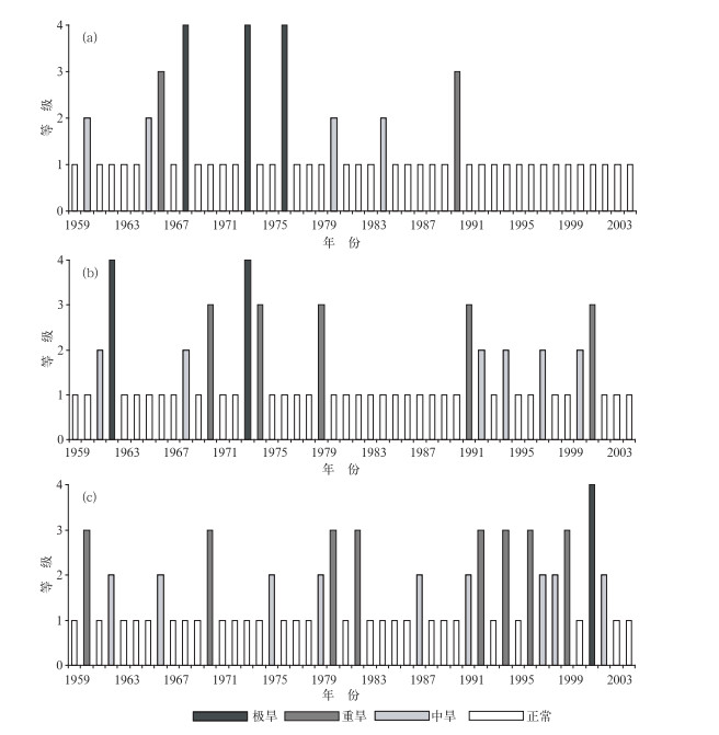
表 2 3种方案计算得到的PDSI、径流量Z指数所指示的干旱等级及其与实际旱情的对比
Table 2 The dry grades calculated by the PDSI with three schemes and runoff-denoted Z index and their comparison to actual drought situation

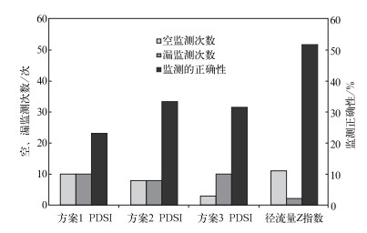
表 3 3种方案计算得到的PDSI以及径流量Z指数漏监测的干旱年份
Table 3 The excluding drought years by using the PDSI with three schemes and runoff-denoted Z index to monitor

-
[1] 胡天清.黑河春末初夏径流量与气象要素的关系.高原气象, 1988, 7(4):374-376. http://www.cnki.com.cn/Article/CJFDTOTAL-GYQX198804008.htm [2] 李栋梁, 陈丽萍.河西走廊黑河流量的气候特征及其预报.应用气象学报, 1991, 2(3):319-324. http://qikan.camscma.cn/jams/ch/reader/view_abstract.aspx?file_no=19910343&flag=1 [3] 孙国武, 刘晓东, 陈葆德.夏季青藏高原地面热源对黄河上游流量及径流的影响.应用气象学报, 1993, 4(1):22-29. http://qikan.camscma.cn/jams/ch/reader/view_abstract.aspx?file_no=19930108&flag=1 [4] 袁玉江, 桑修诚.甘肃省河西地区气候对流量影响的初步分析.高原气象, 1998, 17(2):211-216. http://www.cnki.com.cn/Article/CJFDTOTAL-GYQX802.012.htm [5] 冯建英.河西内陆河春季流量变化特征的分析和预测.甘肃气象, 1998, 16(4):38-41. http://www.cnki.com.cn/Article/CJFDTOTAL-GSQX804.009.htm [6] 王劲松, 冯建英.甘肃省河西地区径流量干旱指数初探.气象, 2000, 26(6):3-7. http://www.cnki.com.cn/Article/CJFDTOTAL-QXXX200006000.htm [7] 鞠笑生, 杨贤为, 陈丽娟, 等.我国单站旱涝指标确定和区域旱涝级别划分的研究.应用气象学报, 1997, 8(1):26-32. http://qikan.camscma.cn/jams/ch/reader/view_abstract.aspx?file_no=19970104&flag=1 [8] 张存杰, 王宝灵, 刘德祥, 等.西北地区大气旱涝指标的研究.高原气象, 1998, 17(4):381-389. http://www.cnki.com.cn/Article/CJFDTOTAL-GYQX804.005.htm [9] 邹旭恺, 张强.近半个世纪我国干旱变化的初步研究.应用气象学报, 2008, 19(6):679-687. http://www.cnki.com.cn/Article/CJFDTOTAL-YYQX200806006.htm [10] 王越, 江志红, 张强, 等.用Palmer湿润指数作西北东部冬小麦旱涝评估.应用气象学报, 2008, 19(3):342-349. http://qikan.camscma.cn/jams/ch/reader/view_abstract.aspx?file_no=20080356&flag=1 [11] 郭安红, 刘巍巍, 安顺清, 等.基于改进失水模式和增加建模站点的Palmer旱度模式.应用气象学报, 2008, 19(4):502-506. http://qikan.camscma.cn/jams/ch/reader/view_abstract.aspx?file_no=20080415&flag=1 [12] 安顺清, 邢久星.修正的帕默尔干旱指数及其应用.气象, 1985, 11(12):17-19. http://www.cnki.com.cn/Article/CJFDTOTAL-QXXX198512005.htm [13] 安顺清, 邢久星.帕尔默旱度模式的修正.气象科学研究院院刊, 1986, 1(1):75-82. http://www.cnki.com.cn/Article/CJFDTOTAL-YYQX198601009.htm [14] Thornthwaite C W.An approach toward a rational classification of climate.Geogr Rev, 1948, 38 :55-94. doi: 10.2307/210739 [15] Penman H L.Evaporation over the British Isles.Quar J Royal Meteor Soc, 1950, 76 :372-383. doi: 10.1002/(ISSN)1477-870X [16] 屠其璞, 王俊德, 丁裕国, 等.气象应用概率统计学.北京:气象出版社, 1984 :41-42;203-206. [17] 张新时.植被的PE (可能蒸散) 指标与植被-气候分类 (1).植物生态学与植物学学报, 1989, 13(1):1-9. http://www.cnki.com.cn/Article/CJFDTOTAL-ZWSB198901000.htm [18] 尚宗波.中国水分状况对全球气候变化的敏感性分析.生态学报, 2001, 21(4):528-537. http://www.cnki.com.cn/Article/CJFDTOTAL-STXB200104002.htm [19] 董安祥.中国气象灾害大典·甘肃卷.北京:气象出版社, 2005:82-119. [20] 兰州区域气候中心.甘肃省灾害普查数据.2008. -


 设为首页
设为首页 加入收藏
加入收藏


 下载:
下载:

