沙瓦特指数的一种迭代算法
Computation of Showalter Index by an Iterative Method
-
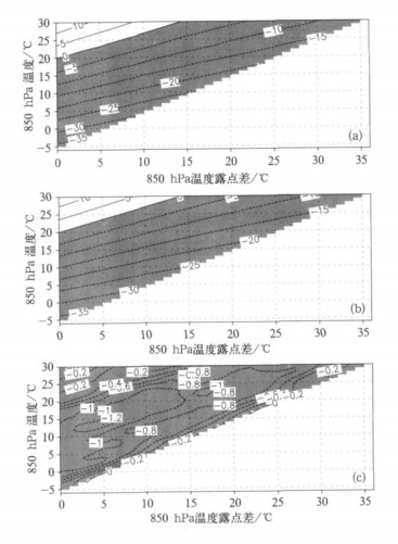
摘要: 为了提高沙瓦特指数的计算精度, 在沙瓦特指数计算方案中引入二分法:先用于计算抬升凝结高度上的要素, 进而计算假相当位温, 再依据假相当位温守恒性质用于计算500 hPa气块温度。与其他方案对比表明, 该迭代算法计算的沙瓦特指数精度较高; 与查表法所得的气块温度对比表明, 该迭代算法得到的气块温度的最大绝对误差为1.36 ℃, 平均误差 (-0.68 ℃) 与平均绝对误差 (0.69 ℃) 数值接近; 迭代算法与查表法之间以系统性偏差为主; 此外, 该迭代算法计算量小, 收敛速度快, 具有推广应用价值。Abstract: In order to improve computational accuracy of Showalter Index, a bisection iterative method (BIM) is introduced to the calculating scheme in two parts: One part is the computation of atmospheric properties of lifted condensation level (LCL), which are requisite to potential pseudo-equivalent temperature (PET) calculation. The other is computation of 500 hPa temperature of the parcel lifted pseudo-adiabatically from LCL keeping PET conservation. Comparing BIM with schemes of Zhang shows that Showalter Index computed by BIM reaches an acceptable accuracy level. Furthermore, the BIM is evaluated by contrasting it to table interpolating method (TIM) of Shou through their 500 hPa parcel temperature difference analysis. Result shows that BIM temperatures are less than those of TIM uniformly with the maximal absolute error of 1.36 ℃. Statistically, the average (-0.68 ℃) and average absolute errors (0.69 ℃) are quite close in magnitude, which shows that the differences are systematic ones. The possible cause is that to the BIM, pseudo-adiabatic parcel ascent is considered, in which all condensed water is instantly removed from the parcel. While the 500 hPa parcel temperature of TIM might be obtained by adiabatic process with entrainment of all condensed water, which can be regarded as the inner heat source of the parcel system consisting of saturated air parcel and condensed water of the adiabatic ascent. The physics difference means that the nearer to saturate the air parcel at initial position of 850 hPa is, the larger negative difference in magnitude between BIM and TIM parcel temperature on 500 hPa there is. In the lower section between -5 and 10 ℃ of 850 hPa air parcel temperature, the 500 hPa parcel temperature difference distribution is consistent with the above mechanism. While in the left interval from 11 to 30 ℃ upper section, the magnitude of 500 hPa temperature difference decreases following an increasing process with 850 hPa dew point depression increasing, which can be only partly interpreted through the mechanism. Computational algorithm and adopted experiential formula difference might be the other cause of 500 hPa parcel temperature difference distribution. The BIM is introduced to compute the parcel temperature at given pressure level lifted adiabatically from initial level with known atmospheric properties, which is essential for stability analysis through parcel method. As a result BIM can also be used in the computation of many stability indexes such as modified Showalter Index, lift index, CAPE (convective available potential energy) and CIN (convective inhibition energy). The great computational efficiency and application convenience makes BIM useful for weather diagnostics.
-
表 1 多站点计算的沙瓦特指数及其与查表或点绘求得的沙瓦特指数对比 (单位:℃)
Table 1 Comparison between Showalter indexes computed by bisection method and those by table/chart interpolating at multi-stations (unit:℃)

表 2 以查表法为参照二分法及其均值订正后计算的500 hPa气块温度的统计对比 (单位:℃)
Table 2 Statistical error features of 500 hPa parcel temperatures computed by bisection and its mean value correction referring to those of table interpolating (unit:℃)

-
[1] Showalter A K. A stability index for thunderstorm forecasting. Bull Amer Meteoro Soc, 1953, 34:250-252. [2] Schaefer J T.Severe thunderstorm forecasting: A historical perspective.Wea Forecasting, 1986, 1:164-189. doi: 10.1175/1520-0434(1986)001<0164:STFAHP>2.0.CO;2 [3] 刘健文, 郭虎, 李耀东, 等.天气分析预报物理量计算基础.北京:气象出版社, 2005:77-86. [4] Curtis R C, Panofsky H A.The relation between large-scale vertical motion and weather in summer.Bull Amer Meteor Soc, 1958, 39:521-531. [5] Hovanec R D, Horn L H.Static stability and the 300 mb isotach field in the Colorado cyclogenesis area.Mon Wea Rev, 1975, 103:628-638. doi: 10.1175/1520-0493(1975)103<0628:SSATMI>2.0.CO;2 [6] Huntrieser H, Schiesser H H, Schmid W, et al.Comparison of traditional and newly developed thunderstorm indices for Switzerland.Wea Forecasting, 1997, 12:108-125. doi: 10.1175/1520-0434(1997)012<0108:COTAND>2.0.CO;2 [7] Galway J G.The lifted index as a predictor of latent instability.Bull Amer Meteor Soc, 1956, 37:528-529. http://www.scirp.org/reference/ReferencesPapers.aspx?ReferenceID=396819 [8] Prosser N E, Foster D S.Upper air sounding analysis by use of an electronic computer.J Appl Meteor, 1966, 5:296-300. doi: 10.1175/1520-0450(1966)005<0296:UASABU>2.0.CO;2 [9] Peppier R A, Lamb P J.Tropospheric static stability and central North American growing season rainfall.Mon Wea Rev, 1989, 117:1156-1180. doi: 10.1175/1520-0493(1989)117<1156:TSSACN>2.0.CO;2 [10] Sanders F.Temperatures of air parcels lifted from the surface :Background, application and nomograms.Wea Forecasting, 1986, 1:190-205. doi: 10.1175/1520-0434(1986)001<0190:TOAPLF>2.0.CO;2 [11] Haklander J, Delden A V.Thunderstorm predictors and their forecast skill for the Netherlands.Atmos Res, 2003, 67-68:273-299. doi: 10.1016/S0169-8095(03)00056-5 [12] Gary L A, Peter H H, Paul T S, et al.Atmospheric Sciences Section Illinois State Water Survey Final Report, Illinois Precipitation Enhancement (Phase Ⅰ), Design and Evaluation Techniques for High Plains Cooperative Program, 1977. [13] 寿绍文, 励申申, 王善华, 等.天气学分析.北京:气象出版社, 2002:179. [14] 张年成, 朱俊峰, 陈红萍, 等.沙氏指数计算方案探讨.气象科技, 2007, 35(2):171-174. http://www.cnki.com.cn/Article/CJFDTOTAL-QXKJ200702002.htm [15] 乔全明, 阮旭春.天气分析.北京:气象出版社, 1988:41-75. [16] Emanuel K A.Atmospheric Convection.New York:Oxford University Press, 1994:329-391. [17] Moncrieff M W, Miller M J.The dynamics and simulation of tropical cumulonimbus and squall lines.Quart J Roy Meteor Soc, 1976, 102:373-394. doi: 10.1002/(ISSN)1477-870X [18] Colby F P Jr.Convective inhibition as a predictor of convection during AVE-SESAME Ⅱ. Mon Wea Rev, 1984, 112: 2239-2252. doi: 10.1175/1520-0493(1984)112<2239:CIAAPO>2.0.CO;2 [19] Miller R C.Notes on Analysis and Severe Storm Forecasting Procedures of the Air Force Global Weather Center.Tech Rep 200(Rev).AWS:U S Air Force, 1972. [20] Jacovides C P, Yonetani T.An evaluation of stability indices for thunderstorm prediction in Greater Cyprus.Wea Forecasing, 1990, 5:559-569. doi: 10.1175/1520-0434(1990)005<0559:AEOSIF>2.0.CO;2 -


 设为首页
设为首页 加入收藏
加入收藏


 下载:
下载:
