
 设为首页
设为首页 加入收藏
加入收藏

利用多普勒雷达径向速度提取台风环境风场信息
Extracting Typhoon Environmental Wind Field Using Doppler Radar Radial Velocity
-
摘要: 应用蓝金模式模拟了纯气旋性旋转的多普勒雷达径向速度特征,还模拟了不同环境风向和吹向台风中心的辐合风对台风多普勒速度特征的影响。在此基础上,提出了雷达实测台风速度的特征和不同环境风向的速度数值模拟图进行比较,从而提取出相应环境风信息的方法,并应用这种环境风信息来判断台风的移动路径。通过对台风实例分析,特别是在台风发生转折的关键时刻,该方法都能够较准确地判断环境风转折的多普勒速度特征。应用多普勒雷达径向速度图像与不同环境风向模拟图像进行比较的方法,能够实时(雷达观测时间间隔仅为6 min)监测到环境气流的方向及其变化,比较准确地监测台风的移动路径,这是其他大尺度气象资料难以做到的。分析表明:环境风转向变化的现象在前,台风发生转折的现象在后,对台风路径的短时预报具有一定应用价值。Abstract: It is always a challeging subject to forecast landing path of tropical cyclone and related wind distribution in operational weather forecast. Therefore, Doppler radar radial velocity is applied to the short term weather forecast as a new attempt. Rankine model is used to simulate the characteristics of the Doppler velocity (CDV) in the pure cyclone, and the impacts of both different environmental wind directions and convergent wind towards typhoon center are considered. Based on the simulation, the method of extracting typhoon environmental wind information is brought up, and then the extracted environmental wind is applied to judge the typhoon path. Comparison of radar observation and numerical simulation typhoon wind mainly focuses on three aspects: Deviation of typhoon center from zero velocity line, curvature difference of zero velocity line and difference between orders of positive and negative extreme velocities. A number of typhoon cases have been analyzed, especially during the key time of the turning of typhoon path, and it indicates that this method is good enough to judge the turning of the environmental wind of the CDV. At the same time, by comparing the Doppler radar velocity image and the simulation of different environmental wind directions, the direction and its change of the environmental air flow can be real time monitored (only 6 minutes for the interval of radar observation), so that the typhoon path can be well monitored, while this can hardly be achieved with large scale meteorological data. In particular, the turning of environmental wind occurs before the turning of typhoon path. For instance, the movement path of typhoon Aere changes from westward to southwestward and the simulation shows that there is an obvious change of the environmental wind more than 3 hours ago. For typhoon Nock Ten, when its movement path changes from northward to northwestward, the environmental wind direction changes from southward to southward by eastward at least 1 hour in advance. These results are important for the short term forecast of typhoon path both theoretically and practically. The stronger a typhoon is, the more obvious cyclonical circulation is, and thus the method performs better in estimating typhoon path, otherwise typhoon environmental wind information may affect the accuracy.
-
Key words:
- Doppler velocity;
- typhoon;
- environmental wind;
- turning of typhoon path
-
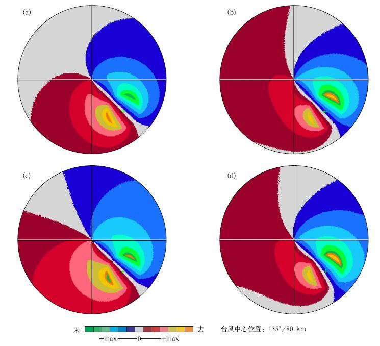
图 1 台风环流多普勒雷达速度图像 (a) 纯台风环流,(b) 存在风向为135°环境风影响,(c) 存在风向为45°环境风影响,(d) 同时考虑辐合风和环境风
Fig. 1 The simulation of Doppler velocity about typhoon circulation (a) with typhoon only, (b) with environmental wind (wind direction: 135°), (c) with environmental wind (wind direction: 45°), (d) with convergence wind and environmental wind simultaneously
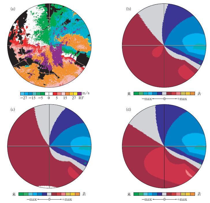
图 2 2004年8月25日03:59艾利台风速度图像 (台风中心位置:115°/127km;大风半径:50km,极大风速:30m/s,环境风速:10m/s) (a) 雷达实测多普勒速度图,(b) 环境风为90°模拟图,(c) 环境风为115°模拟图,(d) 环境风为65°模拟图
Fig. 2 Velocity images of typhoon Aere at 03: 59 25 August 2004 (the typhoon center location: 115°/127 km; the radius of high wind: 50 km, maximum wind velocity: 30 m/s,enviromental wind velocity: 10 m/s) (a) measured by radar, (b) simulated in wind direction of 90°,(c) simulated in wind direction of 115°, (d) simulated in wind direction of 65°
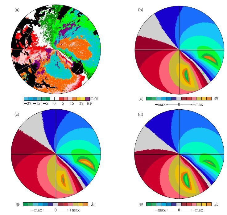
图 3 2004年8月25日05:43艾利台风速度图像 (台风中心位置:135°/100km;大风半径:50km,极大风速:60m/s,环境风速:10m/s)(a) 雷达实测多普勒速度图,(b) 环境风为45°模拟图,(c) 环境风为70°模拟图,(d) 环境风为20°模拟图
Fig. 3 Velocity images of typhoon Aere at 05: 43 25 August 2004 (the typhoon center location: 135°/100 km; the radius of high wind: 50 km, maximum wind velocity: 60 m/s, enviromental wind velocity: 10 m/s)(a) measured by radar,(b) simulated in wind direction of 45°,(c) simulated in wind direction of 70°, (d) simulated m wind direction of 20°

图 4 洛坦台风JTWC预报图 (a) 和实况 (b) 对比
Fig. 4 The comparison of the forecasting of typhoon Nock-Ten by JTWC (a) to observation(b)
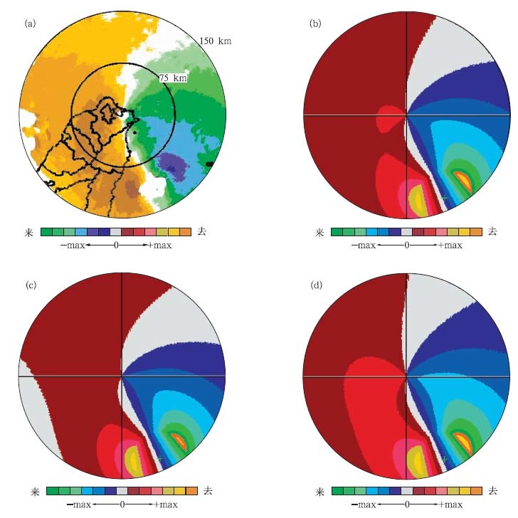
图 5 2004年10月24日23:44洛坦台风速度图像 (台风中心位置:160°/118km;大风半径:35km,极大风速:60m/s,环境风速:10m/s)(a) 雷达实测多普勒速度图,(b) 环境风为160°模拟图,(c) 环境风为185°模拟图,(d) 环境风为135°模拟图
Fig. 5 Velocity images of typhoon Nock-Ten at 23:44 24 October 2004 (the typhoon center location: 160°/118 km; the radius of high wind: 35 km, maximum wind velocity: 60 m/s, enviromental wind velocity: 10 m/s)(a) measured by radar, (b) simulated in wind direction of 160°,(c) simulated in wind direction of 185°, (d) simulated in wind direction of 135°
-
[1] Vickery P J.Simple empirical models for estimating the increase in the central pressure of tropical cyclones after landfall along the coastline of the United States.J Appl Meteor,2005,44:1807-1826. doi: 10.1175/JAM2310.1 [2] Roy Bhowmik S K,Kotal S D,Kalsi S R.An empirical model for predicting the decay of tropical cyclone wind speed after landfall over the Indian region.J Appl Meteor,2005,44: 179-185. doi: 10.1175/JAM-2190.1 [3] Willoughby H E,Rappaport E N,Marks F D.Hurricane Forecasting,the State of the Art.Hurricane Forecast Socioeconomic Working Group,Pomona CA,2005. [4] 陈联寿,罗哲贤,李英.登陆热带气旋研究的进展.气象学报, 2004,62(5):541-549. http://www.cnki.com.cn/Article/CJFDTOTAL-QXXB200405003.htm [5] Lee W C,Jou B J,Chang P L,et al. Tropical cyclone kinematic structure retrieved from single-Doppler radar observations.Part Ⅰ:Interpolation of Doppler velocity patterns and the GBVTD technique.Mon Wea Rev,1999,127(10):2419-2439. doi: 10.1175/1520-0493(1999)127%3C2419%3ATCKSRF%3E2.0.CO%3B2 [6] Lee W C,Marks F D.Tropical cyclone kinematic structure retrieved from single-Doppler radar observations.Part Ⅱ:The GBVTD-simplex center finding algorithm.Mon Wea Rev,2000,128(6):1925-1936. doi: 10.1175/1520-0493(2000)128<1925:TCKSRF>2.0.CO;2 [7] Micheal B M,Lee W C.Improved Tropical Cyclone Circulation Centers Derived from the GBVTD-simpler Algorithm//Preprints,31st Confon Radar Meteor. American Meteor Soc,2003:1012-1014. [8] 魏应植,汤达章,许健民,等.多普勒雷达探测“艾利”台风风场不对称结构.应用气象学报,2007,18(3):285-294. http://qikan.camscma.cn/jams/ch/reader/view_abstract.aspx?file_no=20070350&flag=1 [9] 王峰云,王燕雄,陶祖钰.单多普勒天气雷达的中尺度风场探测技术研究.热带气象学报,2003,19(3):291-298. http://www.cnki.com.cn/Article/CJFDTOTAL-RDQX200303008.htm [10] 顾建峰,薛纪善,颜宏.多普勒雷达四维变分分析系统概述.热带气象学报,2004,20(1):1-13. http://www.cnki.com.cn/Article/CJFDTOTAL-RDQX200401000.htm [11] 魏应植,吴陈锋,林长城,等.冷空气侵入台风“珍珠”的多普勒雷达回波特征.热带气象学报,2008,24(6):599-608. http://www.cnki.com.cn/Article/CJFDTOTAL-RDQX200806004.htm [12] 陈联寿,徐祥德,罗哲贤,等.热带气旋动力学引论.北京:气象出版社,2002:17-146;248-304. [13] 王楠,刘黎平,徐宝祥,等.利用多普勒雷达资料识别低空风切变和辐合线方法研究.应用气象学报,2007,18(3):314-320. http://qikan.camscma.cn/jams/ch/reader/view_abstract.aspx?file_no=20070353&flag=1 [14] 陈德辉,王诗文,汪厚君.改进的物理过程参数化对台风路径数值预报的影响.应用气象学报,1996,7(1):1-8. http://qikan.camscma.cn/jams/ch/reader/view_abstract.aspx?file_no=19960101&flag=1 [15] 麻素红,瞿安祥,张眙.台风路径数值预报模式的并行化及路径预报误差分析.应用气象学报,2004,15(3):322-328. http://qikan.camscma.cn/jams/ch/reader/view_abstract.aspx?file_no=20040341&flag=1 [16] 张守峰,王诗文.应用卫星云导风进行台风路径预报试验.热带气象学报,1999,15(4):347-355. http://www.cnki.com.cn/Article/CJFDTOTAL-RDQX199904007.htm [17] 胡明宝,高太长,汤达章.多普勒天气雷达资料分析与应用.北京:解放军出版社,2000:90-140. -

 下载:
下载:
计量
- 摘要浏览量: 4285
- HTML全文浏览量: 936
- PDF下载量: 2579
- 被引次数: 0
