
 设为首页
设为首页 加入收藏
加入收藏

Ground-based Dual-band Cloud Observing System and Its Comparative Experiments
-
摘要: 针对地基测云系统中云在可见光波段与红外波段中表现出的不同特性,用双站数字式云高仪所测云高进行标校,结合地面实时观测天顶红外辐射亮温及地面环境参数,分析地面到云层底大气对红外辐射亮温的影响,从中发现利用天空红外辐射亮温来遥感云底高度的可行性,研发地基双波段测云系统。该系统以对流层大气的垂直温度递减率为理论基础,建立云层底到地面的温度递减梯度参数K,根据递减梯度参数反演天顶方向的云高。该算法不依赖于探空数据,通过实时定标形式得出符合仪器所在地的云底高反演公式。通过与维萨拉激光云高仪CL31进行数据对比分析得出,地基双波段测云系统反演结果具有较高的准确性。Abstract: Clouds affect the energy balance of the earth by means of absorbing and scattering radiation, and they have influences on global climate. Precipitation of clouds is the most familiar way for the earth water circulation. In the macroscopic parameters of clouds, cloud cover and cloud base height are the primary elements in the observation of clouds, where the cloud base height condition determines cloud classification and precipitation probability. However, artificial visual observation is the main method used in China at present, which are not objective and waste a mass of work force. Therefore, the research and development of an automatic measuring cloud device is extremely necessary.A ground-based cloud observing system consists of an infrared temperature measuring sensor and a double location digital ceilometer. The double location digital ceilometer calculates the cloud height of zenith by geometry method at regular time, and the infrared temperature measuring sensor acquires brightness temperature of atmospheric radiation in real time. Based on the different characteristics of visible and infrared cloud images, the height of clouds is derived and tested by the double location digital ceilometer, combined with real-time observation of zenith single-point infrared brightness temperature and ground environmental parameters. The influence of sub cloud air from ground to clouds bottom on infrared brightness temperature is analyzed, showing the feasibility of cloud base height remote sensing by ground-based sky infrared brightness temperature. The result shows that for low and middle clouds, the sky radiation brightness temperature of ground-based observation is relatively sensitive to the variation of cloud base height, therefore it can be used to estimate cloud base height. On the basis of decreasing principle of tropospheric vertical temperature, the temperature decreasing gradient parameter K from cloud base to the ground is defined and according to the decreasing gradient parameter inverse the cloud height of zenith direction. The algorithm does not depend on the air sounding data, and the formula of cloud base height is derived in practice. Double location digital ceilometer can measure a cloud height only when the bottom of the cloud has texture, and then K can be calculated, therefore the double location digital ceilometer is a calibration device in the ground-based measuring cloud system.Experimental observation has been performed using dual-band cloud observation system in the synthesize experiment base of CMA Meteorological Observation Center since July 2010, and cloud height data of the zenith is acquired each minute. Through the comparative data analysis with Vaisala CL31, ground-based dual-band cloud observation systems can provide results with high accuracy.
-

图 2 天顶红外辐射亮温随时间变化
Fig. 2 Zenith point infrared brightness temperature change with time
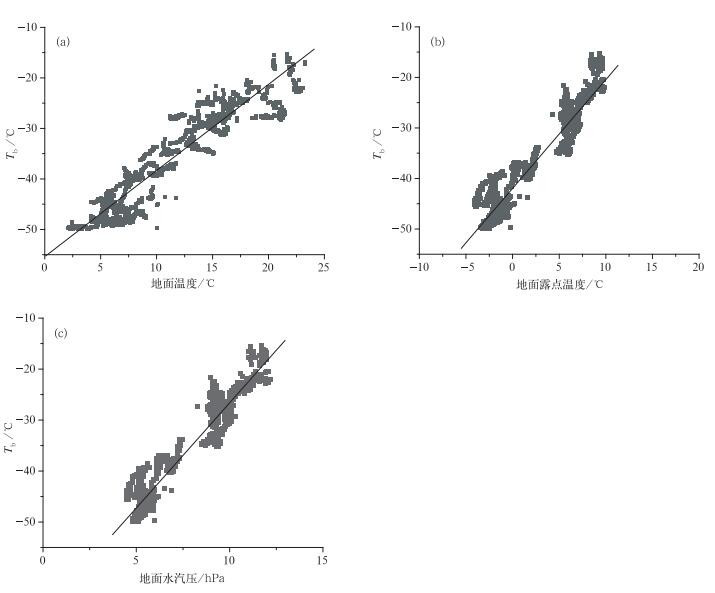
图 3 晴空条件下地面环境因子与天顶亮温的关系
Fig. 3 Relations between Tb in zenith direction and surface environmental parameters in clear sky condition
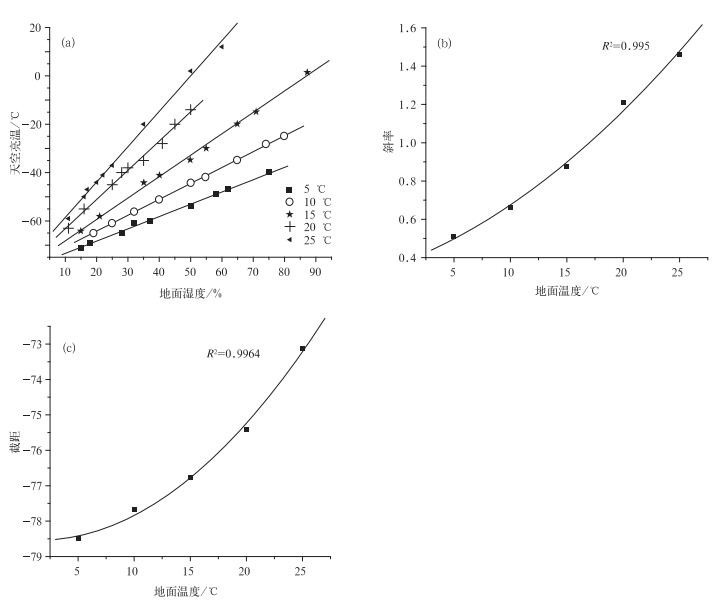
图 4 不同地面温度条件下地面湿度与天顶亮温之间的关系 (a) 及地面温度与各拟合系数斜率 (b) 和截距 (c) 之间的关系
Fig. 4 Relations between Tb in zenith direction and surface humidity in different surface temperature (a), relations between surface temperature and fitting coefficient slope (b) with intercept (c)
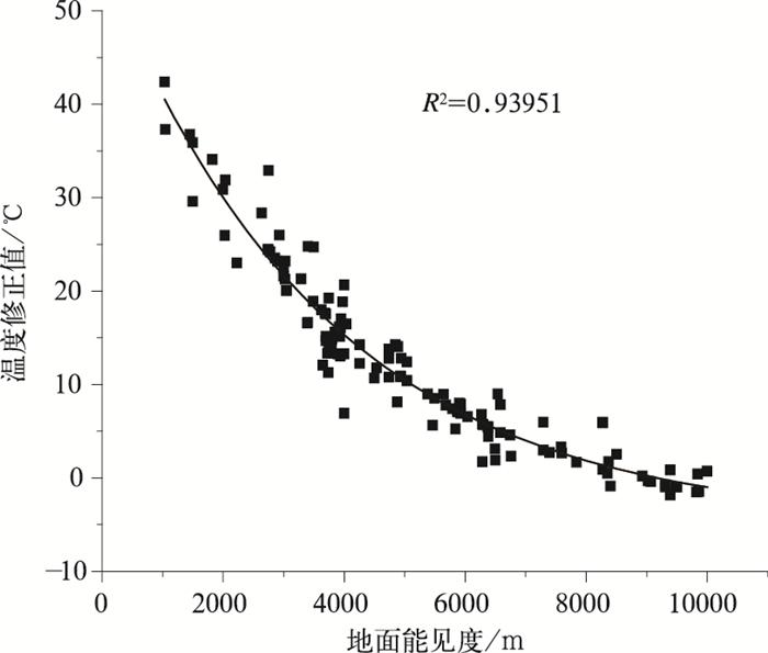
图 5 地面能见度与修正温度之间的关系
Fig. 5 Relations between the range of surface visibility and modified temperature

图 6 2011年3月北京市观象台探空气球所测大气温度与海拔高度廓线
Fig. 6 Balloons measured temperature and altitude profile of Beijing Weather Observatory in Mar 2011
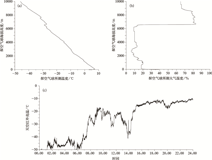
图 7 2011年3月19日07:00北京市观象台探空气球所测大气温度 (a)、湿度 (b) 与海拔高度廓线和全天地面天顶红外辐射亮温曲线 (c)
Fig. 7 Balloons measured temperature and altitude profile (a), humidity and altitude profile (b) on 0700 BT 19 Mar 2011 and time series of Beijing Weather Observatory zenith point infrared brightness temperature (c)
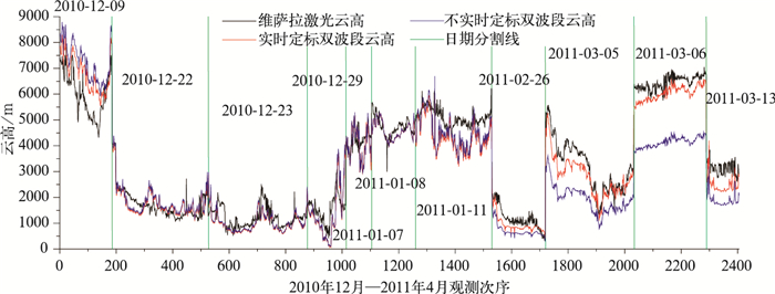
图 9 由Tb反演计算的云高与CL31观测云高对比
Fig. 9 Comparison of cloud base height derived from Tb and observed by CL31
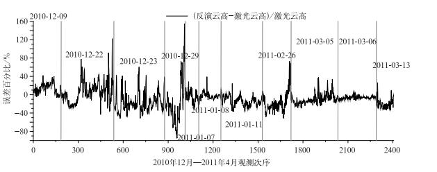
图 10 红外反演云高与激光所测云高相对误差百分比
Fig. 10 The percentage relative error of cloud base height derived from Tb and observed by CL31

图 11 2010年12月—2011年4月云高对应散点图
Fig. 11 Scattered plot of cloud base height from December 2010 to April 2011
表 1 无云时刻地面温度恒定不同湿度条件下推算出的天空亮温
Table 1 The sky infrared brightness temperature calculated in clear sky conditions with constant ground temperature and different humidity
5℃ 10℃ 15℃ 20℃ 25℃ 湿度/% 亮温/℃ 湿度/% 亮温/℃ 湿度/% 亮温/℃ 湿度/% 亮温/℃ 湿度/% 亮温/℃ 75 -40 80 -25 87 2 50 -14 60 12 62 -47 74 -28 71 -15 45 -20 50 2 58 -49 65 -35 65 -20 41 -28 35 -20 50 -54 55 -42 55 -30 35 -35 25 -37 37 -60 50 -44 50 -35 30 -38 22 -41 32 -61 40 -51 40 -41 28 -40 20 -44 28 -65 32 -56 35 -44 25 -45 17 -47 18 -69 25 -61 21 -58 16 -55 16 -50 15 -71 19 -65 15 -64 11 -63 11 -59  下载: 导出CSV
-
[1] 刘健, 张里阳.气象卫星高空间分辨率数据的云量计算与检验.应用气象学报, 2011, 22(1):35-45. doi: 10.11898/1001-7313.20110104 [2] 高太长, 刘磊, 赵世军.等.全天空测云技术现状及进展.应用气象学报, 2010, 21(1):101-109. doi: 10.11898/1001-7313.20100114 [3] Shields J E, Karr M E, Tooman T P, et al. The Whole Sky imager-A Year of Progress. Eighth Atmospheric Radiation Measurement Science Team Meeting, 1998. [4] Long C N, Slater D W, Tooman T. Total Sky Imager Model 880 Status and Testing Results. ARM Technical Report ARM TR-006, US Department of Energy, Washington DC, 2001. [5] 王青梅, 张以谟, 刘铁根, 等.一种便携式激光测云仪的云底高度反演算法.强激光与粒子束, 2005, 17(9):1312-1316. http://www.cnki.com.cn/Article/CJFDTOTAL-QJGY200509007.htm [6] Genkova I, Long C N, Besnard T, et al. Assessing Cloud Spatial and Vertical Distribution with Infrared Cloud Analyzer. Fourteenth ARM Science Team Meeting Proceedings, Albuquerque, New Mex, co, Mar 22-26, 2004. [7] 霍娟, 吕达仁.全天空数字相机观测云量的初步研究.南京气象学院学报, 2002, 25(2):242-246. http://www.cnki.com.cn/Article/CJFDTOTAL-NJQX200202014.htm [8] 章文星, 吕达仁, 常有礼.地基热红外亮温遥感云底高度可行性的模拟研究.地球物理学报, 2007, 50(2):354-363. http://www.cnki.com.cn/Article/CJFDTOTAL-DQWX200702003.htm [9] 郄秀书, 吕达仁, 陈洪滨, 等.大气探测高技术及应用研究进展.大气科学, 2008, 32(4):867-881. http://www.cnki.com.cn/Article/CJFDTOTAL-DQXK200804013.htm [10] 孙学金.云的地基全天空红外遥感研究.北京:北京大学物理学院大气科学系, 2009. [11] 孙学金, 刘磊, 高太长, 等.基于模糊纹理光谱的全天空红外图像云分类.应用气象学报, 2009, 20(2):157-163. doi: 10.11898/1001-7313.20090204 [12] 谭涌波, 陶善昌, 吕伟涛, 等.双站数字摄像测量云高.应用气象学报, 2005, 16(5):629-637. doi: 10.11898/1001-7313.20050509 [13] Liou K N. 大气辐射导论. 郭彩丽, 周诗健, 译. 北京: 气象出版社, 2004: 122-127. [14] 盛裴轩, 毛节泰, 李建国.大气物理学.北京:北京大学出版社, 2003:11-15;48-49. [15] 张玲, 张小平, 葛凡.借用探空数据校对云高的分析.科技资讯, 2009, 1:42-44. doi: 10.3969/j.issn.1672-3791.2009.01.033 -


计量
- 摘要浏览量: 3314
- HTML全文浏览量: 1071
- PDF下载量: 1454
- 被引次数: 0
