The Development of Urban Climatic Map and Its Current Application Situation
-
摘要: 城市环境气候图最初于20世纪70年代由德国气候研究者开发制作,通过近40年的发展,目前在世界范围内已有20个国家开展了相关研究与应用项目,从而为改善城市气候环境与提高人居生活条件提供决策依据。该文首先对城市环境气候图的发展及其制作方法进行了一个总体性的回顾,然后选取德国、日本和中国香港地区的研究案例用以考察目前该领域研究和应用现状与存在问题,进一步详细探讨了未来发展的方向,最后指出了在我国城市化进程中为应对诸多气候环境问题所迫切需要开展的相关研究问题。Abstract: More than half of the world population now lives in urban areas. According to UN report in 2008, by 2030, nearly 60% of the humanity will be urban dwellers. The rapid urbanization in the past half a century has not only brought new immigrants into the urban areas, but also has gradually changed the physical urban environment. There has been a worldwide vision to design cities which are sustainable, healthy, comfortable, and even enjoyable. Thus, it is necessary to bridge the gap between urban climatology and town planning and urban design, and to transfer the climatic knowledge into planning languages. Facing the global issue of climate change, it is also necessary to include the changing climatic considerations holistically and strategically in the planning process, and to update city plans. Recently urban climatology and its application studies have gained world-wide public concern from a series of international conferences and published official reports, e.g., the white paper on "Climate and More Sustainable Cities" published by World Climate Conference-3, United Nations Conference on Climate Change in Copenhagen in 2009, training workshop on urban climate by World Meteorological Organization, Climate Change and Cities-First Assessment Report of the Urban Climate Change Research Network in 2011, etc. Among them, the study of urban climatic map (UCMap) has been popular. It is first developed by German in the 1970s. Now over 40 years development, there are about 20 countries having their own UCMap studies and relevant application projects for improving urban climatic condition and providing information reference for the design of human living environment.Facing the global issue of climate change, it is also necessary to include the changing climatic considerations holistically and strategically in the planning process, and to update city plans. The historical development of UCMap study is reviewed, introducing the key concepts, methodologies, framework and procedures of developing UCMap. The current application situation in Germany, Japan and Hong Kong of China are selected to conduct case studies for exploring their advantages and existing problems. The key lessons of each case study are also provided. Furthermore, according the current situation of China, the urgent need to carry out such study is also pointed out to deal with the environmental problems caused by the recent fast urbanization and solve the conflict among social need, economic benefits, landscape and ecological environment. Due to the poor quality of meteorological data and the urgency of application, a simplified method is expected to apply for development of middle-mage cities and new rural construction of China. Also, the future trend of UCMap study is discussed, which should develop a quantitive method of defining and validating climatope, make the feasibility of application into urban planning, and adopt the climate change into consideration.
-
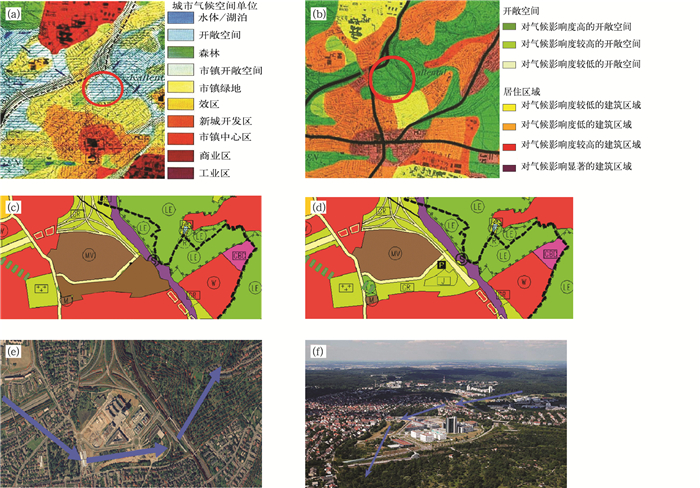
图 3 德国斯图加特城市气候图的成功应用案例[3]
(a) 城市气候分析图局部, (b) 城市气候规划建议图局部, (c) 原定土地使用规划图, (d) 修改后的土地使用规划图, (e) 冷空气输送廊道, (f) 受惠区域
Fig. 3 Successful implementation example of Stuttgart UCMap study in Germany[3]
(a) UC-AnMap of Stuttgart, (b) UC-ReMap of Stuttgart, (c) original land use plan, (d) revised land use plan, (e) air path, (f) ventilation zone
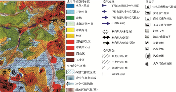
表 1 城市环境气候图制作的考虑要素
Table 1 Climatic analysis and phenomena in the development of an UCMap
要素 主要内容 气候要素 海拔高度, 地形地势,
地表结构, 绿化, 地表水体土地利用要素 水体、湖泊, 开放空间 (空地),森林,
市内绿地公园,郊区,市区中心,
工业用地, 商业用地, 新鲜冷空气廊道空气污染要素 空气污染源, 空气污染的扩散分布 -
[1] Leung Y K, Yip K M, Yeung K H. Relationship between thermal index and mortality in Hong Kong. Meteorol Appl, 2008, 15: 399-409. doi: 10.1002/met.v15:3 [2] Cleugh H, Emmanuel R, Endlicher W, et al. Climate and Sustainable Cities: Climate Information for Improved Planning and Management of Mega Cities (Needs and Capabilities Perspectives), Geneva: WMO, 2009. [3] Baumüller J, Hoffmann U, Reuter U. Climate booklet for urban development, Stuttgart: Environmental Protection Department of Ministry of Economy Baden-Wuerttemberg, 1992. [4] VDI-Guideline 3787-Part 1: Environmental Meteorology-Climate and Air Pollution Maps for Cities and Regions. Berlin: Beuth Verlag, 1997. [5] Scherer D, Fehrenbach U, Beha H D, et al. Improved concepts and methods in analysis and evaluation of the urban climate for optimizing urban planning process. Atmos Environ, 1999, 33: 4185-4193. doi: 10.1016/S1352-2310(99)00161-2 [6] Matzarakis A. Country Report: Urban climate research in Germany. IAUC Newsletter, 2005, 11: 4-6. http://www.urbanclimate.net/matzarakis/papers/UCRE_de_IAUC011.pdf [7] Ren C, Ng E, Katzschner L. Urban climatic map studies: A review. International Journal of Climatology, 2011, 31(15): 2213-2233. doi: 10.1002/joc.v31.15 [8] Knoch K. Uber das Wesen einer Landesklimaaufnahme. Z Meteorol, 1951, 5: 173. [9] Lüttig G W. Geoscientific maps of the environment as an essential tool in planning. Geol en Mijnb, 1978, 57 (4): 527-532. [10] Baumüller J, Reuter U. Demands and Requirements on a Climate Atlas for Urban Planning and Design, Stuttgart: Office of Environmental Protection, 1999. [11] Baumüller J, Flassak T, Schädler G, et al. "Urban climate 21"—Climatological Basics and Design Features for "Stuttgart 21". Report of Research Center for Urban Safety and Security Kobe University, 1998: 42-52. http://ci.nii.ac.jp/naid/110000074759/en [12] Scherer D, Fehrenbach U, Beha H-D, et al. Improved concepts and methods in analysis and evaluation of the urban climate for optimizing urban planning process. Atmos Environ, 1999, 33: 4185-4193. doi: 10.1016/S1352-2310(99)00161-2 [13] KVR. Kommunal Verband Ruhrgebiet: Synthetische Klimafunktionskarte. Essen: Ruhrgebiet, 1980. [14] Sterten A K. A thematic mapping system and a description of local climatic conditions developed for urban planning purposes. Energy and Buildings, 1982, 4: 121-124. doi: 10.1016/0378-7788(82)90036-6 [15] Lindqvist S, Mattsson J. Topoclimatic maps for different planning levels-some Swedish examples. Building Research and Practice, 1989, 5: 299-304. https://www.researchgate.net/publication/262013380_Topoclimatic_maps_for_different_planning_levels_Some_Swedish_examples?ev=prf_cit [16] Paszynski J. Mapping urban topoclimates. Energy and Buildings, 1991, 16 (3-4): 1059-1062. doi: 10.1016/0378-7788(91)90099-O [17] Unger J. Intra-urban relationship between surface geometry and urban heat island: Review and new approach. Climate Research, 2004, 27: 253-264. doi: 10.3354/cr027253 [18] Hsie T S. A GEO-based modelling and management tool for determing urban morphology and natural ventilation potentials. Environmental Engineering and Management Journal, 2006, 5(6): 1301-1311. https://www.cabdirect.org/?target=%2fcabdirect%2fabstract%2f20103106402 [19] Gal T, Unger J. Detection of ventilation paths using high-resolution roughness parameter mapping in a large urban area. Building and Environment, 2009, 44: 198-206. doi: 10.1016/j.buildenv.2008.02.008 [20] Evans J M, de Schiller S. Climate and urban planning: The example of the planning code for Vicente Lopez, Buenos Aires. Energy and Buildings, 1990/1991, 15: 35-41. doi: 10.1016/0378-7788(90)90113-W [21] Ashie Y, Kodama Y, Asaeda T, et al. Climate Analysis for Urban Planning in Tokyo. Departmental Bulletin Paper, Kobe: Kobe University, 1998. http://ci.nii.ac.jp/naid/110000074763/ [22] Jittawikul A, Saito I, Shihara O. Climatic maps for passive cooling methods utilization in Thailand. Journal of Asian Architecture and Building Engineering, 2004, 3(1): 109-114. doi: 10.3130/jaabe.3.109 [23] Kim H O. Beitrag sehr hochauflösender Satellitenfernerkundungsdaten zur Aktualisierung der Biotop-und Nutzungstypenkartierung in Stadtgebieten-Dargestellt am Beispiel von Seoul. Berlin: der Technischen Universität Berlin, 2007. https://depositonce.tu-berlin.de/handle/11303/1985 [24] Moriyama M, Takebayashi H. Making method of "Klimatope" map based on normalized vegetation index and one-dimensional heat budget model. Journal of Wind Engineering and Industrial Aerodynamics, 1999, 81: 211-220. doi: 10.1016/S0167-6105(99)00018-5 [25] Ichinose T, Shimodozono K, Hanaki K. Impact of anthropogenic heat on urban climate in Tokyo. Atmospheric Environment, 1999, 33: 3897-3909. doi: 10.1016/S1352-2310(99)00132-6 [26] TMG. Guidelines for Heat Island Control Measures [Summary Edition]: Measures to address Heat Island. Tokyo: Bureau of the Environment of Tokyo Metropolitan Government, 2005. [27] Yamamoto Y. Measures to mitigate urban heat islands. Global C-hange and Sustainable Development, 2008, 1(2): 18-46. https://www.mendeley.com/research-papers/measures-mitigate-urban-heat-islands/ [28] AIJ. Observational Studies of the Urban Heat Island-Cooling Effect of Urban Park. Tokyo: Architect Institute of Japan, 2008. [29] AIJ. Urban Environmental Climatic Atlas: Urban Development Utilizing Climate Information. Tokyo: Architectural Institute of Japan, 2000. [30] Groβ G. Numerical Simulation of Canopy Flows. Berlin: Springer, 1993. [31] Vogt J. Bericht über orientierende Untersuchungen zur lokalklimatischen Funktion der Flächen des Gleisdreieckes in Berlin, Voruntersuchung im Auftrag der Vivico Management GmbH, Berlin: Unveröffentlicht, 2002. [32] Federal German Building Code, Berlin: Federal Ministry of Transport, Building and Housing of Germany, 2004. [33] TMG. The Thermal Environment Map and Areas Designated for the Implementation of Measures Against the Heat Island Phenomenon, Tokyo: Bureau of Environment and Bureau of Urban Development of Tokyo Metropolitan Government, 2005. [34] AIJ. National Research Project on Kaze-no-michi: Making the Best Use of the Cool Sea Breeze. Tokyo: Architects Institute of Japan, 2008. [35] Ng E. Towards planning and practical understanding of the need for meteorological and climatic information in the design of high-density cities: A case-based study of Hong Kong. International Journal of Climatology, 2012, 32(4): 582-598. doi: 10.1002/joc.v32.4 [36] HöP. The physiological equivalent temperature-a universal index for the biometeorological assessment of the thermal environment.International Journal of Biometeorology, 1999, 43: 71-75. doi: 10.1007/s004840050118 -


 设为首页
设为首页 加入收藏
加入收藏


 下载:
下载:
