Characteristics of Raindrop Size Distribution for a Squall Line at Chuzhou of Anhui During Summer
-
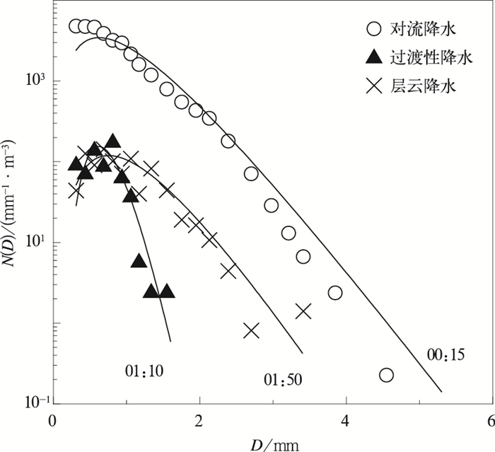
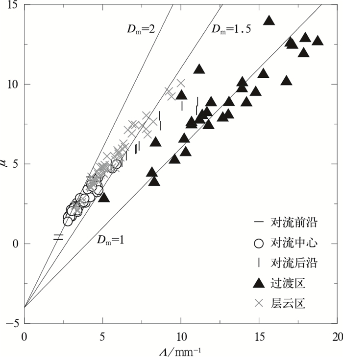
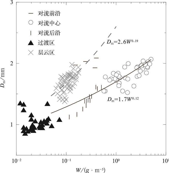
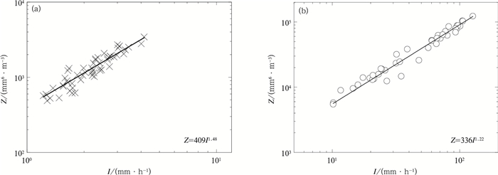
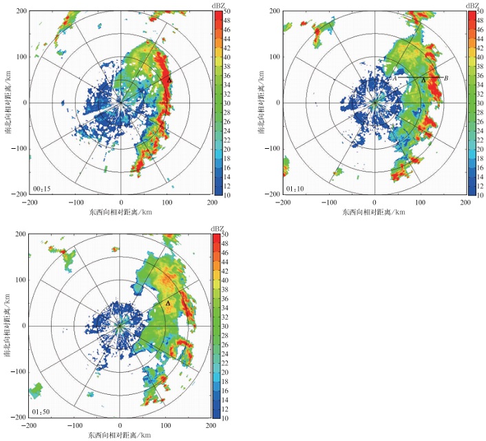
摘要: 选取2014年7月31日安徽滁州一次飑线过程,使用地基雨滴谱仪资料分析此次过程的雨滴谱特征。根据雷达回波和地面降水强度将这次降水过程划分为对流降水、过渡性降水和层云降水,并以10 mm·h-1为临界值将对流降水进一步划分为对流前沿降水、对流中心降水、对流后沿降水。结果表明:对流中心降水、过渡性降水、层云降水的质量加权直径均比较稳定,平均值分别为1.8 mm, 1.0 mm, 1.7 mm。对流降水的标准化截距相比层云降水更大。对流中心降水各粒径段雨滴数浓度均较高;层云降水小雨滴浓度较低,且有少量大雨滴;过渡性降水由小雨滴组成。当雨水含量相同时,层云降水的质量加权直径相比对流降水更大。当雨强相同时,层云降水的反射率因子相比对流中心降水更大。更为精细的降水类型划分可有效改善Z-I关系。Abstract: Characteristics of raindrop size distribution are analyzed using a ground-based disdrometer for a mid-latitude squall line at Chuzhou of Anhui on 31 Jul 2014. The observational precipitation are classified into convective rain, transition rain and stratiform rain based on the radar reflectivity and rain rate at surface. The convective rain is divided into leading edge, convective center and trailing edge according to a threshold rain rate 10 mm·h-1. The raindrop spectrum characteristics in different precipitation regions are studied. Results show that the mass-weighted diameter for convective center, transition region, stratiform region are stable with mean values of 1.8 mm, 1.0 mm and 1.7 mm, respectively. The generalized intercepting parameter Nw of convective precipitation is larger compared with stratiform precipitation, indicating a larger number concentration of drops. The μ value is the largest for transition precipitation but the smallest for convective precipitation. The raindrop spectrums are different for varied rain type. For convective precipitation, it shows a highest concentration of raindrop within each size range, especially for small size of raindrops, which results in a smaller raindrop size than tropic region. For stratiform precipitation consists of a lower number concentration of small drops and less large raindrops, therefore, the spectrum curve is flat. For transition precipitation, the number concentration of small drops is close to stratiform precipitation without large drops, results in a steep spectrum. The mass-weighted diameter for leading edge is large probably caused by gravity separation at the early stage of precipitation. The rainwater content of stratiform precipitation is smaller compared with convective precipitation. The mass-weighted diameter of stratiform precipitation is larger compared with convective precipitation, and it increases more rapidly compared with convective precipitation as the rain water content increasing. The reflectivity is larger for stratiform precipitation compared with convective center precipitation at the same rain rate. The Z-I relationship of stratiform precipitation is Z=409I1.48 when partitioning the rain into convective rain, transition rain and stratiform rain, but Z=395I1.51 when the partitioning is blurred. The Z-I relationship is improved and the accuracy of radar rainfall estimates is enhanced by dividing the rain type more exactly. In summary, although the raindrop size distribution for a squall line at ground is discussed, the knowledge on microphysical process of mid-latitude squall line is still insufficient. Dual polarization radar can be applied to further investigate the microphysical process in different types of internal cloud precipitation in the future.
-
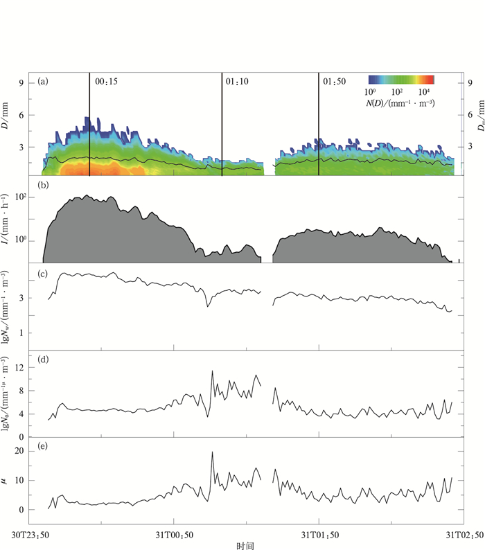
图 3 2014年7月30日23:30—31日02:50谱分布及各微物理参数随时间的变化 (a) 谱分布 (彩色代表数浓度,黑色实线代表Dm),(b) 雨强,(c) lgNw,(d) lgN0,(e)μ
Fig. 3 Time change of raindrop distribution and microphysical parameters from 2330 BT 30 Jul to 0250 BT 31 Jul in 2014 (a) spectral distribution (the shaded denotes number concentration, the black solid line denotes Dm), (b)R, (c) lgNw, (d) lgN0, (e)μ
表 1 2014年7月30日23:58—31日02:27各参数平均值和标准差
Table 1 Mean values and standard deviations of parameters from 2358 BT 30 Jul to 0227 BT 31 Jul in 2014
参数 对流前沿降水 (4个样本) 对流中心降水 (42个样本) 对流后沿降水 (13个样本) 过渡性降水 (33个样本) 层云降水 (54个样本) 平均值 标准差 平均值 标准差 平均值 标准差 平均值 标准差 平均值 标准差 I/(mm·h-1) 6.8 54.0 5.0 0.4 2.3 Nt/m-3 351 103 2524 1294 411 75 92 44 104 22 W/(g·m3) 0.29 0.12 2.40 1.37 0.29 0.11 0.03 0.01 0.11 0.03 Dm/mm 2.0 0.07 1.8 0.15 1.4 0.16 1.0 0.13 1.7 0.14 lgNw/(mm-1·m-3) 3.1 0.19 4.2 0.21 3.8 0.06 3.3 0.27 3.0 0.13 lgN0/(mm-1-μ·m-3) 3.5 0.50 4.7 0.31 5.9 0.88 7.5 1.72 4.4 0.72 μ 1.7 1.78 2.6 0.86 6.4 1.66 9.2 3.43 5.2 1.84 Λ/mm-1 2.9 0.98 3.6 0.77 7.7 2.07 13.2 3.87 5.6 1.58 注:Nt为雨滴总数浓度。 -
[1] Bringi V N, Chandrasekar V, Hubbert J, et al.Raindrop size distribution in different climatic regimes from disdrometer and dual-polarized radar analysis.J Atmos Sci, 2003, 60(2):354-365. doi: 10.1175/1520-0469(2003)060<0354:RSDIDC>2.0.CO;2 [2] Shusse Y, Nakagawa K, Takahashi N, et al.Characteristics of polarimetric radar variables in three types of rainfalls in a baiu front event over the East China Sea.J Meteor Soc Japan, 2009, 87(5):865-875. doi: 10.2151/jmsj.87.865 [3] Oue M, Uyeda H, Lee D I.Raindrop size distribution parameters estimated from polarimetric radar variables in convective cells around Okinawa Island during the baiu period.Asia-Pacific Journal of Atmospheric Sciences, 2011, 47(1):33-44. doi: 10.1007/s13143-011-1003-x [4] 严采蘩, 陈万奎.对流层下部雨滴谱分布.应用气象学报, 1990, 1(2):191-198. http://qikan.camscma.cn/jams/ch/reader/view_abstract.aspx?file_no=19900227&flag=1 [5] 周毓荃, 刘晓天, 周非非, 等.河南干旱年地面雨滴谱特征.应用气象学报, 2001, 12(增刊Ⅰ):39-47. http://www.cnki.com.cn/Article/CJFDTOTAL-YYQX2001S1005.htm [6] Tokay A, Short D A.Evidence from tropical raindrop spectra of the origin of rain from stratiform versus convective clouds.J Appl Meteor, 1996, 35(3):355-371. doi: 10.1175/1520-0450(1996)035<0355:EFTRSO>2.0.CO;2 [7] Atlas D, Ulbrich C W, Marks F D, et al.Systematic variation of drop size and radar-rainfall relations.J Geophys Res, 1999, 104:6155-6169. doi: 10.1029/1998JD200098 [8] Chen B J, Yang J, Pu J.Statistical characteristics of raindrop size distribution in the Meiyu season observed in Eastern China.J Meteor Soc Japan, 2013, 91(2):215-227. doi: 10.2151/jmsj.2013-208 [9] Ulbrich C W, Atlas D.Microphysics of raindrop size spectra:Tropical continental and maritime storms.J Appl Meteor Climatol, 2007, 46(11):777-791. [10] Houze R A.Observed structure of mesoscale convective systems and implications for large-scale heating.Quart J Roy Meteor Soc, 1989, 115:425-461. doi: 10.1002/(ISSN)1477-870X [11] 漆梁波, 陈永林.一次长江三角洲飑线的综合分析.应用气象学报, 2004, 15(2):162-173. http://qikan.camscma.cn/jams/ch/reader/view_abstract.aspx?file_no=20040221&flag=1 [12] 姚建群, 戴建华, 姚祖庆.一次强飑线的成因及维持和加强机制分析.应用气象学报, 2005, 16(6):746-753. doi: 10.11898/1001-7313.20050615 [13] 谢健标, 林良勋, 颜文胜, 等.广东2005年"3·22"强飑线天气过程分析.应用气象学报, 2007, 18(3):321-329. http://qikan.camscma.cn/jams/ch/reader/view_abstract.aspx?file_no=20070354&flag=1 [14] 慕熙昱, 党人庆, 陈秋萍, 等.一次飑线过程的雷达回波分析与数值模拟.应用气象学报, 2007, 18(1):42-49. doi: 10.11898/1001-7313.20070108 [15] Battaglia A, Rustemeier E, Tokay A, et al.PARSIVEL snow observations: A critical assess-ment.J Atmos Ocean Technol, 2010, 27(2):333-344. doi: 10.1175/2009JTECHA1332.1 [16] Tokay A, Bashor P G.An experimental study of small-scale variability of raindrop size distribution.J Appl Meteorol Climatol, 2010, 49(11):2348-2365. doi: 10.1175/2010JAMC2269.1 [17] Ulbrich C W.Natural variations in the analytical form of the raindrop size distribution.J Climate Appl Meteor, 1983, 22(10):1764-1775. doi: 10.1175/1520-0450(1983)022<1764:NVITAF>2.0.CO;2 [18] Testud J, Oury S, Black R A, et al.The concept of "normalized" distribution to describe raindrop spectra:A tool for cloud physics and cloud remote sensing.J Appl Meteor, 2001, 40(6):1118-1140. doi: 10.1175/1520-0450(2001)040<1118:TCONDT>2.0.CO;2 [19] Maki M, Keenan T D, Sasaki Y, et al.Characteristics of the raindrop size distribution in tropical continental squall lines observed in Darwin, Australia.J Appl Meteor, 2001, 40(8):1393-1412. doi: 10.1175/1520-0450(2001)040<1393:COTRSD>2.0.CO;2 [20] Waldvogel A.The N0 jump of raindrop spectra.J Atmos Sci, 1974, 31:1067-1078. doi: 10.1175/1520-0469(1974)031<1067:TJORS>2.0.CO;2 [21] Rosenfeld D.Suppression of rain and snow by urban and industrial air pollution.Science, 2000, 287:1793-1796. doi: 10.1126/science.287.5459.1793 [22] 戴进, 余兴, Rosenfeld D, 等.秦岭地区气溶胶对地形云降水的抑制作用.大气科学, 2008, 32(6):1319-1332. http://www.cnki.com.cn/Article/CJFDTOTAL-DQXK200806007.htm [23] Zhang G, Vivekanandan J, Brandes E A, et al.The shape-slope relation in observed gamma raindrop size distributions:Statistical error or useful information? J Atmos Ocean Technol, 2003, 20(8):1106-1120. doi: 10.1175/1520-0426(2003)020<1106:TSRIOG>2.0.CO;2 [24] Braun S A, Houze R A.The transition zone and secondary maximum of radar reflectivity behind a midlatitude squall line:Results retrieved from Doppler radar data.J Atmos Sci, 1994, 51:2733-2755. doi: 10.1175/1520-0469(1994)051<2733:TTZASM>2.0.CO;2 [25] Rosenfeld D, Ulbrich C W.Cloud microphysical properties, processes, and rainfall estimation opportunities.Meteorol Monogr, 2003, 30:237-258. doi: 10.1175/0065-9401(2003)030<0237:CMPPAR>2.0.CO;2 [26] Huggel A, Schmid W, Waldvogel A.Raindrop size distributions and the radar bright band.J Appl Meteor, 1996, 35:1688-1701. doi: 10.1175/1520-0450(1996)035<1688:RSDATR>2.0.CO;2 -


 设为首页
设为首页 加入收藏
加入收藏


 下载:
下载:

