Improving the Simulation of Typhoon Mujigae (2015) Based on Radar Data Assimilation
-
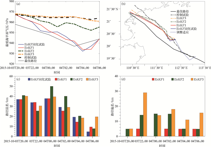
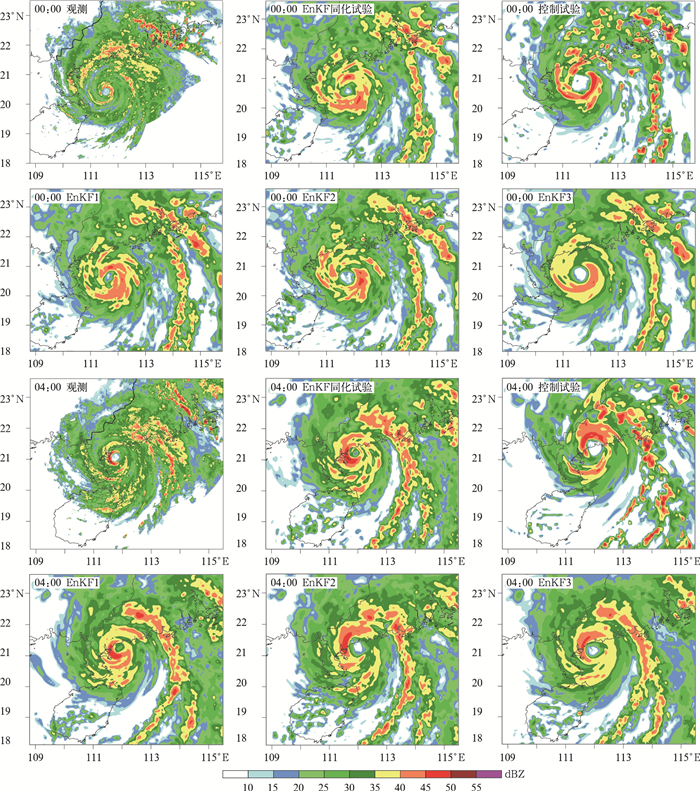
摘要: 基于WRF中尺度模式,采用集合卡尔曼滤波方法同化中国岸基多普勒天气雷达径向速度资料,对2015年登陆台风彩虹(1522)进行数值试验。从台风强度、路径、结构等方面验证了同化效果,并对不同区域雷达观测资料的同化敏感性进行讨论。试验结果表明:在同化窗内同化分析场台风位置误差相比未同化平均减小15 km,最多时刻减小38 km,同化资料时次越多,确定性预报路径误差越小。同化雷达资料后较好地反映出台风彩虹(1522)近海加强过程,台风中心最低气压同化分析和预报误差相比未同化最大减小超过25 hPa,台风眼的尺度、眼墙处对流非对称结构相比未同化与观测更加接近。试验还表明:台风内核100 km范围内的雷达观测对同化效果影响最大,仅同化这部分资料(约占总量的20%)各方面效果与同化全部资料相近,而仅同化100 km以外资料效果明显不及同化所有资料。仅同化台风内核雷达观测资料可以在不影响同化效果的前提下,使集合同化计算机时减小为原来的1/3,该策略可为台风实际业务预报提供一定参考。Abstract: Typhoon intensity and precise structure are hardly to predict by all kinds of numerical model, and one key problem is the lack of precise initialization data. Through a WRF-based ensemble Kalman filtering (EnKF) data assimilation system, impacts of assimilating China's coastal Doppler radar velocity observations for track, intensity and structure of Typhoon Mujigae (2015) is examined.Furthermore, assimilating sensitivity of observations in relative regions are also explored. The experimental results show that mean track error and max track error is reduced by 15 km and 38 km, respectively. The track error of the EnKF analysis becomes smaller with more cycles of assimilating data, and so do the deterministic forecast driven by EnKF analysis field. Through data assimilation, offshore enhancement process in Mujigae is well simulated. Intensity error in both EnKF analysis and prediction are smaller than 25 hPa after assimilation. After 9 h cycling radar velocity data assimilation, the deterministic forecast shows the typhoon continue to strengthen before landfall, and the typhoon eye is contracted much after data assimilation. The diameter of typhoon eye is reduced by about 70 km, and the eye wall convection asymmetric structure is closer to observation.The sensitivity of radar observation assimilation is tested by different radial distance area. Numerical sensitivity experiments show that radar observations within 100 km of the typhoon's inner core play a dominate role to assimilation results. Typhoon track, intensity and structure are all closer to observation by assimilating radar data within 100 km from typhoon center (about 20% of total observation) showing equivalent effects as assimilating all data. Typhoon is somewhat modified by cycling assimilating observations within 100-200 km from typhoon center. There is no obvious enhancement in typhoon track, intensity and structure after assimilating data 200 km away from inner core. Therefore, radar observation located in typhoon kernel is the key to determine assimilation effects. Because of less data assimilated, the strategy of only assimilating inner core radar data can reduce computing time to 1/3 of all data with somewhat same assimilation result. Efficiency of radar assimilation can be much improved by this radar assimilating strategy, and it can give reference to official typhoon real-time data assimilation and prediction work.
-
Key words:
- typhoon modeling;
- data assimilation;
- ensemble Kalman filtering;
- radar data
-
图 1 模拟试验设计方案(a)海口多普勒天气雷达(Z9898) 及其扫描覆盖范围与台风彩虹实测路径示意图(虚线表示资料同化时段), (b)模拟试验网格区域设置
Fig. 1 Experiment design of modeling (a)location of Haikou Doppler radar(site number is Z9898) and its radial velocity coverage with best track of Typhoon Mujigae(2015)(the dashed line denotes the period during which radar data is assimilated), (b)domain configuration of model
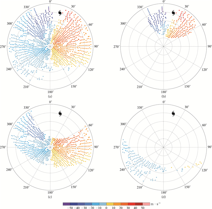
图 2 雷达超级观测资料分布(a)全部资料,(b)距台风中心小于100 km范围资料,(c)距台风中心100~200 km范围资料,(d)距台风中心200 km以外资料
Fig. 2 Scattering gram of super observations(SO) in assimilation experiments (a)total SO, (b)SO within 100 km from the typhoon center, (c)SO in 100-200 km from the typhoon center, (d)SO out of 200 km from the typhoon center
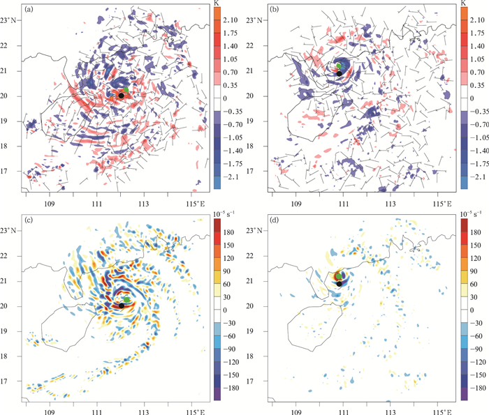
图 6 同化分析增量(a)2015年10月3日20:00 300 hPa位温增量(填色)和风矢量增量,(b)2015年10月4日04:00 300 hPa位温增量(填色)和风矢量增量,(c)2015年10月3日20:00 850 hPa涡度增量,(d)2015年10月4日04:00 850 hPa涡度增量(黑色圆点和绿色圆点分别表示观测和分析场台风位置)
Fig. 6 Analysis increments (a)300 hPa potential temperature increment(the shaded) and wind increment at 2000 UTC 3 Oct 2015, (b)300 hPa potential temperature increment(the shaded) and wind increment at 0400 UTC 4 Oct 2015, (c)850 hPa vorticity increment at 2000 UTC 3 Oct 2015, (d)850 hPa vorticity increment at 0400 UTC 4 Oct 2015 (black and green dots denote typhoon location of observation and analysis)
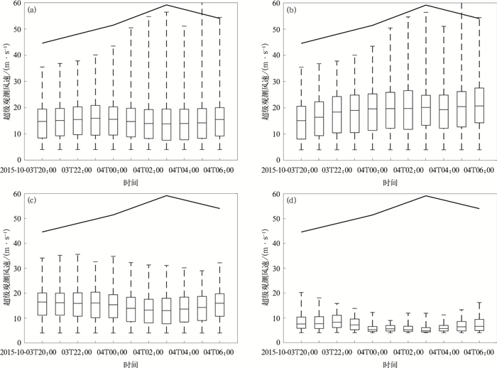
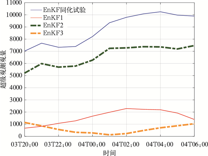
图 7 3组敏感性试验雷达超级观测资料盒须图(a)全部资料,(b)距台风中心小于100 km范围资料,(c)距台风中心100~200 km范围资料,(d)距台风中心200 km以外资料(折线为最佳路径近中心最大风速)
Fig. 7 Box-and-whisker plot of radar SO in assimilation experiments (a)total SO, (b)SO within 100 km from the typhoon center, (c)SO in 100-200 km from the typhoon center, (d)SO out of 200 km from the typhoon center(the black curve denotes the maximum wind speed from JTWC best track)
-
[1] Rappaport E N, Franklin J L, Avila L A, et al.Advances and challenges at the National Hurricane Center.Wea Forecasting, 1990, 24:395-419, DOI: 10.1175/2008WAF2222128.1. [2] Huang C Y, Wong C S, Yeh T C.Extreme rainfall mechanisms exhibited by Typhoon Morakot (2009).Terrestrial, Atmospheric and Oceanic Sciences, 2011, 22:613-632. doi: 10.3319/TAO.2011.07.01.01(TM) [3] Black M L, Gamache J F, Marks Jr F D, et al.Eastern Pacific Hurricanes Jimena of 1991 and Olivia of 1994:The effect of vertical shear on structure and intensity.Mon Wea Rev, 2002, 130(9):2291-2312. doi: 10.1175/1520-0493(2002)130<2291:EPHJOA>2.0.CO;2 [4] Liang J, Wu L, Ge X, et al.Monsoonal influence on typhoon Morakot (2009).Part Ⅱ:Numerical study.J Atmos Sci, 2011, 68(10):2222-2235. doi: 10.1175/2011JAS3731.1 [5] Lorenc A C.Analysis methods for numerical weather prediction.Quart J Royal Meteor Soc, 1986, 112(474):1177-1194. doi: 10.1002/(ISSN)1477-870X [6] Rabier F, Järvinen H, Klinker E, et al.The ECMWF operational implementation of four-dimensional variational assimilation.Ⅰ:Experimental results with simplified physics.Quart J Royal Meteor Soc, 2000, 126(564):1143-1170. doi: 10.1002/qj.49712656415 [7] 王曼, 李华宏, 段旭, 等.WRF模式三维变分中背景误差协方差估计.应用气象学报, 2011, 22(4):482-492. doi: 10.11898/1001-7313.20110411 [8] 杨艳蓉, 李柏, 张沛源.多普勒雷达资料四维变分同化.应用气象学报, 2004, 15(1):95-110. http://qikan.camscma.cn/jams/ch/reader/view_abstract.aspx?file_no=20040113&flag=1 [9] 李华宏, 薛纪善, 王曼, 等.多普勒雷达风廓线的反演及变分同化试验.应用气象学报, 2007, 18(1):50-57. doi: 10.11898/1001-7313.20070110 [10] 张新忠, 陈军明, 赵平.多普勒天气雷达资料同化对江淮暴雨模拟的影响.应用气象学报, 2015, 26(5):555-566. doi: 10.11898/1001-7313.20150505 [11] 施丽娟, 许小峰, 李柏, 等.雷达资料在登陆台风"桑美"数值模拟中的应用.应用气象学报, 2009, 20(3):257-266. doi: 10.11898/1001-7313.20090301 [12] 任强, 董佩明, 薛纪善.台风数值预报中受云影响微波卫星资料的同化试验.应用气象学报, 2009, 20(2):138-146. http://qikan.camscma.cn/jams/ch/reader/view_abstract.aspx?file_no=20090202&flag=1 [13] 高郁东, 万其林, 薛纪善, 等.同化雷达估算降水率对暴雨预报的影响.应用气象学报, 2015, 26(1):45-56. http://qikan.camscma.cn/jams/ch/reader/view_abstract.aspx?file_no=20150105&flag=1 [14] Mark B, Ron G, Oscar A, et al.Seamless Prediction of the Earth System:From Minutes to Months.Chapter 3.Data Assimilation Methods and Applications.2014. [15] Evensen G.The ensemble Kalman filter:Theoretical formulation and practical implementation.Ocean Dynamics, 2003, 53(4):343-367. doi: 10.1007/s10236-003-0036-9 [16] 梁晓, 郑小谷, 戴永久, 等.EnKF中误差协方差优化方法及在资料同化中应用.应用气象学报, 2014, 25(4):397-405. doi: 10.11898/1001-7313.20140402 [17] Whitaker J S, Hamill T M, Wei X, et al.Ensemble data assimilation with the NCEP global forecast system.Mon Wea Rev, 2005, 136(2):463-482. http://www.academia.edu/6232865/Ensemble_Data_Assimilation_with_the_NCEP_Global_Forecast_System [18] Zhang F Q, Weng Y H, Sippel J A, et al.Cloud resolving hurricane initialization and prediction through assimilation of Doppler radar observations with an ensemble Kalman filter.Mon Wea Rev, 2009, 137:2105-2125, DOI: 10.1175/2009MWR2645.1. [19] Wang M, Xue M, Zhao K, et al.Assimilation of T-TREC-retrieved winds from single-Doppler radar with an ensemble Kalman filter for the forecast of Typhoon Jangmi (2008).Mon Wea Rev, 2014, 142(5):1892-1907. doi: 10.1175/MWR-D-13-00387.1 [20] Yue J, Meng Z Y, Yu C K, et al.Impact of coastal radar observability on the forecast of the track and rainfall of Typhoon Morakot (2009) using WRF-based ensemble Kalman filter data assimilation.Adv Atmos Sci, 2017, 34(1):66-78, DOI: 10.1007/s00376-016-6028-8. [21] Houtekamer P L, Zhang F Q.Review of the ensemble Kalman filter for atmospheric data assimilation.Mon Wea Rev, 2016, 144(12):4489-4532. doi: 10.1175/MWR-D-15-0440.1 [22] Liu Z, Schwartz C S, Snyder C, et al.Impact of assimilating AMSU-A radiances on forecasts of 2008 Atlantic tropical cyclones initialized with a limited-area ensemble Kalman filter.Mon Wea Rev, 2012, 140:4017-4034, DOI:10.1175/ MWR-D-12-00083.1. [23] Xu D M, Liu Z Q, Huang X Y et al.Impact of assimilating IASI radiance observations on forecasts of two tropical cyclones.Meteor.Atmos Phys, 2013, 122:1-18, DOI: 10.1007/s00703-013-0276-2. [24] Aberson S D, Black M L, Black R A, et al.Thirty years of tropical cyclone research with the NOAA P-3 aircraft.Bull Amer Meteor Soc, 2006, 87:1039-1055. doi: 10.1175/BAMS-87-8-1039 [25] Weng Y H, Zhang M, Zhang F Q.Advanced data assimilation for cloud-resolving hurricane initialization and prediction.Computing in Science & Engineering, 2011, 13(1):40-49. http://ams.confex.com/ams/28Hurricanes/webprogram/Paper138595.html [26] Weng Y H, Zhang F Q.Assimilating airborne Doppler radar observations with an ensemble Kalman filter for convection-permitting hurricane initialization and prediction: Katrina (2005).Mon Wea Rev, 2012, 140:841-859, DOI: 10.1175/2011MWR3602.1. [27] Dong J L, Xue M.Assimilation of radial velocity and reflectivity data from coastal WSR-88D radars using an ensemble Kalman filter for the analysis and forecast of landfalling hurricane Ike (2008).Quart J Royal Meteor Soc, 2013, 139:467-487. doi: 10.1002/qj.1970 [28] Zhu L, Wan Q, Shen X, et al.Prediction and predictability of high-impact Western Pacific landfalling Tropical Cyclone Vicente (2012) through convection-permitting ensemble assimilation of doppler radar velocity.Mon Wea Rev, 2016, 144(1):21-43. doi: 10.1175/MWR-D-14-00403.1 [29] Xie B, Zhang F, Zhang Q, et al.Observing strategy and observation targeting for tropical cyclones using ensemble-based sensitivity analysis and data assimilation.Mon Wea Rev, 2013, 141(5):1437-1453. doi: 10.1175/MWR-D-12-00188.1 [30] Zhao K, Li X F, Xue M, et al.Short-term forecasting through intermittent assimilation of data from Taiwan and mainland China coastal radars for Typhoon Meranti (2010) at landfall.J Geophys Res, 2012, 117:D06108, DOI: 10.1029/2011JD017109. [31] Yue J, Meng Z, Yu C, et al.Impact of assimilating Taiwan coastal radar radial velocity on the forecast of Typhoon Morakot (2009) in Southeastern China using a WRF-based EnKF.Science China Earth Sciences, 2016, 59(1):1-13. doi: 10.1007/s11430-015-0259-y [32] Zhao K, Xue M, Lee W C.Assimilation of GBVTD-retrieved winds from single-Doppler radar for short-term forecasting of super typhoon Saomai (0608) at landfall.Quart J R Met Soc, 2012, 138:1055-1071. doi: 10.1002/qj.975 [33] 肖艳姣, 万玉发, 王志斌.多普勒天气雷达双PRF径向速度资料质量控制.高原气象, 2016, 35(4):1112-1122. http://www.cnki.com.cn/Article/CJFDTOTAL-GYQX201604024.htm [34] 肖艳娇, 万玉发, 王珏, 等.一种自动多普勒雷达速度退模糊算法研究.高原气象, 2012, 31(4):1119-1128. http://www.cnki.com.cn/Article/CJFDTOTAL-GYQX201204028.htm [35] Zhang F Q, Meng Z Y, Aksoy A.Tests of an ensemble Kalman filter for mesoscale and regional-scale data assimilation.Part Ⅰ:Perfect model experiments.Mon Wea Rev, 2006, 134(2):722-736. doi: 10.1175/MWR3101.1 [36] Meng Z Y, Zhang F Q.Tests of an ensemble Kalman filter for mesoscale and regional-scale data assimilation.Part Ⅱ:Imperfect model experiments.Mon Wea Rev, 2007, 135(4):1403-1423. doi: 10.1175/MWR3352.1 [37] Meng Z Y, Zhang F Q.Tests of an ensemble Kalman filter for mesoscale and regional-scale data assimilation.Part Ⅲ:Comparison with 3DVAR in a real-data case study.Mon Wea Rev, 2008, 136:522-540. doi: 10.1175/2007MWR2106.1 [38] Meng Z Y, Zhang F Q.Tests of an ensemble Kalman filter for mesoscale and regional-scale data assimilation.Part Ⅳ:Comparison with 3DVAR in a month-long experiment.Mon Wea Rev, 2008, 136:3671-3682. doi: 10.1175/2008MWR2270.1 [39] Zhang F Q, Weng Y H, Gamache G F, et al.Performance of convection-permitting hurricane initialization and prediction during 2008-2010 with ensemble data assimilation of inner-core airborne doppler radar observations.Geophys Res Lett, 2011, 38, L15810, DOI: 10.1029/2011GL048469. [40] Zhang F Q, Weng Y H.Predicting hurricane intensity and associated hazards:A five-year real-time forecast experiment with assimilation of airborne Doppler radar observations.Bull Amer Meteor Soc, 2015, 96:25-33, DOI: 10.1175/BAMS-D-13-00231.1. -


 设为首页
设为首页 加入收藏
加入收藏


 下载:
下载:
