Vol.15, NO.4, 2004

Display Method:
STUDY OF TRENDS IN RUNOFF FOR THE HAIHE RIVER BASIN IN RECENT 50 YEARS
Liu Chunzhen, Liu Zhiyu, Xie Zhenghui
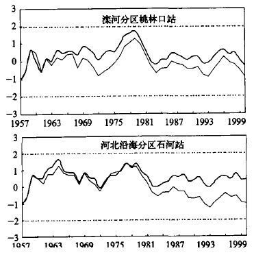
2004, 15(4): 385-393.
Abstract:
Mann-Kendall’s test was used to identify runoff trends for 20 sub-catchments located in the mountain area of the Haihe river basin in recent 50 years. Combining the in-phase analysis the decadal changes of precipitation, runoff and air temperature, and the sensitivity analysis of runoff to climate change, a semi-quantitative analysis approach was presented. By using this analysis method, the change trend and the attribution of natural runoff for the Haihe river basin can be summarized into three patterns: 1) Annual natural runoff has decreased significantly, of which the main factor is the dry and warming trend of the climate and the secondary is the anthropogenic activities; 2) Annual natural runoff has decreased significantly, of which the main factor is the anthropogenic activities and the secondary is dry and warning climate trend; 3) Annual natural runoff has no significant change trend, for the climatic variability and anthropogenic activities are not significant. This study reflects the interaction between climate, human activities and water. The mutual interaction causes complexities and difficulties to analye the change trend and attribution of runoff, and presents challenge to the impact study of climate change to water resources as well.
EFFECT OF TORRENTIAL RAIN ON VARIABILITY OF SUBTROPICAL HIGH
Zhou Bing, He Jinhai, Xu Haiming
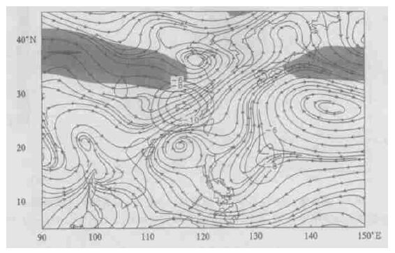
2004, 15(4): 394-406.
Abstract:
Based on NCEP/NCAP data sets and dynamical diagnostic, the meridional circulation fact of torrential rain over the mid-lower Yangtze reaches was presented with composite analysis. The downward flow of secondary circulation occurred obviously while deducting the day variety of perpendicular motion. With calculating complete form vorticity equations, the further results show that the negative vorticity is stimulated by diabatic heating over the high layer, which locates at west side of the heating center, and versus east side is positive vorticity. In the low layer there is opposite exactly. Finally, the analysis emphasizes that the subtropical high all will move along the local negative voeticity center for variety direction with South Asia High.
RETRIEVING REGIONAL SOIL MOISTURE OVER CHINA FROM SSM/I MICROWAVE DATA
Gu Songyan, Zhang Wenjian, Qiu Hong
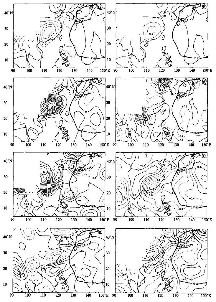
2004, 15(4): 407-416.
Abstract:
Remote sensing of soil moisture by microwave radiometry has been a subject of intensive studies in the past two decades. Following the studies done before, a new approach to retrieve surface layer soil moisture is accomplished, in which the passive microwave data from SSM/I, as well as AVHRR and ground observation data are used to retrieve surface microwave emissivity. The retrieved emissivity is further used to derive surface soil moisture. For getting the information about the mixed-pixel, the surface temperature, canopy percentage and surface roughness are involved, and the microwave emissivity of soil element in a pixel can retrieved. The emissivity of soil component in one pixel is better than average emissivity over the whole pixel when retrieval the surface moisture. The physical technique is also retrieved the surface microwave emissivity and surface moisture.
PARALLELIZATION OF THE SEMI-LAGRANGIAN SHALLOW-WATER MODEL USING MPI TECHNIQUES
Tian Hua, Bian Jianchun, Yan Hong
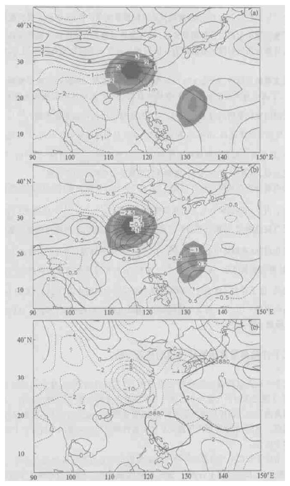
2004, 15(4): 417-426.
Abstract:
Parallelization of the semi-Lagrangian shallow-water model using Message Passing Interface (MPI) techniques was introduced. A detailed description of the 2-dimension semi-Lagrangian shallow-water model was made, and the model was successfully parallelized and implemented on the IBM SP2 computer, which is a distributed memory scalable parallel system.A semi-implicit semi-Lagrangian scheme, Ritchie scheme (nointerpolation), was introduced and adopted to deal with the advection term in the model, and the parallelization of the model was done by the method of standard Domain Partitioning Techniques (DPT). Special attention was paid to two key points: HALO and the parallel algorithm of Helmhotz Equation, in which the Odd-Even scheme was used. A number of comparative experiments were carried out to test the computation efficiency of serial and parallel model with different schemes.The experimental results show that higher parallel efficiency can be resulted in by the adoption of DPT. In the case of high resolution, the parallelization of semi-implicit semi-Lagrangian scheme is very efficient to cope with the advection term in the shallow-water model, and raises the computaion rate and the parallel efficiency.
CALCULATION OF MAXIMUM WIND VELOCITY RADIUS OF TROPICAL CYCLONE ON SEA SURFACE
Hu Bang hui, Tan Yanke, Wang Ju
2004, 15(4): 427-435.
Abstract:
By the agency of Fujita pressure formula, a method to calculate the maximum wind velocity radius of mobile asymmetric tropical cyclone (TC) over the sea in the circumstance that the strength keeps constant is developed in terms of the horizontal momentum equations with frictions in the polar coordinates after the reasonable simplification and derivation in the presence of the maximum wind speed. The result suggests that the maximum wind velocity radius will be large under the conditions that the maximum wind is small, the central pressure is low, the environmental air temperature and pressure are high, and the TC locates at a the low latitude or the friction coefficient is small, and vice versa. The maximum wind speed with minimum inner deflection angle resides at the right back side of the TC moving direction. The case studies of 9109 and 9115 TC indicate that the maximum wind radius increases in the initial stage of the TC development, decreases in the mature period, and enhances rapidly in the decay phase.
USING TRMM DATA TO ANALYSE THE PRECIPITATION DISTRIBUTIONS OF LANDFALL TROPIC CYCLONES IN GUANGDONG IN 2002
Ding Weiyu, Chen Zitong
2004, 15(4): 436-444.
Abstract:
The quality of quasi-global, near-real-time, TRMM-based precipitation estimates have been tested by automatic weather stations rainfall record in Guangdong Province, during the 3 tropical cyclones landfall periods in 2002. Results show that they have good relationship and the TRMM product can reveal the TCs 3-h temporal rain distributions. The temporal and spatial distributions of the TCs rain rate have been analysed, and the large scale circulation environment of these TCs have also been discussed. Results show that the radial distributions of the rain bands are changeable during the TCs landfall periods. Besides the low level moisture flux transmission and terrain, the inner region rain bands of TC Kammuri and Vongfong are weakened by the intensification of their outer region rain bands, that is similar to the former observation and research.
INVESTIGATION ON A SEVERE CONVECTIVE STORM MOVING RIGHT
Fan Hao, Wu Zhenghua, Duan Ying
2004, 15(4): 445-455.
Abstract:
Synoptic and dynamic conditions of a severe convective storm occurring in the plain of North China on 21 June 1998 were investigated. It was favorable for the occurrence of the storm. In addition, a warm-dry cover and the differential temperature advection between mid- and low- troposphere are quite important to the formation and development of convective instability, and to the accumulation of convective available potential energy as well. The genesis of convective clouds was triggered by the turbulence of westerly in the mid- to low-troposphere. Moreover, the convective clouds kept on developing during their process moving rightward. Such phenomenon was relevant to dynamic pressure vertical acceleration locating to the south of convective clouds, the import of the warm-wet air and the clouds combination.
PRELIMINARY RESULTS OF N2O FLUX MEASUREMENT IN LOW ATMOSPHERE AT RICE PADDY IN CHANGSHU USING CONDITIONAL SAMPLING
Ding Guoan, Liu Jingmiao, Yan Peng, Wang Muling, Wang Shufeng, Cheng Hongbing, Meng Zhaoyang, Cheng Yanjie, Lu Chang gui, Yu Haiqing, Wen Deyong, Xu Jing
2004, 15(4): 456-467.
Abstract:
In the period from 1999 to 2000, the N2O vertical flux in the low atmosphere during the main growing seasons of rice was measured using conditional sampling method over a rice paddy at Changshu Agriculture Ecological Station. The measurements indicate that N2O vertical flux was mainly between 0~2.0 mg·m-2·h-1, and the maximum daily averaged N2O vertical flux was observed in the afternoon. The N2O vertical flux in the transplant rice seedling period and reaping period was minimum among all the growing seasons. In these measurements, the minus N2O vertical flux also observed in some cases. The N2O vertical flux by conditional sampling technique was bigger than that measured by Chamber method reported in some domestic journal papers. The reason of this difference between the two methods needs further study.
CLOUD CLIMATOLOGY CHARACTERISTICS OF CHINA FROM ISCCP DATA
Liu Ruixia, Liu Yujie, Du Bingyu
2004, 15(4): 468-476.
Abstract:
Based on the cloud amount of ISCCP D2, the spatial distribution characters and the temporal variation of cloud amount over 3 regions of China were analyzed using system cluster analysis method. The variation trend of cloud over China was discussed. It concludes that in north east of China the cloud amount increases and decreases in the west of China and in the north of China. The singular value decomposition (SVD) modes based on two fields between winter total cloud amount over Tibetan Plateau and summer precipitation in China were computed and a credibility of teleconnection was analyzed by SVD. The result shows that the correlation between winter total cloud amount over Tibetan Plateau and the summer precipitation in the parts of north and northeast China is obvious.
AN ANALYSIS ON THE RELATIONSHIP BETWEEN THE ECOLOGICAL CHANGE AND SANDSTORM IN THE DROUGHT ZONE OF MIDDLE NINGXIA
Zhao Guangping, Chen Nan, Yang Jianling, Li Yanchun, Wu Jiamin
2004, 15(4): 477-484.
Abstract:
The year-to-year quantificational change characteristics in Yanchi county of the drought zone of the middle Ningxia where occurred sandstorm frequently in the 1990s were revealed on the whole by using TM remote sensing and land survey data. Analyzed results show that ecological condition in Yanchi county in the early 1990s was obviously better than that in the late 1990s. Drought was mainly reasons caused ecological change. Human activity, such as land over-cultivated on a large scale, over-pasturage and digging the liquorice in excess, however, was another important reason. It was the situation of ecological environment became worse and worse in whole and got better in part that caused the fall in threshold of dust-blowing. The probability of sandstorm occurrence had been increased remarkably in the drought zone of middle Ningxia in the past 30 years according to the analysis of the cause of sandstorm and by mean of synthetically analysis of individual cases of thirty-year sandstorms in Yanchi county. Due to those: climate, water resource shortage and land overloaded etc which caused desertification in western China would not be improved in predictable longterm period in future, moreover, ecological environment is frangible, easy to ruin and difficult to resume, and with the objective quantificational analysis on data, we put forward a point the first time of that the probability sandstorm occurrence in western China would be in the ascending situation from now on.
THE APPLICATION OF PERFECT PROGNOSIS METHOD TO GALE WIND ALONG THE GUANGDONG COAST WINTER
Lin Liang xun, Cheng Zhengquan, Zhang Bing, Hu Situan
2004, 15(4): 485-493.
Abstract:
Based on the gradient wind theory and the statistical data of pressure field and the representative stations’winds along the Guangdong coast from 1990 to 1999, a new objective method, the perfect prognosis method, which reveals more obvious relations between the ground pressure field patterns and the winter gale wind than used to be, is proposed to distinguish the ground pressure field patterns, choose empirical factors and forecast winter gale wind along the Guangdong coast in the application of the JMA’s NWP products. The method was used in real-time operation forecast of gale wind from 2001 to 2002, the result shows that the method is capable to forecast gale wind in winter along the coast.
STUDY OF WATER FLOODING MODEL OF POYANG LAKE BASED ON BASIN PRECIPITATION
Huang Shue, Zhong Maosheng
2004, 15(4): 494-499.
Abstract:
Based on the study of the precipitation of water systems impacting on water level of Poyang Lake in some water seasons, a forecast model of water level changing with precipitation is developed. Using the analysis results of water area of remote sensing monitoring and water level of Poyang Lake in the same time in lately ten years, the water flooding model of Poyang Lake much water season is studied. And solved a trouble that meteorological satellites can not monitor the water area in water flooding time in cloudy weather. Through checking up the modeling results, it is proved that the modeling effects are good after quitting cultivation and resuming lake in Poyang Lake area, the relative difference between modeling value and remote sensing monitoring data are from 0.9 to 3.6 percent.
CLIMATOLOGICAL ASSESSMENT ON BASIC SIMULATED RESULTS OF GISS ATMOSPHERE-OCEAN COUPLED MODEL
Zhou Botao, He Jinhai, Chen Long xun, Zhao Ping
2004, 15(4): 500-505.
Abstract:
GISS Atmosphere-Ocean coupled model is briefly described. Some simulation is conducted by using the model to judge its ability of climate simulation especially for Asian region. The results show that the simulated climatology of atmosphere over Asian region and ocean is close to the observation, which indicates that the model can be used for the study of climate change. Due to its coarse resolution and low requirement on computer resource, it is easy to run on the middle or small scale computer. Some defects of the model is also discussed, which need to be improved such as low surface temperature simulated in Asian region, high sea temperature, high rainfall on the south side of the Qinghai-Xizang Plateau and low precipitation in North China in Summer and so on.