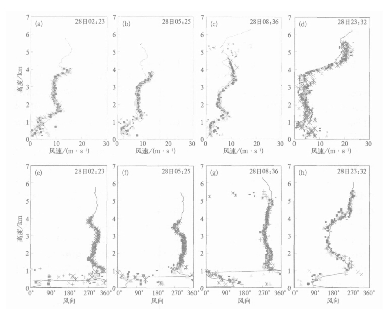
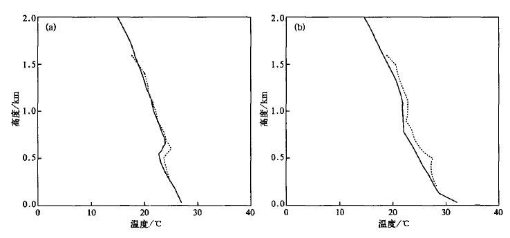
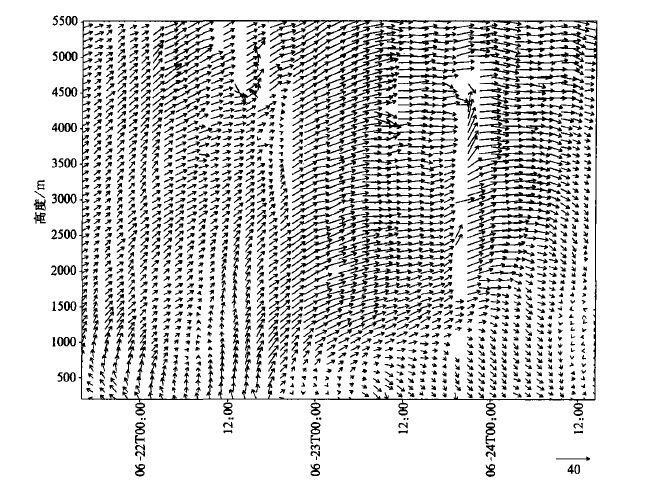
Vol.16, NO.5, 2005

Display Method:
THEORETICAL STUDY ON IMPACTS OF SOME LAND SURFACE ELEMENTS HETEROGENEITIES UPON MODEL OUTPUT
Zhang Zhengqiu, Zhou Xiuji, Li Weiliang, Sun Shufen
2005, 16(5): 561-568.
Abstract:
By means of averaged parameterization, a theoretical study is concerned with influences of the heterogeneous distributions of surface temperature, roughness, snow depth and density on their calculated physical quantities.Results indicate that with the surface temperature heterogeneity taken into account, gridded averaged long w ave radiation flux is increased and so is the saturation vapor pressure at surface, which is mo re sensitive to the temperature inhomogeneity compared to the radiation flux for the same coefficient of variation in the temperature distribution and constant temperature condition ;the heterogeneity of surface roughness exert s some impacts on neutral drag coefficient and BATS snow coverage and so does the inhomogeneity of snow depth and density on snow coverage .Key
ANALYSIS OF THE MESO-β CONVECTIVE CLOUD CLUSTER OVER MEIYU FRONTON 3 JULY 2003
Fang Zongyi, Xiang Xukang, Fang Xiang, Li Xiaolong
2005, 16(5): 569-575.
Abstract:
In term of meteorological satellite sensing data and processed products, the mesoscaleaspects of a rainstorm system occurred over the north of An hui province on 3 July 2003are analyzed.It suggests that there are 11 meso-β convective cloud cluster developed with 100 km in spatial scale and 5 h in time scale.High humidity, positive vorticity and upwardcurrent, which lead to the energy release of the high humidity baroclinic instability and the development of meso-β cloud cluster, help making for the environment for heavy precipitation.The other characters making for heavy precipitation is that the high contents of ice for potential precipitation and ice in cloud on the upper of the water coagulation profile of clouds with the maximum of 0.8 k/kg, the highest height 18 km, and the brightness temperatureon the top of these clouds under-80 ℃.
EXPERIMENTS WITH ATMOSPHERIC TEMPERATURE PROFILE RETRIEVAL FROM FY-3A IRAS SOUNDINGS
Qi Chengli, Dong Chaohua, Zhang Wenjian, Zhang Fengying, Zhang Peng
2005, 16(5): 576-582.
Abstract:
To investigate the performance of InfRared Atmospheric Sounder (IRAS)aboard the satellite FY-3A, the retrieval of the vertical profile of atmospheric temperature is studied based upon the IRAS channel spectral characteristics in i ts initial design and the spectral response function of the spectrometer.The retrieval is performed using different combinations of channels for 15 μm CO2absorption bands of the IRAS, indicating that on the w hole the sounder produces higher retrieval and inclusion of channel 8 leads to the remarkable improvement of retrieval precision of near-surface-layer temperature.For the retrieval from an iterative algorithm the first guess profile affects the precision greatly, and the closer the estimated profile to the t rue value, the higher the accuracy.The designed channel sensitivity meets the required needs of such retrieval.Low sensitivity leads to lowered precision.As a result, the retrieval precision depends strongly on the IRAS sensitivity.
VARIATION OF DUST WEATHER AND ITS CLIMATIC ATTRIBUTION ANALYSIS IN NORTHERN PARTOF CHINA
Zhang Li, Ding Yihui, Ren Guoyu
2005, 16(5): 583-592.
Abstract:
Based on the surface observations from 1954 to 2001, the tendency of dust weather frequency is presented by Mann-Kendall method, and the relationships of the frequency tow ind, relative humidity, air temperature and dryness index are analyzed.The Geopotential height in 1000 hPa from NCEP/NCAR reanalysis data is used to study the pressure gradient change in winter and spring from 1954 to 2001.Results show that the direct natural causes of dust weather frequency change in the recent 50 years include the decrease of daily mean wind speed, the decrease of number of day s with daily mean w ind speed higher than 5.0 m/s, the increase of precipitation in the same spring and last w inter, and the improved condition of atmosphere and soil moisture in some potential dust resource areas.Results also show that decrease of pressure gradient in winter and spring influences dust weather frequency by affecting w ind speed indirectly.
LONG-TERMVARIATION PATTERN AND FUTURE TREND OF PRECIPITATION IN THE VALLEYS OF SONGHUAJIANG AND LIAOHE RIVERS
Li Xiang, Li Weijing, Zhao Zhenguo
2005, 16(5): 593-599.
Abstract:
Study on the precipitation variation features for the valley s of the Songhuajiang and Liaohe rivers is undertaken by means of a t rend analysis, power spectral method and wavelet transform in terms of the monthly and seasonal precipitation data from 1881 to 2002.Results indicate that a remarkable interdecadal variation is inherent in the precipitation of the target region, dominated by 27-30 (35-38)year periods for the rainfall in the Song hua jiang (Liaohe)valleys.Based on the evolution of the rainfall itself and auto-regression estimationitis inferred that the former (latter)w ill remain in a drier (a still longer rain-deficient)stage in 5-10 years to follow.
THE PRELIMINARY STUDY ON MEASURED RESULTS OF AMBIENT VHCs IN BEIJING AREAS
Wang Mulin, Cheng Hong bing, Ding Guoan
2005, 16(5): 600-607.
Abstract:
The variation of atmospheric concentration of C2~C10 volatile hydrocarbon compounds (VHCs)is measured out in Beijing areas using Tenax TA and Carbosieve sorption-thermodesso rption-capillary gas chromatography.113 samples are collected during the period of September 2001 to August 2003.55 VHCs species are detected including 26 alkanes, 19 alkenes and 10 aromatics.The average mass concentration of VHCs is 364.3 ±99.3 μg/m3. The seasonal peak value is 546.9 ±353.5 μg/m3w hich appears in autumn.The valley value appears in summer which is 251.8 ±152.4 μg/m3.The VHCs average concentration is 30% in the heating season more than that in the non-heating season.The average concentration in the urban area is 10% higher than that in the suburbs.There are the significant daily variations of VHCs in Beijing.Results show that the polluted levels of ambient air depended mainly on the vehicle emissions and the meteorological conditions.
ANALYSIS OF THE DATA QUALITY OBSERVED BY THE CHINESE-MADEOZONE SONDE SYSTEM
Zheng Xiangdong, Li Wei
2005, 16(5): 608-618.
Abstract:
Quality analysis on the vertical distribution data observed by the Chinese-made ozone sonde system over Beijing from April 2001 to September 2004 is presented.The basic parameters observed by the system including the temperature of electronic chemistry cell in the sonde, the maximum of atmospheric ozone partial pressure and its altitude, the temperature and altitude of tropopause indicate that the stability of the sonde system needs to be improved.The integrated column ozone from the sonde system is generally higher than that of observed by the ground-based Dobson spectrophotometer, and the difference of them is with-in ±20% from 2002 to 2003.11 times simultaneous comparison measurement s show that the ozone partial pressure below 15 km and in 25~30 km observed by Chinese-made ozonde sonde system are higher than that observed by the ECC ozone sonde system with double cells which is extensively used.Also, the result suggests that the Chinese-made ozone sonde system participate the international calibration campaign organized by the Global Atmospheric Watch World Meteorological Organization(GAW/WMO).Wi th the certain technological availability, the single cell in Chinese-made ozone sonde system is recommenede to be updated by double cells.
ERROR ANALYSES OF DAYTIME METEOROLOGICAL VISIBILITY MEASUREMENT USING DUAL DIFFERENTIAL LUMINANCE ALGORITHM
Lu Weitao, Tao Shanchang, Tan Yongbo
2005, 16(5): 619-628.
Abstract:
The theoretical analyses of measurement error caused by non-standard viewing conditions, and the corresponding error-control methods through using a Dual Differential Luminance (DDL)algorithm in daytime meteorological visibility measurements are presented based on digital photography.It show s that :(i)the vertical relative gradients of sky luminance near due south and north horizons are mostly in the range of 4%/°~10%/°bigger than horizontal ones, which are mostly less than 2%/°, except at noon in sunny day or w hen the homogeneous cloud layer spreads over the w hole sky.The deviation angles between sight paths of different target-backg rounds can bring much bigger measurement errors and their effects should no t be neglected.The best solution is to set targets with same viewing elevation angle and to restrict the viewing azimuth angle deviations as small as possible during the operations of Digital Photography Visiometer System (DPVS).With the important advantage of matrix imaging technique, there is the possibility to further reduce their effects if the sky luminance along the same sight path of a given target is interpolated from the luminance distribution of the sky at both sides of the target.(ii)The nonuniform illumination along the sight path is also a measurement error source, which can' t be cont rolled manually.It is preferred to choose a site field with more uniform surface.And the error can also be reduced to a certain ex tent through averaging multi-samples.It is feasible to avoid result s with muchbigger error by monitoring the luminance distributions of site and sky and recognizing worse illumination conditions in real time.(iii)Observing some dark target s, such as trees, grasses, mountains, w alls and window s etc., can' t satisfy the demand of DDL measurements.I t is an optimal solution to adopt artificial black target s which have enough low reflectivity.
OBSERVATION OF CLOUD BASE HEIGHT THROUGH DOUBLE LOCATION DIGITAL PHOTOGRAPHY SYSTEM
Tan Yongbo, Tao Shanchang1, Lǜ Weitao, Liu Yifeng
2005, 16(5): 629-637.
Abstract:
It is an extremely important and valuable work to develop advanced remote sensing system of macrophysical and microphysical cloud characters.A new method is proposed to observe cloud base height through g round-based double location dig ital photography system.In this system, cloud height is calculated in real time from displacement between two matching templates which are automatically searched from two all-sky nephog rams.Consistency is show n between cloud heights observed through double location and those through lidar in Luogang airport of Hefei.According to measurement error of cloud height, the observation should be performed under the preferential observing condition with baseline length as long as possible but less than 200 m, and angle of view variable in ±45°.Furthermore, the excellence and limitation of this method are discussed.
SPATIAL AND TEMPORAL CHARACTERISTICS OF CLOUD-TO-GROUND LIGHTNING IN SUMMER IN BEIJING AND ITS CIRCUMJACENT REGIONS
Zheng Dong, Meng Qing, Lǜ Weitao, Zhang Yijun, Chai Xiumei, Ma Ming
2005, 16(5): 638-644.
Abstract:
In terms of the observations from M-LDARS single stat ion lightning location system, the spatial and temporal characteristics of cloud-to-ground (CG)lightning activities in Beijing and its circumjacent regions are studied.The temporal distribution of CG lightning occurrence has two peak periods, one is from 13 :00 to 21 :00 (BT), the other is from 23 :00 to the next 05 :00 (BT).By analyzing the densities of total CG lightning and CG lightning during the different periods and peak periods, several areas with strong lightning activities are found.These areas are located over the mountains or over w atersheds.Furthermore, lightning activities are much associated with water vapor condition of underlying surface.It is also found that there is obvious difference between the spatial distribution of positive CG lightning activity and negative CG lightning, indicating the difference in the charge structure of storms.
PRELIMINARY RESEARCHES ON THE RELATIONSHIP BETWEEN ANOMALOUS WINTER MONSOON CIRCULATION OVER EAST ASIA AND FLOOD/DROUGHT FROM APRIL TO JUNE IN GUANGDONG
Zeng Cong, Hu Situan, Liang Jianyin, Lin Liangxun, Xie Jiong guang, Ji Zhongping, Li Xiaojuan, Yi Aimin
2005, 16(5): 645-654.
Abstract:
Based on 500 hPa geopotential height fields and mean position of East Asian trough, a definition of the East Asian winter monsoon index(I500)is given.The analysis ofI500that the winter monsoon undergo a pronounced reduction during the past 50 years.Since the year of 1987, the winter monsoon has become rather weakened.Using the seasonal precipitation data of 48 stations in Guangdong from 1954 to 2004, the grades of drought and flood from April to June are marked off and analyzed by the regional drought and flood index (W-index). Results show that there are nine severe flood years and ten severe drought years in the past 51 years.The effect of abnormal w inter monsoon on the precipitation from April to June is obvious.The strong East Asian w inter monsoon usually leads to severe drought.
ANALYSIS OF THE ABRUPT RAINSTORM IN NORTH SHAANXI IN RELATION TO TYPHOON FAR AWAY
Jing Xi, He Wenbin, Bi Xu, Ai Lihua
2005, 16(5): 655-662.
Abstract:
Diagnosis is performed of the abrupt rainstorm on 4 —5 July, 2002 in Zichang County of north Shaanxi Province under the influence of a far-away typhoon.Result s suggest that the rainfall event happens due to the repeated occurrence of a meso-β intensely convective cluster moving over the study county.Obviously, the interactions between weather systems at low and middle latitudes are responsible for the moisture, instability, dynamic condition and a synoptic circulation background that favor the genesis, development and repetitive occurrence of the meso convective cloud cluster over the study county.Diagnostic study of moist potential vorticity (MPV)indicates that the typhoon traveling toward the northwest leads to the fact that 1)the low-level negativeMPV1 intensif ication is accompanied by the positiveMPV1 enhancement in the higher troposphere, thereby creating a condition for the accumulation of unstable energy in large amounts at lower levels ;2)the rainstorm area gives rise to the favorable dist ribution of MPV barotropic and baroclinic terms in vertical answerable for the generation and development of the cloud cluster ;3)the area of close-together MPV2 contours at the 850 hPa level is coupled with the MPV1=-2 PVU meso convectively unsteady co re, which is clearly indicative of the production and evolution of the cluster downstream of the coupling.Diagnosis also show s that w hen the typhoon moves north by east the instability occurs at lower and high levels over the rain zone ;the area ofMPV2 close-together contours at 850 hPa moves eastward and positiveMPV2 is intensified, resulting in dramatic release of accumulated convectively unsteady energy in the study county.
AN APPROACH TO A PROGNOSTIC FACTOR OF BASIN RAINFALL IN SUMMER OVER THE SONGHUAJIANG-NENJIANG-LIAOHE VALLEYS
Chen Lijuan, Zhang Peiqun, Zhao Zhenguo
2005, 16(5): 663-669.
Abstract:
By use of 45-station rainfall from the Song hua jiang, Nenjiang and Liaohe (SN L)river v alleys and NCEP/NCAR reanalysis, study is made of the climate features of the summer basin rainfall over the valley s and the forerunner relative to the anomaly, proposing a qualitative prediction scheme for a flood or drought trend based on the Northern Hemisphere circulation anomaly in the previous November and December.The scheme introduces two indices for the anomaly of extratropical circulations, with which to satisfactorily discern and predict the singularities of the basin precipitation in summer.
ANALYSIS OF GLOBAL TOTAL CLOUD AMOUNT VARIATION OVER THE PAST 20 YEARS
Ding Shouguo, Zhao Chunsheng, Shi Guangy u, Wu Chun' ai
2005, 16(5): 670-677.
Abstract:
Cloud plays a crucial role through modulating the radiation budget and water cycles in the earth' s climate system, thus influences the climate significantly.Global warming accelerates over the past 20 years, analyzing global cloud amount variation during this period can not only promote the understanding to the interaction between the cloud and climate but also help to guide the development of the climate model.By investigating the International Satellite Cloud Climatology Project (ISCCP)D2 dataset, results show that the cloud amount distribution is mainly affected by the atmospheric circulation, and the global mean total cloud amount is about 67%;increasing trend of global annual mean cloud amount reverses in 1987 and there is a decrease trend for global mean total cloud amount with the deduction of about 4% from 1987 to 2000 ;also, the cloud amount distribution takes on remarkable regional features, which tends to decrease in most tropical and mid-latitude areas while increase slightly in high-latitude, especially over the Antiarctic.
THE APPLICATION OF CLOUD PHASE RECOGNITION BY MODIS SPECTRAL DATA
Zhou Zhuhua, Bai Jie, Liu Jianw en, Ji Fei, Qi LinLin, Li Wei
2005, 16(5): 678-684.
Abstract:
The basic principle of MODIS multispect ral cloud phase recognition is introduced, with the algorithm for cloud phase recognition investigated.Radiosonde observations and MODIS tri-channel composite images are used in the paper to show the rationality and the effect of cloud phase recognition in cases.The analysis of large cloud scenes in some special weather background indicates that the technique of multispectral cloud phase retrieval is quite steady to be applied in practice and some visible techniques should be imported to reduce the error which is unavoidable in the analysis of multilayer mask and thin cirrus with inf rared technique.
THE APPLICATION OF A LIQUID CARBON DIOXIDE SEEDER
Fan Peng, Yu Xing, Lei Hengchi, Chen Baoguo, Liang Gu, Yue Zhiguo, Zhang Xiaoqing
2005, 16(5): 685-692.
Abstract:
The primary features, seeding rate and main dominant factors of the liquid carbon dioxide seeder are described.The phase, particle shape and size spectrum of particles from the seeder are measured by probes of such instruments as FSSP-100, 2D-C, threefold drop-size meter and visibility detector.Measurements show that effluents from the seeder are a mixture of vapor, liquid and solid substances of CO2.The lifetime of liquid and solid particles at 10-1to 102μm in diameter ranges over 100to 101second.The mass per unit volume of the effluent reaches 3.6 g·m-3.These measurements provide a reliable basis for liquid carbon dioxide as catalyst in cold clouds, which is a catalysis technique suitable for artificial rain enhancement in warmer strati form clouds in our country.
THE ATMOSPHERICWIND PROFILER AND RADIO ACOUSTIC SOUNDING SYSTEM WITH ITS APPLICATIONS
Wang Xin, Bian Lingen, Peng Hao, Li Jiandong
2005, 16(5): 693-698.
Abstract:
Based on the system structure and basic principle of atmospheric Wind Profiler and Radio acoustic sounding system (WPR)being introduced, observations by WPR are compare with those by the radiosonde.The evidence suggests that observat ions of WPR are authentic.Furthermore, convective characteristics and vertical structures of mesoscale precipitation from Meiyu fron tare analyzed with wind speed and wind direction observations of atmospheric wind profiler.Results also show that the vertical structure of wind detected by atmospheric wind profiler is better, it canreal-time monitor vertical shear and convective characteristics of w ind during mesoscale precipitation, and it can improve accuracy of the rainfall forecasting too.
MESOSCALE ANALYSES OF A SICHUAN HEAVY RAINFALL
Jiao Meiyan, Li Chuan, Li Yanxiang
2005, 16(5): 699-704.
Abstract:
A diagnostic study on a severe rainfall occurred over the northeast of Sichuan province in 3 —5 September 2004 is undertaken with the rainfall characteristics, large scale circulations and the meso-scale synoptic systems presented.Results show that wind shear at the east part of Tibetan Plateau and southwest vortex at the lower level in the basin of Sichuan play the key role in the occurrence of the heavy rainfall.The convective activities and the heavy rain mainly occurrson the sharp wind shear which locates over the east of the vortex center.The very strong vertical velocity is detected which is sustainable by two second vertical circulations located respectively at the north and south of the southeast vortex.