Vol.18, NO.2, 2007

Display Method:
Abnormality of Summertime Precipitation of Eastern China and General Circulation with LFO in 1998
Zhou Bing, Wen Jifen
2007, 18(2): 129-136.
Abstract:
Abnormality of summer monsoon circulation in East Asia has special impact on the precipitation in target area, and the low frequency precipitation is an important character of the monsoon. By use of the SCSMEX in situ observational precipitation data and NCEP/NCAR reanalysis data sets, the observed facts related to the abnormality of the precipitation and the related low frequency variability in 1998 are revealed, and the following results are obtained mainly. It is found that the second stage of Baiu come forth in Yangtze River area during the flood season in 1998, 10—20 d low frequency fluctuation exists universally, but 30—50 d one has a regional character. The abnormality of the precipitation in the area of Yangtze River is caused by the abnormity of the location of the west Pacific subtropical high, the abnormity of the persistence blocking high over mid latitude Eurasian land, the abnormity of upper air westerlies jet stream axis, and the second stage of monsoon surges and their interaction. The regional torrential rainfall periods include two stages, the first period is from June 12 to June 26, and the second period begins on July 17 till August 9. The division can pass the significance test for α=0.01. In 1998, the maximum entropy spectrum analysis of the summertime precipitation shows that the preferred period of more than 20 days is of only 4% of the stations during the analysis area(about 136 stations), and the preferred period of less than 10 days is of 31% of the stations, so the primary preferred period is 10—20 days near the East Asia monsoon active region. There are two high percentage areas of mean square error for 10—20 days low frequency oscillation in the target area, and two weeks fluctuation period is an important phenomenon in the flood year, so torrential rainfall cluster occurring time is a main phase of low frequency precipitation. Evidence suggests that the location of the west Pacific sub tropical high has two staggered northwards, and three times rapidly southward withdraw, whereas the location is a little southward in general. Morlet wave period analysis confirms that the sub tropical high ridge line has a low frequency oscillation character, and 10—20 days period occurs in May, and two kinds of LFO period appear from June to August. Meanwhile, the persistence blocking high over mid latitude Eurasian land is strong during 2 torrential rainfall stages, while the cold air can easily move southward, and mid high latitude circulation abnormality looks like i n 1954. Upper level westerly jet rapidly jumps northward near 50°N in early May, and one week late, the location of the jet axis withdraws southward. Since middle July, 200 hPa zonal wind axis has 5—8 latitude distance than normal years. At the same time, two times monsoon surges can be found, the θse and southerly have staggered intensities.
Influences of the East Asian Jet Stream on Winter Climate in China
Mao Rui, Gong Daoyi, Fang Qiaomin
2007, 18(2): 137-146.
Abstract:
The European Center for Medium Range Weather Forecasts reanalysis data sets and the observed data for precipitations and temperatures in China are used to depict the relationships between the eastern China climate and the East Asian jet stream (EAJS). With an emphasis on the northern winter seasons and on the interannual timescales, the variations of the intensity and the meridional displacement of EAJS and their relationships with the precipitations and temperatures are analyzed, and the relative connections of the EAJS and the winter monsoon to the anomalies of atmospheric circulation in the eastern China region are assessed. The intensity index(normalized mean u200 averaged over 30°—35°N, 127.5°—155°E)and the shear index of EAJS (normalized u200 difference between two areas over 15°—25°N, 100°—115°E and 30°—40°N, 100°—115°E) are first defined, which can reasonably reflect the interannual variation of the intensity and meridional displacement of EAJS, then relative connections of intensity index and shear index with winter temperatures and precipitations in China for period 1957—2001 are investigated respectively. The correlation coefficient between the intensity index and the shear index is -0.48 (exceeding 99% confidence limit), which means that when EAJS intensifies the meridional displacement of EAJS is abnormally southward. It is found that the intensity of EAJS is associated with the extensive atmospheric circulation in Asia and west Pacific, while the meridional displacement of EAJS does strongly link to the atmospheric circulation in the tropical central eastern Pacific and the Indian Ocean. The possible way of winter EAJS affecting the precipitation and temperature of China can be described as follows: At the left side of the entrance region of EAJS the pressure of low level atmosphere increases due to the convergent flows, meanwhile at the left side of exit region of EAJS the pressure of low level atmosphere decreases because of the divergent flows. So in the mid lower level of the troposphere the pressure over Mongolia and Siberia increases and that over the north Pacific decreases, which results in both the difference between them increasing and the East Asian trough deepening. The increased difference of geopotential height between land and sea and the intensified East Asian trough may make winter monsoon intensify, resulting in the drop of temperature in the east part of China, meanwhile there are descending flows over the 30°—40°N that make the precipitation decrease over the northern China, the middle China and the mid lower reaches of the Yangtze River. When EAJS weakens abnormally and the displacement of EAJS is abnormally southward, the south wind occurs in the whole East Asia indicating the weak winter monsoon, while there are ascending flows over the east part of 25°N. At that time the precipitation in the southern China, Inner Mongolia and the northern China increases, and the temperature of Inner Mongolia is high abnormally.
Meiyu of the Huaihe Basin in Recent 52 Years
Xu Qun, Zhang Yanxia
2007, 18(2): 147-157.
Abstract:
Climate data show that the Meiyu period exists not only in the mid lower Yangtze Basin (MLYB), but also prevails in central southern part of the Huaihe Basin. Then using the daily rainfall data of 5 stations evenly distributed in the latter region with the consideration of seasonally moving process of the pentad ridge's line of west Pacific high, Meiyu periods of the Huaihe Basin (HB) in recent 52 years (1953—2004) are delimited. They are very significant as the same exist in the MLYB, their average onset and ending dates are June 25 and July 21, later than the average Meiyu periods of MLYB by 5 days and 7 days respectively. However the inter annual changes of the HB Meiyu are large, the range of onset days reaches 41 days and the amplitude of ending dates approaches 2.5 months in the recent 52 years. In 8 years (occupying 15.4%), the HB Meiyu are absent, but plenty numbers of the HB Meiyu(exceeding the average value of more than 20%)also occur in 18 years (occupying 34.6%). As early Meiyu period (EMP) has appeared in MLYB, it also occurs in Huaihe Basin during 5 years, they arethe certain kind of Meiyu periods appearing abnormally early in May, however after they end, the summer monsoon rain belts of east China (SMRBEC) retreat to south un til the beginning of the main Meiyu period in June/July. The inter annual change of the HB Meiyu plays a key role which causes the summer trend of whether drought or flood in these regions. Most anomalies of the Meiyu amount both in the Huaihe Basin and in the MLYB have the same sign; however the opposite signs to each other have appeared in 1/4 of the cases. The inter annual changes of the HB Meiyu have enhanced since late 1970s, such abrupt change of the HB Meiyu means the weak condition with earlier ending dates in former stage abruptly transforms into a new stage around 1979, having the following characteristics:higher amount of HB Meiyu with later ending dates accompanied by strong short waves of 2.2—2.3 years. The average HB Meiyu amount of the latter 26 years since 1979 is higher than the former 26 years by nearly 30%, such contrast is especially significant between the following 2 stages:the anomalous weak HB Meiyu in 1958—1966 and the anomalous plenty HB Meiyu in 1979—1987. From the point of atmospheric circulation, it is found that the July coastal trough (at 500 hPa level) in the mid latitudes of East Asia (JCTEA) tends to move southward more frequently since 1979, then the west Pacific high and its northern SMRBEC retreat accompanied by the delay of HB Meiyu and the higher amounts. Such JCTEA has bigger influence on the HB Meiyu and its ending dates than those of either Okhotsk high or Ural high. First analysis shows that the abrupt change since 1979 may be closely associated with many effects of anthropogenic activities in different scales, such as the enhanced global warming, the increasing smoke and dusts over central eastern China due to the acceleration of industrialization etc.
Case Study on Cloud Properties of Heavy Rainfall Based upon Satellite Data
Liu Jian, Zhang Wenjian, Zhu Yuanjing, Dong Chaohua, Zhao Bolin
2007, 18(2): 158-164.
Abstract:
Heavy rainfall is one of meteorological disasters in China. Precipitation has complex spatial and temporal distribution. It is difficult to get 3 dimension information by regular observation method. Remote sensing is a kind of useful ways to monitor precipitation. Weather satellites have high space and time resolution which are becoming a kind of important measurements. Cloud is one of key factors to produce precipitation. To do research on heavy rainfall, it is needed to understand cloud properties well.It is important to investigate the relationship between clouds and strong precipitations and try to reveal kinds of cloud properties which can produce heavy rainfall by satellite data. Visible, infrared and microwave data of FY-1D, EOS and NOAA satellites are used to analyze cloud properties of the heavy rainfall case. Visible and infrared radiance data have high spatial resolution, and can be used to show the detailed property information of small convective cloud. But properties of cloud on visible and infrared channel don't have clear relationship with precipitation. In the atmosphere, rain particles have strongereffect than clouds on microwave. Rain particles also absorb and re-emit more radiance than cloud particles. Compared with visible and infrared data, microwave data can show the structure properties of strong precipitation cloud, although its spatial resolution is low. So it is very helpful to monitor 3 dimension properties of convective cloud if these different kinds of data can be combined together. Cloud phase, cloud optical thickness and cloud vertical structure are selected as analysis physical parameters. Using visible and infrared data, cloud phase and optical thickness can be retrieved. Microwave data can be directly obtained from NOAA/AMSU data. Precipitation data are also used to validate the analysis results.A heavy rainfall happens in Huaihe River drainage area from June 23 to 27, 2002. This precipitation process is selected to study the relationship between cloud properties and heavy precipitation. Combined data(cloud phase, cloud optical thickness, microwave data and surface precipitation data)are used. Case study shows that clouds are mainly made up of ice clouds or large water cloud particles with thick cloud optical thickness when heavy rain happens. When cloud optical thickness increases or cloud optical thickness maintains large value during 6 hours, strong precipitation occurs on the surface. There exists a good positive relationship between precipitation and cloud optical thickness. The stronger the precipitation, the thicker the cloud optical thickness, or the more precipitation, the larger optical thickness difference during 6 hours. Clouds with stable large optical thickness or with great optical thickness increase will produce strong precipitation on the surface during a period of time. Different microwave channel data show different information coming from different atmosphere layer. When heavy rain appears, different microwave channel data could show strong convective structure from low layer to high layer of atmosphere. Analysis results show that cloud properties of heavy rain are shown better when different kinds of satellite remote sensing data are combined together.
Integrated Analysis on Spatial Distribution Characteristics of PM10 Concentration Based on Variational Processing Method in Beijing
Cheng Xinghong, Xu Xiangde, Chan Chuenyu, Ding Guoan, Li Chengcai, Weng Yonghui
2007, 18(2): 165-172.
Abstract:
A study is carried out on the spatial distribution characteristics of PM10 mass concentration and effect of pollutants from motor vehicle emissions in the main streets, the ring roads which are located in urban districts and suburbs in Beijing, based on the integrated Atmospheric Pollution Field Experiments (BECAPEX, Beijing City Atmospheric Pollution Experiment) and variational processing methods by satellite retrieval data whose horizontal resolution is 1 km. The results show that PM10 mass concentration in the majority of urban area are low, especially in ancient building communities which are located inside the Second Ring Road and in large afforestation zone. High concentration areas of PM10 in suburb distribute along ring roads, and pollutions are much serious in the southwest, the south and the northeast of the suburbs. The above mentioned fact shows that the impact of vehicle emissions on PM10 concentration is very serious in blocks which are located in urban districts and suburbs. Before satellite retrieval data are corrected by variational processing method, the value of MODIS AOD (Aerosol Optical Depth) in urban districts and suburbs are much higher than that in exurb, there are inveracious high value areas of AOD in its spatial distribution field and its unsymmetrical spatial distribution characteristics is not obvious. AOD values in most exurbs are lower than that in urban districts and suburbs, especially in the northwest of the exurb. But AOD values in the southwest and the southeast of the exurb are relatively high. The remarkable corrected effect is obtained by using a point plane integrated observation research technique and variational processing method by MODIS AOD retrieval data and corresponding observation data on the ground. AOD variational field with higher resolution information could be used to describe unsymmetrical spatial distribution characteristics in urban district and suburb detailedly, especially in exurb. This method can be used to make up the limitation of observation in exurbs. After satellite retrieval data are corrected by variational processing method, unsymmetrical spatial distribution char acteristics of AOD value are more distinct and conformed with that of PM10 concentration. Inveracious high value areas of AOD distribution are removed. Orbicular distribution of AOD in near suburb is more obvious and its unsymmetrical distribution characteristics in exurbs are also more notable. The location and intensity of the above high and low AOD value areas are stable accordingly.
The Establishment and Verification of the Operational Ensemble Forecast System for Shanghai Regional Precipitation
Wang Chenxi, Yao Jianqun, Liang Xudong
2007, 18(2): 173-180.
Abstract:
The operational ensemble forecast system for Shanghai regional precipitation is established. The model is based on MM5 in the system, with a one way two nesting procedure. The coarse grid domain of 101×101 grid points has a horizontal grid spacing of 45 km, while the inner grid domain of 70×70 grid points has a horizontal grid spacing of 15 km. Both domains have 21 vertical sigma levels. Eight different configurations of MM5 are used to produce an 8 member ensemble forecast. The approach to generating eight members is to use different convective parameterization schemes and different PBL parameterization schemes of the inner grid domain. In this system, all steps from data collection, data processing and model running to output automatically are carried out by computer. The system starts operating on August 1, 2005. The system operates twice everyday and each time it runs to 48 h forecast. The forecasts are then displayed on Website. Since the start of the operation, the system has shown stability and reliability. The forecasts from August to October are verified in the fields of ensemble mean, probabilistic forecast and spread. The results show the ensemble means of precipitations of low thresholds are more skillful than the ensemble means of precipitations of high thresholds. For precipitations of low thresholds, the larger the forecasting probability is, the larger the usefulness of probabilistic forecast is. For precipitations of high thresholds, the smaller the forecasting probability is, the larger the usefulness of probabilistic forecast is. The results also show the system has the problem of too small spread. In conclusion, the performance of the system is alright in forecasting precipitation. The precipitation forecasts of low thresholds seem better than the forecasts of high thresholds. The products of the system, especially the products of probability forecasts can be used as a reference. However, there are still some problems in the system, which should be improved in the future.
Analysis of Distribution and Seasonal Change of Tropospheric Ozone Residual in Recent 20 Years Using Satellite Data
Li Ying, Zhao Chunsheng, Fang Yuanyuan, Yu Huan
2007, 18(2): 181-186.
Abstract:
Ozone is an important trace gas in the atmosphere. Tropospheric ozone is an essential component of photochemical smog, and it is one of the major indexes that reflect the atmosphere pollution from human activities. In the tropospheric atmosphere, there is a close relationship among the tropospheric ozone, carbon monoxide and nitrogen dioxide. And in tropospheric photochemistry, tropospheric carbon monoxide and nitrogen dioxide are important precursors of tropospheric ozone. The global and regional distribution of tropospheric ozone residual in recent 20 years and the possible reasons leading to the high tropospheric ozone residual concentration are analyzed using satellite data. These satellite data include 2002—2004 carbon monoxide data from Measurement of Pollution in the Troposphere (MOPITT) on TERRA, 1996—2002 nitrogen dioxide data from Global Ozone Monitoring Experiment (GOME) on ERS 2 launched in 1995, 2003—2005 nitrogen dioxide data from SCanning Imaging Absorption SpectroMeter for Atmospheric CHartographY (SCIAMACHY) on Envisate 1 launched in 2002, and the 1979—2000 tropospheric ozone residual data derived from Total Ozone Mapping Spectrometer (TOMS). From the data analysis, it can be found that distribution patterns of hightropospheric ozone residual areas are related to the high carbon monoxide column and nitrogen dioxide column areas. Biomass and biofuel burning might be responsible for the peak tropospheric ozone residual centers in the tropical regions of South America and southern parts of Africa. High carbon monoxide and nitrogen dioxide emissions in big city are the main contributors to high tropospheric ozone residual in East America, East Asia and Northern parts of India. The variation of tropospheric ozone residual has an obvious correlation with the circle of sun radiation. There is a significant seasonal variation for the tropospheric ozone residual in the middle and high latitudes. The tropospheric ozone residual of north hemisphere reaches the peak in summer, the second peak appears in spring, and the value of tropospheric ozone residual is minimal in winter. The tropospheric ozone residual of southern hemisphere reaches the peak in spring and the value of tropospheric ozone residual is minimal in autumn. In China, the seasonal variation is conform to the northern hemisphere. And the areas of high tropospheric ozone residual concentration are converged in Szechwan basin and eastern seacoast of China where the total number of people is large and the industry is well developed. In the Tibetan Plateau the tropospheric ozone residual concentration is always in relative low level.
Impacts of the Average Air Temperature Derived from Maximum and Minimum Temperatures on Annual Mean Air Temperatures Series of China
Tang Guoli, Ding Yihui
2007, 18(2): 187-192.
Abstract:
The global warming is one of the focuses to which greatly attention are paid by scholars, officials and the public in the world. And the global or regional surface air temperature changing trend is a key issue in the climate change detection and research. The mean temperature data which are derived from the 4 time observations per day are generally adopted in the research on climate change in China. But for the purpose of studying the long term mean air temperatures in the last 100 years in China, because the observation time is different and complicated, the observation time systems are not unified and the statistical methods for the mean temperature are inconsistent, severe inhomogeneity exists in the monthly mean temperature data before 1950. As a result, the inhomogeneity of the data brings down the reliability of the surface air temperature series, thus has influences on both the connection of air temperature series of different periods and the estimate of the long term temperature change trend. Especially it will severely affect the quality of China's last 100 year air temperature series. A feasible way to overcome this problem is to re calculate the mean temperature based on the average of maximum and minimum temperatures and form China's surface air temperature series and the estimation of warming extent from it. Its advantage is highly obvious. Using this method, the cause of the above mentioned inhomogeneity can be eliminated and the relevant error with it can also be avoided. Accordingly, the homogeneity and quality of China's surface air temperature series can be improved greatly. However, it will bring some questions as follows: Do the differences (or obvious differences) between the results (including the mean air temperature and its anomaly series of regional average) derived from the two different statistical methods exist? And the maximum and the minimum air temperature changes have obvious dissymmetry phenomena, which have been found in previous researches. Do the dissymmetrical changes affect new mean air temperature series and the accuracy of the estimate of the air temperature change rate over China? To answer these questions, and satisfy the practical need in researches on the long term surface air temperature change in the last 100 years in China, using air temperature data of 603 stations during 1961—2002, the differences between the two kinds of mean air temperature anomaly series, averaged from the maximum and the minimum temperatures and the 4 time observations respectively, are compared and examined, also, the maximum and the minimum temperature change trends are discussed for researching their impacts on the long term annual mean air temperature series over China. The results show that there are no remarkable differences between the two kinds of mean temperature anomaly series obtained separately by means of different approaches and between their temperature change rates. They can be replaced by each other under certain conditions. In addition, the dissymmetrical phenomena of the maximum and the minimum air temperature changes are ubiquitous in China. And they may be classified into four types according to the features of the temperature changes. However, the impacts of dissymmetry on the mean air temperature change rates are uncertain.
Impact of the North and South SSTA in North Pacific on Rainfall Patterns of Flood Season in China
Yang Suyu, Yan Huasheng
2007, 18(2): 193-201.
Abstract:
Based on the data of monthly mean SST of the North Pacific Ocean by National Climate Center during 1951—2002, the analytical methods of composite analysis and multi variable factors variance and also the method of correlation analysis for the relationship of the summer east China rainfall patterns and the SSTA of south and north in North Pacific Ocean are applied. It is found that the rainfall patterns have a close relation to the SSTA of North Pacific Ocean during the previous period from January to May. Though the distribution of rainfall patterns in rainy season is connected with different previous SSTA composite fields, there are only some key areas in the north and the south that can pass the significant test level in previous period, especially in preceding January. The key areas in north and south which have close negative correlation lie on the neighborhood of the extratropical Oyashio (40°—50°N, 160°E—180°), the West Wind Drift field (30°—40°N, 175°—145°W) and the middle part of The North Pacific Ocean in equator (10°S—0°, 175°—145°W) respectively. When the SST of key areas are regarded as the discrimination factors, the discrimination analysis of rainfall pattern shows that the discrimination accuracy of discriminating equation set up by regarding more key areas as discrimination factors is higher than the discriminating equation set up by regarding only one key area or the SST index defined by regarding the composite of some SST areas as discrimination factors. Those are the summer east China rainfall patterns which have a close connection with the synthetic effect of more SST areas. Further research on the correlation coefficients between eigenvalues of summer 500 hPa western Pacific subtropical high and the geopotential height of 500 hPa in the preceding January. and the SST index defined by discriminating equation in the preceding January. indicates that there are two possible ways of how the SST discriminating index affect the rainfall patterns of flood season in China. On one hand the atmospheric circulation anomaly is brought, especially the North Pacific Oscillation anomalies, and the PNA atmospheric teleconnection associate is given, then the summer east China precipitation is affected. On the other hand, it leads to the anomalies of eigenvalues of summer 500 hPa western Pacific subtropical high, especially the anomalies of the proportions, intension and westward ridge point of subtropical high. As a result the summer east China precipitation is affected. It is obvious that the SST anomalies in preceding January of the north and the south in North Pacific Ocean have a very close connection with the summer east China rainfall patterns, and it has important synoptic climatological significance.
The Period of South China Sea Summer Monsoon Advanced Northward with the Related Circulation Change Features
Li Chunhui, Liang Jianyin, Zheng Bin, Lin Ailan, Gu Dejun
2007, 18(2): 202-210.
Abstract:
The Southern China is one of the most rainy areas in the country, which is affected by both the tropical and subtropical monsoon.From April to June, the Southern China experiences the first rainy period, namely the pre rainy season, which is also the first phase that the annual rain belt starts appearing and pushes northward.For the whole Southern China, heavy rain during the target months uses to cause a flood, which accounts for 40%—50% or even more of the whole year precipitation.Because they are concentrated and severe, the rains during the pre rainy season always get more attention and have been studied a lot.But, currently some researches always consider the pre rainy season as a whole.In fact, the pre rainy season can be divided into two phases i, e., the frontal rainfall and the monsoon rainfall.But now, there are not yet any analytical studies on it.The time when the South China Sea summer monsoon breaking out does not mean the commencement of the Southern China summer monsoon precipitation until the South China Sea summer monsoon pushes northward to Southern China, which causes the sec ond peak of the pre rainy season.Therefore, the study can distinguish the frontal rainfall and monsoon rainfall reasonably and get the time when the South China Sea summer monsoon affects the Southern China and the characteristic of the related circulation change, it will be beneficial to providing a new way of thinking for improving precipitation forecasting of the pre rainy season in Southern China.Based on European Center for Medium range Weather Forecast (ECMWF) and NCEP daily reanalyzed dataset from 1958 to 2004 and the surface air temperature/rainfall records from 730 stations in China, the results show that the time exists obvious differences.Also, this variety has obvious inter decadal change characteristic, namely that the time the Southern China summer monsoon affects the Southern China is early before 1970s and late in the late 1970s.When the Southern China summer monsoon breaks out, if the East Asian trough is deeper, the cold air activity is more active, the south west wind from the crossing equatorial currents of Somali and around 110°—120 °E areas and the west part of the subtropical high is weaker, and the position of the South Asia high and the East Asian jet is more southward, it would cause the time to be later, otherwise it would cause the time to be earlier.During the period that the Southern China summer monsoon affected the Southern China later (earlier), the transportation of the moisture from the crossing equatorial currents of Somali and around 105°E and 130°E areas and the southeast part of the west Pacific subtropical high is weaker (stronger), the frontal precipitation of the pre rainy season rainfall in the Southern China is stronger (weaker).
Variations in Activities of Fujian-affecting Tropical Cyclones During 1884—2003
Gao Jianyun, Jiang Zhihong, You Lijun, Zhang Rongyan
2007, 18(2): 211-218.
Abstract:
Situated in the Southeast seaboard of China and facing the western North Pacific, Fujian Province is influenced by tropical cyclones (TC) as one of the major summer meteorological disasters at just a lower frequency than Guangdong, Hainan and Taiwan.The 1884—2003 tropical cyclone (TC) data affecting Fujian Province are utilized to investigate the variations of their activities in the Province by means of the trend analysis, mobile t-test, Cramer's scheme, maximum entropy spectrum technique, continuous and orthogonal wavelet transforms. On this basis, the atmospheric circulation and SST are examined in the year of TC anomaly influencing Fujian in an attempt to reveal the possible mechanisms for a scientific basis, with which to predict short-term climate.During the research period Fujian experiences three (two) stages of a lower (higher) number of typhoons hitting Fujian, with the turning points in 1902, 1931, 1955 and 1971 with the last being the year of abrupt change in the annual frequency. Affecting the frequency are the quasi-periodic oscillations at about 13, 4 and 2.5 years, particularly pronounced being the quasi-4 year mode.The annual TC frequency shows a weak rise during the 100 years on the whole but a slight drop in the past several decades. In terms of interdecadal variation, the frequency experiences the decrease-increase-decrease-increase-decrease phases, ushering in the increase in the next phase. From the interdecadal scale between the mid 1960s to the early 1990s, the time-dependent amplitude of the frequency is small compared to the anterior stage, meaning insignificant interannaul variation and low probability of TC anomaly years in this period.In the year of more (fewer) TC battering Fujian, the geopotential height on the summertime 500 hPa height field over the Okhotsk Sea is lower (higher), with the anomalies arranged as "-+-" ("+-+") from high to low latitudes, and zonal (meridional) circulations prevail, leading to the westerly trough northward (southward) of the mean, the northernmost limit and thus the ridge of the subtropical high northward (southward) of the mean and associated with this, a significant banded negative (positive) SSTA zone covers the middle-eastern Pacific at equatorial latitudes in contrast to a positive (negative) SSTA swathe that emerges in the dominant source of TC in the western Pacific and the northwestern Pacific. It follows that a higher or lower frequency of typhoons striking Fujian is related to SST at the source region for TC in the western Pacific and their tracks are strongly affected by the position and intensity of atmospheric circulation systems so that the Fujian-hitting typhoons'frequency changes accordingly.
Climatic Zoning of Brazilian Upland Rice (IAPAR-9) Planting Based upon GIS
He Yan, Li Zheng, Liao Xueping
2007, 18(2): 219-224.
Abstract:
Since the successful cultivation of the Brazilian Upland Rice (IAPAR-9) in Guangxi, it is decided to be the first choice to widely promote the farming at present, because of its characteristics of wide adaptation, strong resistance to virus and adversity, high yield and high rice quality. In order to reasonably use the climate resources, to get high and steady yield and popularize the Brazilian Upland Rice, and to avoid losing because of blindfold development in unfit region, it is necessary to study on the zoning of fitting region for Brazilian Upland Rice planting in Guangxi by using GIS technology and small grid calculating method of the climate resources, which will provide scientific basis on reasonable distribution of developing Brazilian Upland Rice in Guangxi.According to the request for climate conditions of Brazilian Upland Rice during its growth and development, considering the several years experimental results of cultivation in Guangxi, it is analyzed and the key climate factor and the climatic zoning index which have effects on the growth of Brazilian Upland Rice in Guangxi are determined. Using the climatic data from 1961 to 2000 and geographical information data of 86 weather stations in Guangxi, space calculating models for the zoning index are founded by the regress method of mathematical statistic. In the model, the geographical factors including the longitude, latitude and height above sea level are independent variables and the climatic zoning index is dependent variable. Based on the GIS technology, and the use of the basic Guangxi geographic data on the scale of 1 to 250000, calculation of small gridding and correction of error are operated for those zoning index. The actual distribution of the climatic zoning index is worked out on a small grid of l km×l km, which gives different values under different geographical conditions.Using the function of spatial analyses and multi-overlapping method of GIS and according to the zoning index on all kinds of the dividing grades in climatic division, grid data of the zoning index are calculated in the climate zone by the method of scoring to sort out the kinds. Then the climatic zoning of fitting region for Brazilian Upland Rice planting in Guangxi are done. It is the distributing result to find out suitable and unsuitable planting regions for Brazilian Upland Rice of double crop, ratooning rice, single season rice in Guangxi. The map of climatic division planting Brazilian Upland Rice in Guangxi can be drawn by GIS, and the assessment and corresponding suggestions for results of the different planting region are put forward.
Diagnostic Comparative Analysis on Five Flooding Heavy Rains Moisture Field of Weihe River Valley in 2003
Wu Maifeng, Wang Xuxian, Sun Jiankang, Gao Juxia
2007, 18(2): 225-231.
Abstract:
By using the routine sounding, surface observation data and NCEP reanalysis data, the comparative analysis resulting from moisture source and transfer, moisture budget and moisture flux of the five flooding rain occurred in the Weihe River valley in 2003 show that there are mainly two vapor sources in the flooding heavy rains in Weihe River, one is from the Gulf of Bangladesh, where water vapors transfer to Weihe River valley at 850—500 hPa, and the other is the South Sea, where water vapors transfer to Weihe River valley from surface to 850 hPa. In the continuous overcast and rainy days, though there are weak vapor flux convergence and transportation at low level, and only at high level there exist plentiful vapor convergence and vapor flux transportation, plentiful vapors accumulates in Weihe River valley resulting in heavy rains in Weihe River valley. The vapor channel of the flooding heavy rains has a good correlation with the west Pacific Ocean subtropical high position. When the west pacific ocean subtropical high strengthens westward or retreats eastward, the vapor channel position of the flooding heavy rains also moves westward or eastward and results in the heavy rain at upper or lower reaches of Weihe River. When the heavy rains happen, the specific humidity in precipitation area is more than 7 g/kg. In the verticality structure, at the high level, specific humidity rises quickly at first in the heavy rain area 6—12 hours before the heavy rain, then from the upper to the low level, specific humidity rises; and the rates of the specific humidity increase and decrease at high or low level are equivalent. When the specific humidity decreases to or lower than the initial value, the heavy rain stops. It is very important to the heavy rain storm forecast, because the Qinling mountains and Pamier plateau countercheck the vapor from south side, the vapor mostly imports to Weihe valley from south side at 700 hPa to 500 hPa level, this is very different from Huaihe River valley that the vapor mainly comes from 850 hPa to 700 hPa. At the same time vapor reaches Weihe River valley from a long journey which makes the vapor content decreases quickly. Comparing Huaihe River with Changjiang River valley, in the heavy rain storm in Weihe River valley, vapor content is significantly little at low level, and the precipitation intensity is weaker and the corresponding precipitation area is small. The vapor is mostly transferred from the west side. On the other hand, the east side is also an import side, water vapor at the east ocean from the east side are being transferred to Weihe River valley, but this situation is associated with the location of the west pacific ocean subtropical high. Water vapor advection only accounts for 6%to 30% on the whole vapor flux, it reflects that in heavy rain storms in Weihe River valley, vapor advection only have a little contribution and vapor mainly relays on the wind congregation to the heavy rain storm area. Precipitation has a good positive correlation with precipitable water, the bigger the precipitation course, the more the precipitable water quantity.The precipitable water quickly decrease means the heavy rain storm will soon stop.
Characteristics of Heating Degree Days and Cooling Degree Days in Beijing
Xie Zhuang, Su Debin, Yu Haiyan, Li Deping, Yu Liping, Hu Tianjie
2007, 18(2): 232-236.
Abstract:
Degree-day is a quantitative index demonstrated to reflect the demand for energy to heat or cool houses and businesses. The heating degree days (HDD) index is defined as the accumulated Celsius degrees between the daily mean temperature and a threshold temperature when the mean daily temperature is lower than the threshold value. The cooling degree days (CDD) index is defined analogically as the accumulated Celsius degrees between a threshold temperature and the daily mean temperature when the mean daily temperature is higher than the threshold value. The 18 ℃ threshold temperature is chosen in Beijing. The HDD is a good estimation of an accumulated cold during the cold season as well as an index for heating energy consumption within the heating season. The CDD estimates an accumulated warmth during the warm season as well as the cooling energy consumption within warm season. The mean daily temperature during 1951—2004 from Beijing Weather Observatory is collected to calculate HDD and CDD. The mean monthly maximum HDD is 687.9 degree-day in January and zero in July. The annual mean value of HDD equals 2922.6 degree-day. There is a decreasing trend of-99.5 degree-day per decade.The mean monthly maximum CDD is 259.2 degree-day in July.All CDD in January, February, March, November and December are zero. The annual mean value of CDD in warm season is 826.7 degree-day. There is a increasing trend of 39.0 degree-day for CDD per decade. The mean maximum difference of HDD between Beijing station and Miyun station in 1971—2004 is-73.8 degree-day in December. The mean maximum difference of CDD between Beijing station and Miyun station in 1971—2004 is 34.0 degree-day in August.The annual HDD, CDD are highly correlated with the annual temperatures.With the temperature warming in Beijing, the smaller the HDD, the less the energy consumption in winter; the larger the CDD, the more the energy consumption in summer in the future.
An Optimized Method for Estimating Parameters of the Rainstorm Intensity Formula
Chen Zhenghong, Wang Haijun, Zhang Xiaoli
2007, 18(2): 237-241.
Abstract:
In hydrology, the form of the rainstorm intensity formula is known as the nonlinear one with excess factors, and its parameters are not easy to be solved with normal methods, which makes the method design of parameters estimate and the elimination of the error from parameters estimate the most crucial. For a long time, many methods to estimate the parameters of the formula have been put forward by hydrological and meteorological experts that have exerted a profound influence on urban water drainage design. But all the methods above have certain error from objective error by personal judging, approximate supposed error, or missing error from skip-over searching.An objective and optimized method for estimating the parameters of the rainstorm intensity formula is put forward that can avoid the above errors skillfully. First, the non-linear formula is linearized and the scope of the parameters b and C is decided. Second, the parameters A and n can be determined based on known rainstorm intensity, duration and return period (i-t-T) tri-relation table by least regression method after the value of b (single period formula) or a combination of the value of b and C(multi-period formula) is given. Then the formula with least error is the optimum one.This method is used in Shenzhen and Wuhan separately, and the accuracy of the formula can meet the requirement of the national standard and is superior to the compared methods. A software has been designed according to the new method and can be used easily and popularized nationwide. If the original data are put in, the estimating result of the curve pattern, formula parameters, error, figures and table can be obtained quickly.
A Preliminary Study on the Shelterbelt Structure in "Weather-windbreak-yield" System by Markov Decision Process
Jiang Xiaoyan, Fei Liangyu, Guo Zhengqiang, Chen Gang
2007, 18(2): 242-246.
Abstract:
In "weather-windbreak-yield" system, the structure characteristics of the farmland shelterbelts are of importance for increasing the yields of crops. On the basis of the inter-disciplinary principle in relation to ecological dynamics, ecological-cybernetic principle, meta-synthetic methodology and Markov processes, mathematical modelling method, computational process and decision principle about the application of Markov decision process (MDP) are used to determine the structure of the farmland shelterbelts in relation to weather conditions. By means of the data obtained from Haizhou, Kangping County, the transition probabilities of the related states about the effects of the farmland shelterbelts are analyzed, which are of different structures on the meteorological yield departure of the maize crop on the basis of the fundamental principle of probability theory. The concepts of the two states (i=1 and i=2), related meteorological outputs and the action measures-"ventilating structure shelterbelt"(a=b) and "open-out-structure shelterbelt"(a=c) are given. Then, the optimal policy and the improvement optimal policy from the computational results suggests based on the discount model of MDP with the discount rate of 0.9. The results show that the optimal policy is to choose the ecological-cybernetic action open-out-structure shelterbelt with ventilating coefficient of 0.35 in the given complex ecological-cybernetic system which is formed under the conditions of the local weather-climate and the agricultural-and forest-crop states.
Measurements of the Aerodynamic Resistance
Liu Shaomin, Lu Li, Mao Defa, Hu Minggang
2007, 18(2): 247-250.
Abstract:
Measurements both from eddy correlation system and evaporation pan are used to derive aerodynamic resistance over bare soil surface as well as maize field. Diurnal variations of aerodynamic resistance are also analyzed. A comparison is made between the aerodynamic resistances derived from the two observation methods. Results show that the diurnal variation of aerodynamic resistance during daytime is obvious for both bare soil surface and maize field although the variation range is limited (0—200 s/m). Aerodynamic resistance derived from measurements by evaporation pan is normally smaller than that by eddy correlation system.
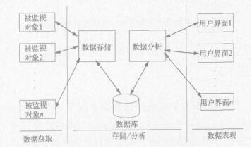
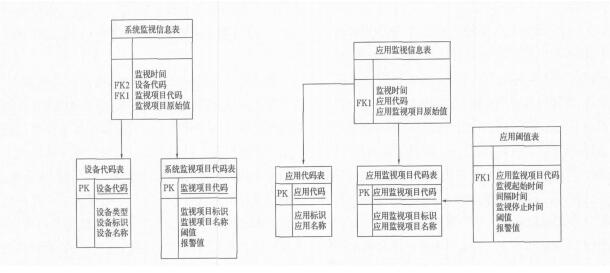
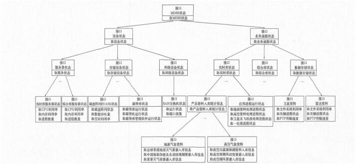
The Design and Implementation of the National Meteorological Data Storage System's Monitor Subsystem
Liu Haoyu, Ma Qiang, Chang Biao, Zhang Xi
2007, 18(2): 251-256.
Abstract:
The purpose of building the monitor subsystem is to guarantee the safe operation of the National Meteorological Data Storage System (MDSS) and to guide the updating of the DMSS. As an infrastructure for sharing scientific meteorological data, real-time operation and post-standardization are supported by MDSS. According to their functions, all components of MDSS are divided into two groups. The supporting equipment includes hardware as well as their accessory software, and the operation of real-time database integrates the database and the data storage. In the equipment group, the targets vital for the smooth running of equipments are monitored, such as the CPU usage and the memory usage of services. Most of the objects monitored in the group of operation are time-series and sequence operation. For instance, the amounts of observed data are entered into the real-time database at a given time. The possibility of using the current monitor software is also considered, and their shortcomings are presented. The structure of the subsystem is divided into three modules:the collection module, the storage and the analysis module and display module. The monitored operation data are gathered repeatedly from the MDSS by the collection module.The gathered information is calculated by the storage and analysis module to confirm the state of the MDSS and the results are stored in the database and the service memory. The state of the MDSS is shown by the display module on the Web pages. A database scheme is designed as the communication channel between the collection module and the storage module. A tree shape program interface is designed for passing information between the modules of storage and display for users on different levels.Some special techniques which are keys for the implementation of the monitor subsystem are explained, such as the Java Stored Procedure. Experience and the following work of the subsystem are also discussed. The reliability and stability are demonstrated by the performance of the subsystem.