
| 试验名称 | 控制试验 (CTRL) | 敏感性试验 | ||
| RADAR-V | RADAR-R | RADAR-VR | ||
| 常规资料 | 有 | 有 | 有 | 有 |
| 雷达径向风 | 无 | 有 | 无 | 有 |
| 雷达反射率因子 | 无 | 无 | 有 | 有 |
| Citation: | Zhang Xinzhong, Chen Junming, Zhao Ping. Impacts of Doppler radar data assimilation on the simulation of severe heavy rainfall events. J Appl Meteor Sci, 2015, 26(5): 555-566. DOI: 10.11898/1001-7313.20150505.

|
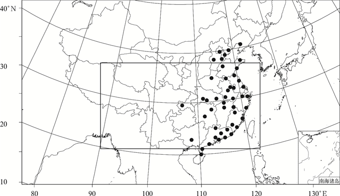
Fig. 1 Mode domain (square frame) and the distribution of radar sites
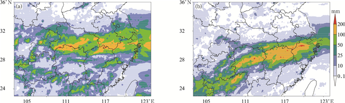
Fig. 2 The observed accumulated precipitation from 0000 UTC 5 Jun to 0000 UTC 8 Jun in 2013(a) and from 0000 UTC 26 Jun to 1200 UTC 28 Jun in 2013(b)
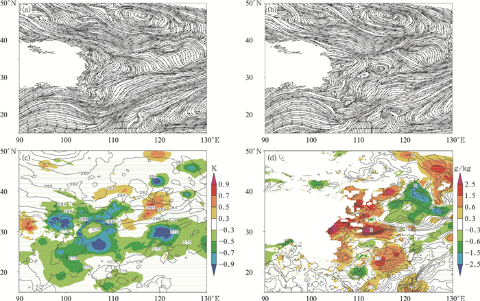
Fig. 3 Variables of background and incremental ground at 0000 UTC 26 Jun in 2013
(a)700 hPa streamlines before assimilating radar data, (b)700 hPa streamlines after assimilating radar data, (c)500 hPa temperature (the contour, unit:K) with the increment (the shaded), (d)850 hPa water vapor mixing ratio (the contour, unit:g/kg) with the increment (the shaded)
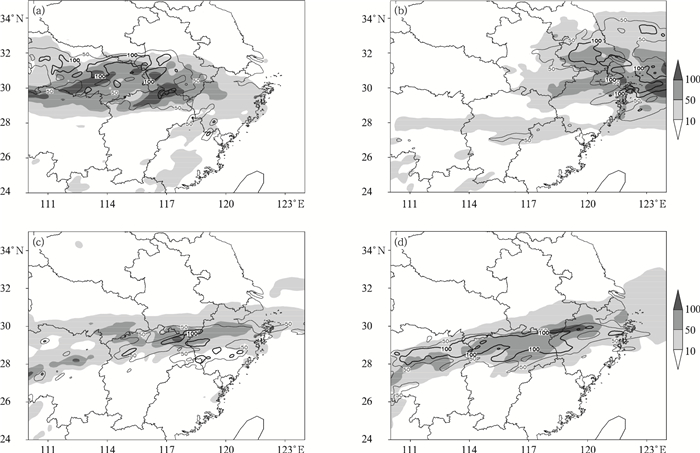
Fig. 4 24 h simulated (the contour) and obseverd (the shaded) accumlated precipitation (unit: mm)
(a) from 0000 UTC 6 Jun to 0000 UTC 7 Jun in 2013, (b) from 0000 UTC 7 Jun to 0000 UTC 8 Jun in 2013, (c) from 0000 UTC 26 Jun to 0000 UTC 27 Jun in 2013, (d) from 0000 UTC 27 Jun to 0000 UTC 28 Jun in 2013
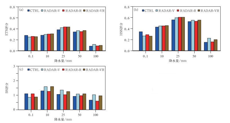
Fig. 5 The verification of 24 h simulated precipitation for case 1
(a) ETS, (b) HSS, (c) BS

Fig. 6 24 h simulated (the contour) and obseverd (the shaded) accumlated precipitation (unit: mm)
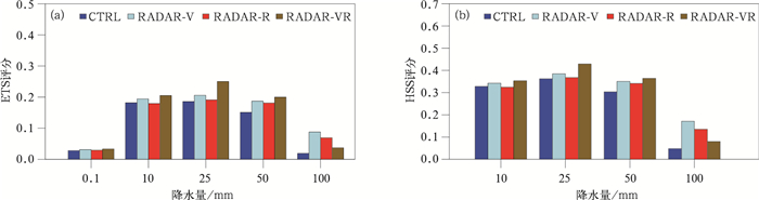
Fig. 7 The verification of 24 h simulated precipitation for case 2
(a) ETS, (b) HSS

Fig. 8 3 h obseverd and simulated accumlated precipitation and the difference between RADVAR-V and CTRL
(a) observation, (b) simulated precipitation, (c) the difference of 850 hPa wind (the vector, unit:m/s) and divergence (the shaded), (d) the difference of precipitation
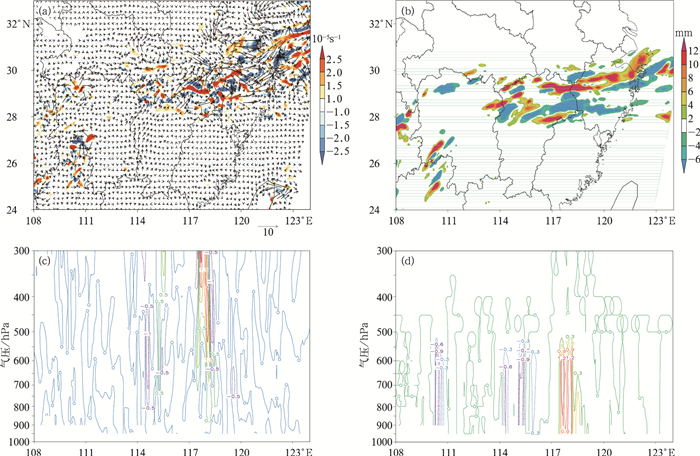
Fig. 9 The difference between RADVAR-R and CTRL
(a)850 hPa wind (the vector, unit:m/s) and divergence (the shaded), (b) precipitation, (c)w(unit:10-1m/s), (d) rain water mixing ratio (unit:g/kg)

Fig. 10 The difference between RADVAR-VR and CTRL
(a)850 hPa wind (the vector, unit:m/s) and divergence (the shaded), (b)w(unit: 10-1m/s), (c) rain water mixing ratio (unit: g/kg), (d) precipitation (the shaded) and 850 hPa w(the contour, unit:10-1m/s)
Table 1 The configuration of experiments
| 试验名称 | 控制试验 (CTRL) | 敏感性试验 | ||
| RADAR-V | RADAR-R | RADAR-VR | ||
| 常规资料 | 有 | 有 | 有 | 有 |
| 雷达径向风 | 无 | 有 | 无 | 有 |
| 雷达反射率因子 | 无 | 无 | 有 | 有 |
 DownLoad: Download CSV
| [1] |
Wolfsberg D.Retrieval of Three Dimensional Wind and Temperature Fields from Single Doppler Radar Data.Oklahoma:University of Oklahoma, 1987:1-91.
|
| [2] |
Sun J, Flicker D, Lilly D.Recovery of three dimensional wind and temperature fields from simulated single Doppler radar data.J Atmos Sci, 1991, 48:876-890. doi: 10.1175/1520-0469(1991)048<0876:ROTDWA>2.0.CO;2
|
| [3] |
Xue M, Wang D, Gao J, et al.The Advanced Regional Prediction System (ARPS), storm-scale numerical weather prediction and data assimilation.Meteor Atmos Phys, 2003, 82(1):139-170. http://www.academia.edu/8561669/The_Advanced_Regional_Prediction_System_ARPS_storm-scale_numerical_weather_prediction_and_data_assimilation
|
| [4] |
Lindskog M, Salonen K, Järvinen H, et al.Doppler radar wind data assimilation with HIRLAM 3DVAR.Mon Wea Rev, 2004, 132:1081-1092. doi: 10.1175/1520-0493(2004)132<1081:DRWDAW>2.0.CO;2
|
| [5] |
Hu M, Xue M, Gao J, et al.3DVAR and cloud analysis with WSR-88D level-Ⅱ data for the prediction of the Fort Worth, Texas, tornadic thunderstorms.Part Ⅱ:Impact of radial velocity analysis via 3DVAR.Mon Wea Rev, 2006, 134(2):699-721. doi: 10.1175/MWR3093.1
|
| [6] |
Xiao Q, Kuo Y H, Sun J, et al.Assimilation of Doppler radar observations with a regional 3DVAR system:Impact of Doppler velocities on forecasts of a heavy rainfall case.J Appl Meteor, 2005, 44:768-788. doi: 10.1175/JAM2248.1
|
| [7] |
马清云, 李泽椿, 陶士伟.单部多普勒天气雷达风场反演及其在数值预报中的应用试验.应用气象学报, 2001, 12(4):488-493. http://qikan.camscma.cn/jams/ch/reader/view_abstract.aspx?file_no=20010463&flag=1
|
| [8] |
万齐林, 薛纪善, 庄世宇.多普勒雷达风场信息变分同化的试验研究.气象学报, 2005, 63(2):129-145. doi: 10.11676/qxxb2005.014
|
| [9] |
张林, 倪允琪.雷达径向风资料的四维变分同化试验.大气科学, 2006, 30(3):433-440. http://www.cnki.com.cn/Article/CJFDTOTAL-DQXK200603006.htm
|
| [10] |
盛春岩, 浦一芬, 高守亭.多普勒天气雷达资料对中尺度模式短时预报的影响.大气科学, 2006, 30(1):93-107. http://www.cnki.com.cn/Article/CJFDTOTAL-DQXK200601007.htm
|
| [11] |
杨毅, 邱崇践, 龚建东, 等.同化多普勒雷达风资料的两种方法比较.高原气象, 2007, 26(3):547-555. http://www.cnki.com.cn/Article/CJFDTOTAL-GYQX200703015.htm
|
| [12] |
闵锦忠, 彭霞云, 赖安伟, 等.反演同化和直接同化多普勒雷达径向风的对比试验.南京气象学院学报, 2007, 30(6):745-754. http://www.cnki.com.cn/Article/CJFDTOTAL-NJQX200706004.htm
|
| [13] |
李柏, 周玉淑, 张沛源.新一代天气雷达资料在2003年江淮流域暴雨模拟中的初步应用:模拟降水和风场的对比.大气科学, 2007, 31(5):826-838. http://www.cnki.com.cn/Article/CJFDTOTAL-DQXK200705006.htm
|
| [14] |
李华宏, 薛纪善, 王曼, 等.多普勒雷达风廓线的反演及变分同化试验.应用气象学报, 2007, 18(1):50-57. doi: 10.11898/1001-7313.20070110
|
| [15] |
杨毅, 邱崇践, 龚建东, 等.三维变分和物理初始化方法相结合同化多普勒雷达资料的试验研究.气象学报, 2008, 66(4):479-488. doi: 10.11676/qxxb2008.045
|
| [16] |
徐广阔, 孙建华, 雷霆, 等.多普勒天气雷达资料同化对暴雨模拟的影响.应用气象学报, 2009, 20(1):36-46. doi: 10.11898/1001-7313.20090105
|
| [17] |
刘红亚, 薛纪善, 顾建峰, 等.三维变分同化雷达资料暴雨个例试验.气象学报, 2010, 68(6):779-789. doi: 10.11676/qxxb2010.074
|
| [18] |
陈敏, 陈明轩, 范水勇.雷达径向风观测在华北区域数值预报系统中的实时三维变分同化应用试验.气象学报, 2014, 72(4):658-677. doi: 10.11676/qxxb2014.070
|
| [19] |
高郁东, 万齐林, 薛纪善, 等.同化雷达估算降水率对暴雨预报的影响.应用气象学报, 2015, 26(1):45-56. http://qikan.camscma.cn/jams/ch/reader/view_abstract.aspx?file_no=20150105&flag=1
|
| [20] |
Shamrock W C, Klemp J B, Dudhia J, et al.A Description of the Advanced Research WRF Version 3.NCAR Tech Note NCAR/TN-475+STR, 2008. https://www.researchgate.net/publication/306154004_A_Description_of_the_Advanced_Research_WRF_Version_3
|
| [21] |
Daryl T K, David F P, John C, et al.Introduction of the GSI into the NCEP global data assimilation system.Wea Forecasting, 2009, 12:1691-1705. https://www.researchgate.net/publication/249612370_Introduction_of_the_GSI_into_the_NCEP_Global_Data_Assimilation_system
|
| [22] |
Saha S, Moorthi S, Pan H L, et al.The NCEP climate forecast system reanalysis.Bull Amer Meteor Soc, 2010, 91(8):1015-1057. doi: 10.1175/2010BAMS3001.1
|
| [23] |
Gao J D, Xue M.A three-dimensional variational data analysis method with recursive filter for Doppler radars.J Atmos Ocean Technol, 2004, 21:457-469. doi: 10.1175/1520-0426(2004)021<0457:ATVDAM>2.0.CO;2
|
| [24] |
Hu M, Xue M.Implementation and evaluation of cloud analysis with WSR-88D reflectivity data for GSI and WRF-ARW.Geophys Res Lett, 2007, 34, L07808, doi: 10.1029/2006GL028847.
|
| [25] |
User's Guide for the Advanced Research WRF (ARW) Modeling System Version 3.5.2014.http://www2.mmm.ucar.edu/wrf/users/docs/user_guide_V3.5/contents.html.
|
| [26] |
王红艳, 刘黎平, 王改利, 等.多普勒天气雷达三维数字组网系统开发及应用.应用气象学报, 2009, 20(2):214-224. doi: 10.11898/1001-7313.20090211
|
| [27] |
王改利, 刘黎平, 阮征.多普勒雷达资料在暴雨临近预报中的应用.应用气象学报, 2007, 18(3):388-395. http://qikan.camscma.cn/jams/ch/reader/view_abstract.aspx?file_no=20070363&flag=1
|
| [28] |
Eilts M D, Smith S D.Efficient dealiasing of Doppler velocities using local environment constraints.J Atmos Ocean Technol, 1990, 7(1):118-128. doi: 10.1175/1520-0426(1990)007<0118:EDODVU>2.0.CO;2
|
| [29] |
Weng Y H, Zhang F Q.Assimilating airborne Doppler radar observations with an Ensemble Kalman Filter for convection-permitting hurricane initialization and prediction:Katrina (2005).Mon Wea Rev, 2012, 140:841-859. doi: 10.1175/2011MWR3602.1
|

Figures(10) / Tables(1)
