Chen Mingxuan, Gao Feng, Sun Juanzhen, et al. An analysis system using rapid-updating 4-D variational radar data assimilation based on VDRAS. J Appl Meteor Sci, 2016, 27(3): 257-272. DOI:  10.11898/1001-7313.20160301.
Citation: Chen Mingxuan, Gao Feng, Sun Juanzhen, et al. An analysis system using rapid-updating 4-D variational radar data assimilation based on VDRAS. J Appl Meteor Sci, 2016, 27(3): 257-272. DOI:  10.11898/1001-7313.20160301.

An Analysis System Using Rapid-updating 4-D Variational Radar Data Assimilation Based on VDRAS

DOI: 10.11898/1001-7313.20160301
  • Received Date: 2015-10-08
  • Rev Recd Date: 2016-02-25
  • Publish Date: 2016-05-31
  • On the basis of further improvement and development of Variational Doppler Radar Analysis System (VDRAS), a rapid-updating 4-D variational analysis system focusing on convective-scale numerical simulation and aiming at nowcasting convective storm has been preliminarily set up and tuned. The system is based on rapid-updating 4-D variational assimilation (RR4DVar) techniques of multi-Doppler-radar observations, a 3-D cloud-scale numerical model with simplified microphysics scheme which includes rainwater evaporation cooling and precipitation sedimentation processes, and an adjoint model. The system can rapidly get low-level 3-D analysis fields including convective-scale dynamical, thermo-dynamical and microphysical structures with 12-18-min updating cycles by assimilating both reflectivity and radial velocity observations from 6 CINRAD Doppler radars in Beijing-Tianjin-Hebei region using the RR4DVar scheme. It also integrates 5-min observations from regional auto weather stations (AWS) and forecast results from a meso-scale numerical model. Allowing for a strong convective storm case occurred in the region on 22 July 2009, simulated results from a series of sensitivity experiments including control, full-troposphere and full-microphysics, meso-scale background, and radar data assimilation are analyzed. These results are also compared and evaluated using intensive local observations from four wind profiler radars, two microwave radiometers, and two boundary layer towers. Some key factors for the system to produce appropriate analysis fields are illuminated. The system using low-level settings with the simplified microphysics scheme has comparable skill with full-troposphere settings and full-microphysics scheme. In the system, most significant RR4DVar assimilation of radar observations can be obtained using two or three scanning volumes from each radar within an assimilation window. As an effective supplement to radar observations on the ground, the AWS data is also very important on the RR4DVar assimilation of radar observations and simulations of dynamical and thermo-dynamical structures at several lower model levels. The meso-scale background and dynamical constraint for the RR4DVar assimilation of radar observations are sensitive to convective-scale simulation in both cold and warm start updating cycles. Results also indicate the system can produce robust pre-storm environment features including low-level inflows, vertical wind shear, low-level small-scale convergence, updraft and warm tongues. On the other hand, storm-associated convective-scale structures including cold pools and outflows can also be reasonably analyzed by the system.
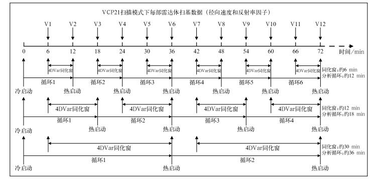
  • Fig. 1  Rapid-refresh cycling processes of the system

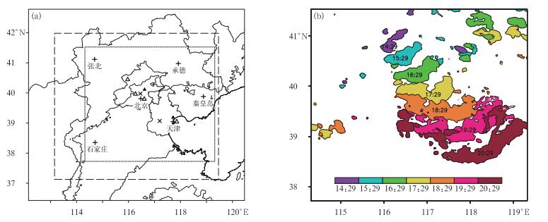
    Fig. 2  Basic system configuration and observational information

    (a) domain of system running (long dash line box), domain of result analysis (short dash line box), and location of observation sites (the plus denotes CINRAD radar site, the open triangle denotes wind profiler, the closed triangle denotes microwave radiometer, the multiplication sign denotes observation tower, thick black line indicates 200 m elevation), (b) patterns and evolution of strong storm echoes at different time on 22 Jul 2009 using mosaic of composite reflectivity no less than 40 dBZ

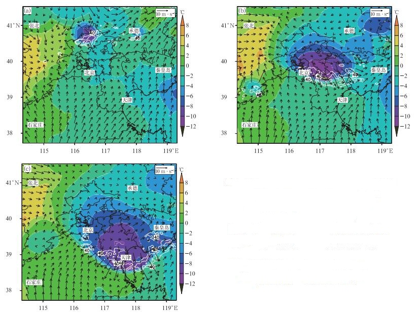
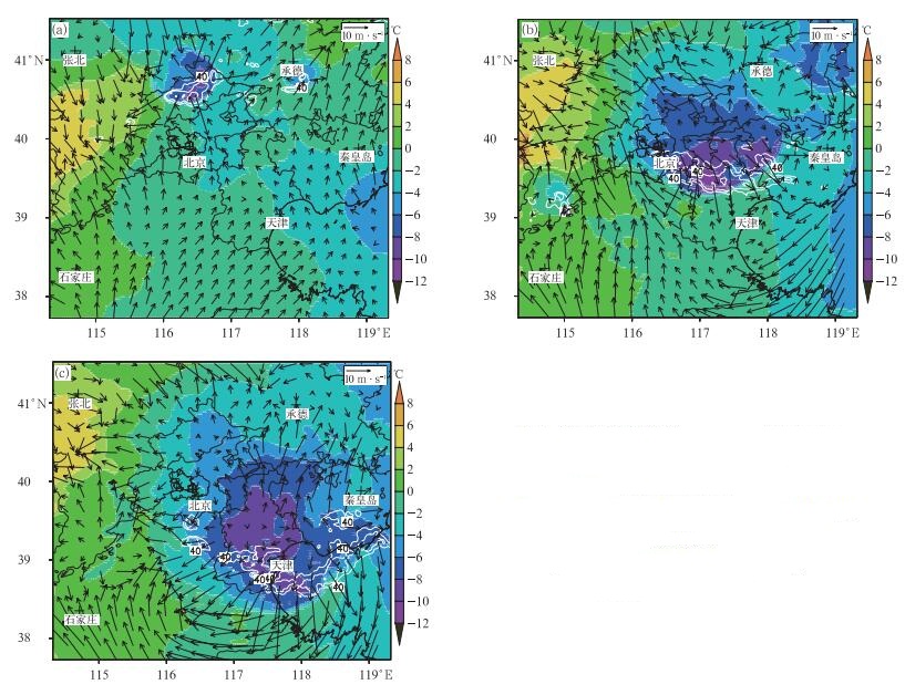
    Fig. 3  Simulated winds (vectors) and perturbation temperature (the shaded) of 187.5 m level at 1529 BT (a), 1829 BT (b) and 2017 BT (c) from EXP_CTRL experiment (white contours indicate observations of radar reflectivity no less than 40 dBZ with 10 dBZ interval)

    Fig. 4  Simulated winds (vectors) and perturbation temperature (the shaded) of 187.5 m level from NO_AWS experiment (others same as in Fig. 3)

    Fig. 5  Simulated winds (vectors) and perturbation temperature (the shaded) of 187.5 m level from WBG_MAWIND0 experiment (others same as in Fig. 3)

    Fig. 6  Simulated winds (vectors) and perturbation temperature (the shaded) of 187.5 m level from NO_CLOSEERADAR2S experiment (others same as in Fig. 3)

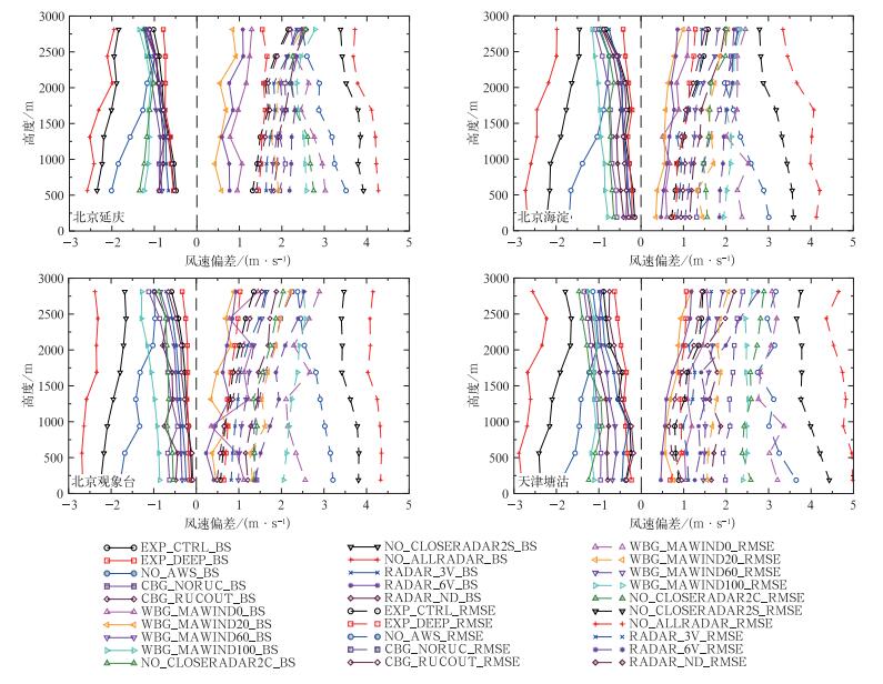
    Fig. 7  Bias (BS, solid lines) and root mean square error (RMSE, dashed lines) of wind speed profiles between results from experiments and observations from wind profiler radars

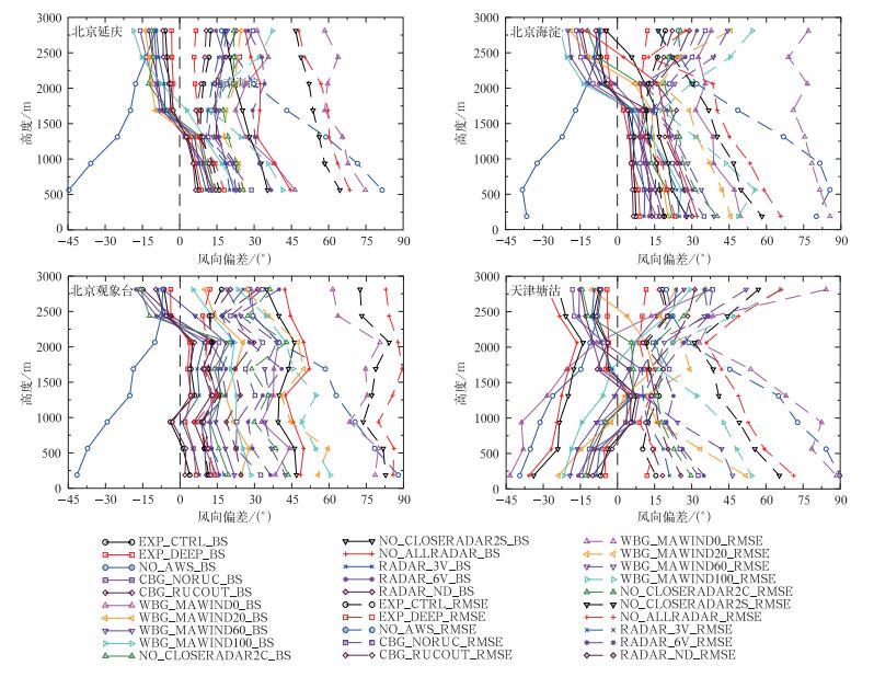
    Fig. 8  Bias (BS, solid lines) and root mean square error (RMSE, dashed lines) of wind direction profiles between results from experiments and observations from wind profiler radars

    Fig. 9  Bias (BS, solid lines) and root mean square error (RMSE, dashed lines) of temperature profiles between results from experiments and observations from microwave radiometers

    Table  1  Configuration of sensitivity experiments

    试验分类 试验名称 试验描述及其与EXP_CTRL试验设置的差异
    控制试验 EXP_CTRL 垂直15层,模式层高5.4375 km;雷达资料同化高度3 km;
    同化窗长度365 s;计算背景场使用25 km间隔BJ-RUC模式探空;
    热启动中尺度背景风场调整权重系数λ=0.4;采用简化Kessler微物理方案
    全对流层试验 EXP_DEEP 垂直40层,模式层高14.8125 km;雷达资料同化高度8.5 km;
    采用完整Kessler微物理方案
    背景场敏感性试验 NO_AWS 冷启动和热启动每个循环均不使用地面AWS资料
    CBG_NORUC 冷启动中尺度背景场计算没有使用BJ-RUC模式资料,仅用雷达
    VAD及14:00北京加密探空和地面AWS资料分析得到
    CBG_RUCOUT 冷启动中尺度背景场使用BJ-RUC模式结果直接插值得到
    WBG_MAWIND0 热启动中尺度背景风场调整权重系数,即热启动每个循环背景风场
    不用中尺度分析风场调整,而使用来自云模式上一循环的6min预报
    WBG_MAWIND20 热启动中尺度背景风场调整权重系数λ=0.2
    WBG_MAWIND60 热启动中尺度背景风场调整权重系数λ=0.6
    WBG_MAWIND100 热启动中尺度背景风场调整权重系数λ=1,即热启动每个循环的
    背景风场全部用中尺度分析风场替代
    雷达资料同化敏感性试验 NO_CLOSERADAR2C 不同化离风暴最接近的两部C波段雷达 (张北和承德) 的资料
    NO_CLOSERADAR2S 不同化离风暴最接近的两部S波段雷达 (北京和天津) 的资料
    NO_ALLRADAR 不同化所有6部雷达的资料,只用中尺度分析场
    RADAR_3V 同化窗长度为730 s
    RADAR_6V 同化窗长度为1830 s
    DownLoad: Download CSV
  • [1]
    陈明轩, 俞小鼎, 谭晓光, 等.对流天气临近预报技术的发展与研究进展.应用气象学报, 2004, 15(6):754-766. http://qikan.camscma.cn/jams/ch/reader/view_abstract.aspx?file_no=20040693&flag=1
    [2]
    俞小鼎, 周小刚, 王秀明.雷暴与强对流临近天气预报技术进展.气象学报, 2012, 70(3):311-337. doi:  10.11676/qxxb2012.030
    [3]
    郑永光, 周康辉, 盛杰, 等.强对流天气监测预报预警技术进展.应用气象学报, 2015, 26(6):641-657. doi:  10.11898/1001-7313.20150601
    [4]
    Wilson J W, Feng Y, Chen M, et al.Nowcasting challenges during the Beijing Olympics:Successes, failures, and implications for future nowcasting systems.Wea Forecasting, 2010, 25:1691-1714. doi:  10.1175/2010WAF2222417.1
    [5]
    Houze R A Jr, Smull B F, Dodge P.Mesoscale organization of springtime rainstorms in Oklahoma.Mon Wea Rev, 1990, 118:613-654. doi:  10.1175/1520-0493(1990)118<0613:MOOSRI>2.0.CO;2
    [6]
    Weisman M L, Rotunno R.The use of vertical wind shear versus helicity in interpreting supercell dynamics.J Atmos Sci, 2000, 57:1452-1472. doi:  10.1175/1520-0469(2000)057<1452:TUOVWS>2.0.CO;2
    [7]
    Droegemeier K K, Wilhelmson R B.Numerical simulation of thunderstorm outflow dynamics.Part Ⅰ:Outflow sensitivity experiments and turbulence dynamics.J Atmos Sci, 1987, 44:1180-1210. doi:  10.1175/1520-0469(1987)044<1180:NSOTOD>2.0.CO;2
    [8]
    Mueller C K, Carbone R E.Dynamics of a thunderstorm outflow.J Atmos Sci, 1987, 44:1879-1898. doi:  10.1175/1520-0469(1987)044<1879:DOATO>2.0.CO;2
    [9]
    Rotunno R, Klemp J B, Weisman M L.A theory for strong, long-lived squall lines.J Atmos Sci, 1988, 45:463-485. doi:  10.1175/1520-0469(1988)045<0463:ATFSLL>2.0.CO;2
    [10]
    Coniglio M C, Corfidi S F, Kain J S.Views on applying RKW theory:An illustration using the 8 May 2009 derecho-producing convective system.Mon Wea Rev, 2012, 140:1023-1043. doi:  10.1175/MWR-D-11-00026.1
    [11]
    陈明轩, 王迎春.低层垂直风切变和冷池相互作用影响华北地区一次飑线过程发展维持的数值模拟.气象学报, 2012, 70(3):371-386. doi:  10.11676/qxxb2012.033
    [12]
    Wilson J W, Megenhardt D L.Thunderstorm initiation, organization and lifetime associated with Florida boundary layer convergence lines.Mon Wea Rev, 1997, 125:1507-1525. doi:  10.1175/1520-0493(1997)125<1507:TIOALA>2.0.CO;2
    [13]
    陈明轩, 高峰, 孔荣, 等.自动临近预报系统及其在北京奥运期间的应用.应用气象学报, 2010, 21(4):395-404. doi:  10.11898/1001-7313.20100402
    [14]
    王彦, 于莉莉, 李艳伟, 等.边界层辐合线对强对流系统形成和发展的作用.应用气象学报, 2011, 22(6):724-731. doi:  10.11898/1001-7313.20110610
    [15]
    Sun J, Xue M, Wilson J.Use of NWP for nowcasting convective precipitation:Recent progress and chuenges.Bull Amer Meteor Soc, 2014, 95:409-426. doi:  10.1175/BAMS-D-11-00263.1
    [16]
    Sun J, Crook N A.Dynamical and microphysical retrieval from Doppler radar observations using a cloud model and its adjoint:Ⅰ.model development and simulated data experiments.J Atmos Sci, 1997, 54:1642-1661. doi:  10.1175/1520-0469(1997)054<1642:DAMRFD>2.0.CO;2
    [17]
    Sun J, Crook N A.Dynamical and microphysical retrieval from Doppler radar observations using a cloud model and its adjoint:Ⅱ.Retrieval experiments of an observed Florida convective storm.J Atmos Sci, 1998, 55:835-852. doi:  10.1175/1520-0469(1998)055<0835:DAMRFD>2.0.CO;2
    [18]
    Sun J, Crook N A.Real-time low-level wind and temperature analysis using single WSR-88D data.Wea Forecasting, 2001, 16:117-132. doi:  10.1175/1520-0434(2001)016<0117:RTLLWA>2.0.CO;2
    [19]
    Crook N A, Sun J.Analysis and forecasting of the low-level wind during the Sydney 2000 Forecast Demonstration Project.Wea Forecasting, 2004, 19:151-167. doi:  10.1175/1520-0434(2004)019<0151:AAFOTL>2.0.CO;2
    [20]
    Chen M X, Sun J, Wang Y C.A Frequent-updating High-resolution Analysis System Based on Radar Data for the 2008 Summer Olympics.Preprint.The 33rd International Conference on Radar Meteorology, Cairns, Australia, 2007. https://ams.confex.com/ams/33Radar/webprogram/Paper123091.html
    [21]
    Sun J, Zhang Y.Analysis and prediction of a squall line observed during IHOP using multiple WSR-88D observations.Mon Wea Rev, 2008, 136:2364-2388. doi:  10.1175/2007MWR2205.1
    [22]
    Sun J, Chen M X, Wang Y C.A frequent-updating analysis system based on radar, surface, and mesoscale model data for the Beijing 2008 Forecast Demonstration Project.Wea Forecasting, 2010, 25:1715-1735. doi:  10.1175/2010WAF2222336.1
    [23]
    陈明轩, 王迎春, 高峰, 等.基于雷达资料4DVar的低层热动力反演系统及其在北京奥运期间的初步应用分析.气象学报, 2011, 69(1):64-78. doi:  10.11676/qxxb2011.006
    [24]
    陈明轩, 王迎春, 肖现, 等.基于雷达资料四维变分同化和三维云模式对一次超级单体风暴发展维持热动力机制的模拟分析.大气科学, 2012, 36(5):929-944. doi:  10.3878/j.issn.1006-9895.2012.11132
    [25]
    陈明轩, 王迎春, 肖现, 等.北京"7.21"暴雨雨团的发生和传播机理.气象学报, 2013, 71(4):569-592. doi:  10.11676/qxxb2013.053
    [26]
    孙继松, 何娜, 郭锐, 等.多单体雷暴的形变与列车效应传播机制.大气科学, 2013, 37(1):137-148. doi:  10.3878/j.issn.1006-9895.2012.12015
    [27]
    肖现, 王迎春, 陈明轩, 等.基于雷达资料四维变分同化技术对北京地区一次下山突发性增强风暴热动力机制的模拟分析.气象学报, 2013, 71(5):797-816. doi:  10.11676/qxxb2013.077
    [28]
    肖现, 陈明轩, 高峰, 等.弱天气系统强迫下北京地区对流下山演变的热动力机制.大气科学, 2015, 39(1):100-124. doi:  10.3878/j.issn.1006-9895.1403.13318
    [29]
    Sun J.Convective-scale assimilation of radar data:Progress and challenges.Q J R Meteor Soc, 2005, 131:3439-3463. doi:  10.1256/qj.05.149
    [30]
    Lim E, Sun J.A velocity dealiasing technique using rapidly updated analysis from a four-dimensional variational doppler radar data assimilation system.J Atmos Oceanic Technol, 2010, 27:1140-1152. doi:  10.1175/2010JTECHA1300.1
    [31]
    Hayden C M, Purser R J.Recursive filter objective analysis of meteorological fields:Applications to NESDIS operational processing.J Appl Meteor, 1995, 34:3-15. doi:  10.1175/1520-0450-34.1.3
    [32]
    陈敏, 范水勇, 郑祚芳, 等.基于BJ-RUC系统的临近探空及其对强对流发生潜势预报的指示性能初探.气象学报, 2011, 69(1):181-194. doi:  10.11676/qxxb2011.016
    [33]
    刘梦娟, 陈敏.BJ-RUC系统对北京夏季边界层的预报性能评估.应用气象学报, 2014, 25(2):212-221. doi:  10.11898/1001-7313.20140211
    [34]
    Chen M X, Wang Y C, Gao F, et al.Diurnal variations in convective storm activity over contiguous North China during the warm-season based on radar mosaic climatology.J Geophys Res, 2012, 117, D20115, doi: 10.1029/2012JD018158.
    [35]
    Chen M X, Wang Y C, Gao F, et al.Diurnal evolution and distribution of warm-season convective storms in different prevailing wind regimes over contiguous North China.J Geophys Res Atmos, 2014, 119:2742-2763, doi: 10.1002/2013JD021145.
    [36]
    邓闯, 阮征, 魏鸣, 等.风廓线雷达测风精度评估.应用气象学报, 2012, 23(5):523-533. doi:  10.11898/1001-7313.20120502
  • 加载中
  • -->

Catalog

    Figures(9)  / Tables(1)

    Article views (3677) PDF downloads(556) Cited by()
    • Received : 2015-10-08
    • Accepted : 2016-02-25
    • Published : 2016-05-31

    /

    DownLoad:  Full-Size Img  PowerPoint