| Citation: | Cheng Zhengquan, Lin Liangxun, Yang Guojie, et al. Rapid intensification and associated large-scale circulation of super typhoon Rammasun in 2014. J Appl Meteor Sci, 2017, 28(3): 318-326. DOI: 10.11898/1001-7313.20170306.

|
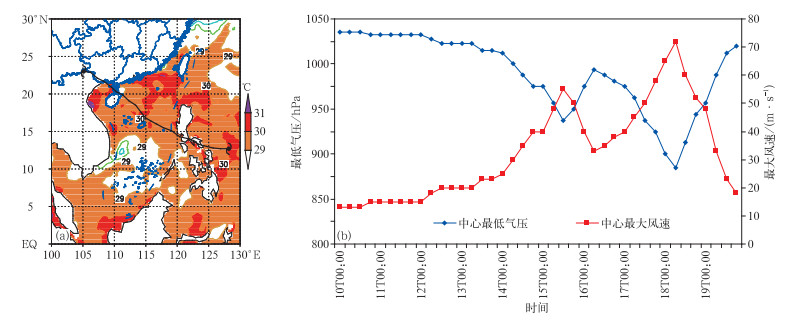
Fig. 1 The track and the maximal sea surface temperature during 15-19 Jul 2014(a) and the central maximal wind speed with minimal pressure (b) of Rammasum in 2014
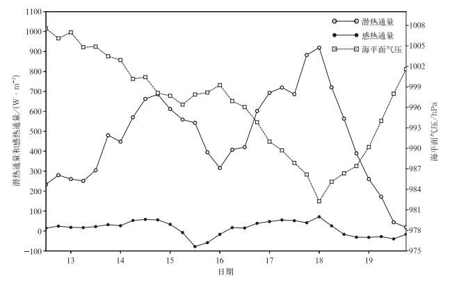
Fig. 2 Area-averaged sea level pressure, sea surface latent flux and sensible heat flux within a domain of 3°×3° where Rammasum locates in the center from 13 Jul to 19 Jul in 2014
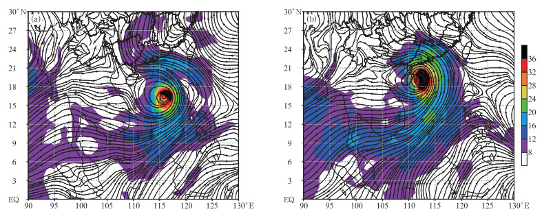
Fig. 3 850 hPa flow field the (the vector) and water vapor flux (the shaded, unit:g·s-1·hPa-1·cm-1)
(a)0000 UTC 17 Jul 2014, (b)0000 UTC 18 Jul 2014
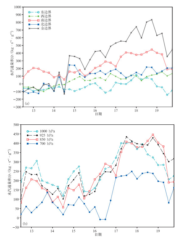
Fig. 4 850 hPa water vapor integration for boundaries (a) and horizontal water vapor integration for southern boundary (b) from 13 Jul to 19 Jul in 2014
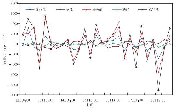
Fig. 5 6 h differences for 850 hPa total energy and each item from 12 Jul to 18 Jul in 2014
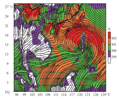
Fig. 6 925 hPa potential pseudo-equivalent temperature (the shaded) and winds (the vector) at 0000 UTC 16 Jul 2014
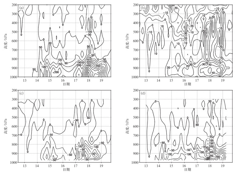
Fig. 7 Area-averaged each item of kinetic energy budget from 13 Jul to 19 Jul in 2014(unit:10-4m2·s-3)
(a) kinetic energy production term, (b) divergent term of horizontal kinetic energy flux, (c) divergent term of vertical kinetic energy flux, (d) dissipative term
| [1] |
冯锦全, 陈多.我国近海热带气旋强度突变的气候特征分析.热带气象学报, 1995, 11(1):35-42. http://www.cnki.com.cn/Article/CJFDTOTAL-RDQX199501004.htm
|
| [2] |
麻素红, 吴俞, 瞿安详, 等.T213与T639模式热带气旋预报误差对比.应用气象学报, 2012, 23(2):167-173. doi: 10.11898/1001-7313.20120205
|
| [3] |
何夏江, 曾琮.热带气旋路径强度预报——SAPC法.应用气象学报, 1996, 7(1):45-52. http://qikan.camscma.cn/jams/ch/reader/view_abstract.aspx?file_no=19960106&flag=1
|
| [4] |
许映龙, 张玲, 高拴柱.我国台风预报业务的现状及思考.气象, 2010, 36(7):43-49. doi: 10.7519/j.issn.1000-0526.2010.07.009
|
| [5] |
漆梁波, 黄丹青, 余晖.1999-2003年西北太平洋热带气旋综合预报的误差分析.应用气象学报, 2006, 17(1):73-80. doi: 10.11898/1001-7313.20060113
|
| [6] |
林良勋, 梁巧倩, 黄忠.华南近海急剧加强热带气旋极其环流综合分析.气象, 2006, 32(2):14-18. doi: 10.7519/j.issn.1000-0526.2006.02.003
|
| [7] |
陈联寿.热带气旋研究和业务预报技术的发展.应用气象学报, 2006, 17(6):672-681. doi: 10.11898/1001-7313.20060605
|
| [8] |
Alexander L, Michael L B.Structural and intensity changes of Hurricane Bret (1999).PartⅠ:Environmental influences.Mon Wea Rev, 2008, 136:4320-4333.
|
| [9] |
Holliday C R, Thompson A H.Climatological characteristics of rapidly intensifying typhoon.Mon Wea Rev, 1979, 107:1022-1034. doi: 10.1175/1520-0493(1979)107<1022:CCORIT>2.0.CO;2
|
| [10] |
于玉斌.我国近海热带气旋强度突变的机理研究.北京:中国气象科学研究院, 2007.
|
| [11] |
陈联寿, 丁一汇.西太平洋台风概论.北京:科学出版社, 1979.
|
| [12] |
Gallina G M, Velden C S.Environmental Vertical Wind Shear and Tropical Cyclone Intensity Change Utilizing Enhanced Satellite Derived Wind Information.Extended Abstracts, 25th Conf on Hurricanes and Tropical Meteorology, Amer Meteor Soc, 2002.
|
| [13] |
于玉斌, 杨昌贤, 姚秀萍.近海热带气旋强度突变的垂直结构特征分析.大气科学, 2007, 31(5):876-882. http://www.cnki.com.cn/Article/CJFDTOTAL-DQXK200705010.htm
|
| [14] |
徐明, 余锦华, 赖安伟, 等.环境风垂直切变与登陆台风强度变化关系的统计分析.暴雨灾害, 2009(4):339-344. http://www.cnki.com.cn/Article/CJFDTOTAL-HBQX200904009.htm
|
| [15] |
张玲. 加强集合预报订正和卫星资料分析对改进2012年疑难台风预报的思考. 第九届全国灾害性天气预报技术研讨会, 2012.
|
| [16] |
范蕙君, 李修芳.用数字云图确定热带气旋强度方法的检验和应用.应用气象学报, 1996, 7(1):113-117. http://qikan.camscma.cn/jams/ch/reader/view_abstract.aspx?file_no=19960116&flag=1
|
| [17] |
王瑾, 江吉喜.热带气旋强度的卫星探测客观估计方法研究.应用气象学报, 2005, 16(3):283-292. doi: 10.11898/1001-7313.20050302
|
| [18] |
鲁小琴, 雷小途, 余晖, 等.基于卫星资料进行热带气旋强度客观估算.应用气象学报, 2014, 25(1):52-58. doi: 10.11898/1001-7313.20140106
|
| [19] |
阎俊岳.近海热带气旋迅速加强的气候特征.应用气象学报, 1996, 7(1):28-35. http://qikan.camscma.cn/jams/ch/reader/view_abstract.aspx?file_no=19960104&flag=1
|
| [20] |
Ying M, Zhang W, Yu H, et al.An overview of the China Meteorological Administration tropical cyclone database.J Atmos Oceanic Technol, 2014, 31:287-301. doi: 10.1175/JTECH-D-12-00119.1
|
| [21] |
丁一汇.天气动力学中的诊断分析方法.北京:科学出版社, 1989.
|
| [22] |
林良勋.广东省天气预报技术手册.北京:气象出版社, 2006.
|
| [23] |
朱乾根, 林瑞锦, 寿绍文, 等.天气学原理和方法.北京:气象出版社, 2009.
|
| [24] |
吕心艳, 高拴柱, 董林.近海台风快速增强的环境风垂直切变统计特征.天气预报, 2016(1):52-57. http://cdmd.cnki.com.cn/Article/CDMD-85101-1015305948.htm
|
| [25] |
钮学新, 杜惠良, 刘建勇, 等.0216号台风降水及其影响降水机制的数值模拟试验.气象学报, 2005, 63(1):57-68. doi: 10.11676/qxxb2005.007
|
| [26] |
程正泉, 陈联寿, 李英.登陆台风降水的大尺度环流诊断分析.气象学报, 2009, 67(5):840-850. doi: 10.11676/qxxb2009.082
|
| [27] |
于玉斌, 姚秀萍.中国近海热带气旋强度突变的热力特征.气象学报, 2010, 68(1):48-58. doi: 10.11676/qxxb2010.006
|
| [28] |
吕美仲, 侯志明, 周毅.动力气象学.北京:气象出版社, 2004.
|

Figures(7)


 DownLoad: