| 统计量 | 白天 | 夜间 |
| 偏差/℃ | 0.01 | 0.05 |
| 绝对偏差/℃ | 0.5 | 0.53 |
| 标准差/℃ | 0.61 | 0.66 |
| 样本量 | 7381 | 7803 |
| Citation: | Cui Peng, Wang Sujuan, Lu Feng, et al. FY-4A/AGRI sea surface temperature product and quality validation. J Appl Meteor Sci, 2023, 34(3): 257-269. DOI: 10.11898/1001-7313.20230301.

|

Fig. 1 Histogram of difference between FY-4A/AGRI SST and buoy SST from Jul 2021 to Jun 2022
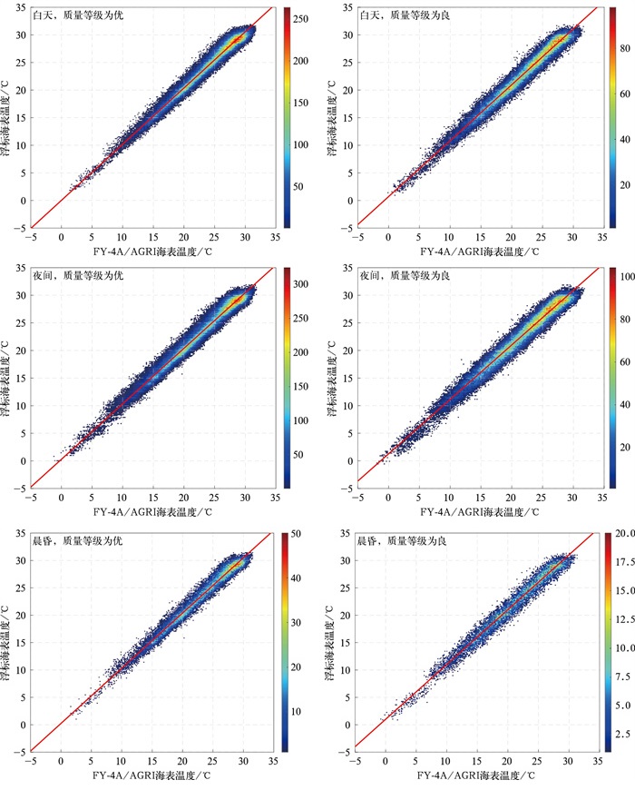
Fig. 2 Scatter density map of FY-4A/AGRI SST and buoy SST from Jul 2021 to Jun 2022
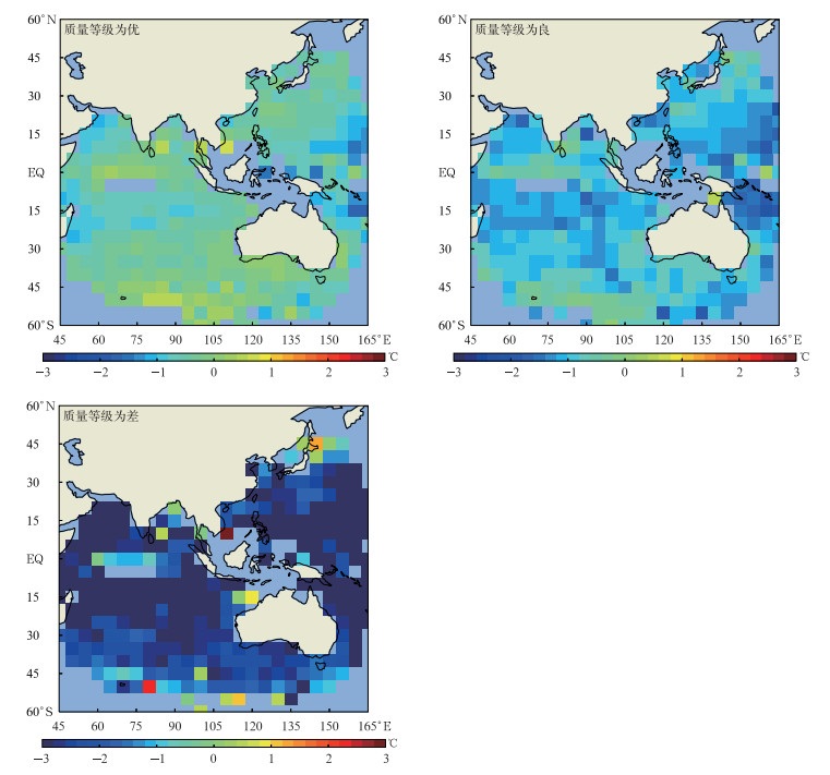
Fig. 3 Biases in 5°×5° square of FY-4A/AGRI SST against buoy SST from Jul 2021 to Jun 2022

Fig. 4 Time series of bias and standard deviation of FY-4A/AGRI SST relative to buoy SST from Jul 2021 to Jun 2022
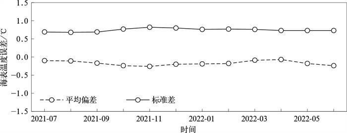
Fig. 5 Time series of bias and standard deviation of excellent quality FY-4A/AGRI SST relative to Himawari-8/AHI SST from Jul 2021 to Jun 2022
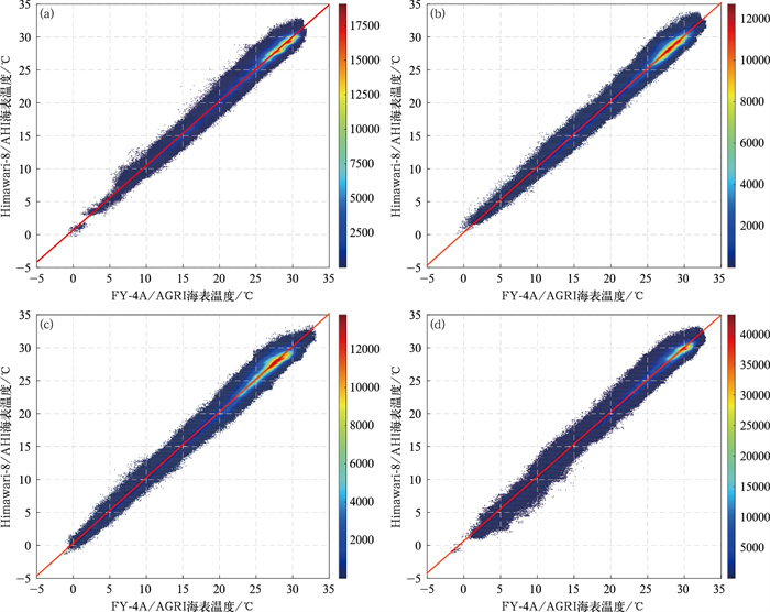
Fig. 6 Scatter density map of FY-4A/AGRI SST and Himawari-8/AHI SST
(a)1 Jul, 1 Aug and 1 Sep in 2021, (b)1 Oct, 1 Nov and 1 Dec in 2021, (c)1 Jan, 1 Feb and 1 Mar in 2022, (d)1 Apr, 1 May and 1 Jun in 2022
Table 1 SST deviation of FY-4A/AGRI NLSST algorithm
| 统计量 | 白天 | 夜间 |
| 偏差/℃ | 0.01 | 0.05 |
| 绝对偏差/℃ | 0.5 | 0.53 |
| 标准差/℃ | 0.61 | 0.66 |
| 样本量 | 7381 | 7803 |
 DownLoad: Download CSV
Table 2 Error information of FY-4A/AGRI SST relative to buoy SST
| 时段 | 统计量 | 优 | 良 | 差 |
| 白天 | 平均偏差/℃ | -0.45 | -1.00 | -2.25 |
| 标准差/℃ | 0.81 | 0.94 | 1.94 | |
| 样本量 | 171473 | 81570 | 35607 | |
| 夜间 | 平均偏差/℃ | -0.42 | -0.99 | -2.94 |
| 标准差/℃ | 0.88 | 1.03 | 1.99 | |
| 样本量 | 199364 | 92084 | 76844 | |
| 晨昏 | 平均偏差/℃ | -0.42 | -1.02 | -2.80 |
| 标准差/℃ | 0.85 | 0.99 | 1.97 | |
| 样本量 | 28501 | 12386 | 8598 |
DownLoad: Download CSV
| [1] |
Ignatov A.GOES-R Advanced Baseline Imager(ABI) Algorithm Theoretical Basis Document for Sea Surface Temperature.[2022-11-29].
|
| [2] |
Donlon C, Martin M, Stark J, et al. The operational sea surface temperature and sea ice analysis(OSTIA) system. Remote Sens Environ, 2012, 116: 140-158. doi: 10.1016/j.rse.2010.10.017
|
| [3] |
Ke Z J, Hua L J, Zhong L H, et al. The influence of sea surface temperature anomaly on the East Asian summer monsoon strength and its precursor. J Appl Meteor Sci, 2015, 26(5): 536-544. doi: 10.11898/1001-7313.20150503
|
| [4] |
Brasnett B. The impact of satellite retrievals in a global sea-surface-temperature analysis. Quart J Roy Meteor Soc, 2008, 134(636): 1745-1760. doi: 10.1002/qj.319
|
| [5] |
Wang S J, Cui P, Zhang P, et al. FY-3C/VIRR sea surface temperature products and quality validation. J Appl Meteor Sci, 2020, 31(6): 729-739. doi: 10.11898/1001-7313.20200608
|
| [6] |
Cayula J F P, May D A, McKenzie B D, et al. VⅡRS-derived SST at the naval oceanographic office: From evaluation to operation. Proc SPIE. 2013, 8724: 87240S. doi: 10.1117/12.2017965
|
| [7] |
Brasnett B, Colan D S. Assimilating retrievals of sea surface temperature from VⅡRS and AMSR2. J Atmos Ocean Technol, 2016, 33(2): 361-375. doi: 10.1175/JTECH-D-15-0093.1
|
| [8] |
Maturi E, Harris A, Mittaz J, et al. A new high-resolution sea surface temperature blended analysis. Bull Amer Meteor Soc, 2017, 98(5): 1015-1026. doi: 10.1175/BAMS-D-15-00002.1
|
| [9] |
Le Borgne P, Legendre G, Marsouin A. Operational SST Retrieval from MSG/SEVIRI Data. The 2006 EUMETSAT Meteorological Satellite Conference, 2006.
|
| [10] |
Schmit T J, Gunshor M M, Menzel W P, et al. Introducing the next-generation Advanced Baseline Imager on GOES-R. Bull Amer Meteor Soc, 2005, 86(8): 1079-1096. doi: 10.1175/BAMS-86-8-1079
|
| [11] |
Anding D, Kauth R. Estimation of sea surface temperature from space. Remote Sens Environ, 1970, 1(4): 217-220. doi: 10.1016/S0034-4257(70)80002-5
|
| [12] |
Prabhakara C, Dalu G, Kunde V G. Estimation of sea surface temperature from remote sensing in the 11- to 13-μm window region. J Geophys Res, 1974, 79(33): 5039-5044. doi: 10.1029/JC079i033p05039
|
| [13] |
OSISAF. Geostationary Sea Surface Temperature Product User Manual. EUMETSAT, Berlin, 2011.
|
| [14] |
Kilpatrick K A, Podestá G P, Evans R. Overview of the NOAA/NASA advanced very high resolution radiometer Pathfinder algorithm for sea surface temperature and associated matchup database. J Geophys Res, 2001, 106(C5): 9179-9197. doi: 10.1029/1999JC000065
|
| [15] |
Casey K S, Brandon T B, Cornillon P, et al. The Past, Present, and Future of the AVHRR Pathfinder SST Program. Springer Netherlands, 2010: 273-287.
|
| [16] |
Petrenko B, Ignatov A, Kihai Y, et al. Clear-sky mask for the advanced clear-sky processor for oceans. J Atmos Ocean Technol, 2010, 27(10): 1609-1623. doi: 10.1175/2010JTECHA1413.1
|
| [17] |
Saha K, Ignatov A, Liang X M, et al. Selecting a first-guess SST as input to ACSPO. Proc SPIE, 2012, 8372: 83720L. doi: 10.1117/12.918093
|
| [18] |
Gao Y, Cai M, Cao Z Q, et al. Environmental conditions and cloud macro and micro features of "21·7" extreme heavy rainfall in Henan Province. J Appl Meteor Sci, 2022, 33(6): 682-695. doi: 10.11898/1001-7313.20220604
|
| [19] |
Ren S L, Niu N, Qin D Y, et al. Extreme cold and snowstorm event in North America in February 2021 based on satellite data. J Appl Meteor Sci, 2022, 33(6): 696-710. doi: 10.11898/1001-7313.20220605
|
| [20] |
Zhang Z Q, Lu F, Fang X, et al. Application and development of FY-4 meteorological satellite. Aerospace Shanghai, 2017, 34(4): 8-12. https://www.cnki.com.cn/Article/CJFDTOTAL-SHHT201704002.htm
|
| [21] |
Yang J, Zhang Z Q, Wei C Y, et al. Introducing the new generation of Chinese geostationary weather satellites, Fengyun-4. Bull Amer Meteor Soc, 2017, 98(8): 1637-1658. doi: 10.1175/BAMS-D-16-0065.1
|
| [22] |
Lu F, Zhang X H, Chen B Y, et al. FY-4 geostationary meteorological satellite imaging characteristics and its application prospects. J Mar Meteor, 2017, 37(2): 1-12. https://www.cnki.com.cn/Article/CJFDTOTAL-SDQX201702001.htm
|
| [23] |
Wang X, Min M, Wang F. Intercomparisons of cloud mask products among Fengyun-4A, Himawari-8, and MODIS. IEEE Trans Geosci Remote Sens, 2019, 57(11): 8827-8839. doi: 10.1109/TGRS.2019.2923247
|
| [24] |
Xu F, Ignatov A. In situ SST quality monitor(iQuam). J Atmos Ocean Technol, 2014, 31(1): 164-180. doi: 10.1175/JTECH-D-13-00121.1
|
| [25] |
Kurihara Y, Murakami H, Kachi M. Sea surface temperature from the new Japanese geostationary meteorological Himawari-8 satellite. Geophys Res Lett, 2016, 43(3): 1234-1240. doi: 10.1002/2015GL067159
|
| [26] |
Kramar M, Ignatov A, Petrenko B, et al. Near real time SST retrievals from Himawari-8 at NOAA using ACSPO system. Proc SPIE, 2016, 9827: 98270L.
|
| [27] |
McClain E P, Pichel W G, Walton C C. Comparative performance of AVHRR-based multichannel sea surface temperatures. J Geophys Res Oceans, 1985, 90(6): 11587-11601.
|
| [28] |
Walton C C. Nonlinear multichannel algorithms for estimating sea surface temperature with AVHRR satellite data. J Appl Meteorol, 1988, 27(2): 115-124. doi: 10.1175/1520-0450(1988)027<0115:NMAFES>2.0.CO;2
|
| [29] |
Wang S J, Cui P, Zhang P, et al. The improvement of FY-3B/VIRR SST algorithm and its accuracy. J Appl Meteor Sci, 2014, 25(6): 701-710. http://qikan.camscma.cn/article/id/20140606
|
| [30] |
Wei C Y, Zhang X H, Zhao X G, et al. FY-2 meteorological satellite attitude solving method under area scan mode. J Appl Meteor Sci, 2014, 25(5): 592-599. http://qikan.camscma.cn/article/id/20140508
|
| [31] |
Wang S J, Guo Q, Xu J M. Guide star sub catalog method for FY-4 meteorological satellite. J Appl Meteor Sci, 2010, 21(2): 149-156. http://qikan.camscma.cn/article/id/20100203
|
| [32] |
Lu F, Xu J M, Zhang Q S. Impact study of attitude and pitch misalignment parameters on FY-2 image navigation with simulation method. J Appl Meteor Sci, 2001, 12(4): 393-399. http://qikan.camscma.cn/article/id/20010454
|
| [33] |
Gu S Y, Qiu H, Fan T X. Inter-calibration between FY-2A IR channel and GMS-5 IRA channel. J Appl Meteor Sci, 2001, 12(1): 79-84. http://qikan.camscma.cn/article/id/20010109
|
| [34] |
Yang Z D, Liu J. A review of visible infrared imaging radiometer on meteorological satellite. J Appl Meteor Sci, 2016, 27(5): 592-603. doi: 10.11898/1001-7313.20160508
|
| [35] |
Zhou X S, Guo Q Y, Xia Y C, et al. Inspection of FY-3D satellite temperature data based on horizontal drift round-trip sounding data. J Appl Meteor Sci, 2023, 34(1): 52-64. doi: 10.11898/1001-7313.20230105
|
| [36] |
Liu J, Cui P, Xiao M. The bias analysis of FY-2G cloud fraction in summer and winter. J Appl Meteor Sci, 2017, 28(2): 177-188. doi: 10.11898/1001-7313.20170205
|

Figures(6) / Tables(2)
