Guo Feiyan, Diao Xiuguang, Chu Yingjia, et al. Dual polarization radar characteristics of severe downburst occurred in weak vertical wind shear. J Appl Meteor Sci, 2023, 34(6): 681-693. DOI:  10.11898/1001-7313.20230604.
Citation: Guo Feiyan, Diao Xiuguang, Chu Yingjia, et al. Dual polarization radar characteristics of severe downburst occurred in weak vertical wind shear. J Appl Meteor Sci, 2023, 34(6): 681-693. DOI:  10.11898/1001-7313.20230604.

Dual Polarization Radar Characteristics of Severe Downburst Occurred in Weak Vertical Wind Shear

DOI: 10.11898/1001-7313.20230604
  • Received Date: 2023-05-04
  • Rev Recd Date: 2023-08-02
  • Publish Date: 2023-11-27
  • Based on S-band Dual polarization doppler radar data and conventional observations, characteristics of 3 severe downbursts occurred under the background of weak vertical wind shear are analyzed, and their possible physical formation mechanisms are studied. It shows that they all occur with high convective available potential energy, but the vertical wind shear (less than 10 m·s-1) of the environmental atmosphere is weak. 6·30 storm and 7·2 storm are featured by wetter air at low level and drier air at middle (or high) level, while the atmosphere air for 6·26 storm is dry from low level to high level except for the near surface layer. With weak wind vertical shear and higher 0℃ layer height, this type of severe downburst is mostly along with high intensity precipitation (over 3 mm per minute). Before the severe downbursts touch down, the storms grow intensively (over 60 dBZ) and expand over 10 km height, the differential reflectivity (ZDR) and specific differential phase shift (KDP) columns are higher over -10℃ layer, and KDP columns' area at -10℃ layer are larger than ZDR columns'. For dual polarization radar, the appearance of high KDP region (more than 3.0°·km-1) around or above 0℃ layer can be regard as a criterion for identifying downbursts. The high KDP region with high concentrations of liquid partials or small melting ice particles around or above 0℃ layer can be treated as the overhanging quality roll of liquid particles, which is similar to the overhanging and descending reflectivity core. The appearance and descending of high KDP region initiates the development of severe downburst along with short-time high intensity precipitation. Due to weak entrainmental zone mean wind speed, the contribution of downward momentum transportation mechanism on the surface gale wind is probably weak. If the environmental atmosphere is wet, the dominant formation mechanism for severe downburst is the gravity dragging effect by abundant liquid (or small melting ice) particles and a tiny quantity of big hail, and the subordinate formation mechanism is the melt cooling effect by ice phase particles. If the environmental atmosphere is dry especially at middle or high level, the entrainment effect and evaporative cooling effect by dry air also contribute to the maintenance and acceleration of downdrafts.
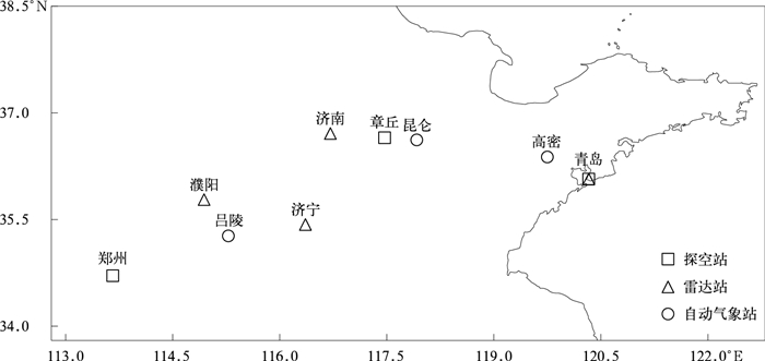
  • Fig. 1  Distribution of sounding, radar and automatic weather stations

    Fig. 2  500 hPa geopotential height (the contour,unit:dagpm) and 700 hPa wind (the barb) at 0800 BT 26 Jun, 0800 BT 30 Jun and 0800 BT 2 Jul in 2022

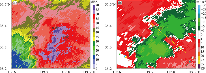
    Fig. 3  Composite reflectivity(a) and 0.5° elevation radial velocity(b) by Qingdao dual polarization radar at 1454 BT 26 Jun 2022

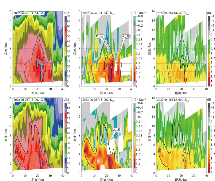
    Fig. 4  Cross-sections of ZH, KDP and ZDR along 316.5° radial direction by Qingdao dual polarization radar at 1454 BT and 1500 BT on 26 Jun 2022 (purple, red and blue horizontal solid lines denote heights of the wet bulb 0℃ layer, 0℃ layer and -20℃ layer, respectively)

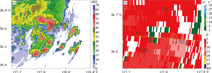
    Fig. 5  Composite reflectivity(a) and 0.5° elevation radial velocity(b) by Jinan dual polarization radar at 1242 BT 30 Jun 2022

    Fig. 6  Cross-sections of ZH, KDP and ZDR along 97° radial direction by Qingdao dual polarization radar at 1237 BT and 1242 BT on 30 Jun 2022 (purple, red and blue horizontal solid lines denote heights of the wet bulb 0℃ layer, 0℃ layer and -20℃ layer, respectively)

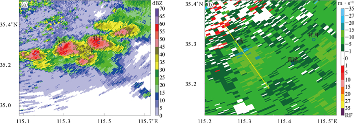
    Fig. 7  Composite reflectivity(a) and 0.5° elevation radial velocity(b) by Puyang dual polarization radar at 1536 BT 2 Jul 2022

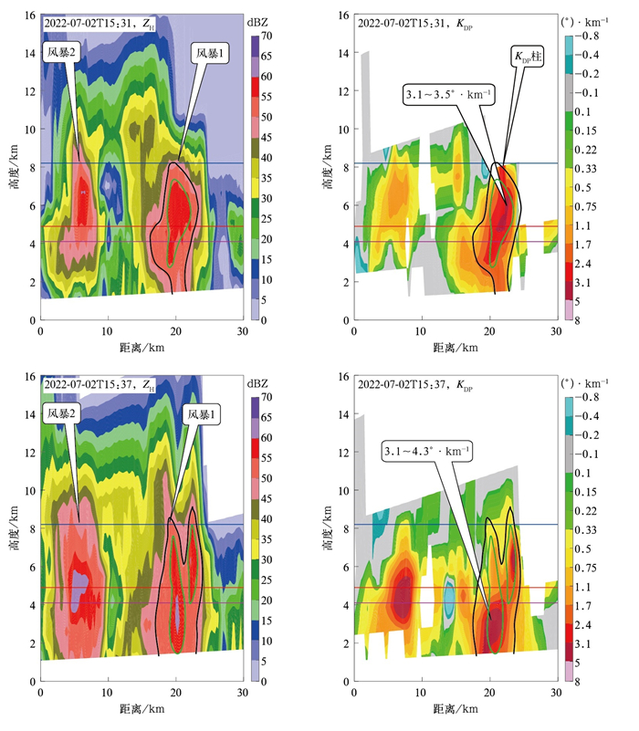
    Fig. 8  Cross-sections of ZH and KDP along 258° radial direction by Jining dual polarization radar at 1531 BT and 1537 BT on 2 Jul 2022 (purple, red and blue horizontal solid lines denote heights of the wet bulb 0℃ layer, 0℃ layer layer and -20℃ layer, respectively)

    Table  1  Environmental physical parameters obtained by sounding at Qingdao, Zhangqiu and Zhengzhou

    物理量 青岛站
    2022-06-26T08:00
    章丘站
    2022-06-30T08:00
    郑州站
    2022-07-02T08:00
    K指数/℃ -5.5 35 35
    850 hPa和500 hPa的温差/℃ 30 25 26
    有利抬升指数/℃ -6.8 -4.1 -3.9
    对流有效位能/(J·kg-1) 1880 1010 1820
    对流抑制位能/(J·kg-1) 0 0 0
    600 hPa下沉对流有效位能/(J·kg-1) 1760 470 935
    0~6 km垂直风切变/(m·s-1) 5.9 9.7 5.9
    0~3 km垂直风切变/(m·s-1) 6.6 10.4 4.3
    整层比湿度积分/(g·kg-1) 2810 4186 4109
    干层强度/℃ 45 6 13.5
    夹卷层平均风速/(m·s-1) 8.2 9.9 5.0
    湿球0℃层高度/km 3.2 4.2 4.1
    0℃层高度/km 4.9 4.4 4.9
    -10℃层高度/km 6.7 6.2 6.6
    -20℃层高度/km 8.1 7.9 8.2
    DownLoad: Download CSV

    Table  2  Radar characteristics for storms

    风暴 ZDR柱高度/km KDP柱高度/km -10℃层ZDR柱面积/(距离库数量) -10℃层KDP柱面积/(距离库数量)
    T-2 T-1 T T-2 T-1 T T-2 T-1 T T-2 T-1 T
    6·26 6.7 6.7 7.5 7.5 8.8 7.5 8 5 6 35 20 5
    6·30 6.8 6.8 6.7 9.1 7.5 7.1 6 3 7 8 11 6
    7·2 8.0 8.0 9.3 8.5 28 9 47 34
    DownLoad: Download CSV
  • [1]
    Fujita T T.Manual of Downburst Identification for Project NIMROD.SMRP Research Paper156.Chicago: University of Chicago, 1978: 1-104.
    [2]
    Zheng Y G, Zhou K H, Sheng J, et al. Advances in techniques of monitoring, forecasting and warning of severe convective weather. J Appl Meteor Sci, 2015, 26(6): 641-657. doi:  10.11898/1001-7313.20150601
    [3]
    Fujita T T, Byers H R. Spearhead echo and downburst in the crash of an airliner. Mon Wea Rev, 1977, 105(2): 129-146. doi:  10.1175/1520-0493(1977)105<0129:SEADIT>2.0.CO;2
    [4]
    Johns R H, Doswell C A Ⅲ. Severe local storms forecasting. Wea Forecasting, 1992, 7(4): 588-612. doi:  10.1175/1520-0434(1992)007<0588:SLSF>2.0.CO;2
    [5]
    Gao X M, Yu X D, Wang L J, et al. Comparative analysis of two strong convections triggered by sea-breeze front in Shandong Peninsula. J Appl Meteor Sci, 2018, 29(2): 245-256. doi:  10.11898/1001-7313.20180210
    [6]
    Wang H, Li Y, Song L L, et al. Comparison of characteristics and environmental factors of thunderstorm gales over the Sichuan-Tibet Region. J Appl Meteor Sci, 2020, 31(4): 435-446. doi:  10.11898/1001-7313.20200406
    [7]
    Wang H, Li Y, Wen Y R. Observational characteristics of a hybrid severe convective event in the Sichuan-Tibet Region. J Appl Meteor Sci, 2021, 32(5): 567-579. doi:  10.11898/1001-7313.20210505
    [8]
    Sheng J, Zheng Y G, Shen X Y, et al. Evolution and mechanism of a rare squall line in early spring of 2018. Meteor Mon, 2019, 45(2): 141-154. https://www.cnki.com.cn/Article/CJFDTOTAL-QXXX201902001.htm
    [9]
    Yu X D, Zhang A M, Zheng Y Y, et al. Doppler radar analysis on a series of downburst events. J Appl Meteor Sci, 2006, 17(4): 385-393. doi:  10.3969/j.issn.1001-7313.2006.04.001
    [10]
    Przybylinski R W. The bow echo: Observations, numerical simulations, and severe weather detection methods. Wea Forecasting, 1995, 10(2): 203-218. doi:  10.1175/1520-0434(1995)010<0203:TBEONS>2.0.CO;2
    [11]
    Smull B F, Houze R A Jr. Rear inflow in squall line with trailing stratiform precipitation. Mon Wea Rev, 1987, 115(12): 2869-2889. doi:  10.1175/1520-0493(1987)115<2869:RIISLW>2.0.CO;2
    [12]
    Eilts M D, Johnson J T, Mitchell E D, et al. Damaging Downburst Prediction and Detection Algorithm for the WSR-88D//Preprints, 18th Conference on Severe Local Storms. San Francisco, CA, Amer Meteor Soc, 1996: 541-545.
    [13]
    Wang X M, Zhou X G, Yu X D. Comparative study of environmental characteristics of a windstorm and their impacts on storm structures. Acta Meteor Sinica, 2013, 71(5): 839-852. https://www.cnki.com.cn/Article/CJFDTOTAL-QXXB201305004.htm
    [14]
    Wang F X, Yu X D, Pei Y J, et al. Radar echo characteristics of thunderstorm gales and forecast key points in Hebei Province. J Appl Meteor Sci, 2016, 27(3): 342-351. doi:  10.11898/1001-7313.20160309
    [15]
    Wang Y T, Wang X M, Yu X D. Radar characteristics of straight-line damaging wind producing supercell storms. J Appl Meteor Sci, 2022, 33(2): 180-191. doi:  10.11898/1001-7313.20220205
    [16]
    Wang Y, Zheng Y Y, Zhuang X R, et al. Statistical analysis of the structural characteristics of typical downbursts in Jiangsu Province, China. Acta Meteor Sinica, 2022, 80(4): 592-603. https://www.cnki.com.cn/Article/CJFDTOTAL-QXXB202204008.htm
    [17]
    Wang X M, Yu X D, Fei H Y, et al. A review of downburst genesis mechanism and warning. Meteor Mon, 2023, 49(2): 129-145. https://www.cnki.com.cn/Article/CJFDTOTAL-QXXX202302001.htm
    [18]
    Wu C, Liu L P, Yang M L, et al. Key technologies of hydrometeor classification and mosaic algorithm for X-band polarimetric radar. J Appl Meteor Sci, 2021, 32(2): 200-216. doi:  10.11898/1001-7313.20210206
    [19]
    Li Z, Wu C, Liu L P, et al. Error evaluation and hydrometeor classification method of dual polarization phased array radar. J Appl Meteor Sci, 2022, 33(1): 16-28. doi:  10.11898/1001-7313.20220102
    [20]
    Guo F Y, Diao X G, Ma Y, et al. Characteristics of the dual-polarization structure and raindrop size distribution of a squall line in Shandong. Acta Meteor Sinica, 2023, 81(2): 328-339. https://www.cnki.com.cn/Article/CJFDTOTAL-QXXB202302010.htm
    [21]
    Diao X G, Li F, Wan F J. Comparative analysis on dual polarization features of two severe hail supercells. J Appl Meteor Sci, 2022, 33(4): 414-428. doi:  10.11898/1001-7313.20220403
    [22]
    Kumjian M R, Ganson S M, Ryzhkov A V. Freezing of rain drops in deep convective updrafts: A microphysical and polarimetric model. J Atmos Sci, 2012, 69(12): 3471-3490.
    [23]
    Diao X G, Guo F Y. Analysis of polarimetric signatures in the supercell thunderstorm occurred in Zhucheng on 16 August 2019. Acta Meteor Sinica, 2021, 79(2): 181-195. https://www.cnki.com.cn/Article/CJFDTOTAL-QXXB202102001.htm
    [24]
    Loney M L, Zrnić D S, Straka J M, et al. Enhanced polarimetric radar signatures above the melting level in a supercell storm. J Appl Meteor, 2002, 41(12): 1179-1194.
    [25]
    van Lier-Walqui M, Fridlind A M, Ackerman A S, et al. On polarimetric radar signatures of deep convection for model evaluation: Columns of specific differential phase observed during MC3E. Mon Wea Rev, 2016, 144(2): 737-758.
    [26]
    Wakimoto R M, Bringi V N. Dual-polarization observations of microbursts associated with intense convection: The 20 July storm during the MIST project. Mon Wea Rev, 1988, 116(8): 1521-1539.
    [27]
    Scharfenberg K A. Polarimetric Radar Signatures in Microburst-producing Thunderstorms//31st Int Conf on Radar Meteorology. Seattle: Amer Meteor Soc, 2003, 8B4.
    [28]
    Kuster C M, Heinselman P L, Schuur, T J. Rapid-update radar observations of downbursts occurring within an intense multicell thunderstorm on 14 June 2011. Wea Forecasting, 2016, 31(3): 827-851.
    [29]
    Kuster C M, Bowers B R, Carlin J T, et al. Using KDP cores as a downburst precursor signature. Wea Forecasting, 2021, 36(4): 1183-1198.
    [30]
    Wang X, Wang H L, He J X, et al. Automated recognition of macro downburst using Doppler weather radar. Atmos, 2022, 13(5). DOI:  10.3390/atmos13050672.
    [31]
    Smith T M, Elmore K L, Dulin, S A. A damaging downburst prediction and detection algorithm for the WSR-88D. Wea Forecasting, 2004, 19(2): 240-250.
    [32]
    Miller P W, Mote T L. Characterizing severe weather potential in synoptically weakly forced thunderstorm environments. Nat Hazards Earth Syst Sci, 2018, 18: 1261-1277.
    [33]
    Yu X D, Wang X M, Li W L, et al. Thunderstorm and Strong Convection Nowcasting. Beijing: China Meteorological Press, 2020.
    [34]
    McCarthy J, Serafin R, Wilson J, et al. Addressing the microburst threat to aviation: Research-to-operations success story. Bull Amer Meteor Soc, 2022, 103(12). DOI:  10.1175/BAMS-D-22-0038.1.
    [35]
    Zhou H F, Diao X G, Zhao Q, et al. Cause analysis of a continuous downburst weather. J Arid Meteor, 2017, 35(4): 641-648. https://www.cnki.com.cn/Article/CJFDTOTAL-GSQX201704015.htm
    [36]
    Ma S P, Wang X M, Yu X D. Environmental parameter characteristics of severe wind with extreme thunderstorm. J Appl Meteor Sci, 2019, 30(3): 292-301. doi:  10.11898/1001-7313.20190304
    [37]
    Chen S Q, Zhang L N, Yu X D, et al. Environmental conditions of three squall lines in the north part of Zhejiang Province. J Appl Meteor Sci, 2017, 28(3): 357-368. doi:  10.11898/1001-7313.20170309
    [38]
    Liu H E. Characteristics and numerical simulation of microburst. Acta Meteor Sinica, 2001, 59(2): 183-195. https://cpfd.cnki.com.cn/Article/CPFDTOTAL-DIDD200109002A5E.htm
    [39]
    Hubbert J C, Wilson J W, Weckwerth T M, et al. S-Pol's polarimetric data reveal detailed storm features (and insect behavior). Bull Amer Meteor Soc, 2018, 99(10): 2045-2060.
    [40]
    Ryzhkov A V, Kumjian M R, Ganson S M, et al. Polarimetric radar characteristics of melting hail. Part Ⅱ: Practical implications. J Appl Meteor Climatol, 2013, 52(12): 2871-2886.
    [41]
    Duan Y P, Wang D H, Liu Y. Radar analysis and numerical simulation of strong convective weather for "Oriental Star" depression. J Appl Meteor Sci, 2017, 28(6): 666-677. doi:  10.11898/1001-7313.20170603
    [42]
    Mahale V N, Zhang G F, Xue M. Characterization of the 14 June 2011 Norman, Oklahoma, downburst through dual-polarization radar observations and hydrometeor classification. J Appl Meteor Climatol, 2016, 55(12): 2635-2655.
  • 加载中
  • -->

Catalog

    Figures(8)  / Tables(2)

    Article views (226) PDF downloads(82) Cited by()
    • Received : 2023-05-04
    • Accepted : 2023-08-02
    • Published : 2023-11-27

    /

    DownLoad:  Full-Size Img  PowerPoint