 DownLoad:

|
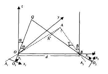
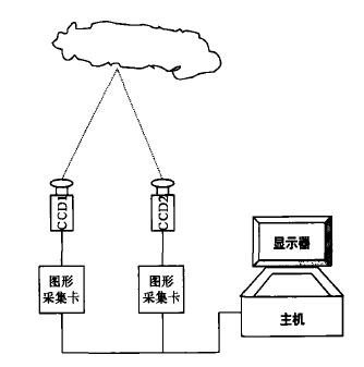
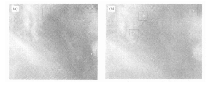
| Citation: | Tan Yongbo, Tao Shanchang1, Lǜ Weitao, et al. Observation of cloud base height through double location digital photography system. J Appl Meteor Sci, 2005, 16(5): 629-637.

|


|
|

|
| [1] |
Long C N, DeLuisi J J.Development of an Automated Hemi spheric Sky Imager for Cloud Fraction Retrievals.Proceedings of the 10th Symposium on Meteorological Observations and Inst rumen tat ion, Phoenix Arizona1.1998.171~174.
|
| [2] |
霍娟, 吕达仁.全天空数字相机测量云量的初步研究.南京气象学院学报, 2002, 25(2):242~246. http://www.cnki.com.cn/Article/CJFDTOTAL-NJQX200202014.htm
|
| [3] |
Jia Z.Geometric Retrieval of Cloud Top Height from MISR Imagery.In :Optical Remote Sensing of the Atmosphere and Clouds.Proceedings of SPIE, Vol.3501, 1998.531~541.
|
| [4] |
谢兴生, 陶善昌, 周秀骥.数字摄像法测量气象能见度.科学通报,1999, 44(1):97~100. http://www.cnki.com.cn/Article/CJFDTOTAL-KXTB199901021.htm
|
| [5] |
吕伟涛, 陶善昌, 谭涌波, 等.数字摄像能见度观测系统中实用黑体技术的应用.应用气象学报, 2003, 14(6):691~699. http://qikan.camscma.cn/jams/ch/reader/view_abstract.aspx?file_no=20030687&flag=1
|
| [6] |
吕伟涛, 陶善昌, 谭涌波.双亮度差方法测量白天气象能见度时的误差分析.应用气象学报, 2005, 16(5):619~628. http://qikan.camscma.cn/jams/ch/reader/view_abstract.aspx?file_no=20050580&flag=1
|
| [7] |
刘庆金.单点双站三角形交会法.测绘通报, 2001,(2):34~35. http://www.cnki.com.cn/Article/CJFDTOTAL-CHTB200103014.htm
|
| [8] |
袁伟, 金学军.双星定位的三参数方法及其精度分析.中国空间科学技术, 2003, (5):22~27. http://www.cnki.com.cn/Article/CJFDTOTAL-ZGKJ200305004.htm
|
| [9] |
何斌, 马天予, 王运坚, 等.Visual C ++ 数字图像处理.北京:人民邮电出版社, 2001.491~598.
|

Figures(7) / Tables(2)
