| Citation: |
Mu Xiyu, Dang Renqing, Chen Qiuping, et al. Radar data analysis and numerical simulation of a squall line. J Appl Meteor Sci, 2007, 18(1): 42-49. .

|
Fig 1. Backgroud surrouding situation at 850 hPa, 00:00, Apr 12, 2003
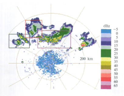
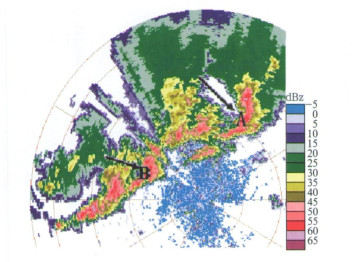
Fig 2. Radar reflectivity of Jianyang, 05:30, Apr 12, 2003
(the range is 100 km, the elevation is 1.5°)
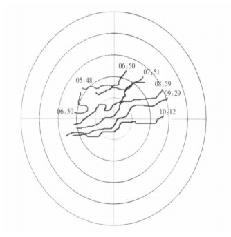
Fig 3. The frontal of 1.5°elevation PPI reflectivity from 05:48 to 10:12
(the range is 100 km)
Fig 4. Radar reflectivity of Jianyang, 08:15, Apr 12, 2003 (the range is 40 km)
(a) 1.5°elevation, (b) 2.4°elevation
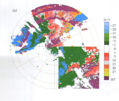
Fig 5. Radar PPI velocity at 1.5° elevation in Jianyang, 08:15, Apr 12, 2003
(the range is 50 km, the outermost circle is 30 km)
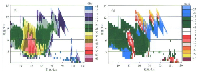
Fig 6. Cross section at 313° elevation of Jianyang Radar, 125.9 km, 08:15, Apr 12, 2003
(a) reflectivity cross section, (b) velocity cross section
Fig 7. Radar reflectivity at 1.5° elevation of Jianyang, 08:15, Apr 12, 2003
(the range is 50 km, the outermost circle is 30 km)
Fig 8. Difference of vertical velocity distribution at 500 hPa, 06:00, Apr 12, 2003
(black lines indicate altitude, unit: m)
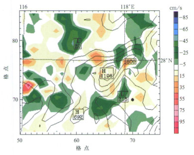
Fig 9. Model simulated stream at 900 hPa, 10:00, Apr 12, 2003
(shading areas indicate radar reflectivity, unit: dBz; structure in red pane is cyclonic and the one in green is anti-cyclonic)
|
Robert H J, William D H. Derechos: Widespread convectively induced windstorms. Wea Foresting, 1987, 2: 32-49. DOI: 10.1175/1520-0434%281987%29002%3C0032%3ADWCIW%3E2.0.CO%3B2
|
|
Fujita T T. Manual of Downburst Identification for Project NIMROD. Department of Geophysical Sciences, University of Chicago, Satellite and Mesometeorology Research Paper, 1978, 156, 104.
|
|
Fujita T T, Fernando C. An analysis of three weather-related aircraft accidents. Bull Amer Meteor Soc, 1978, 58 (11): 1164-1181. http://adsabs.harvard.edu/abs/1977BAMS...58.1164T
|
|
Burgess D W, Bradley F S. Doppler Radar Observations of a Bow Echo Associated with a Longtrack Severe Windstorm. Preprints, 16th Conf on Severe Local Storms, Amer Meteor Soc, 1993: 203-208.
|
|
Przybylinski R W. The bow echo: observations, numerical simulations, and severe weather detection method. Wea Foresting, 1995, 10: 203-218. DOI: 10.1175/1520-0434%281995%29010%3C0203%3ATBEONS%3E2.0.CO%3B2
|
|
Weisman M L. The genesis of severe, long-lived bow echos. J Atmos Sci, 1993, 50: 645-670. DOI: 10.1175/1520-0469(1993)050<0645:TGOSLL>2.0.CO;2
|
|
Kilmowski B A, Przybylinski R W, Schmocker G K, et al. Observation of the Formation and Early Evolution of Bow Echoes. Preprints, 20th Conf on Severe Local Storms, Orlando, FL, Amer Meteor Soc, 2000: 44-47.
|
|
Przybylinski R W, DeCaire. Radar Signatures Associated with the Derecho, One Type of Mesoscale Convective System. Preprints, 14th Conf on Severe Local Storms, Indianapolis, IN, American Meteorology Society, 1985: 461-465.
|
|
张鸿发, 龚乃虎, 贾维, 等.平凉地区强对流钩状回波特征的观测研究.大气科学, 1997, 21(3): 401-412. http://www.cnki.com.cn/Article/CJFDTOTAL-DQXK704.002.htm
|
|
Akos H, Istvan G. Severe Convective storms and associated phenomena in Hungary. Atmosphere Research, 2001, 56: 127-146. DOI: 10.1016/S0169-8095(00)00094-6
|
|
Rudolf Katlenbo ck. The outbreak of severe storms along convergence lines northeast of the Alps. Case study of the 3 August 2001 mesoscale convective system with a pronounced bow echo. Atmospheric Research, 2004, 70: 55-75. DOI: 10.1016/j.atmosres.2003.11.003
|
|
Weisman M L, Trapp R J. Low-level mesovorteces within squall lines and bow echoes. Part Ⅰ: Overview and dependence on environmental sheer. Mon Wea Rev, 2003, 131: 2779-2803. DOI: 10.1175/1520-0493(2003)131<2779:LMWSLA>2.0.CO;2
|
|
Trapp R J, Weisman M L. Low-level mesovortices within squall lines and bow echos. Part Ⅱ: Their gengesis and implications. Mon Wea Rev, 2003, 131: 2804-2823. DOI: 10.1175/1520-0493(2003)131<2804:LMWSLA>2.0.CO;2
|
|
Weisman M L, Davis C A. Mechanisms for the generation of mesoscale vortices within quasi-linear convective systems. J Atmos Sci, 1998, 55: 2603-2622. DOI: 10.1175/1520-0469(1998)055<2603:MFTGOM>2.0.CO;2
|
|
Xue Ming, Dan Dawson. Bright Bands, Bow Echoes and Mesoscale Convective Complexes, http://twister.ou.edu/MM2005/Chapter3.5.ppt.
|
|
Nolan T A, Justin M A, Lyndon S, et al. Rornadogenesis within Quasi-linear Convective Systems. Part Ⅱ: Preliminary WRF Simulation Results of the 29 June 1998 Derecho. 21st Conf on Severe Local Storms.http://ams.confex.com/ams/pdfpapers/46939.pdf.
|
|
徐枝芳, 党人庆, 葛文忠.两个中尺度气旋性涡旋合并的数值模拟.气候与环境研究, 2001, 6(2): 173-179. http://www.cnki.com.cn/Article/CJFDTOTAL-QHYH200102005.htm
|
|
Schmocher G K, Przybylinski R W, Lin Y J. Forecasting the Initial Onset of Damaging Downburst Winds Associated with a Mesoscale Convective System (MCS) Using the Mid-altitude Radial Convergence (MARC) Signature. Preprints. 15th Conf on Weather Analysis and Forecasting, Norfolk, VA. Amer Meteor Soc, 1996: 306-311.
|
|
张沛源, 陈荣林.多普勒速度图上的暴雨判据研究.应用气象学报, 1995, 6(3): 373-378. http://qikan.camscma.cn/jams/ch/reader/view_abstract.aspx?file_no=19950358&flag=1
|
|
孙建华, 赵思维.华南"94·6"特大暴雨的中尺度对流系统及其环境场研究Ⅱ.物理过程、环境场以及地形对中尺度对流系统的作用.大气科学, 2002, 26(5): 633-646. http://www.cnki.com.cn/Article/CJFDTOTAL-DQXK200205004.htm
|
| [1] | Huang Honghui, Li Lun. A Synchronous Variation Process of Tibetan Plateau Vortex and Southwest Vortex[J]. Journal of Applied Meteorological Science, 2023, 34(4): 451-462. DOI: 10.11898/1001-7313.20230406 |
| [2] | Kong Qi, Zheng Yongguang, Chen Chunyan. Synoptic Scale and Mesoscale Characteristics of 7·17 Urumqi Heavy Rainfall in 2007[J]. Journal of Applied Meteorological Science, 2011, 22(1): 12-22. |
| [3] | Yang Yinming, Gu Wenlong, Zhao Ruilei3, Liu Jie. The Statistical Analysis of Low Vortex During Meiyu Season in the Lower Reaches of the Yangtze[J]. Journal of Applied Meteorological Science, 2010, 21(1): 11-18. |
| [4] | Jiao Meiyan, Li Chuan, Li Yanxiang. MESOSCALE ANALYSES OF A SICHUAN HEAVY RAINFALL[J]. Journal of Applied Meteorological Science, 2005, 16(5): 699-704. |
| [5] | Zhang Tengfei, Zhang Jie, Guo Rongfen. DOPPLER RADAR ECHO FEATURE AND ENVIRONMENTAL CONDITION ANALYSIS OF A MESOSCALE RAIN BELT[J]. Journal of Applied Meteorological Science, 2005, 16(1): 70-77. |
| [6] | Zhu Xiaoyan, Xue Qiufang. RADAR OBSERVATION AND ANALYSIS OF MESO-SCALE VORTEX[J]. Journal of Applied Meteorological Science, 2004, 15(1): 117-125. |
| [7] | Wang Jianjie, Wang Yingchun, Cui Bo, Lu Duanjun, Yu Wei, Guo Xiaorong, Chen Dehui. Development and Real Time Application of Nonhydrostatic Mesoscale NWP System for Beijing Area[J]. Journal of Applied Meteorological Science, 1999, 10(4): 384-393. |
| [8] | A Case Analysis on Meosocale Structure of Severe Southwest Vortex[J]. Journal of Applied Meteorological Science, 1998, 9(3): 273-282. |
| [9] | Xu Xianan. A Study on the Surface Mesoscale Systems of the Landed Typhoon Polly (No.9216)[J]. Journal of Applied Meteorological Science, 1996, 7(3): 267-274. |
| [10] | Xiang Xukang Ma Lan Wang Dachang, . The Mesoscale Analysis of the Mei–yu Front Cloud System in 1991[J]. Journal of Applied Meteorological Science, 1993, 4(3): 286-292. |
 DownLoad: