
 DownLoad:

|
| Citation: | Zhang Yaping, Cheng Minghu, Xu Hui, et al. Application of radar rainfall estimates to runoff simulation in Foziling Basin. J Appl Meteor Sci, 2007, 18(3): 295-305.

|
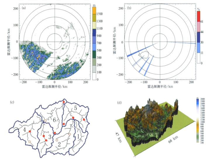
Fig. 1 Presentation of the study area (a) relief map of the Hefei radar and the location of Foziling basin, (b) beam blockage of Hefei radar at elevation of 0.5° and location of the Foziling basin, (c) a sketch map of the 6 subcatchments of the Foziling basin from 1:250000 DEM and the location of the rain gauge network (solid squares for evaluation and circles for adjustment), (d) the 3D view of the Foziling basin

Fig. 2 The 3D views of 6 subcatchments in the Foziling basin
(a) subcatchment 1, (b) subcatchment 2, (c) subcatchment 3, (d) subcatchment 4, (e) subcatchment 5, (f) subcatchment 6
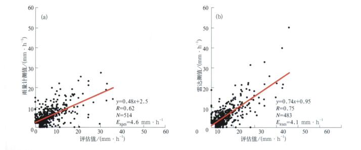
Fig. 3 Scatterplots of the hourly precipitation calculated from the rain gauge data (a) and the radar data (b)
(the regression line, correlation coeffecient R between compared quangtites, the number of calculated rainfall values N, and the root mean squared error ERMS are also given in each plot)
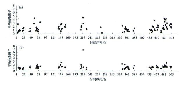
Fig. 4 Temporal variations of the averaged adjustment factors from June 20 to July 12, 2003 (a)6 rain gauges for adjustment, (b)2 rain gauges for adjustment
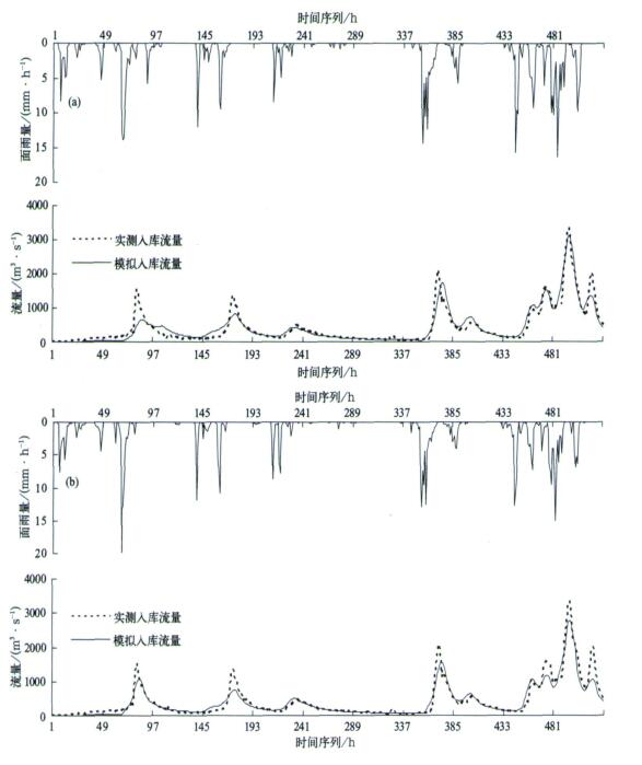
Fig. 5 Observed and simulated discharges from 01:00 on June 20 to 00:00 on July 12, 2003 for the Foziling basin (a) from the raingauge-based mean areal rainfall of subcatchments using 6 rain gauges (the upper curve shows the correspongding mean areal rainfall for the Foziling basin), (b) from the adjusted radar-based mean areal rainfall of subcatchments using 6 rain gauges (the upper curve shows the correspongding mean areal rainfall for the Foziling basin)
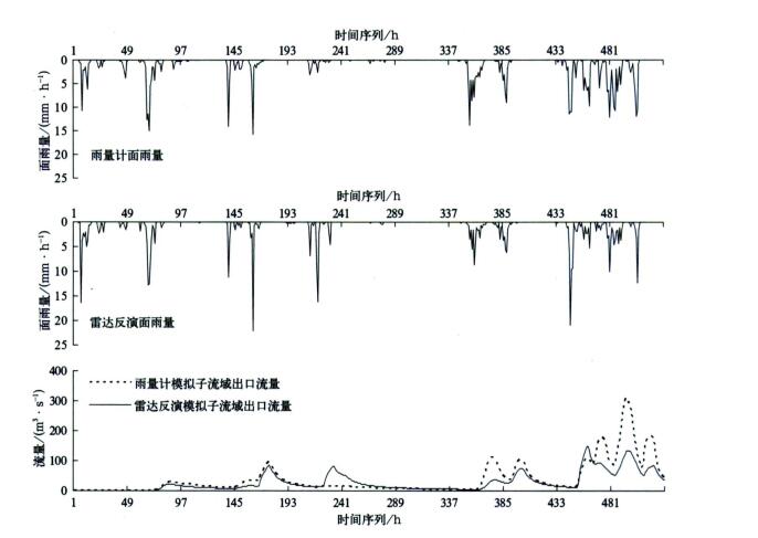
Fig. 6 The mean areal rainfall estimates and simulated discharges from 01:00 on June 20 to 00:00 on July 12, 2003 for subcatchmennt 1 of the Foziling basin
Table 1 List of the subcatchments with their corresponding area and distance to the outlet of the Foziling basin
|
|
Table 2 Evaluation of the hourly precipitation calculated from the rain gauge data

|
Table 3 Evaluation of the accumulated hourly precipitation derived from the radar data

|
Table 4 Coefficient of efficiency (E) of hydrographs simulated using rain gages and radar estimates for the Foziling basin

|
Table 5 Statistics of mean areal rainfall estimates and simulated runoff depths for the Foziling basin with its 6 subcatchments from June 20 to July 12, 2003

|
| [1] |
Anagnostou E N, Krajewski W F. Calibration of the WSR-88D precipitation processing subsystem. Wea Forecasting, 1999, 13:396-406. https://www.researchgate.net/publication/252452408_Calibration_of_the_WSR-88D_Precipitation_Processing_Subsystem
|
| [2] |
Finnerty B D, Smith M B, Seo D J, et al. Space-time scale sensitivity of the Sacramento model to radar-gage precipitation inputs. J Hydrol, 1997, 203:21-38. doi: 10.1016/S0022-1694(97)00083-8
|
| [3] |
万玉发, 杨洪平, 肖艳娇, 等.多普勒天气雷达站址视程的客观分析技术.应用气象学报, 2000, 11(4):440-447. http://qikan.camscma.cn/jams/ch/reader/view_abstract.aspx?file_no=20000465&flag=1
|
| [4] |
Kucera P A, Krajewski W F, Young C B. Radar beam occultation studies using GIS and DEM technology:An example study of Guam. J Atmos Oceanic Technol, 2004, 21:995-1006. doi: 10.1175/1520-0426(2004)021<0995:RBOSUG>2.0.CO;2
|
| [5] |
Martz W, Garbrecht J. Numerical definition of drainage network and subcatchment areas from digital elevation models. Computers & Geosciences, 1992, 18(6):747-761. https://www.researchgate.net/publication/222786989_Numerical_Definition_of_Drainage_Networks_and_Subcatchment_Areas_from_Digital_Elevation_Models
|
| [6] |
Garbrecht J, Campbell J. TOPAZ:An Automated Digital Landscape Analysis Tool for Topographic Evaluation, Drainage Identification, Watershed Segmentation and Subcatchment Parameterization. TOPAZ User Manual, USDA-ARS, Oklahoma, 1997:1-138.
|
| [7] |
Viessman W, Lewis G L. Introduction to Hydrology (4th ed). Harper-Collins, 1996:1-760.
|
| [8] |
Sun X, Mein R G, Keenan T D, et al. Flood estimation using radar and raingauge data. J Hydrology, 2000, 239:4-18. doi: 10.1016/S0022-1694(00)00350-4
|
| [9] |
刘晓阳, 毛节泰, 李纪人, 等.雷达联合雨量计估测降水模拟水库入库流量.水利学报, 2002, (4):342-349. http://www.cnki.com.cn/Article/CJFDTOTAL-SLXB200204009.htm
|
| [10] |
Ren liliang, Li Chunhong, Wang Meirong. Application of radar-measured rain data in hydrological processes modeling during the intensified observation period of HUBEX. Adv Atmos Sci, 2003, 20(2):205-211. doi: 10.1007/s00376-003-0005-8
|
| [11] |
Liu Xiaoyang, Mao Jietai, Zhu Yuanjing, et al. Runoff simulation using radar and rain gauge data. Adv Atmos Sci, 2003, 20 (2):213-218. doi: 10.1007/s00376-003-0006-7
|
| [12] |
Fulton R A, Breidenbach J P, Seo D, et al. The WSR-88D rainfall algorithm. Wea Forecasting, 1998, 13:377-395. doi: 10.1175/1520-0434(1998)013<0377:TWRA>2.0.CO;2
|
| [13] |
尹忠海, 张沛源.利用卡尔曼滤波校准方法估算区域降水量.应用气象学报, 2005, 16(2):213-219. http://qikan.camscma.cn/jams/ch/reader/view_abstract.aspx?file_no=20050226&flag=1
|
| [14] |
史锐, 程明虎, 崔哲虎, 等.用反射率因子垂直廓线联合雨量计校准估测夏季区域强降水.应用气象学报, 2005, 16 (6):737-745. http://qikan.camscma.cn/jams/ch/reader/view_abstract.aspx?file_no=20050696&flag=1
|
| [15] |
吴翠红, 万玉发, 吴涛, 等.雷达回波垂直廓线及其生成方法.应用气象学报, 2006, 17(2):232-239. http://qikan.camscma.cn/jams/ch/reader/view_abstract.aspx?file_no=20060239&flag=1
|
| [16] |
曹俊武, 刘黎平, 陈晓辉, 等.3836C波段双线偏振多普勒雷达及其在一次降水过程中的应用研究.应用气象学报, 2006, 17(2):192-200. http://qikan.camscma.cn/jams/ch/reader/view_abstract.aspx?file_no=20060233&flag=1
|
| [17] |
Wilson J W, Brandes E A. Radar measurement of rainfall— a summary. Bull Amer Meteor Soc, 1979, 60:1048-1058. doi: 10.1175/1520-0477(1979)060<1048:RMORS>2.0.CO;2
|
| [18] |
Colle B, Westrick K, Mass C F. Evaluation of MM5 and Eta-10 precipitation forecasts over the Pacific Northwest during the cool season. Wea Forecasting, 1999, 14:137-154. doi: 10.1175/1520-0434(1999)014<0137:EOMAEP>2.0.CO;2
|
| [19] |
Beven K J, Kirkby M J. A Physically based variable contributing area model of basin hydrology. Hydrology Sci Bull, 1979, 24: 43-69. doi: 10.1080/02626667909491834
|
| [20] |
Beven K J, Kirkby M J, Schoffield N, et al. Testing a physically-based flood forecasting model (TOPMODEL) for three UK catchments. J Hydrology, 1984, 69:119-143. doi: 10.1016/0022-1694(84)90159-8
|
| [21] |
Beven K J, Lamb R, Quinn P, et al. TOPMODEL ∥VP Singh, Computer Models of Watershed Hydrology, Chapter 18. Water Resources Publications, 1995:627-668.
|
| [22] |
Saulnier G M, Beven K J, Obled C H. Including spatially variable soil depths in TOPMODEL. J Hydrology, 1998, 202: 158-172. https://www.researchgate.net/publication/223514856_Including_spatially_variable_soil_depths_in_TOPMODEL
|
| [23] |
郭方, 刘新仁, 任立良.以地形为基础的流域水文模型———Topmodel及其拓宽应用.水科学进展, 2000, 11(3):296-301. http://www.cnki.com.cn/Article/CJFDTOTAL-SKXJ200003011.htm
|
| [24] |
熊立华, 郭生练, 胡彩虹.TOPMODEL在流域径流模拟中的应用研究.水文, 2002, 22(5):5-8. http://www.cnki.com.cn/Article/CJFDTOTAL-SWZZ200205001.htm
|
| [25] |
陈仁升, 康尔泗, 杨建平, 等.TOPMODEL模型在黑河干流出山径流模拟中的应用.中国沙漠, 2003, 23(4):428-433. http://www.cnki.com.cn/Article/CJFDTotal-ZGSS200304015.htm
|
| [26] |
Nash J E, Sutcliffe J V. River flow forecasting through conceptual models, Ⅰ:A discussion of principles. J Hydrol, 1970, 10: 282-290. doi: 10.1016/0022-1694(70)90255-6
|

Figures(6) / Tables(5)
