| Citation: | Wang Nan, Liu Liping, Xu Baoxiang, et al. Recognizing low-altitude wind shear and convergence line with Doppler radar. J Appl Meteor Sci, 2007, 18(3): 314-320.

|
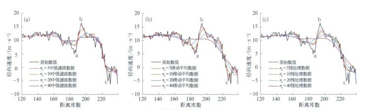
Fig. 1 Contrast of data pretreatment
(a) contrast of media filtering, (b) contrast of moving average, (c) contrast of media filtering first and then moving average
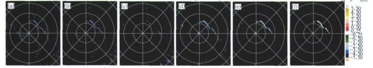
Fig. 2 Radial shear of elevation 0.53° in Jinan at 17:40 on June 21, 2004
(a)-(c) radial shear calculated with original data (show gate:2.5 m·s-1·km-1) n=10(a), n=20(b), n=40(c), (d)-(f) radial shear calculated with pretreated data (show gate:1.5 m·s-1·km-1) n=10(d), n=20(e), n=40(f)
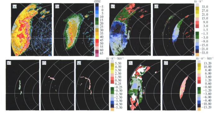
Fig. 3 Doppler radar echo and detecting result of a squall line in Guangzhou at 01:32 on March 22, 2005
(a) reflectivity in elevation 0.53°, (b) reflectivity in elevation 2.5°, (c) velocity in elevation 0.53°, (d) velocity in elevation 2.5°, (e) radial shear in elevation 0.53° (show gate: 1.2 m·s-1·km-1), (f) azimuthal shear in elevation 0.53° (show gate:l.5 m·s-1·km-1), (g) combined shear in elevation 0.53° (show gate: 1.7 m·s-1·km-1), (h) vertical shear between elevation 0.53° and 1.49°, (i) vertical shear between elevation 2.5° and 3.5°
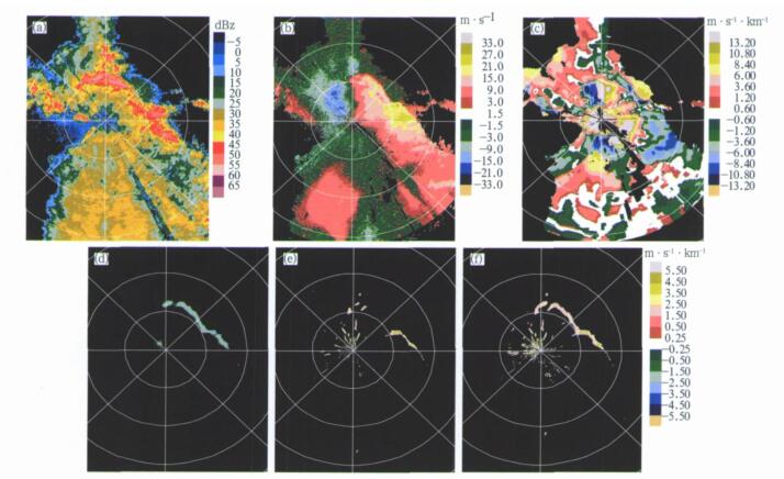
Fig. 4 Doppler radar echo and detecting result of a strong convective line at 17:34 on June 21, 2004
(a) reflectivity in elevation 0.53°, (b) velocity in elevation 0.53°, (c) vertical shear between elevation 0.53° and 1.49°, (d) radial shear in elevation 0.53° (show gate:1.2 m·s-1·km-1), (e) azimuthal shear in elevation 0.53° (show gate:l.7 m·s-1·km-1), (f) combined shear in elevation 0.53° (show gate:1.7 m·s-1·km-1)
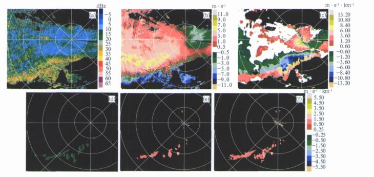
Fig. 5 Doppler radar echo and detecting result of a mixing cloud in Jinzhou at 1l:49 on July 22, 2002
(a) reflectivity in elevation 0.6°, (b) velocity in elevation 0.6°, (c) vertical shear between elevation 0.6° and 1.4°, (d) radial shear in elevation 0.6° (show gate:0.5 m·s-1·km-1), (e) azimuthal shear in elevation 0.6° (show gate:0.8 m·s-1·km-1), (f) combined shear in elevation 0.6* (show gate:0.8 m·s-1·km-1)
| [1] |
朱炳海, 王鹏飞, 束家鑫.气象学词典.上海:上海辞书出版社, 1985:96-97;927.
|
| [2] |
张家国, 吴翠红, 王珏, 等.一次冷锋大暴雨过程的多普勒雷达观测分析.应用气象学报, 2006, 17(2):226-231. http://qikan.camscma.cn/jams/ch/reader/view_abstract.aspx?file_no=20060238&flag=1
|
| [3] |
何彩芬, 姚秀萍, 胡春蕾, 等.一次台风前部龙卷的多普勒天气雷达分析.应用气象学报, 2006, 17(3):370-375. http://qikan.camscma.cn/jams/ch/reader/view_abstract.aspx?file_no=20060363&flag=1
|
| [4] |
姚建群, 戴建华, 姚祖庆.一次强飑线的成因及维持和加强机制分析.应用气象学报, 2005, 16(6):746-753. http://qikan.camscma.cn/jams/ch/reader/view_abstract.aspx?file_no=20050697&flag=1
|
| [5] |
陶祖钰, 曾立新.中尺度系统的模拟Doppler图像.应用气象学报, 1993, 4(1):8-15. http://qikan.camscma.cn/jams/ch/reader/view_abstract.aspx?file_no=19930106&flag=1
|
| [6] |
陈明轩, 俞小鼎, 谭晓光, 等.对流天气临近预报技术的发展与研究进展.应用气象学报, 2004, 15(6):754-766. http://qikan.camscma.cn/jams/ch/reader/view_abstract.aspx?file_no=20040693&flag=1
|
| [7] |
Wilson J W, Roberts R D, Kessinger C, et al. Microburst wind structure and evaluation of Doppler radar for airport wind shear detection. J Appl Meteor, 1984, 23:898-915. doi: 10.1175/1520-0450(1984)023<0898:MWSAEO>2.0.CO;2
|
| [8] |
Uyeda H, Zrnić D S. Automatic detection of gust fronts. J Atmos Oceanic Technol, 1986, 3:36-50. doi: 10.1175/1520-0426(1986)003<0036:ADOGF>2.0.CO;2
|
| [9] |
Hermes L G, Witt A, Smith S D, et al. The gust-front detection and wind-shift algorithms for the terminal Doppler weather radar system. J Atmos Oceanic Technol, 1993, 10:693-708. doi: 10.1175/1520-0426(1993)010<0693:TGFDAW>2.0.CO;2
|
| [10] |
Zrnić D S, Burgess D W, Hennington L D. Automatic detection of mesocyclonic shear with Doppler radar. J Atmos Oceanic Technol, 1985, 2:425-438. doi: 10.1175/1520-0426(1985)002<0425:ADOMSW>2.0.CO;2
|
| [11] |
Campbell S D, Olson S H. Recognizing low-altitude wind shear hazards from Doppler weather radar:An artificial intelligence approach. J Atmos Oceanic Technol, 1987, 4:5-18. doi: 10.1175/1520-0426(1987)004<0005:RLAWSH>2.0.CO;2
|
| [12] |
胡明宝, 谈曙青, 汤达章, 等.单部多卜勒雷达探测低空风切变方法.南京气象学院学报, 2000, 23(1):113-118. http://www.cnki.com.cn/Article/CJFDTOTAL-NJQX200001017.htm
|
| [13] |
中国人民解放军总参谋部气象局.多普勒天气雷达资料分析与应用.北京:解放军出版社, 2000:150-159.
|
| [14] |
陆汉城, 杨国祥.中尺度天气原理和预报.北京:气象出版社, 2004:106-114.
|
| [15] |
张玉玲.中尺度大气动力学引论.北京:气象出版社, 1999:147-176.
|

Figures(5)


 DownLoad: