Guan Min, Yang Zhongdong. Application of on-board GPS data and high-precision orbit model to polar satellites orbits calculation. J Appl Meteor Sci, 2007, 18(6): 748-753.
Citation: Guan Min, Yang Zhongdong. Application of on-board GPS data and high-precision orbit model to polar satellites orbits calculation. J Appl Meteor Sci, 2007, 18(6): 748-753.

Application of On-board GPS Data and High-precision Orbit Model to Polar Satellites Orbits Calculation

  • Received Date: 2007-01-10
  • Rev Recd Date: 2007-02-27
  • Publish Date: 2007-12-31
  • A high precision orbit model based on numerical integration is introduced. Satellite's instantaneous position and velocity are derived from the position data measured by on-board GPS receiver, and then they are used as initial value to predict the orbit by high precision numerical integration. The six orbital elements which are used to describe the motion of satellite can be transformed to the satellite's position and velocity, and vice versa. The satellite's instantaneous orbital elements at time t1 can be calculated from satellite's two position vectors and at time t2 and t2 respectively, then the satellite's instantaneous position and velocity at time t2 can be obtained. There are many perturbing terms that have been considered in the satellite's high precision orbit model, including the aspherical gravitations of the earth, the perturbations that arise from the gravitational attraction of the sun and the moon, the solar radiation pressure and the atmospheric drag. The earth gravity model that is used is the EGM-96 model of degree and order of 360. Numerical methods are used to solve the equation of the satellite's motion. The variable order and stepsize method DE/DEABM are used for the numerical integration.This new method are applied to Terra/Aqua-MODIS satellite's orbit calculation. Satellite Terra's position vectors r1 at time t1 and r2 at time t2 are used to compute the instantaneous velocity vector. The result shows that the departure between the calculated observation and the GPS measurement is very small with the error of instantaneous speed less than±0.1 m/s. Then they are used as initial input to predict one of Terra/MODIS' further 10-minute orbit by applying the high precision orbit model. It shows that the satellite's position and velocity vectors and range which are predicted by this method are all consistent with the measurements by GPS. The following results are gained that the position error is between-20 m and +5 m, the velocity error is less than±0.2 m/s. The same method are used to compute Aqua/MODIS' orbit. The Aqua's position vectors error between the predictions from high precision orbit model and the GPS measurements is less than 40 m, the error of predicted velocity vectors is less than±0.4 m/s.Because of the high precision and the continuous stability in certain time, the high precision orbit model based on numerical integration can be used to verify the reliability of GPS measurement results if the initial input is correct, and substitute the wrong GPS measurement value. Further more, the new method is suitable for FY-3 satellite's orbit computation.
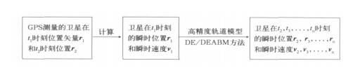
  • Fig. 1  Flow chart of satellite orbit calculation based GPS data and high precision orbit model

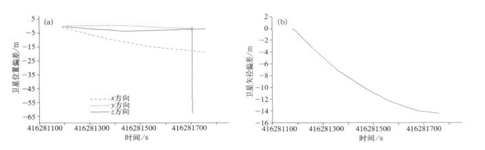
    Fig. 2  The error of Terra's position between calculated method and the real measurement (a) position, (b) radius vector

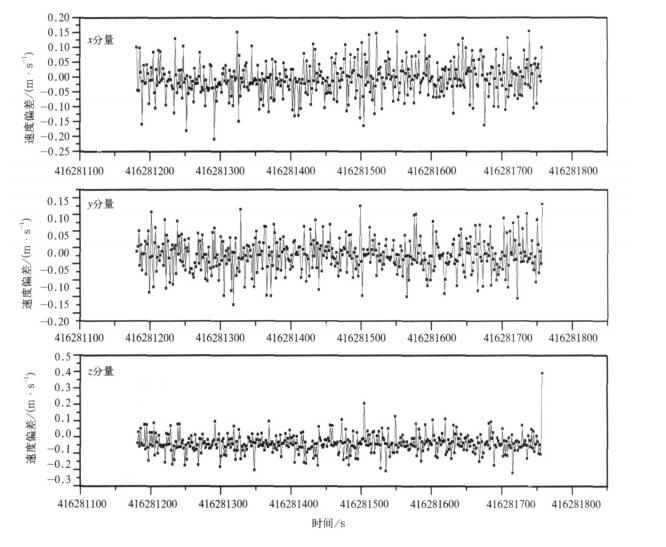
    Fig. 3  The error of Terra's velocity between calculated method and the real measurement

    Table  1  Analysis of GPS measurement data

  • [1]
    刘林.天体力学方法.南京:南京大学出版社, 1998.
    [2]
    刘林.人造地球卫星轨道力学.北京:高等教育出版社, 1992.
    [3]
    George W R, Daniel G B, William J E. Precise AVHRR image navigation. IEEE Transactions on Geoscience and Remote Sensing, 1994, 32(3):644-657. doi:  10.1109/36.297982
    [4]
    [5]
    Robert E W, Masahiro N, Albert J F, et al. Achieving sub-pixel geolocation accuracy in support of MODIS land science. Remote Sens Environ, 2002, 83:31-49. doi:  10.1016/S0034-4257(02)00085-8
    [6]
    Oliver Montenbruck, Eberhard Gill. Satellite Orbits. Berlin:Springer-Verlag, Germany, 2000.
    [7]
    Nisihama M, Wolfe R, Fleig A, et al. MODIS Geolocation Algorithm and Error Analysis Tools. Geoscience and Remote Sensing Symposium Proceedings, 2000, 5:2053-2055. http://ieeexplore.ieee.org/document/858269/
  • 加载中
  • -->

Catalog

    Figures(3)  / Tables(1)

    Article views (3909) PDF downloads(2888) Cited by()
    • Received : 2007-01-10
    • Accepted : 2007-02-27
    • Published : 2007-12-31

    /

    DownLoad:  Full-Size Img  PowerPoint