
 DownLoad:

|
| Citation: | Wang Jiechun, Jiang Jixi, Feng Jianbi, et al. The synoptic conceptual model of 6-hour tropical cyclone rainfall and its application in Guangxi. J Appl Meteor Sci, 2007, 18(6): 840-848.

|
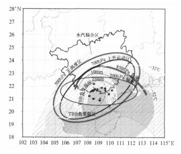
Fig. 1 Conceptual model of 6 h zonal precipitation
(the black dots denote the centers of TCs, and the gray region surrounded by white line represents cloud)
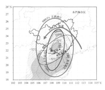
Fig. 2 Conceptual model I of 6 h meridional precipitation
(others same as in Fig. 1)

Fig. 3 Conceptual model Ⅱ of 6 h meridional precipitation
(others same as in Fig. 1)
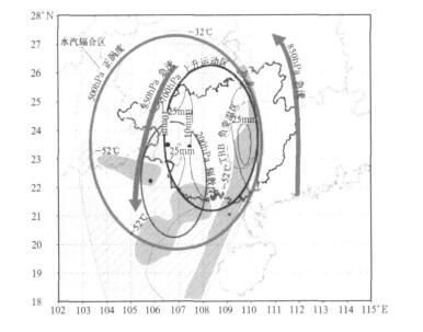
Fig. 4 Conceptual model Ⅲ of 6 h meridional precipitation
(others same as in Fig. 1)
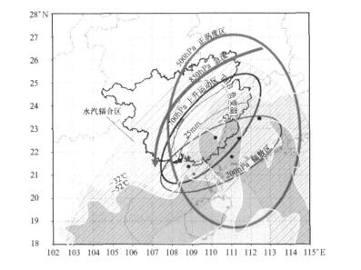
Fig. 5 Conceptual model of 6 h NE—SW orientated precipitation
(others same as in Fig. 1)
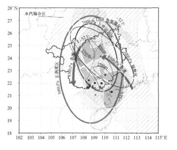
Fig. 6 Conceptual model of 6 h NW—SE orientated precipitaion
(others same as in Fig. 1)
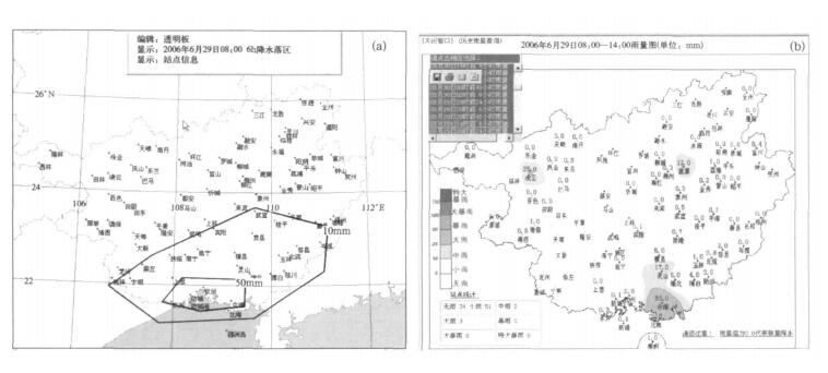
Fig. 7 6 h precipitation forecasting test at 08:00—14:00 on June 29, 2006
(a) forecasting result, (b) observation result
Table 1 The converted process of 6 h TC precipitation types
|
|
Table 2 Relationship between low-level jet and precipitation types

|
Table 3 Relationship between 200 hPa divergence field and precipitation types

|
Table 4 Relationship between 700 hPa ascending motion and precipitation types

|
Table 5 Relationship between 500 hPa vorticity field and precipitation types

|
Table 6 Main factors of each rainfall type

|
Table 7 Main factors about the rainfall intensity

|
Table 8 Precipitation forecasting test result of TC NO.6 in Auguest, 2006

|
| [1] |
朱乾根,林锦瑞,寿绍文, 等.天气学原理与方法.北京: 气象出版社, 1992: 551-555.
|
| [2] |
陈联寿.热带气旋研究和业务预报技术的发展.应用气象学报, 2006, 17(6): 672-681. http://qikan.camscma.cn/jams/ch/reader/view_abstract.aspx?file_no=200606116&flag=1
|
| [3] |
陶诗言.中国之暴雨.北京: 科学出版社, 1980: 121-133.
|
| [4] |
田辉,马开玉,林振山. 华南、华东沿海登陆台风暴雨和大风的分析.应用气象学报, 1999, 10(增刊): 148-152. http://kns.cnki.net/KCMS/detail/detail.aspx?dbcode=CJFQ&dbname=CJFD9899&filename=YYQX9S1.017&v=MTg3MDhaT2RxRlNEa1d3PT1QRFRhZHJyYkg4L01yb2dxRjU0T2ZnZzV6aEFVNGpoNE9YNlRySDAzZWJPVFJibWQ=
|
| [5] |
贺海晏,简茂球,宋丽莉, 等.近 50a 广东登陆热带气旋的若干气候特征.气象科学, 2003, 23(4): 401-408. http://www.cnki.com.cn/Article/CJFDTOTAL-QXKX200304002.htm
|
| [6] |
姚才,黄明策,贺海晏.影响华南西部的登陆热带气旋的若干气候特征.中山大学学报(自然科学版), 2005, 44(5): 103- 107. http://www.cnki.com.cn/Article/CJFDTOTAL-ZSDZ200505026.htm
|
| [7] |
孔宁谦,杨澄梅.广西沿海热带气旋暴雨分析.海洋预报, 2000, 17(3): 44-48. http://www.cnki.com.cn/Article/CJFDTOTAL-HYYB200003006.htm
|
| [8] |
郑传新,周军.盛夏影响广西的两类台风暴雨对比分析.气象, 2003, 29(10): 13-16. http://www.cnki.com.cn/Article/CJFDTOTAL-QXXX200310002.htm
|
| [9] |
李菁,卢伟萍,姚才, 等.广西特大暴雨的特征分析.广西气象, 2002, 23(4): 9-12. http://www.cnki.com.cn/Article/CJFDTOTAL-GXQX200204004.htm
|
| [10] |
钮学新,董加斌,杜惠良.华东地区台风降水及影响降水因素的气候分析.应用气象学报, 2005, 16(3): 402-407. http://qikan.camscma.cn/jams/ch/reader/view_abstract.aspx?file_no=20050349&flag=1
|
| [11] |
欧坚莲. 2003 年影响广西的两次台风过程对比分析.广西气象, 2004, 25(增刊): 37-38. http://www.cnki.com.cn/Article/CJFDTOTAL-GXQX2004S1012.htm
|
| [12] |
黄明策,姚才,李菁. 低空急流对广西热带气旋特大暴雨的影响及概念模式. 广西气象, 2005, 26(1): 5-9. http://www.cnki.com.cn/Article/CJFDTOTAL-GXQX200501002.htm
|
| [13] |
高安宁.影响广西热带气旋暴雨的环境流场和一些物理量特征分析. 广西气象, 2004, 25(3): 1-5. http://www.cnki.com.cn/Article/CJFDTOTAL-GXQX200403001.htm
|
| [14] |
王捷纯,江吉喜.热带气旋登陆华南前后的强降水大尺度环境场特征. 应用气象学报, 2006, 17(3): 288-294. http://qikan.camscma.cn/jams/ch/reader/view_abstract.aspx?file_no=20060351&flag=1
|
| [15] |
Michael Fritscn J, Carbone R E. Research and Development to Improve Quantitative Precipitation Forecasts in the Warm Season, a Synopsis of the March 2002. USWRP Workshop and Statement of Priority Recommendations, NCAR/TN-458 + PROC, NCAR TECHNICAL NOTE, 2003.
|

Figures(7) / Tables(8)
