 DownLoad:

|
| Citation: | Li Xuemin, Zhou Dingwen, Fan Guangzhou, et al. The lag relationship between winter NDVI over Tibetan Plateau and temperature of the Southwest China. J Appl Meteor Sci, 2008, 19(2): 161-170.

|
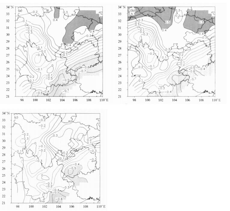
Fig. 1 The correlation coefficient distributions between NDVI over Tibetan Plateau and summer temperatures of Southwest China
(areas exceeding 90% confidence level are shaded) (a) mean temperature, (b) highest temperature, (c) lowest temperature
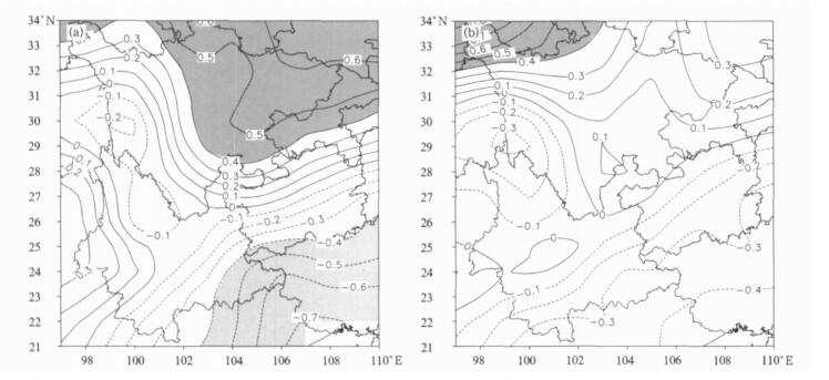
Fig. 2 The correlation between winter NDVI over two parts of Tibetan Plateau and summer highest temperature of Southwest China
(a) the West Plateau, (b) the East Plateau (areas exceeding 90% level are shaded)
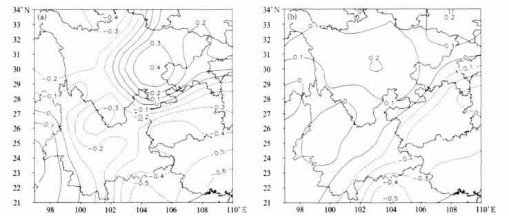
Fig. 3 The correlation between winter NDVI over two parts of Tibetan Plateau and summer lowest temperature of Southwest China (a) the West Plateau, (b) the East Plateau
(areas exceeding 90% level are shaded)

Fig. 4 Composite differences of temperatures in Southwest China between the winter high and low NDVI years (a) mean temperature, (b) highest temperature, (c) lowest temperature
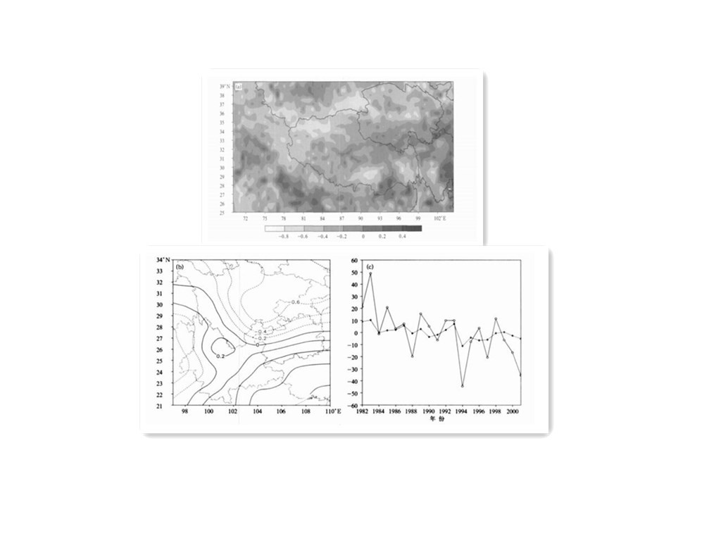
Fig. 5 Spatial and temporal distributions for the first mode (a) preceding winter NDVI over Tibetan Plateau, (b) summer mean temperature over Southwest China, (c) temporal coefficient
(solid line:NDVI; dashed line:temperature)
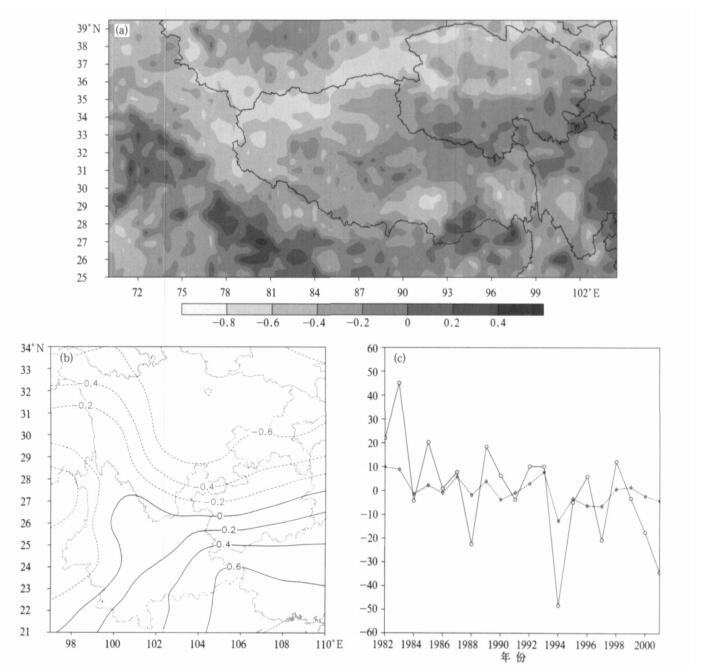
Fig. 6 Spatial and temporal distributions for the first mode (a) preceding winter NDVI over Tibetan Plateau, (b) summer highest temperature over Southwest China, (c) temporal coefficient
(solid line:NDVI; dashed line:temperature)

Fig. 7 Spatial and temporal distributions for the first mode (a) preceding winter NDVI over Tibetan Plateau, (b) summer lowest temperature over Southwest China, (c) temporal coefficient
(solid line:NDVI; dashed line:temperature)
Table 1 Variance contribution of the first 4 SVD modes between winter NDVI over Tibetan Plateau and summer mean, highest and lowest temperature of Southwest China
|
|
| [1] |
Charney J G. Dynamics of deserts and drought in the Sahel. Q J R Meteorol Soc, 1975, 101(428):193-202. doi: 10.1002/(ISSN)1477-870X
|
| [2] |
Henderson-Sellers A, Gornitz V. Possible climate impacts of land cover transformations, with particular emphasis on tropical deforestation. Clim Change, 1984, 6(3-4):231-258. http://d.scholar.cnki.net/detail/SSJD_U/SSJD00001770131
|
| [3] |
Xue Y. The impact of desertification in the Mongolian and the Inner Mongolian Grassland on the regional climate. J Climate, 1996, 9(9):2173-2189. doi: 10.1175/1520-0442(1996)009<2173:TIODIT>2.0.CO;2
|
| [4] |
张井勇, 董文杰, 符淙斌.中国北方和蒙古南部植被退化对区域气候的影响.科学通报, 2005, 50(1):53-58. http://www.cnki.com.cn/Article/CJFDTOTAL-KXTB20050100B.htm
|
| [5] |
陈隆勋, 周秀骥, 李维亮.中国近80年来气候变化特征及其形成机制.气象学报, 2004, 62(5):634-645. http://www.cnki.com.cn/Article/CJFDTOTAL-QXXB200405010.htm
|
| [6] |
方之芳, 李超, 李贤琅.青藏高原温度场与贵州干旱的联系.高原气象, 1996, 15(4):496-502. http://www.cnki.com.cn/Article/CJFDTOTAL-GYQX604.013.htm
|
| [7] |
叶月珍, 方之芳.青藏高原热力状况与四川盆地汛期降水的联系.高原气象, 1999, 18(2):162-170. http://www.cnki.com.cn/Article/CJFDTOTAL-GYQX902.003.htm
|
| [8] |
周锁铨, 陈万隆, 徐海明.青藏高原及其周围植被对夏季气候影响的套网格数值试验比较.南京气象学院学报, 1998, 21 (1):85-93. http://www.cnki.com.cn/Article/CJFDTOTAL-NJQX801.011.htm
|
| [9] |
范广洲, 程国栋.影响青藏高原植被生理过程与大气CO2浓度及气候变化的相互作用.大气科学, 2002, 26(4):509-518. http://www.cnki.com.cn/Article/CJFDTotal-DQXK200204007.htm
|
| [10] |
班军梅, 缪启龙, 李雄.西南地区近50年来气温变化特征研究.长江流域资源与环境, 2006, 15(3):346-351. http://www.cnki.com.cn/Article/CJFDTOTAL-CJLY200603014.htm
|
| [11] |
Zhou Dingwen, Fan Guangzhou, Huang Ronghui, et al. Interannual variability of the normalized difference vegetation index on the Tibetan Plateau and its relationship with climate change. Adv Atmos Sci, 2007, 24(3):474-484. doi: 10.1007/s00376-007-0474-2
|
| [12] |
赵平, 陈隆勋.35年来青藏高原大气热源气候特征及其与中国降水的关系.中国科学 (D辑), 2001, 31(4):327-332. http://www.cnki.com.cn/Article/CJFDTOTAL-JDXK200104008.htm
|
| [13] |
王澄海, 董文杰, 韦志刚.青藏高原季节冻融过程与东亚大气环流关系的研究.地球物理学报, 2003, 46(3):309-316. http://www.cnki.com.cn/Article/CJFDTOTAL-DQWX200303004.htm
|
| [14] |
John M Wallace, Catherine Smith, Christopher S Bretherton. Singular value decomposition of wintertime sea surface temperature and 500 mb height anomalies. J Climate, 1992, 5:561-576. doi: 10.1175/1520-0442(1992)005<0561:SVDOWS>2.0.CO;2
|
| [15] |
丁裕国, 江志红.SVD方法在气象诊断分析中的普适性.气象学报, 1995, 54(3):365-371. http://www.cnki.com.cn/Article/CJFDTOTAL-QXXB603.010.htm
|
| [16] |
董敏, 朱文妹, 徐祥德.青藏高原地表热通量变化及其对初夏东亚大气环流的影响.应用气象学报, 2001, 12(4):458-468. http://qikan.camscma.cn/jams/ch/reader/view_abstract.aspx?file_no=20010460&flag=1
|
| [17] |
张井勇, 董文杰, 叶笃正, 等.中国植被覆盖对夏季气候影响的新证据.科学通报, 2003, 48(1):91-95. http://www.cnki.com.cn/Article/CJFDTOTAL-KXTB200301025.htm
|
| [18] |
徐兴奎, 陈红.中国西部地区地表植被覆盖和积雪覆盖变化对沙尘天气的影响.科学通报, 2006, 51(6):707-714. http://www.cnki.com.cn/Article/CJFDTOTAL-KXTB200606015.htm
|
| [19] |
Liu Zhengyu, Notaro M, Kutzbach J, et al. Assessing global vegetation-Climate feedbacks from observations. Meteorol Soc, 2006, 19:787-813. https://www.researchgate.net/publication/252958278_Assessing_Global_Vegetation_Climate_Feedbacks_from_Observations
|
| [20] |
高志球, 卞林根, 程彦杰, 等.利用生物圈模型 (SiB2) 模拟青藏高原那曲草原近地面层能量收支.应用气象学报, 2002, 13 (2):129-141. http://qikan.camscma.cn/jams/ch/reader/view_abstract.aspx?file_no=20020217&flag=1
|
| [21] |
莫申国, 张百平, 程维明, 等.青藏高原的主要环境效应.地理科学进展, 2004, 23(2):88-96. http://www.cnki.com.cn/Article/CJFDTOTAL-DLKJ200402010.htm
|
| [22] |
郭铌, 杨兰芳, 李民轩.利用气象卫星资料研究祁连山区植被和积雪变化.应用气象学报, 2003, 14(6):700-707. http://qikan.camscma.cn/jams/ch/reader/view_abstract.aspx?file_no=20030688&flag=1
|

Figures(7) / Tables(1)
