Yang Hongping, Zhang Peiyuan, Cheng Minghu, et al. The valid mosaic data region of the CINRAD network. J Appl Meteor Sci, 2009, 20(1): 47-55.
Citation: Yang Hongping, Zhang Peiyuan, Cheng Minghu, et al. The valid mosaic data region of the CINRAD network. J Appl Meteor Sci, 2009, 20(1): 47-55.

The Valid Mosaic Data Region of the CINRAD Network

  • Received Date: 2007-12-07
  • Rev Recd Date: 2008-07-25
  • Publish Date: 2009-02-28
  • Along the normal propagation path, the radar ray becomes higher and higher due to effects of the earth curvature and positive elevation angle of transmitter. Actually, radar waves are often blocked as they propagate through mountain areas. When radar beam has occultation, its real sample volume will be smaller than that of zero occultation, echo intensity of targets will be underestimated if it is partial occultation, and targets will be totally missed if complete occultation occurs. It is common practice now to use occultation rate for beam occultation correction. Assuming that radar waves propagate in standard atmosphere, occultation rates of radar beam herein are calculated with the high resolution digital elevation map data, and are utilized to analyze the valid mosaic data region of netted radars and to assess the beam occultation correction. Test shows that echo will be severely underestimated and waves can be considered to be completely blocked when the occultation rate is larger than 55 %. Based on that, in terms of the 14 elevation angles of two Volume Coverage Pattern modes, VCP11 and VCP12, the real detecting ranges of netted radars are obtained. The netted radars include the local CINRAD in Hunan, Jiangxi, Zhejiang, Fujian, Guangdong, Guangxi and Hainan provinces. Compared with the equivalent beam range at the same height, the valid data range of CAPPI is more suitable to represent the real detection range. Among the valid mosaic date regions at the height of 1500 m, 3000 m and 6000 m above the sea level, the largest blank area can be seen in the graph of 1500 m height, but can hardly be seen in that of 6000 m height. In the overlapping area of 6000 m height, most common grids can be detected by three radars or more, some by the maximum of six. Observations in VCP12, compared with that in VCP11 or in VCP21, are more useful to construct mosaic data not only because of its dense vertical sample in low elevation but also its larger valid data range in mountain areas. According to the definition formula of echo intensity, correction of intensities sampled in partial occultation range gates is obtained from its occultation rate. For instance, the correction value is 1.0 dB, 1.5 dB, 2.2 dB, 3.0 dB and 3.5 dB while the occultation rate is 20 %, 30 %, 40 %, 50 % and 55 % respectively. In the experiment of correction, base data are observed in the common latitude longitude grid at the same time by the two weather radars in Wenzhou and Ningbo. The common grids are separated into two groups. The group Ⅰ consists of the grids where Wenzhou radar has partial occultation and Ningbo radar has none. And the group Ⅱ consists of the grids where both two has no occultation. Therefore, the observations of Wenzhou radar are corrected in group Ⅰ, and correction is assessed by the observations of Ningbo radar. The results indicate that the correlative coefficient of corrected data is larger than that of uncorrected in group Ⅰ, and the values are close to that of group Ⅱ, the corrections are effective.
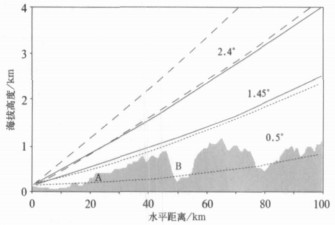
  • Fig. 1  An example of radar beams obscured by ground obstacles (shaded areas denote topograph)

    Fig. 2  The valid mosaic data regions of CINRAD network from Hunan, Jiangxi, Zhejiang, Fujian, Guangdong, Guangxi and Hainan with VCP11 or VCP12 at different altitudes

    (a) VCP11, at 1500 m, (b) VCP12, at 1500 m, (c) VCP11, at 3000 m, (d) VCP12, at 3000 m, (e) VCP11, at 6000 m, (f) VCP12, at 6000 m

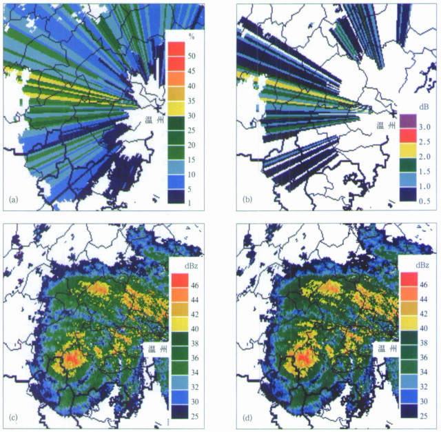
    Fig. 3  Occultation rates (unit:%) of the lowest elevation that Wenzhou radar observed at 14:31 on September 19, 2007

    (a), the correction values (unit:dB) for the partial occultation (b), the uncorrected (c) and the corrected (d) intensities of that equal to or greater than 26 dBz

    Fig. 4  Coverage of equivalent beam range (dashed line) and CAPPI valid data region (thin line denotes CP 11 and thick line denotes VCP12) at 6000 m above the sea level (distance between range ring is 150 km)

    Table  1  Elevation number and elevation angles of VCP11, VCP12, VCP21 and VCP31(unit:(°))

    Table  2  Results of comparing intensities without/with occultation corrections of Wenzhou radar echo with observations of Ningbo radar

  • [1]
    Doviak J R, Zrnic S D. Doppler Radar and Weather Observations.San Diego, CA:Academic Press, 1993:10-29.
    [2]
    张培昌, 杜秉玉, 戴铁丕.雷达气象学.北京:气象出版社, 2001:94-149.
    [3]
    盛裴轩, 毛节泰, 李建国, 等.大气物理学.北京:北京大学出版社, 2003:468-474.
    [4]
    王军, 林强, 米慈中, 等译.雷达手册 (第二版).北京:电子工业出版社, 2003:18-68.
    [5]
    O' Banon.Using a ' Terrain-based' Hybrid Scan to Improve WSR-88D Precipitation Estimates. Preprints, the 28th ICRM, 1997:506-507.
    [6]
    Fulton R A, Breidenbach J P, Seo D-J, et al. The WSR-88D rainfall algorithm. Wea Forecasting, 1998, 13:377-395. doi:  10.1175/1520-0434(1998)013<0377:TWRA>2.0.CO;2
    [7]
    张亚萍, 刘钧, 顾嵩山, 等.雷达定量估测区域降水波束阻挡系数的计算.南京气象学院学报, 2002, 25(5):640-647. http://www.cnki.com.cn/Article/CJFDTOTAL-NJQX200205008.htm
    [8]
    程明虎, 刘黎平, 张沛源, 等.暴雨系统的多普勒雷达反演理论和方法.北京:气象出版社, 2004:108-112.
    [9]
    张亚萍, 程明虎, 夏文梅, 等.天气雷达回波运动场估测及其在降水临近预报中的应用.气象学报, 2006, 64(5):631-646. http://www.cnki.com.cn/Article/CJFDTOTAL-QXXB200605009.htm
    [10]
    Lakshmanan V, Rabin R, DeBrunner V.Multiscale storm identification and forecast. J Atmos Res, 2003, 367-380. http://adsabs.harvard.edu/abs/2003AtmRe..67..367L
    [11]
    Zhang J, Howard K, Xia W, et al.Three-dimensional High-resolution National Radar Mosaic∥Preprints, the 11th Conference on Aviation, Range, and Aerospace Meteorology.Amer Meteor Soc, 2004.
    [12]
    Zhang J, Howard K, Gourley J J.Constructing three-dimensional multiple-radar reflectivity Mosaic:Examples of convective storms and stratiform rain echoes.J Atmos Oceanic Technic, 2005, 10:30-42.
    [13]
    肖艳姣, 刘黎平.新一代天气雷达网资料的三维格点化及拼图方法研究.气象学报, 2006, 64(5):647-657. http://www.cnki.com.cn/Article/CJFDTOTAL-QXXB200605010.htm
    [14]
    中国气象局.新一代天气雷达观测规定.北京:中国气象局, 2005.
    [15]
    刘黎平, 张沛源, 梁海河, 等.双多普勒雷达风场反演误差和资料的质量控制.应用气象学报, 2003, 14(1):17-29. http://qk.cams.cma.gov.cn/jams/ch/reader/view_abstract.aspx?file_no=20030103&flag=1
    [16]
    万玉发, 杨洪平, 肖艳娇, 等.多普勒天气雷达站址视程的客观分析技术.应用气象学报, 2000, 11(4):440-447. http://qk.cams.cma.gov.cn/jams/ch/reader/view_abstract.aspx?file_no=20000465&flag=1
  • 加载中
  • -->

Catalog

    Figures(4)  / Tables(2)

    Article views (4823) PDF downloads(2930) Cited by()
    • Received : 2007-12-07
    • Accepted : 2008-07-25
    • Published : 2009-02-28

    /

    DownLoad:  Full-Size Img  PowerPoint