
 DownLoad:

|
| Citation: | Zhou Bingrong, Li Fengxia, Shen Shuanghe, et al. Principal component analysis method acquiring soil moisture information from MODIS data. J Appl Meteor Sci, 2009, 20(1): 114-118.

|
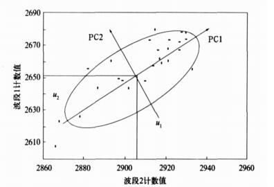
Fig. 1 Spacial characteristic transformation by principal component analysis
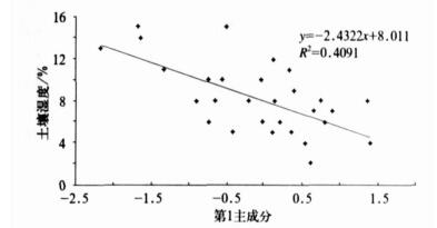
Fig. 2 Regression result of principal component factors and soil moisture
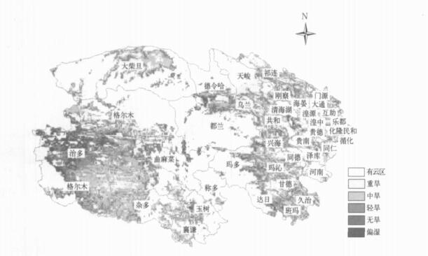
Fig. 3 Result of monitoring drought on Feb 18, 2004
Table 1 Correlation coefficient of factors in image infusing
|
|
Table 2 Comparison between RS monitoring value data and observing data(unit : %)

|
| [1] |
崔彩霞, 杨青, 杨莲梅. M ODIS资料用于塔克拉玛干沙漠地表温度计算方法初探.中国沙漠, 2003, 23(5):596-598. http://www.cnki.com.cn/Article/CJFDTOTAL-ZGSS200305024.htm
|
| [2] |
申广荣, 田国良.作物缺水指数监测旱情方法研究.干旱地区农业研究, 1998, 16(1): 123-128. http://www.cnki.com.cn/Article/CJFDTOTAL-GHDQ801.021.htm
|
| [3] |
Watson K, Pohn H A.Thermal inertia mapping from satellites discrimination of geologic units in Oman.J Res Geol Surv, 1974, 2(2): 147-158.
|
| [4] |
John C.Price, thermal inertia mapping :A new view of the earth.J Geophys Res, 1982, 87: 2582-2590.
|
| [5] |
张仁华.土壤含水量的热惯量模型及其应用.科学通报, 1991, 36(12): 924-927. http://www.cnki.com.cn/Article/CJFDTOTAL-KXTB199112013.htm
|
| [6] |
肖乾广, 陈维英, 盛永伟, 等.用气象卫星检测土壤水分的实验研究.应用气象学报, 1994, 5(3): 312-318. http://qk.cams.cma.gov.cn/jams/ch/reader/view_abstract.aspx?file_no=19940355&flag=1
|
| [7] |
王鹏新, 龚健雅, 李小文.条件温度植被指数及其在干旱监测中的应用.武汉大学学报, 2001, 26(5): 412-418. http://www.cnki.com.cn/Article/CJFDTOTAL-WHCH200105006.htm
|
| [8] |
刘志明, 张柏, 晏明, 等.土壤水分与干旱遥感研究的进展与趋势.地球科学进展, 2003, 18(4) :576-581. http://www.cnki.com.cn/Article/CJFDTOTAL-DXJZ200304014.htm
|
| [9] |
田国良.黄河流域典型地区遥感动态研究.北京:科学出版社, 1990: 122-132.
|
| [10] |
余涛, 田国良.热惯量法在监测土壤表层水分变化中的研究.遥感学报, 1997, 1(1) : 24-31. http://www.cnki.com.cn/Article/CJFDTOTAL-YGXB199701002.htm
|
| [11] |
刘安麟, 李星敏, 何延波, 等.作物缺水指数法的简化及在干旱遥感监测中的应用.应用生态学报, 2004, 15(2): 210-214. http://www.cnki.com.cn/Article/CJFDTOTAL-YYSB200402007.htm
|
| [12] |
郭广猛, 赵冰茹.使用MODIS数据监测土壤湿度.土壤, 2004, 36(2): 219-221. http://www.cnki.com.cn/Article/CJFDTOTAL-TURA200402021.htm
|
| [13] |
马霭乃.遥感信息模型.北京:北京大学出版社, 1997.
|
| [14] |
赵英时.遥感应用分析原理与方法.北京:科学出版社, 2003.
|
| [15] |
梅安新.遥感导论.北京:高等教育出版社, 2001.
|
| [16] |
王晓云, 郭文利, 奚文, 等.利用" 3S"技术进行北京地区土壤水分监测应用技术研究.应用气象学报, 2002, 13(4):422-429. http://qk.cams.cma.gov.cn/jams/ch/reader/view_abstract.aspx?file_no=20020457&flag=1
|
| [17] |
吴贤云, 丁一汇, 王琪.近40年长江中下游地区旱涝特点分析.应用气象学报, 2006, 17(1): 19-26. http://qk.cams.cma.gov.cn/jams/ch/reader/view_abstract.aspx?file_no=20060103&flag=1
|
| [18] |
延昊, 张国平.混合像元分解法提取积雪盖度.应用气象学报, 2004, 15(6): 665-671. http://qk.cams.cma.gov.cn/jams/ch/reader/view_abstract.aspx?file_no=20040681&flag=1
|

Figures(3) / Tables(2)
