
 DownLoad:

|
| Citation: | Wang Lirong, Bian Tao, Su Yuntao, et al. The application of clear air echo to early warning of severe convective weather. J Appl Meteor Sci, 2010, 21(5): 606-613.

|
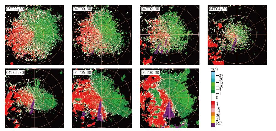
Fig. 1 The radial velocity PPIs from 22:30 3 August to 08:30 4 August 2009 (elevaton is 0.5°, the interval of adjacent rings is 25 km)
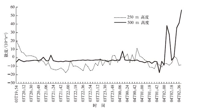
Fig. 2 The time series of the divergence at different height from 19:54 3 August to 02:36 4 August in 2009
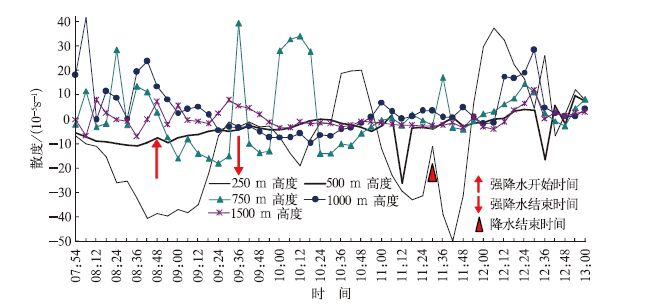
Fig. 3 The time series of the divergence at different height from 07:54 to 13:00 on 4 August 2009
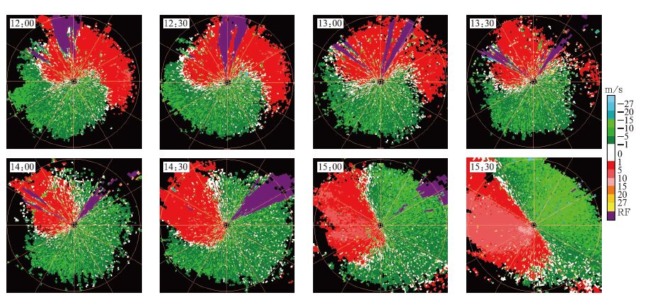
Fig. 4 The time series of the radial velocity PPIs from 12:00 to 15:30 on 27 August 2009 (the elevation is1.5°, the interval of adjacent rings is 25 km)
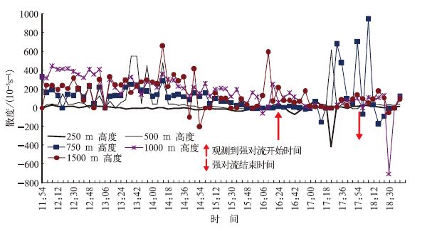
Fig. 5 The time series of the divergence at different height from 11:54 to 19:00 on 27 August 2009
Table 1 The rings in the height of 0—500 m in each elevation angles
|
|
Table 2 The analysis of convergence at diffrent height

|
Table 3 The score sheet of severe weather from June to August in2009

|
| [1] |
何立富,陈涛,周庆亮,等.北京"7.10"暴雨β-中尺度对流系统分析.应用气象学报,2007,18(5):655-665. http://qikan.camscma.cn/jams/ch/reader/view_abstract.aspx?file_no=200705100&flag=1
|
| [2] |
赵玮,王建捷.北京2006年夏季接连两场暴雨的观测对比分析.气象,2008,34(8):3-14. http://www.cnki.com.cn/Article/CJFDTOTAL-QXXX200808002.htm
|
| [3] |
王飞,张义军,赵均壮,等.雷达资料在孤立单体雷电预警中的初步应用.应用气象学报,2008,19(2):153-160. http://qikan.camscma.cn/jams/ch/reader/view_abstract.aspx?file_no=20080228&flag=1
|
| [4] |
夏文梅,张亚萍,汤达章.暴雨多普勒天气雷达资料的分析.南京气象学院学报,2002,25(6):787-794. http://www.cnki.com.cn/Article/CJFDTOTAL-NJQX200206008.htm
|
| [5] |
马清云,李泽椿,陶士伟.单部多普勒天气雷达风场反演及其在数值预报中的应用试验.应用气象学报,2001,12(4):488-493. http://qikan.camscma.cn/jams/ch/reader/view_abstract.aspx?file_no=20010463&flag=1
|
| [6] |
徐广阔,孙建华,雷霆,等.多普勒天气雷达资料同化对暴雨模拟的影响.应用气象学报,2009,20(1):36-46. http://qikan.camscma.cn/jams/ch/reader/view_abstract.aspx?file_no=20090105&flag=1
|
| [7] |
王楠,刘黎平,徐宝祥,等.利用多普勒雷达资料识别低空风切变和辐合线方法研究.应用气象学报,2007,18(3):314-320. http://qikan.camscma.cn/jams/ch/reader/view_abstract.aspx?file_no=20070353&flag=1
|
| [8] |
程向阳,王兴荣,胡雯,等.雷暴天气在多普勒雷达资料上的前兆特征分析.气象科学,2003.23(4):485-490. http://www.cnki.com.cn/Article/CJFDTOTAL-QXKX200304013.htm
|
| [9] |
李淑玲,刁秀广,朱敏,等.一次飑线过程多普勒雷达资料分析.气象,2009,35(3):60-65. http://www.cnki.com.cn/Article/CJFDTOTAL-XJQX200903014.htm
|
| [10] |
朱敏华,姜有山,周红根.两次暴雨过程的多普勒天气雷达资料对比分析.气象科学,2005,23(1):71-78. http://www.cnki.com.cn/Article/CJFDTOTAL-QXKX200501009.htm
|
| [11] |
王丽荣,胡志群,汤达章,等.多普勒雷达径向速度资料在对流天气预报中的应用.气象科学,2007,27(6):695-701. http://www.cnki.com.cn/Article/CJFDTOTAL-QXKX200706018.htm
|
| [12] |
胡明宝,高太长,汤达章.多普勒天气雷达资料分析与应用.北京:解放军出版社,2000:113-115.
|
| [13] |
Wood V T,Brown R A.Single Doppler velocity signature interpretation of nondivergent environmental winds.J Atmos Ocean Technol,1986,3(1):114-128. doi: 10.1175/1520-0426(1986)003<0114:SDVSIO>2.0.CO;2
|
| [14] |
Wood V T,Brown R A.Effects of radar proximity on single Doppler velocity signatures of axisymnetric rotation and divergence.Mon Wea Rev,1992,120:2798-2807. doi: 10.1175/1520-0493(1992)120<2798:EORPOS>2.0.CO;2
|
| [15] |
胡志群,汤达章,梁明珠,等.用改善的EVAD技术和变分法计算大气垂直速度.南京气象学院学报,2005,28(3):344-350. http://www.cnki.com.cn/Article/CJFDTOTAL-NJQX200503008.htm
|
| [16] |
Thomas M,Srivastava R C.An improved version of the extended velocity-azimuth display analysis of single-Doppler radar data.J Atmos Ocean Technol,1991,8(4):453-456. doi: 10.1175/1520-0426(1991)008<0453:AIVOTE>2.0.CO;2
|

Figures(5) / Tables(3)
