Sun Lihua, Wu Huanping, Zheng Jinwei, et al. Designing and implementation of meteorological information web sharing system based on flex. J Appl Meteor Sci, 2010, 21(6): 754-761.
Citation: Sun Lihua, Wu Huanping, Zheng Jinwei, et al. Designing and implementation of meteorological information web sharing system based on flex. J Appl Meteor Sci, 2010, 21(6): 754-761.

Designing and Implementation of Meteorological Information Web Sharing System Based on Flex

  • Received Date: 2009-11-25
  • Rev Recd Date: 2010-08-31
  • Publish Date: 2010-12-31
  • With the pace of meteorological service information accelerated, more and more kinds of comprehensive meteorological observation and forecast data have been produced. To share meteorological data timely and effectively online, the meteorological information delivering system is established based on Flex and Rich Internet Application (RIA) which are of advantage in internet GIS. On the basis of user requirement and the construction target analysis, a general framework composed of four layers is proposed for the Meteorological Information Web Sharing System. The data layer on the bottom mainly stores meteorological data, geo spatial data and socioeconomic data, providing fundamental data for upper layers. The upper service layer consists of various GIS services, Web services and LiveCycle Data Service. Different data and application services will be sent according to different requests from presentation layer. The presentation layer is composed of visual Flex controls, including map display object, geometric object, functional object etc. This layer communicates with data service layer and interacts with the client layer. The uppermost layer is the client layer with Flash plug in installed for running SWF files. The features of the sharing system are introduced from six aspects, including basic geographic information displaying, meteorological data displaying, information querying, data downloading, spatial analysis on meteorological data, and web map plotting/outputting. Finally, four key issues related to this system are further discussed. The first one is data organization and management. Massive data of the system are stored and managed by category. For instance, the view of existing data based on old database structure is newly designed for management, obtaining a minimum dataset satisfying constraint in order to improve data access efficiency. With respect to meteorological data stored as a file form, spatial database is adopted. Meanwhile, all data is created following by meta data tables. The second issue is meteorological data conversion. Utilizing model builder technology, some complicated geo processing models as tasks are established, which can automatically accomplish data conversion, data generation and data loading. The task can be done as a batch job by customizing parameters of the model manager. The third issue is cache technology for map services. Basic geographic map and meteorological services are cached with different strategies to improve the display efficiency. The last issue is map display technology based on Flex. Due to combination ArcGIS API for Flex with features and special effects of Flex, the meteorological information delivering system is notable and interactive.In conclusion, Flex and Flash are feasible in meteorological information sharing field, improving the display efficiency of meteorological data in internet GIS. The advantages of this system comparing with the conventional Web GIS in meteorological field are discussed. This system can also bring a high performance meteorological information sharing platform based on network for emergency and public meteorological services. It can also lay solid technique foundation for constructing more effective meteorological information delivering system in nationwide.
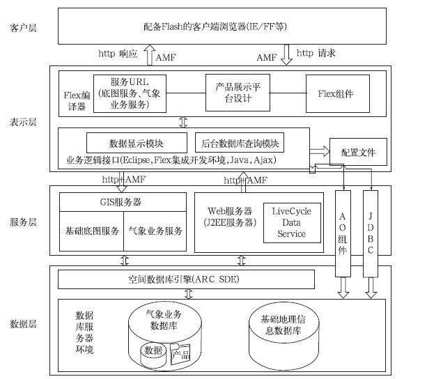
  • Fig. 1  Framework of the application system

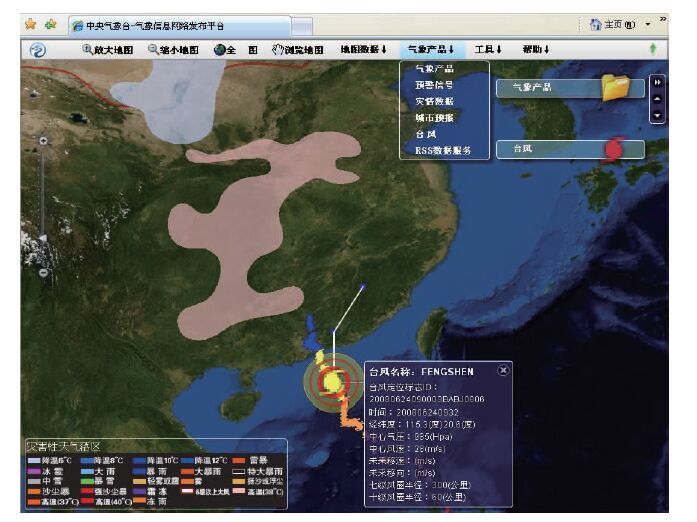
    Fig. 2  Main user interface of the system

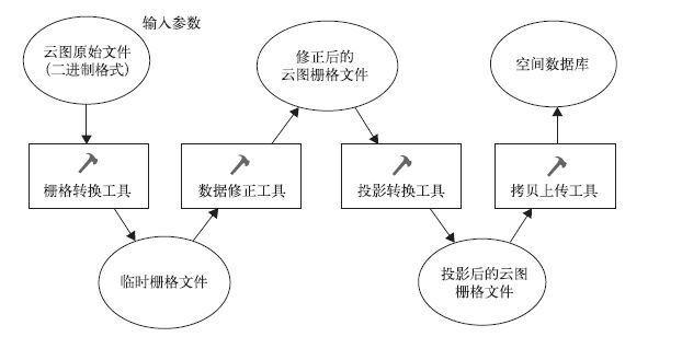
    Fig. 3  Background data process and conversion model of cloud picture

    Table  1  Pressure test of the system

  • [1]
    秦永生, 刘振乾.基于WebGIS的流溪河水库水质管理信息系统.人民黄河, 2009, 31(3):59-60. http://www.cnki.com.cn/Article/CJFDTOTAL-RMHH200903028.htm
    [2]
    王妍玮, 王述洋, 杨宏鹏, 等.基于B/S结构的WebGIS森林防火系统.林业劳动安全, 2007, 20(4):40-42.
    [3]
    宋易蔓, 朱世斌, 杨金玲.基于WebGIS的数字城市规划系统研究.测绘与空间地理信息, 2008, 31(1):39-42.
    [4]
    桂岚, 李跃军.基于WebGIS的交通基本建设管理信息系统.计算机工程, 2002, 28(3):189-190. http://www.cnki.com.cn/Article/CJFDTOTAL-JSJC200203074.htm
    [5]
    吴焕萍, 罗兵, 曹莉.地理信息服务及基于服务的气象业务系统框架探讨.应用气象学报, 2006, 17(增刊):135-139.
    [6]
    庄立伟, 刘庚山, 王石立, 等.基于WEBGIS的农业气象信息共享与发布技术应用研究.应用气象学报, 2004, 15(6):745-753. http://qikan.camscma.cn/jams/ch/reader/view_abstract.aspx?file_no=20040692&flag=1
    [7]
    高梅, 张文华, 接连淑.WebGIS技术在气象科研数据共享系统中的应用尝试.应用气象学报, 2004, 15(增刊):168-170.
    [8]
    刘旭林, 赵文芳, 刘国宏.基于WebGIS的气象信息显示和查询系统.应用气象学报, 2008, 19(1):116-120. http://qikan.camscma.cn/jams/ch/reader/view_abstract.aspx?file_no=20080119&flag=1
    [9]
    何婉文, 石小英, 梁苑苑, 等.基于网络地理信息系统的常规气象资料共享系统.广东气象, 2006, 2:50-52. http://www.cnki.com.cn/Article/CJFDTOTAL-GDCX200602014.htm
    [10]
    [11]
    蒋波涛, 朱强, 钱旭东.WebGIS开发实践手册———基于ArcIMS? OGC和瓦片式GIS.北京:电子工业出版社, 2009:235-268
    [12]
    [13]
    吴涛, 戚铭尧, 黎勇, 等.WebGIS开发中的RIA技术应用研究.测绘通报, 2006, 6:34-37. http://www.cnki.com.cn/Article/CJFDTOTAL-CHTB200606012.htm
    [14]
    Joshua Noble, Todd Anderson.Flex3 Cookbook.Beijing: O'Reilly, 2008:457-482.
    [15]
    吕晓鹏.精通Flex3.0———基于ActionScript3.0实现.北京:人民邮电出版社, 2008:247-333.
    [16]
    [17]
    刘二年. 基于Rich Internet Application技术的WebGIS研究. 南京: 南京师范大学, 2006.
  • 加载中
  • -->

Catalog

    Figures(3)  / Tables(1)

    Article views (3719) PDF downloads(2345) Cited by()
    • Received : 2009-11-25
    • Accepted : 2010-08-31
    • Published : 2010-12-31

    /

    DownLoad:  Full-Size Img  PowerPoint