| Citation: | Liu Yudi, Ren Jingpeng, Zhou Xin. The impact of assimilating sea surface wind aboard QuikSCAT on sea fog simulation. J Appl Meteor Sci, 2011, 22(4): 472-481.

|
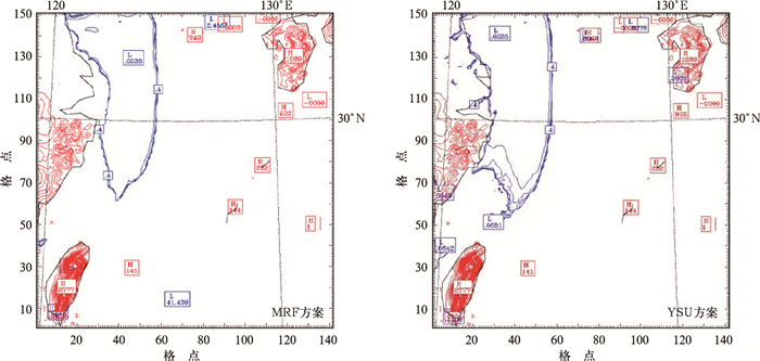
Fig. 1 The visibility simulated by MRF scheme and YSU scheme at 00:00 4 April 2006
(the blue contour denotes the visibility, unit:km; the red contour denotes the terrain, unit:m)

Fig. 2 The ground observation at 00:00 4 April 2006
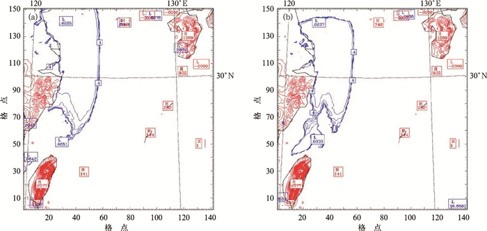
Fig. 3 The visibility simulated in the control experiment (a) and assimilation experiment (b) at 00:00 4 April 2006 (the blue contour denotes the visibility, unit: km; the red contour denotes the terrain, unit: m)

Fig. 4 Wind field at 10 m height (vector) and temperature field at 2 m height (contour, unit:℃) of the control experiment (a) and assimilation experiment (b) at 00:00 4 April 2006

Fig. 5 Relative humidity at 1000 hPa in the control experiment (a) and assimilation experiment (b) at 00:00 4 April 2006 (unit:%)

Fig. 6 The potential height (red contour, unit:m) and temperature (blue contour, unit: K) fields at 850 hPa of the control experiment (a) and assimilation experiment (b) at 00:00 4 April 2006
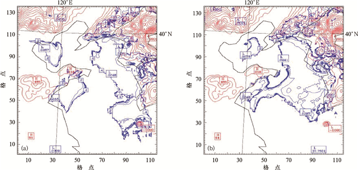
Fig. 7 The simulated visibility of the control experiment (a) and assimilation experiment (b) at 09:00 23 June 2005
(the blue contour denotes the visibility, unit: km; the red contour denotes the terrain, unit:m)

Fig. 8 The ground observation at 09:00 23 June 2005

Fig. 9 Wind field at 10 m height (vector) and temperature field at 2 m height (contour, unit:℃) of the control experiment (a) and assimilation experiment (b) at 09:00 23 June 2005

Fig. 10 Dew point deficit at 1000 hPa of the control experiment (a) and assimilation experiment (b) at 09:00 23 June 2005 (unit:℃)
| [1] |
Leidner S M, Isaksen L, Hoffman R N. Impact of NSCAT winds on tropical cyclones in the ECMWF 4DVAR Assimilation System. Mon Wea Rev, 2003, 131:3-26. doi: 10.1175/1520-0493(2003)131<0003:IONWOT>2.0.CO;2
|
| [2] |
刘春霞, 王静, 齐义泉, 等.基于WRF模式同化QuikSCAT风场资料的初步试验.热带海洋学报, 2004, 23(6):69-74. http://www.cnki.com.cn/Article/CJFDTOTAL-RDHY200406006.htm
|
| [3] |
Zeng Zhihua, Duan Yihong, Liang Xudong, et al. The effect of three-dimensional variational data assimilation of QuikSCAT data on the numerical simulation of typhoon track and intensity. Adv Atm Sci, 2005, 22(4): 534-544. doi: 10.1007/BF02918486
|
| [4] |
樊琦, 王安宇, 范绍佳.珠江三角洲地区一次辐射雾的数值模拟研究.气象科学, 2004, 24(1):1-7. http://www.cnki.com.cn/Article/CJFDTOTAL-QXKX200401000.htm
|
| [5] |
樊琦, 吴兑, 范绍佳, 等.广州地区冬季一次大雾的三维数值模拟研究.中山大学学报, 2003, 42(1):83-86. http://www.cnki.com.cn/Article/CJFDTOTAL-ZSDZ200301021.htm
|
| [6] |
Pagowski M, Gultepe I, King P. Analysis and modeling of an extremely dense fog event in Southern Ontario. J Appl Meteor, 2004, 43:3-16. doi: 10.1175/1520-0450(2004)043<0003:AAMOAE>2.0.CO;2
|
| [7] |
傅刚, 张涛, 周发琇.一次黄海海雾的三维数值模拟研究.青岛海洋大学学报, 2002, 32(6):859-867. http://www.cnki.com.cn/Article/CJFDTOTAL-QDHY200206001.htm
|
| [8] |
傅刚, 王菁茜.一次黄海海雾事件的观测和数值模拟研究.中国海洋大学学报, 2004, 34(5):720-726. http://www.cnki.com.cn/Article/CJFDTOTAL-QDHY200405005.htm
|
| [9] |
Stoelinga M T, Warner T T. Nonhydrostatic, mesobeta-scale model simulations of cloud ceiling and visibility for an East Coast winter precipitation event. Appl Meteor, 1999, 38: 385-404. doi: 10.1175/1520-0450(1999)038<0385:NMSMSO>2.0.CO;2
|
| [10] |
刘宇迪, 亓晨.散射计海面风场的二维变分模糊去除方法.热带气象学报, 2010, 26(5):620-625. http://www.cnki.com.cn/Article/CJFDTOTAL-RDQX201005015.htm
|
| [11] |
Stoffelen A, Anderson D. The ECMWF Contribution to the Characterization, Interpretation, Calibration and Validation of ERS-1 Scatterometer Backscatter Measurements and Their Use in Numerical Weather Prediction Models', ESA Contract 9097/90/NL/BI Report, Eur Centre for Medium-range Weather Forecasts, Reading, England, 1995.
|
| [12] |
石红艳, 王洪芳, 齐琳琳, 等.长江中下游地区一次辐射雾的数值模拟.解放军理工大学学报 (自然科学版), 2005, 6(4):404-408. http://www.cnki.com.cn/Article/CJFDTOTAL-JFJL200504022.htm
|
| [13] |
董剑希. 雾的数值模拟研究及其综合观测. 南京: 南京信息工程大学, 2005.
|
| [14] |
何立富, 李峰, 李泽椿, 等.华北平原一次持续性大雾过程的动力和热力特征.应用气象学报, 2006, 17(2):160-168. http://qikan.camscma.cn/jams/ch/reader/view_abstract.aspx?file_no=20060228&flag=1
|
| [15] |
刘小宁, 张洪政, 李庆祥, 等.我国大雾的气候特征及变化初步解释.应用气象学报, 2005, 16(2):220-230. http://qikan.camscma.cn/jams/ch/reader/view_abstract.aspx?file_no=20050227&flag=1
|
| [16] |
周梅, 银燕, 王巍巍. 2006年12月24—27日大范围大雾过程数值模拟.应用气象学报, 2008, 19(5):602-610. http://qikan.camscma.cn/jams/ch/reader/view_abstract.aspx?file_no=20080512&flag=1
|
| [17] |
刘宇迪, 桂祈军, 李昕东, 等.水平网格计算频散性的研究.应用气象学报, 2001, 12(2):140-149. http://qikan.camscma.cn/jams/ch/reader/view_abstract.aspx?file_no=20010220&flag=1
|
| [18] |
刘宇迪, 朱红伟.垂直网格计算频散性的研究.应用气象学报, 2001, 12(3):348-357. http://qikan.camscma.cn/jams/ch/reader/view_abstract.aspx?file_no=20010346&flag=1
|

Figures(10)

 DownLoad: