
| 参数 | 参数值 |
| 飞行高度 | 约9 km |
| 工作频率 | 35.5 GHz |
| 天线尺寸 | 1.4 m×0.8 m |
| 波束宽度 | 0.9° |
| 采样点数 | 80 |
| 扫描角度 | ±18° |
| 测绘带宽 | 约5.8 km |
| 脉冲宽度 | 20 μs,2.33 μs,1.2 μs |
| 距离分辨率 | 200 m,350 m,180 m |
| 水平分辨率 | 140 m |
| Citation: | Shang Jian, Guo Yang, Wu Qiong, et al. Airborne field campaign results of Ka-band precipitation measuring radar in China. J Appl Meteor Sci, 2011, 22(5): 590-596.

|
Spaceborne precipitation measuring radar can measure precipitation quantitatively, observe the vertical distribution and provide three dimensional precipitation structures. Spaceborne precipitation measuring radar is an important instrument on FY-3 meteorological satellite constellation. As a possible future member of the Global Precipitation Measurement (GPM), this satellite will carry dual-frequency precipitation radar operating at Ku and Ka bands to provide scientific data for dual-frequency retrieval algorithm. Its two prototype devices, Ku-band and Ka-band radars have already been developed under the support of National Defense Science and Industry Bureau. Field campaign of Ku/Ka-band airborne precipitation measuring radar is carried out by National Satellite Meteorological Center of China Meteorological Administration combining several groups from June to October in 2010 in Tianjin and Jiangsu, called BH-RM 2010 and JS-RM 2010, respectively. This is the first time that China carries out airborne precipitation measuring radar field campaign. The purposes of this field campaign are to validate the correctness of internal and external calibration scheme under airborne conditions, observe simultaneously with ground-based radar and microwave radiometer and compare satellite-airplane-ground observation data, validate the functionality and performance of precipitation measuring radar, and explore data processing and retrieval algorithms of precipitation measuring radar. Numerous data are obtained from various instruments in the field campaign, including airborne precipitation measuring radar, ground-based weather radar, ground-based multi-channel microwave radiometer, GPS radiosonde, 10 GHz and 37 GHz radiometer, portable wind measuring device, and temperature measuring device. Initial analysis is accomplished with observation data obtained from BH-RM 2010. Observation results of Ka-band precipitation measuring radar working in pulse compression mode and short pulse mode are presented, which show clearly the vertical and horizontal structure of rainfall. Due to the radar different scan modes, resolutions, frequencies, and dynamic range, it's difficult to compare airborne radar data and ground-based radar data accurately, and the unstable attitude of the airplane makes the comparison more difficult. Spatial matching of Ka-band airborne radar data and Tianjin S-band ground-based Doppler radar data is carried out and detailed procedures are introduced. Quantitative indexes are further computed to indicate the observation consistency statistically. In rain retrieval algorithms, attenuation correction is a critical step. Using GPS radiosonde data, ground-based multi-channel microwave radiometer data and microwave radiative transfer model, the integrated attenuation of Ka-band radar is computed and attenuation correction is accomplished. The result is reasonable, which lays a basis for future rain retrieval. Data obtained by various instruments in the field campaign will be analyzed thoroughly, propelling development and rain rate retrieval of our spaceborne precipitation measuring radar.
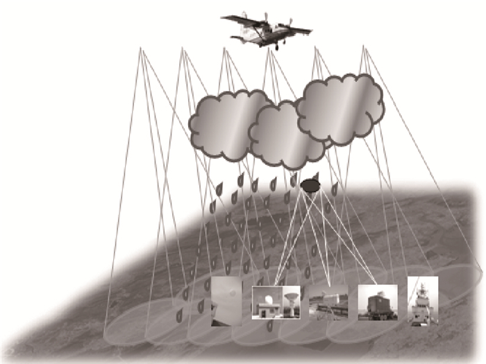
Fig. 1 Diagram of airborne radar and ground simultaneous observations
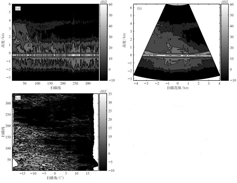
Fig. 2 Measurements of Ka-band radar on 10 July 2010
(pulse compression mode) (a) along-track section, (b) cross-track section, (c) horizontal section
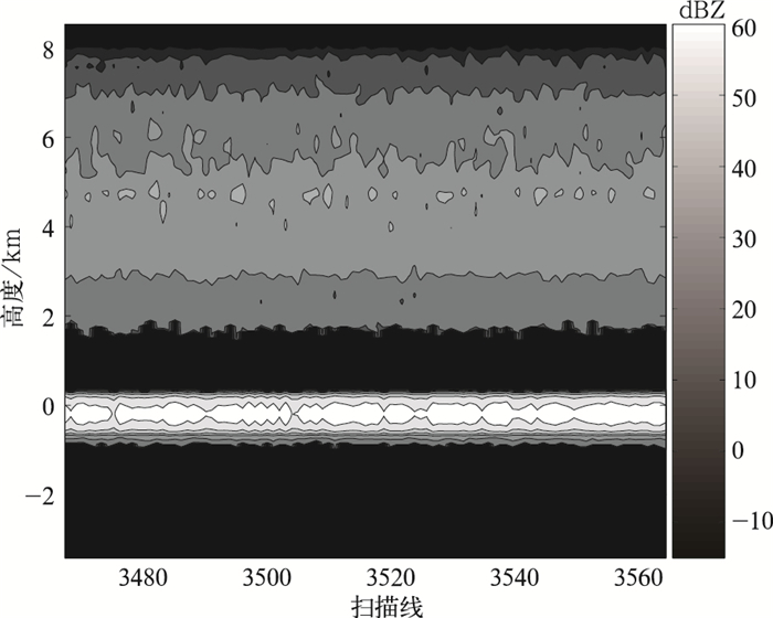
Fig. 3 Measurement of Ka-band radar on 5 August 2010
(short pulse mode)
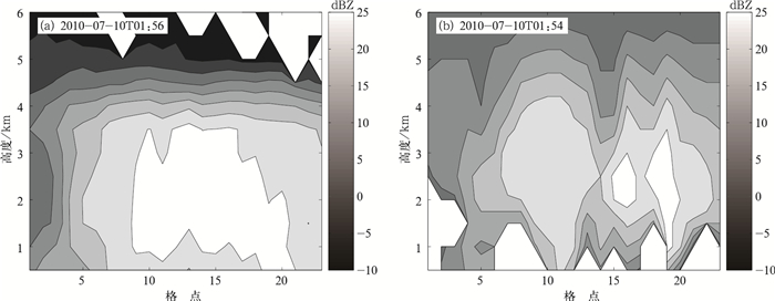
Fig. 4 Vertical profiles of Ka-band radar (a) and S-band radar (b)
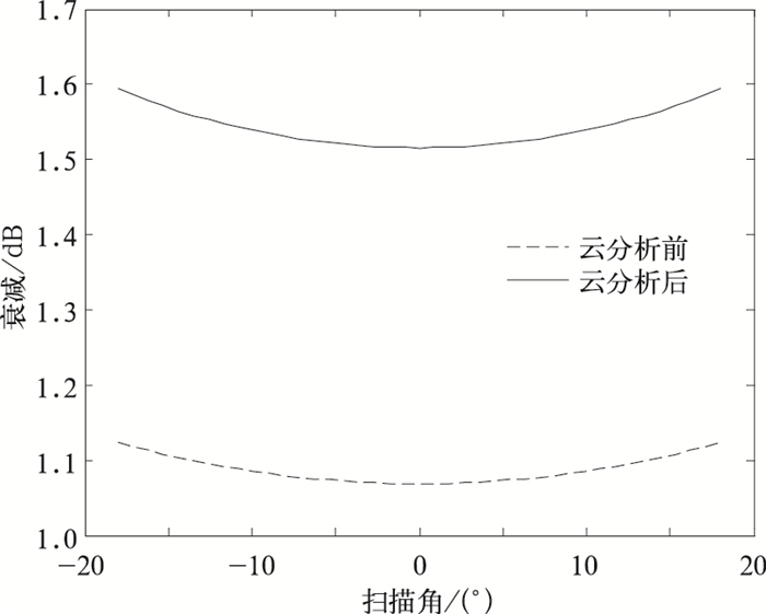
Fig. 5 Ka radar PIA vs scan angle
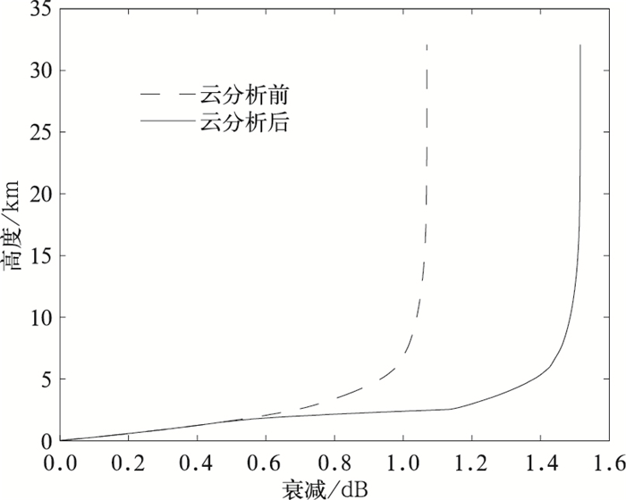
Fig. 6 Ka radar PIA vs height at nadir
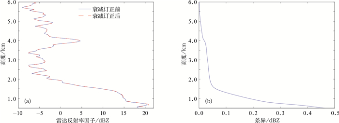
Fig. 7 Attenuation correction result of Ka-band precipitation measuring radar
(a) nadir profiles of reflectivity factors, (b) difference caused by attenuation
Table 1 Main parameters of Ka-band airborne precipitation measuring radar
| 参数 | 参数值 |
| 飞行高度 | 约9 km |
| 工作频率 | 35.5 GHz |
| 天线尺寸 | 1.4 m×0.8 m |
| 波束宽度 | 0.9° |
| 采样点数 | 80 |
| 扫描角度 | ±18° |
| 测绘带宽 | 约5.8 km |
| 脉冲宽度 | 20 μs,2.33 μs,1.2 μs |
| 距离分辨率 | 200 m,350 m,180 m |
| 水平分辨率 | 140 m |
 DownLoad: Download CSV
Table 2 Indexes of match data
| 统计量 | 2010-07-10 | 2010-07-10 | 2010-08-05 | |||
| Ka雷达 | SA雷达 | Ka雷达 | SA雷达 | Ka雷达 | SA雷达 | |
| 观测时间 | 01:56 | 01:54 | 02:21 | 02:24 | 01:53 | 01:54 |
| 最大值/dBZ | 29.0555 | 28.0000 | 26.1907 | 26.0000 | 28.9097 | 16.0000 |
| 最小值/dBZ | -9.3367 | -3.0000 | -8.8639 | -4.0000 | 1.0491 | 1.0000 |
| 平均值/dBZ | 21.3517 | 16.4537 | 15.5933 | 11.6657 | 21.7788 | 11.9742 |
| 均方根误差/dBZ | 9.5053 | 8.1828 | 9.1133 | |||
DownLoad: Download CSV
| [1] |
李锐. TRMM测雨雷达对热带降水结构特征及被动微波反演降水的研究. 合肥: 中国科学技术大学, 2005.
|
| [2] |
王成刚. TRMM PR降水探测及天气雷达降水量估测的方法研究. 南京: 南京大学, 2003.
|
| [3] |
毛冬艳. TRMM资料对中国暴雨个例的分析和降水反演. 北京: 中国气象科学研究院, 2001.
|
| [4] |
刘万栓. 空基雷达测雨衰减算法研究及雨滴谱参数订正. 合肥: 中国科学技术大学, 2000.
|
| [5] |
王连仲. 降雨反演中两种新算法的优化及机载和星载测雨雷达资料的对比验证. 合肥: 中国科学技术大学, 2005.
|
| [6] |
Nakamura K, Okamoto K, Ihara T, et al. Conceptual design of rain radar for the tropical rainfall measuring mission. Int J Sat Commun, 1990, 8(3):257-268. doi: 10.1002/(ISSN)1099-1247
|
| [7] |
刘锦丽, 窦贤康, 张凌, 等.降水分布的空基遥感.遥感技术与应用, 1999, 14(4):1-9. doi: 10.11873/j.issn.1004-0323.1999.4.1
|
| [8] |
傅云飞, 宇如聪, 徐幼平, 等. TRMM测雨雷达和微波成像仪对两个中尺度特大暴雨降水结构的观测分析研究.气象学报, 2003, 61(4):421-431. doi: 10.11676/qxxb2003.041
|
| [9] |
李万彪, 陈勇.利用热带降雨测量卫星的微波成像仪观测资料反演陆地降水.气象学报, 2001, 59(5):591-601. doi: 10.11676/qxxb2001.063
|
| [10] |
Chiu L, Serafino G, Teng W. Applications of tropical rainfall measuring mission (TRMM) Data. IGARSS, 2001, 7:2118-2120. http://ieeexplore.ieee.org/articleDetails.jsp?arnumber=977922
|
| [11] |
Chiu L, Liu Z, Rui H, et al. Tropical Rainfall Measuring Mission Data and Access Tools//Qu J, Gao W, Kafatos M, et al. Earth Science Satellite Remote Sensing, Springer Berlin Heidelberg, 2006:202-219.
|
| [12] |
商建. 空间云雨测量雷达算法及系统技术研究. 北京: 中国科学院电子学研究所, 2009.
|
| [13] |
游然, 卢乃锰, 邱红, 等.用PR资料分析热带气旋卡特里娜降水特征.应用气象学报, 2011, 22(2):203-213. doi: 10.11898/1001-7313.20110209
|
| [14] |
吴庆梅, 程明虎, 苗春生.用TRMM资料研究江淮、华南降水的微波特性.应用气象学报, 2003, 14(2):206-214. http://qikan.camscma.cn/jams/ch/reader/view_abstract.aspx?file_no=20030225&flag=1
|
| [15] |
刘黎平, 葛润生.中国气象科学研究院雷达气象研究50年.应用气象学报, 2006, 17(6):682-689. doi: 10.11898/1001-7313.20060606
|
| [16] |
梁海河, 张沛源, 牛昉, 等.全国天气雷达数据处理系统.应用气象学报, 2002, 13(6):749-754. http://qikan.camscma.cn/jams/ch/reader/view_abstract.aspx?file_no=20020698&flag=1
|
| [17] |
徐广阔, 孙建华, 雷霆, 等.多普勒天气雷达资料同化对暴雨模拟的影响.应用气象学报, 2009, 20(1):36-46. doi: 10.11898/1001-7313.20090105
|
| [18] |
Radiometrics Corporation. TP-WVP3000 Users Manual. http://radiometrics.com, 2005.
|
| [19] |
Bolen S M, Chandrasekar V. Ground and satellite-based radar observation comparisons: Propagation of space-based radar signals. IGARSS, 2000, 3:1352-1354. https://www.researchgate.net/publication/3856026_Ground_and_satellite-based_radar_observation_comparisons_propagation_of_space-based_radar_signals
|
| [20] |
Heymsfield G, Ghosh K, Chen L. An interactive system for compositing digital radar and satellite data. J Climate Appl Meteor, 1983, 22(5):705-713. doi: 10.1175/1520-0450(1983)022<0705:AISFCD>2.0.CO;2
|

Figures(7) / Tables(2)
