Bian Jie, Li Shuanglin, He Jinhai. Risk assessment of flood disaster in the Mid-lower Reaches of the Yangtze. J Appl Meteor Sci, 2011, 22(5): 604-611.
Citation: Bian Jie, Li Shuanglin, He Jinhai. Risk assessment of flood disaster in the Mid-lower Reaches of the Yangtze. J Appl Meteor Sci, 2011, 22(5): 604-611.

Risk Assessment of Flood Disaster in the Mid-lower Reaches of the Yangtze

  • Received Date: 2010-11-29
  • Rev Recd Date: 2011-06-24
  • Publish Date: 2011-10-31
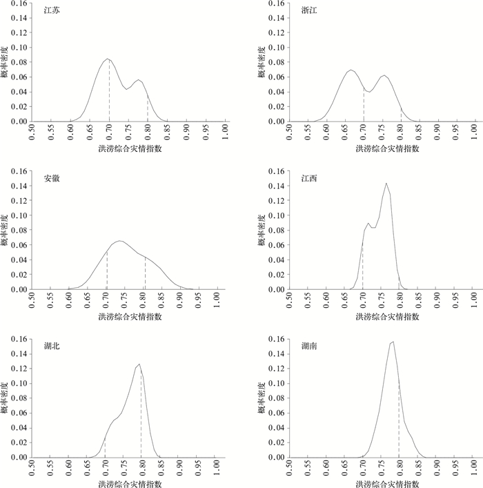
  • Flood disasters caused by heavy rain events occur frequently in the mid-lower reaches of the Yangtze in monsoonal rainy season. The risk of heavy rain events is an important topic in meteorological research in China. Therefore, risk rank of flood disaster in six provinces in the mid-lower reaches of the Yangtze (Hubei, Hunan, Anhui, Jiangxi, Jiangsu and Zhejiang) are assessed based on most recently updated meteorological disaster losses dataset collected by the Ministry of Civil Affairs, National Disaster Reduction Centre of China from 2000 to 2008.First, losses due to flood disasters are classified and quantified by using the method of grey association analysis. The results show that the grey association method is reasonable in disaster situation grading and loss ranking, and the results are basically in agreement with the actual situation. Then an integrated index series in the recent 9 years is established. In addition, the model is very practical and flexible because the numbers of the grade indexes are not limited. Second, since there are not enough integrated historical disaster indexes, an information diffusion based fuzzy method is introduced to optimize the historical disaster data and then the risk in each province is assessed individually. The risk rank results show substantial difference in these provinces. Although medium risk is universal in all the provinces with the occurrence probability of once in one to two years, high risk is relatively more frequent in three provinces, Anhui, Hubei and Hunan, which approximately tallies with the practical situation. This also suggests an efficiency of the present risk-assessment model in processing inadequately long records and deserves extensive use.
  • Fig. 1  The probability density curve of synthetic disaster index in the mid-lower Reaches of the Yangtze

    Table  1  Flood grades and standard of classification for individual index

    灾害等级 受灾人口/人 农作物受灾面积/hm2 直接经济损失/元
    巨灾 (1×10⁷,+∞) (6.667×10⁶,+∞) (1×10¹⁰,+∞)
    大灾 (1×106,1×107) (6.667×105,6.667×106) (1×109,1×1010)
    中灾 (1×105,1×106) (6.667×104,6.667×105) (1×108,1×109)
    小灾 (1×104,1×105) (6.667×103,6.667×104) (1×107,1×108)
    微灾 (1×103,1×104) (6.667×102,6.667×103) (1×106,1×107)
    DownLoad: Download CSV

    Table  2  The relationship between individual conversion function and flood grades

    灾情等级 转换函数值
    巨灾 0.8~1
    大灾 0.6~0.8
    中灾 0.4~0.6
    小灾 0.2~0.4
    微灾 0~0.2
    DownLoad: Download CSV

    Table  3  The corresponding relationship between the correlation degree and flood grades

    灾害等级 关联度
    巨灾 0.9~1
    大灾 0.8~0.9
    中灾 0.7~0.8
    小灾 0.6~0.7
    微灾 0.5~0.6
    DownLoad: Download CSV

    Table  4  The synthetic disaster index and afflicted grades for flood disaster of each province

    年份 江苏 浙江 安徽 江西 湖北 湖南
    灾情指数 灾害
    等级
    灾情指数 灾害
    等级
    灾情指数 灾害
    等级
    灾情指数 灾害
    等级
    灾情指数 灾害
    等级
    灾情指数 灾害
    等级
    2000 0.7802 中灾 0.7779 中灾 0.7299 中灾 0.7447 中灾 0.7599 中灾 0.7447 中灾
    2001 0.7159 中灾 0.7519 中灾 0.6867 小灾 0.7140 中灾 0.7366 中灾 0.7642 中灾
    2002 0.7225 中灾 0.7676 中灾 0.7703 中灾 0.7799 中灾 0.7959 中灾 0.8323 大灾
    2003 0.7107 中灾 0.6855 小灾 0.8517 大灾 0.7735 中灾 0.8090 大灾 0.7947 中灾
    2004 0.6806 小灾 0.6403 小灾 0.7059 中灾 0.7300 中灾 0.7718 中灾 0.7890 中灾
    2005 0.6687 小灾 0.6775 小灾 0.8009 大灾 0.7659 中灾 0.7854 中灾 0.7799 中灾
    2006 0.7928 中灾 0.6809 小灾 0.7480 中灾 0.7579 中灾 0.7165 中灾 0.7898 中灾
    2007 0.7720 中灾 0.6490 小灾 0.8194 大灾 0.7108 中灾 0.8040 大灾 0.7729 中灾
    2008 0.6900 小灾 0.7427 中灾 0.7444 中灾 0.7815 中灾 0.8053 大灾 0.7977 中灾
    DownLoad: Download CSV

    Table  5  The risk level of six provinces in the mid-lower Reaches of the Yangtze

    省份 巨灾 大灾 中灾 小灾 微灾
    江苏 0 0.0537 0.5583 0.3878 0.0002
    浙江 0 0.0238 0.4675 0.4964 0.0123
    安徽 0.004 0.2455 0.5736 0.1765 0.0003
    江西 0 0.0059 0.9307 0.0633 0
    湖北 0 0.2226 0.7480 0.0294 0
    湖南 0 0.2123 0.7871 0.0005 0
    DownLoad: Download CSV

    Table  6  The flooding frequency of each province along the mid-lower Reaches of the Yangtze during 2000—2008

    省份 巨灾 大灾 中灾 小灾 微灾
    江苏 0 0 0.67 0.33 0
    浙江 0 0 0.44 0.56 0
    安徽 0 0.33 0.56 0.11 0
    江西 0 0 1.00 0 0
    湖北 0 0.33 0.67 0 0
    湖南 0 0.11 0.89 0 0
    DownLoad: Download CSV
  • [1]
    周自江, 宋连春, 李小泉.1998年长江流域特大洪水的降水分析.应用气象学报, 2000, 11(3):287-296. http://qikan.camscma.cn/jams/ch/reader/view_abstract.aspx?file_no=20000344&flag=1
    [2]
    薛秋芳, 任传森, 陶诗言.1998年长江流域洪涝的成因分析.应用气象学报, 2001, 12(2):245-250. http://qikan.camscma.cn/jams/ch/reader/view_abstract.aspx?file_no=20010233&flag=1
    [3]
    张顺利, 陶诗言, 张庆云, 等. 1998年中国暴雨洪涝灾害的气象水文特征.应用气象学报, 2001, 12(4):442-457. http://qikan.camscma.cn/jams/ch/reader/view_abstract.aspx?file_no=20010459&flag=1
    [4]
    谢安, 毛江玉, 宋焱云, 等.长江中下游地区水汽输送的气候特征.应用气象学报, 2002, 13(1):67-77. http://qikan.camscma.cn/jams/ch/reader/view_abstract.aspx?file_no=20020108&flag=1
    [5]
    李峰, 何立富.长江中下游地区夏季旱涝年际、年代际变化的可能成因研究.应用气象学报, 2002, 13(6):718-726. http://qikan.camscma.cn/jams/ch/reader/view_abstract.aspx?file_no=20020694&flag=1
    [6]
    黄崇福, 王家鼎.模糊信息优化处理技术及其应用.北京:北京航天航空大学出版社, 1995.
    [7]
    刘立新, 黄崇福, 史培军.对不完备样本下风险分析方法的改进及应用——以湖南省农村种植业水灾为例.自然灾害学报, 1998, 7(2):10-16. http://www.cnki.com.cn/Article/CJFDTOTAL-ZRZH802.001.htm
    [8]
    王新洲, 游扬声.论信息扩散估计的窗宽.测绘科学, 2001, 26(1):16-19. http://www.cnki.com.cn/Article/CJFDTOTAL-CHKD200101003.htm
    [9]
    王新洲, 游扬声, 汤永净.最优信息扩散估计理论及其应用.地理空间信息, 2003, 1(1):10-21. http://www.cnki.com.cn/Article/CJFDTOTAL-DXKJ200301005.htm
    [10]
    李梅, 张洪波, 黄强, 等.基于信息扩散估计的洪水风险分析.中北大学学报 (自然科学版), 2007, 28(3):193-198. http://www.cnki.com.cn/Article/CJFDTOTAL-HBGG200703001.htm
    [11]
    黄崇福, 刘立新, 周国贤, 等.以历史灾情资料为依据的农业自然灾害风险评估方法.自然灾害学报, 1998, 7(2):1-9. http://www.cnki.com.cn/Article/CJFDTOTAL-ZRZH802.000.htm
    [12]
    刘引鸽, 缪启龙, 高庆九.基于信息扩散理论的气象灾害风险评价方法.气象科学, 2005, 25(1):84-89. http://www.cnki.com.cn/Article/CJFDTOTAL-QXKX20050100B.htm
    [13]
    杜晓燕, 黄岁樑, 赵庆香.基于信息扩散理论的天津旱涝灾害危险性评估.灾害学, 2009, 24(1):22-25. http://www.cnki.com.cn/Article/CJFDTOTAL-ZHXU200901004.htm
    [14]
    刘家福, 梁雨华.基于信息扩散理论的洪水灾害风险分析.吉林师范大学学报:自然科学版, 2009, 3:78-80. http://www.cnki.com.cn/Article/CJFDTOTAL-SLXK200903020.htm
    [15]
    Huang Chongfu. Principle of information diffusion. Fuzzy Sets and Systems, 1997, 91:69-90. doi:  10.1016/S0165-0114(96)00257-6
    [16]
    刘立新.区域水灾风险评估的理论与实践.北京:北京大学出版社, 2005.
    [17]
    马宗晋, 杨华庭, 高建国, 等.我国自然灾害的经济特征与社会发展.科技导报, 1994, 7:61-64. http://www.cnki.com.cn/Article/CJFDTOTAL-KJDB407.021.htm
    [18]
    于庆东, 沈荣芳.自然灾害绝对灾情分级模型及应用.系统工程理论方法应用, 1995, 4(3):47-52. http://www.cnki.com.cn/Article/CJFDTOTAL-XTGL503.008.htm
    [19]
    杨仕升.自然灾害等级划分及灾情比较模型探讨.自然灾害学报, 1997, 6(1): 8-13. http://www.cnki.com.cn/Article/CJFDTOTAL-ZRZH701.001.htm
    [20]
    刘燕华, 李钜章, 赵跃龙.中国近期自然灾害程度的区域特征.地理研究, 1995, 14(3):14-25. http://www.cnki.com.cn/Article/CJFDTOTAL-DLYJ503.001.htm
    [21]
    冯利华.灾害损失的定量计算.灾害学, 1993, 8(2): 17-19. http://www.cnki.com.cn/Article/CJFDTOTAL-ZHXU199302003.htm
    [22]
    傅立.灰色系统理论及其应用.北京:科学出版社, 1992: 191-199.
  • 加载中
  • -->

Catalog

    Figures(1)  / Tables(6)

    Article views (4276) PDF downloads(1868) Cited by()
    • Received : 2010-11-29
    • Accepted : 2011-06-24
    • Published : 2011-10-31

    /

    DownLoad:  Full-Size Img  PowerPoint