
| 日期 | 像元陆表温度/K | 0 cm陆表温度平均/K | 误差/K |
| 2010-08-14 | 316.30 | 316.13 | -0.17 |
| 2010-08-24 | 316.70 | 318.47 | 1.77 |
| Citation: | Dong Lixin, Yang Hu, Zhang Peng, et al. Retrieval of land surface temperature and dynamic monitoring of a high temperature weather process based on FY-3A/VIRR data. J Appl Meteor Sci, 2012, 23(2): 214-222.

|

Fig. 1 Scatter plot of LST from FY-3A/VIRR and that from MODIS-TERRA on 24 May 2010
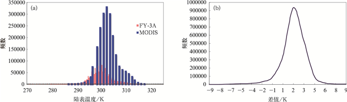
Fig. 2 Comparison between LST products from FY-3A/VIRR and those from MODIS-TERRA
(a) distribution of frequency, (b) distribtuion of difference frequency
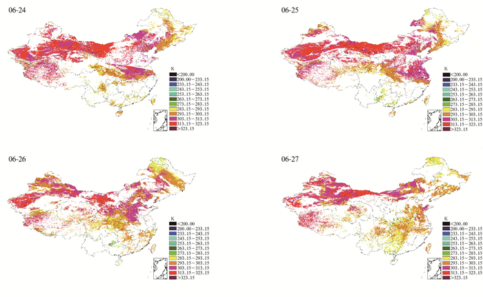
Fig. 3 The first high-temperature process in the latter half of Jun in 2009 by FY-3A/VIRR LST
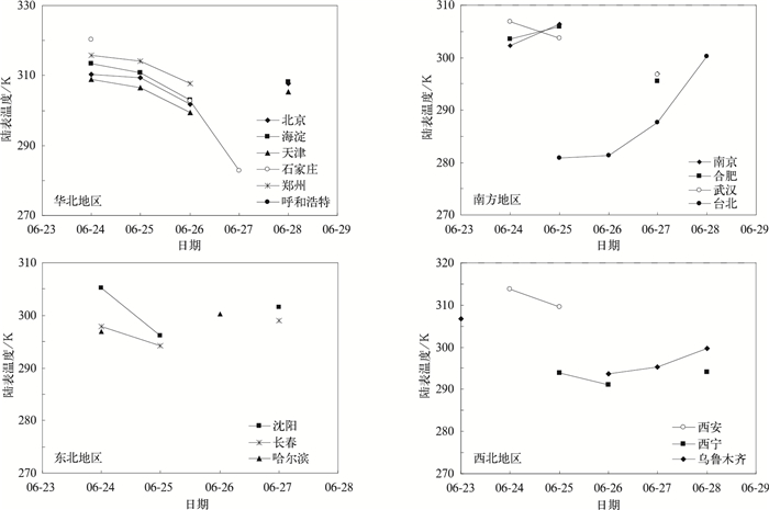
Fig. 4 Changes of FY-3A/VIRR LST among mainly cities in China in Jun 2009

Fig. 5 The profile of FY-3A/VIRR LST and analysis of surface status (images, 5 km×5 km) in Beijing and Shijiazhuang
Table 1 Synchronization validation between satellite and the earth for FY-3A LST
| 日期 | 像元陆表温度/K | 0 cm陆表温度平均/K | 误差/K |
| 2010-08-14 | 316.30 | 316.13 | -0.17 |
| 2010-08-24 | 316.70 | 318.47 | 1.77 |
 DownLoad: Download CSV
| [1] |
Gruza G, Rankova E, Razuvaev V. Indicators of climate change for the Russian federation. Climatic Change, 1999, 42:219-242. doi: 10.1023/A:1005480719118
|
| [2] |
王鹏祥, 杨金虎.中国西北近45a来极端高温事件及其对区域性增暖的响应.中国沙漠, 2007, 27(4):649-655. http://www.cnki.com.cn/Article/CJFDTOTAL-ZGSS200704020.htm
|
| [3] |
马柱国, 符宗斌, 任小波, 等.中国北方年极端温度的变化趋势与区域增暖的联系.地理学报, 2003, 58(增刊):11-20. http://www.cnki.com.cn/Article/CJFDTOTAL-DLXB2003S1001.htm
|
| [4] |
翟盘茂, 潘晓华.中国北方近50a温度和降水极端事件变化.地理学报, 2003, 58(增刊):1-10. http://www.cnki.com.cn/Article/CJFDTOTAL-DLXB2003S1000.htm
|
| [5] |
龚志强, 王晓娟, 支蓉, 等.中国近58年温度极端事件的区域特征及其与气候突变的联系.物理学报, 2009, 58(6):4342-4353. doi: 10.7498/aps.58.4342
|
| [6] |
Meehl G A, Karl T, Easterling D R, et al. An introduction to trends in extreme weather and climate events: Observations, socioeconomic impacts, terrestrial ecological impacts, and model projections. Bull Amer Meteor Soc, 2000, 81(3):413-416. doi: 10.1175/1520-0477(2000)081<0413:AITTIE>2.3.CO;2
|
| [7] |
Easterling D R, Evans J L, Groisman P Y, et al. Observed variability and trends in extreme climate events: A brief review. Bull Amer Meteor Soc, 2000, 81(3): 417-425. doi: 10.1175/1520-0477(2000)081<0417:OVATIE>2.3.CO;2
|
| [8] |
黄丹青, 钱永甫.我国极端温度事件的定义和趋势分析.中山大学学报:自然科学版, 2008, 47(3): 112-116. http://www.cnki.com.cn/Article/CJFDTOTAL-ZSDZ200803023.htm
|
| [9] |
李玲萍, 李庆玉, 李岩瑛.河西走廊东部高温天气气候特征分析.干旱地区农业研究, 2009, 27(2):35-40. http://www.cnki.com.cn/Article/CJFDTOTAL-GHDQ200902007.htm
|
| [10] |
卫捷, 孙建华.华北地区夏季高温闷热天气特征的分析.气候与环境研究, 2007, 12 (3):453-463. http://www.cnki.com.cn/Article/CJFDTOTAL-QHYH200703024.htm
|
| [11] |
张尚印, 宋艳玲, 张德宽, 等.华北主要城市夏季高温天气气候特征及评估方法.地理学报, 2004, 59(3):383-390. doi: 10.11821/xb200403008
|
| [12] |
王迎春, 葛国庆, 陶祖钰.北京夏季高温闷热天气的气候特征和2008夏季奥运会.气象, 2003, 29(9):23-27. doi: 10.7519/j.issn.1000-0526.2003.09.005
|
| [13] |
余永江, 郑有飞, 谈建国, 等.近50a来中国大城市体感温度变化.气象科学, 2009, 29(2): 272-276. http://www.cnki.com.cn/Article/CJFDTOTAL-QXKX200902020.htm
|
| [14] |
王明星.大气化学 (第二版).北京:气象出版社, 1999.
|
| [15] |
周淑贞, 束炯.城市气候学.北京:气象出版社, 1994.
|
| [16] |
张光智, 徐祥德, 王继志, 等.北京及周边地区城市尺度热岛特征及其演变.应用气象学报, 2002, 13(特刊): 41-49. http://www.cnki.com.cn/Article/CJFDTOTAL-YYQX2002S1004.htm
|
| [17] |
侯依玲, 陈葆德, 陈伯民, 等.上海城市化进程导致的局地气温变化特征.高原气象, 2008, 27(增刊):131-137. http://www.cnki.com.cn/Article/CJFDTOTAL-GYQX2008S1017.htm
|
| [18] |
郭维栋, 孙菽芬.土壤热异常对地表能量平衡影响初探.气象学报, 2002, 60(6):706-714. doi: 10.11676/qxxb2002.084
|
| [19] |
张慧智, 史学正, 于东升, 等.中国土壤温度的空间插值方法比较.地理研究, 2008, 27(6):1299-1307. http://www.cnki.com.cn/Article/CJFDTOTAL-DLYJ200806009.htm
|
| [20] |
周志恩, 蒋维楣, 胡非, 等.气象卫星观测资料的分析在城市区域气象环境研究中的应用.气象科学, 2003, 23(3):292-299. http://www.cnki.com.cn/Article/CJFDTOTAL-QXKX200303004.htm
|
| [21] |
Dousset B, Gourmelon F. Satellite multi-sensor data analysis of urban surface temperatures and landcover. ISPRS Journal of Photogrammetry & Remote Sensing, 2003, 58: 43-54. http://www.sciencedirect.com/science/article/pii/S0924271603000169
|
| [22] |
Voogt J A, Oke T R. Thermal remote sensing of urban climates. Remote Sens Environ, 2003, 86: 370-384. doi: 10.1016/S0034-4257(03)00079-8
|
| [23] |
宋艳, 余世孝, 李楠, 等.深圳特区表面温度空间分异特征.生态学报, 2007, 27(4):1489-1498. http://www.cnki.com.cn/Article/CJFDTOTAL-STXB200704027.htm
|
| [24] |
丁金才, 张志凯, 奚红, 等.上海地区盛夏高温分布和热岛效应的初步研究.大气科学, 2002, 26(3):412-420. http://www.cnki.com.cn/Article/CJFDTOTAL-DQXK200203011.htm
|
| [25] |
申双和, 赵小艳, 杨沈斌, 等.利用ASTER数据分析南京城市地表温度分布.应用气象学报, 2009, 20(4):458-464. http://qikan.camscma.cn/jams/ch/reader/view_abstract.aspx?file_no=200904010&flag=1
|
| [26] |
吴晓, 陈维英.利用FY-1D极轨气象卫星分裂窗区通道计算陆表温度.应用气象学报, 2005, 16(1): 45-53. http://qikan.camscma.cn/jams/ch/reader/view_abstract.aspx?file_no=20050106&flag=1
|
| [27] |
Kerr Y H, Lagouarde J P, Imberton J, et a1.Accurate land Surface temperature retrieval from AVHRR data with use of an improved split window algorithm. Remote Sensing Environ, 1992, 41:197-209. doi: 10.1016/0034-4257(92)90078-X
|
| [28] |
Wan Z, Dozier J. A generalized split-window algorithm for retrieving land-surface temperature from space. IEEE Transactions on Geoscience and Romete Sensing, 1996, 34(4):892-905. doi: 10.1109/36.508406
|
| [29] |
毛克彪.用MODIS影像和劈窗算法反演山东半岛的地表温度.中国矿业大学学报, 2005(1):47-50. http://www.cnki.com.cn/Article/CJFDTOTAL-ZGKD200501010.htm
|
| [30] |
杨军, 董超华.新一代风云极轨气象卫星业务产品及应用.北京:科学出版社, 2010: 215-217.
|
| [31] |
杨虎, 杨忠东.中国陆地区域陆表温度业务化遥感反演算法及产品运行系统.遥感学报, 2006, 10(4):600-607. doi: 10.11834/jrs.20060488
|
| [32] |
Becker F, Li Z L. Towards a local split window method over land surface. Int J Remote Sens, 1990, 11(3): 369-393. doi: 10.1080/01431169008955028
|
| [33] |
Caselles V, Coll C, Valor E. land surface temperature determination in the whole Hapex Sahel area from AVHRR data. Int J Remote Sensing, 1997, 18(5): 1009-1027. doi: 10.1080/014311697218548
|
| [34] |
Rubio E, Caselles V, Badenas C. Emissivity measurements of several soils and vegetation types in the 8~14 μm wave band: Analysis of two field methods. Remote Sens Environ, 1997, 59(3): 490-521. doi: 10.1016/S0034-4257(96)00123-X
|
| [35] |
Zeng X B, Dickinson R E, Walker A, et al. Derivation and evalustion of global 1-km fractional vegetation cover data for land modeling. J Appl Meteor, 2000, 39(6): 826-839. doi: 10.1175/1520-0450(2000)039<0826:DAEOGK>2.0.CO;2
|
| [36] |
孙亮, 孙睿, 贾成刚, 等. MODIS数据反演陆表温度劈窗算法比较.北京师范大学学报:自然科学版, 2008, 44(4):434-438. http://www.cnki.com.cn/Article/CJFDTOTAL-YGJS201302003.htm
|
| [37] |
唐国利, 任国玉, 周江兴.西南地区城市热岛强度变化对地面气温序列影响.应用气象学报, 2010, 21(6):722-730. http://qikan.camscma.cn/jams/ch/reader/view_abstract.aspx?file_no=20080612&flag=1
|
| [38] |
郑祚芳, 范水勇, 王迎春.城市热岛效应对比北京夏季高温的影响.应用气象学报, 2006, 17(增刊):48-53. http://www.cnki.com.cn/Article/CJFDTotal-YYQX2006S1006.htm
|

Figures(5) / Tables(1)
