
| 试验 | 0~24 h | 24~48 h | ||||
| 降水量/mm | 超过100 mm格点数 | 超过200 mm格点数 | 降水量/mm | 超过100 mm格点数 | 超过200 mm格点数 | |
| CTRL2 | 153.2 | 1142 | 3 | 267.7 | 2297 | 113 |
| SMON | 178.5↑ | 1186↑ | 12↑ | 281.9↑ | 2367↑ | 179↑ |
| WMON | 143.5↓ | 979↓ | 0↓ | 215.8↓ | 1530↓ | 7↓ |
| 注:↑表示增加,↓表示减少。 | ||||||
| Citation: | Cheng Zhengquan, Chen Lianshou, Li Ying. Interaction between landfalling tropical cyclone and summer monsoon with influences on torrential rain. J Appl Meteor Sci, 2012, 23(6): 660-671.

|
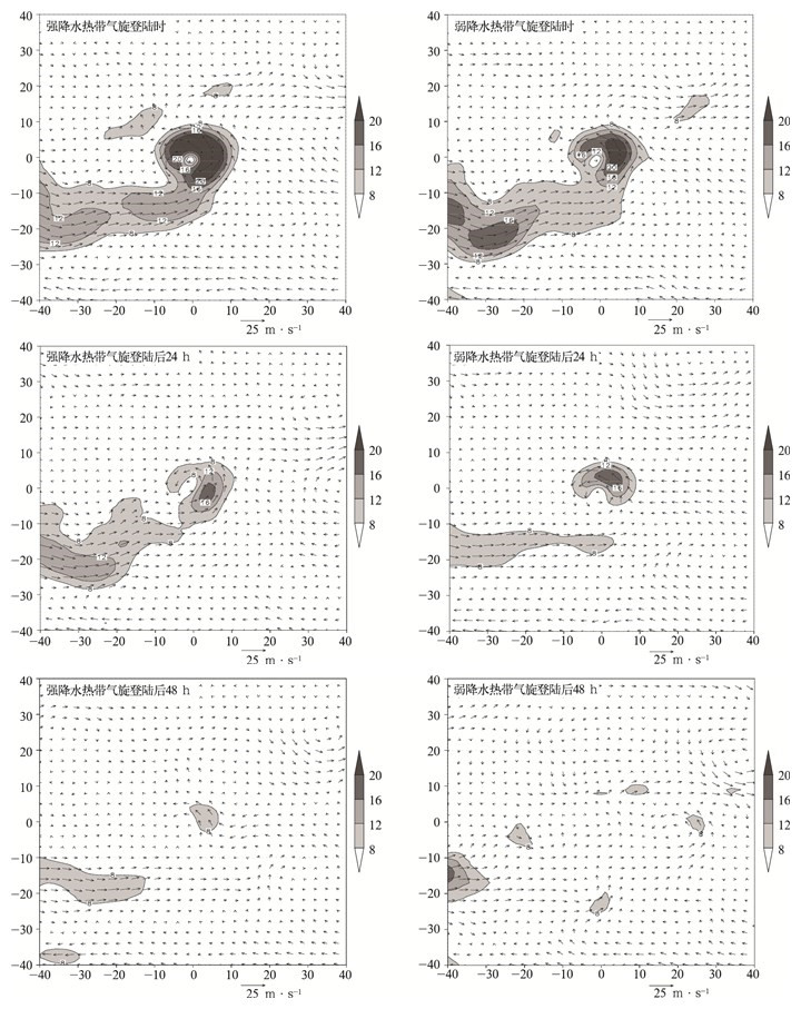
Fig. 1 Composite 850 hPa wind (vector) and water vapor flux (shaded, unit: g·s-1·hPa-1·cm-1) of strong and weak rainfall tropical cyclones
(abscissa represents grid number away from the tropical cyclone center, and negative denotes westwards and southwards; tropical cyclone center is located at coordinate origin and grid space is 1.0°)
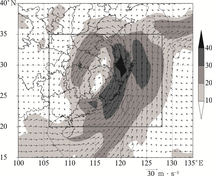
Fig. 2 850 hPa wind (vector, unit:m/s) and water vapor flux (shaded, unit: g·cm-1·hPa-1·s-1) 24 h after Bilis landfalling with its boundary (rectangle)
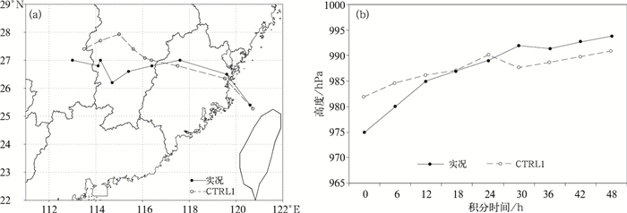
Fig. 3 Observations and simulated track (a) and minimal central SLP (b)
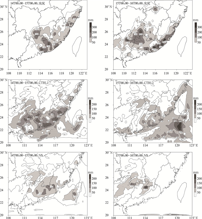
Fig. 4 24 h total rainfall observation and outputs of control and NS sensitivity experiments from 14 July to 16 July in 2006

Fig. 5 850 hPa specific humidity (shaded) and wind (vector) of CTRL1 and NALL experiments
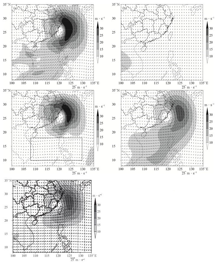
Fig. 6 850 hPa initial winds (a), decomposed large-scale winds (b), decomposed meso-and micro-scale winds and initial winds in SMON (d) and WMON (e) at 0000 UTC 14 Jul 2006

Fig. 7 24 h accumulated rainfall of CTRL2, SMON and WMON
Table 1 Maximal 24 h accumulated rainfall heavy rain grid number in the numerical experiments
| 试验 | 0~24 h | 24~48 h | ||||
| 降水量/mm | 超过100 mm格点数 | 超过200 mm格点数 | 降水量/mm | 超过100 mm格点数 | 超过200 mm格点数 | |
| CTRL2 | 153.2 | 1142 | 3 | 267.7 | 2297 | 113 |
| SMON | 178.5↑ | 1186↑ | 12↑ | 281.9↑ | 2367↑ | 179↑ |
| WMON | 143.5↓ | 979↓ | 0↓ | 215.8↓ | 1530↓ | 7↓ |
| 注:↑表示增加,↓表示减少。 | ||||||
 DownLoad: Download CSV
| [1] |
陶诗言.中国之暴雨.北京:科学出版社, 1980.
|
| [2] |
程正泉, 陈联寿, 彭涛涌, 等. 1960—2003年中国热带气旋降水时空分布特征.应用气象学报, 2007, 18(4):427-434. http://qikan.camscma.cn/jams/ch/reader/view_abstract.aspx?file_no=20070470&flag=1
|
| [3] |
Li Tim, Wang Bin. A review on the western north Pacific monsoon: Synoptic-to-interannual variabilities, terrestrial. Atmospheric and Oceanic Sciences, 2005, 16(2): 285-314. doi: 10.3319/TAO.2005.16.2.285(A)
|
| [4] |
Mark A L. Description of a monsoon Gyre and its effects on the tropical cyclones in the western north Pacific during August 1991. Wea Forecasting, 1994, 9(4): 640-654. doi: 10.1175/1520-0434(1994)009<0640:DOAMGA>2.0.CO;2
|
| [5] |
Chen Tsing-Chang, Weng Shu-Ping, Yamazaki Nubuo, et al. Interannual variation in the tropical cyclone formation over the western north Pacific. Mon Wea Rev, 1998, 126(4): 1080-1090. doi: 10.1175/1520-0493(1998)126<1080:IVITTC>2.0.CO;2
|
| [6] |
陈联寿, 丁一汇.西太平洋台风概论.北京:科学出版社, 1979.
|
| [7] |
李英, 陈联寿, 王继志.登陆热带气旋长久维持与迅速消亡的大尺度环流特征.气象学报, 2004, 62(2):167-179. doi: 10.11676/qxxb2004.018
|
| [8] |
程正泉, 陈联寿, 李英.登陆台风降水的大尺度环流诊断分析.气象学报, 2009, 67(5):840-850. doi: 10.11676/qxxb2009.082
|
| [9] |
丁一汇.高等天气学.北京:气象出版社, 2005.
|
| [10] |
Cheng Zhaohui, Kang Di, Chen Lianshou, et al. Interaction between tropical cyclone and Meiyu front. Acta Meteorologica Sinica, 1999, 13(1):35-46. http://kns.cnki.net/KCMS/detail/detail.aspx?filename=qxxw199901003&dbname=CJFD&dbcode=CJFQ
|
| [11] |
吴恒强.影响广西的热带气旋与热带季风的某些关系.气象, 2002, 28(9): 27-32. doi: 10.7519/j.issn.1000-0526.2002.09.006
|
| [12] |
卢珊, 王黎娟, 管兆勇, 等.低纬季风涌影响登陆台风"榴莲"(0103) 和"碧利斯"(0604) 暴雨增幅的比较.大气科学学报, 2012, 35(2):175-185. http://www.cnki.com.cn/Article/CJFDTOTAL-NJQX201202006.htm
|
| [13] |
黄小玉, 陈江民, 叶成志. "碧利斯"引发湘东南特大暴雨的多普勒雷达回波特征分析.大气科学学报, 2010, 31(1):7-13. http://www.cnki.com.cn/Article/CJFDTOTAL-NJQX201001002.htm
|
| [14] |
叶成志, 李昀英.热带气旋"碧利斯"与南海季风相互作用的强水汽特征数值研究.气象学报, 2011, 69(3):496-507. doi: 10.11676/qxxb2011.043
|
| [15] |
钱传海, 路秀娟, 陈涛.引起"碧利斯"强降水的MCS数值模拟研究.气象, 2009, 35(4):11-19. doi: 10.7519/j.issn.1000-0526.2009.04.002
|
| [16] |
卢咸池, 何斌.初值格谱变换的比较分析.计算物理, 1992, 9(4):768-770. http://www.cnki.com.cn/Article/CJFDTOTAL-JSWL1992S2038.htm
|
| [17] |
孟智勇, 徐祥德, 陈联寿. 9406号台风与中纬度系统相互作用的中尺度特征.气象学报, 2002, 60(1):31-39. doi: 10.11676/qxxb2002.003
|
| [18] |
陈久康, 丁治英.高低空急流与台风环流耦合下的中尺度暴雨系统.应用气象学报, 2000, 11(3):271-281. http://qikan.camscma.cn/jams/ch/reader/view_abstract.aspx?file_no=20000342&flag=1
|
| [19] |
徐文慧, 倪允琪.登陆台风环流内的一次中尺度强对流过程.应用气象学报, 2009, 20(3):267-275. http://qikan.camscma.cn/jams/ch/reader/view_abstract.aspx?file_no=20090302&flag=1
|
| [20] |
Chen Lianshou, Luo Zhexian. Effect of the interaction of different scale vortices on the structure and motion of typhoons. Adv Atmos Sci, 1995, 12(2): 207-214. doi: 10.1007/BF02656833
|
| [21] |
陈联寿.热带气旋研究和业务预报技术的发展.应用气象学报, 2006, 17(6):672-681. http://qikan.camscma.cn/jams/ch/reader/view_abstract.aspx?file_no=200606116&flag=1
|
| [22] |
郭荣芬, 肖子牛, 陈小华, 等.两次西行热带气旋影响云南降水对比分析.应用气象学报, 2010, 21(3):317-328. http://qikan.camscma.cn/jams/ch/reader/view_abstract.aspx?file_no=20100307&flag=1
|

Figures(7) / Tables(1)
