| Citation: | Huang Yong, Qin Danyu. Cumulus merging in the massive mudslide of Zhouqu using meteorological satellite data. J Appl Meteor Sci, 2013, 24(1): 87-98.

|
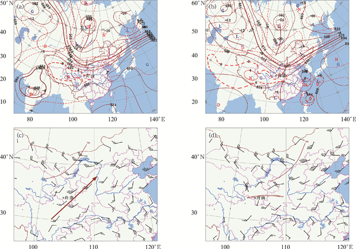
Fig. 1 Synoptic chart at 0000 UTC and 1200 UTC on 7 Aug 2010 (a)500 hPa height (solid line, unit:dagpm) and temperature (dashed line, unit:℃) at 0000 UTC, (b)500 hPa height (solid line, unit: dagpm) and temperature (dashed line, unit:℃) at 1200 UTC, (c)700 hPa wind at 0000 UTC (single curve:trough; arrow:southwestern airflow), (d)700 hPa wind at 1200 UTC (single curve:trough; double curves:shear line)
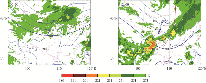
Fig. 2 Satellite image of FY-2E with synoptic analysis at 500 hPa on 7 Aug 2010(unit: dagpm)
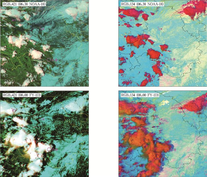
Fig. 3 False color combination image on 7 Aug 2010
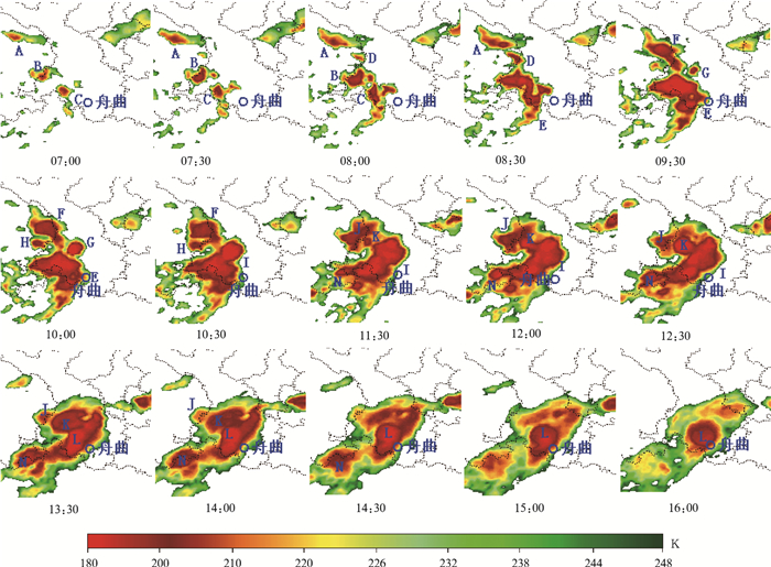
Fig. 4 Enhanced IR image at 0700 UTC—1600 UTC on 7 Aug 2010

Fig. 5 Temporal variety of cloud area and eccentricity
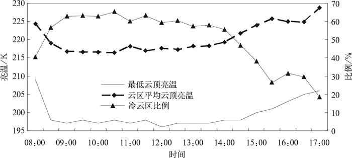
Fig. 6 Temporal variety of minimum and average TBB with ratio of cold center field in cloud
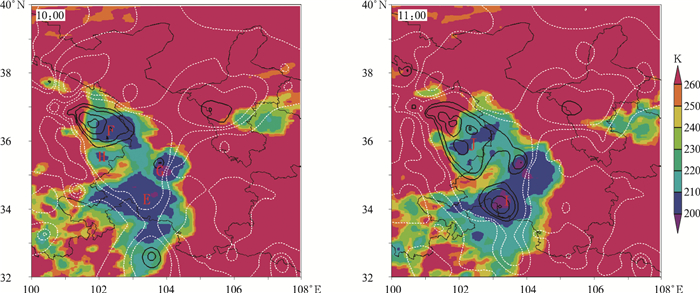
Fig. 7 Satellite image with 24 h surface pressure change at 1000 UTC and 1100 UTC on 7 Aug 2010
(black isolines: 24 h surface pressure change more than 1 hPa; white isolines: 24 h surface pressure change less than-1 hPa)
| [1] |
付丹红, 郭学良.积云合并在强对流系统形成中的作用.大气科学, 2007, 31(4):635-644. http://www.cnki.com.cn/Article/CJFDTOTAL-DQXK200704007.htm
|
| [2] |
甄长忠. 78810冰雹过程的分析.大气科学, 1981, 5(4):456-460. http://www.cnki.com.cn/Article/CJFDTOTAL-DQXK198104012.htm
|
| [3] |
王昂生, 赵小宁, 康玉霞, 等.昔阳地区冰雹云形成过程的一些特征.大气科学, 1980, 4(2):456-460. http://www.cnki.com.cn/Article/CJFDTOTAL-DQXK198002009.htm
|
| [4] |
顾亚进, 党人庆, 唐洵昌, 等.一次MCS过程的卫星云图和数值模拟分析.气象科学, 2002, 22(2):197-204. http://www.cnki.com.cn/Article/CJFDTOTAL-QXKX200202008.htm
|
| [5] |
杨金锡, 陈晓红, 王东勇.1991年7月6—7日黄山特大暴雨分析.气象, 1993, 19(1):39-42. doi: 10.7519/j.issn.1000-0526.1993.01.009
|
| [6] |
王瑾, 蒋建莹, 江吉喜."7·18"济南突发性大暴雨特征.应用气象学报, 2009, 20(3):295-302. doi: 10.11898/1001-7313.20090305
|
| [7] |
李艳伟, 牛生杰, 姚展予, 等.云合并的初始位置探讨.大气科学, 2009, 33(5):1015-1026. http://cdmd.cnki.com.cn/Article/CDMD-10141-1016033574.htm
|
| [8] |
胡雯, 黄勇, 汪腊宝.夏季江淮区域对流云合并的基本特征及影响.高原气象, 2010, 29(1):206-213. http://www.cnki.com.cn/Article/CJFDTOTAL-GYQX201001024.htm
|
| [9] |
黄美元, 徐华英, 吉武胜.积云合并及相互影响的数值模拟研究.中国科学:B辑, 1987, 17(2):214-224. http://www.cnki.com.cn/Article/CJFDTOTAL-JBXK198702012.htm
|
| [10] |
曲晓波, 张涛, 刘鑫华, 等.舟曲"8.8"特大山洪泥石流灾害气象成因分析.气象, 2010, 36(10):102-105. doi: 10.7519/j.issn.1000-0526.2010.10.017
|
| [11] |
钤伟妙, 罗亚丽, 张人禾, 等.引发舟曲特大泥石流灾害强降雨过程成因.应用气象学报, 2011, 22(4):385-397. doi: 10.11898/1001-7313.20110401
|
| [12] |
郑永光, 陈炯, 朱佩君.改进的静止卫星云图软件处理系统.气象, 2007, 33(12):103-109. doi: 10.7519/j.issn.1000-0526.2007.12.016
|
| [13] |
金明星, 张长江.台风云图伪彩色增强的Berkeley小波变换法.计算机应用, 2010, 30(6):1602-1605. http://www.cnki.com.cn/Article/CJFDTOTAL-JSJY201006050.htm
|
| [14] |
李修芳, 范蕙君, 燕芳杰, 等.用增强显示云图确定热带气旋强度的方法.应用气象学报, 1993, 4(3):362-369. http://qikan.camscma.cn/jams/ch/reader/view_abstract.aspx?file_no=19930361&flag=1
|
| [15] |
费增坪, 王洪庆, 张焱, 等.基于静止卫星红外云图的MCS自动识别与追踪.应用气象学报, 2011, 22(4):115-122. http://qikan.camscma.cn/jams/ch/reader/view_abstract.aspx?file_no=20110112&flag=1
|
| [16] |
Morel C, Senesi S.A climatology of mesoscale con-vective systems over Europe using satellite infrared imagery. Ⅰ: Methodology. Q J R Meteorol Soc, 2002, 128:1953-1971. doi: 10.1256/003590002320603485
|
| [17] |
周著华, 白洁, 刘健文, 等, MODIS多光谱云相态识别技术的应用研究.应用气象学报, 2005, 16(5):678-684. doi: 10.11898/1001-7313.20050515
|
| [18] |
周著华, 白洁, 刘健文, 等.基于EOS/MODIS的台风"浣熊"云顶相态分析.气象科学, 2006, 26(5):494-501. http://www.cnki.com.cn/Article/CJFDTOTAL-QXKX200605003.htm
|
| [19] |
Smith R B, Evans J P. Orographic Precipitation and Water Vapor Fractionation over the Southern Andes. J Hydrometeorology, 2007, 8:3-18. doi: 10.1175/JHM555.1
|
| [20] |
Lensky I M, Rosenfeld D. Clouds-aerosols-precipitation satel-lite analysis tool (CAPSAT). Atmos Chem Phys Discuss, 2008, 8(24):6739-6753. http://www.oalib.com/paper/2706409#.WRA4nPl6-0I
|
| [21] |
陈英英, 唐仁茂, 周毓荃, 等.用三通道合成彩色图像进行云的分类解释判读.应用气象学报, 2011, 22(6):691-697. doi: 10.11898/1001-7313.20110606
|
| [22] |
Orville H D, Kuo Y H, Farley R D, et al. Numerical simulation of cloud interactions. J Rech Atmos, 1980, 14:499-516. http://adsabs.harvard.edu/abs/2009AGUFM.A13J0426A
|
| [23] |
Takahashi T, Yamaguchi N, Kawano T. Videosonde observation of torrential rain during Baiu season. J Meteor Soc Japan, 2001, 58(3):205-228. http://www.sciencedirect.com/science/article/pii/S0169809501000837
|

Figures(7)

 DownLoad: