| Citation: | Zhang Tengfei, Yin Liyun, Zhang Jie, et al. Evolutions and cloud-to-ground lightning features of two mesoscale convective thunder storm systems in Yunnan. J Appl Meteor Sci, 2013, 24(2): 207-218.

|
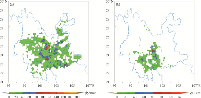
Fig. 1 Cloud-to-ground lightning spatial distribution from 0800 BT 21 Sep to 0800 BT 22 Sep (a) and from 0800 BT 22 Sep to 0800 BT 23 Sep (b) in 2010
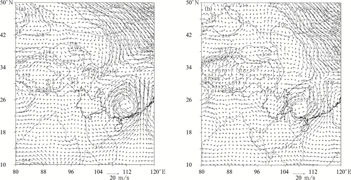
Fig. 2 700 hPa circulation pattern (isoline, unit:gpm) and wind field (vector) at 1400 BT 21 Sep (a) and 1400 BT 22 Sep (b) in 2010
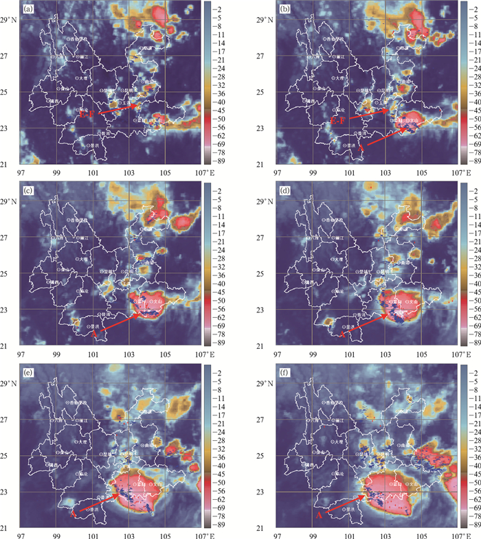
Fig. 3 Satellite infrared cloud image (unit of TBB:℃) stacked with lightning before 30 min for thunderstorm cloud cluster A on 21 Sep 2010 (blue "+" and red "-" represent positive and negative cloud-to-ground lightning, respectively)
(a)1700 BT, (b)1800 BT, (c)1900 BT, (d)2000 BT, (e)2130 BT, (f)2230 BT
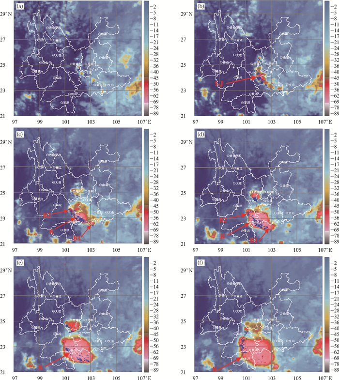
Fig. 4 Satellite infrared cloud image (unit of TBB:℃) stacked with lightning before 30 min for thunderstorm cloud cluster B on 22 Sep 2010 (blue "+" and red "-" represent positive and negative clound-to-ground lightning, respectively)
(a)1600 BT, (b)1730 BT, (c)1930 BT, (d)2030 BT, (e)2130 BT, (f)2230 BT
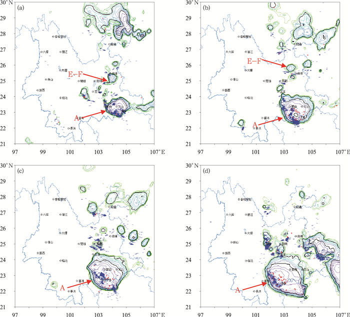
Fig. 5 Distribution of TBB no higher than-20℃(unit:℃; the interval is 4℃; -32℃, -52℃ are thick lines) of thunderstorm cloud cluster A stacked with lightning before 30 min on 21 Sep 2010
(a)1800 BT, (b)2000 BT, (c)2100 BT, (d)2300 BT
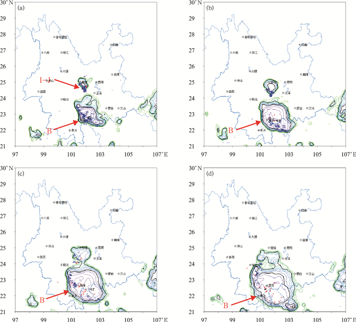
Fig. 6 TBB no higher than-20℃ isoline distribution (unit:℃; the interval is 4℃; -32℃, -52℃ are thick lines) of thunderstorm cloud cluster B stacked with lightning before 30 min on 22 Sep 2010
(blue "+" and red "-" represent positive and negative cloud-to-ground lightning, respectively) (a)2000 BT, (b)2100 BT, (c)2200 BT, (d)2300 BT
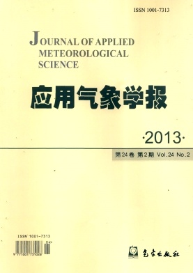
Fig. 7 Time evolution of total, negative and positive cloud-to-ground lightning frequency, and TBB for thunderstorm cloud cluster A (a) and cluster B (b)
| [1] |
张义军, 孟青, 马明, 等.闪电探测技术发展和资料应用.应用气象学报, 2006, 17(5):611-620. doi: 10.11898/1001-7313.20060504
|
| [2] |
张腾飞, 段旭, 张杰, 等.云南强对流暴雨的闪电和雷达回波特征及相关性.热带气象学报, 2010, 27(3):379-386. http://www.cnki.com.cn/Article/CJFDTOTAL-RDQX201103011.htm
|
| [3] |
张腾飞, 张杰, 郭荣芬.一条中尺度雨带的多普勒雷达回波特征及环境条件分析.应用气象学报, 2005, 16(1):70-77. doi: 10.11898/1001-7313.20050109
|
| [4] |
Rutledge S A, Lu C, MacGorman D R. Positive cloud-to-ground lightning in mesoscale convective system.J Atmos Sci, 1990, 47:1085-2100. http://adsabs.harvard.edu/abs/1990JAtS...47.2085R
|
| [5] |
Holle R L, Watson A L, Lopez R E, et a1.The life cycle of lightning and severe weather in a 3—4 June 1985 PRE-STORM mesoseale convective system.Mon Wea Rev, 1994, l22:1798-1808. http://adsabs.harvard.edu/abs/1994MWRv..122.1798H
|
| [6] |
Qie Xiushu, Yan Muhong, Guo Changming, et a1.Lightningdata and study of thunderstorm noweasting.Acta Meteor Sinica, 1993, 7:244-256. http://www.cnki.com.cn/Article/CJFDTotal-QXXW199302012.htm
|
| [7] |
蒙伟光, 易燕明, 杨兆礼, 等.广州地区雷暴过程云-地闪特征及其环境条件.应用气象学报, 2008, 19(5):611-619. doi: 10.11898/1001-7313.20080513
|
| [8] |
袁铁, 郄秀书.基于TRMM卫星对一次华南飑线的闪电活动及其与降水结构的关系研究.大气科学, 2010, 34(1):58-70. http://www.cnki.com.cn/Article/CJFDTOTAL-DQXK201001006.htm
|
| [9] |
冯桂力, 郄秀书, 袁铁, 等.一次冷涡天气系统中雹暴过程的地闪特征分析.气象学报, 2006, 64(2):211-220. doi: 10.11676/qxxb2006.021
|
| [10] |
刘冬霞, 郄秀书, 冯桂力.华北一次中尺度对流系统中的闪电活动特征及其与雷暴动力过程的关系研究.大气科学, 2010, 34(1):95-104. http://www.cnki.com.cn/Article/CJFDTOTAL-DQXK201001009.htm
|
| [11] |
冯桂力, 郄秀书, 周筠珺.一次中尺度对流系统的闪电演变特征.高原气象, 2006, 25(2):220-228. http://www.cnki.com.cn/Article/CJFDTOTAL-GYQX200602006.htm
|
| [12] |
郑栋, 孟青, 吕伟涛, 等.北京及其周边地区夏季地闪活动时空特征分析.应用气象学报, 2005, 16(5):638-644. doi: 10.11898/1001-7313.20050510
|
| [13] |
郄秀书, Ralf Toumi.卫星观测到的青藏高原雷电活动特征.高原气象, 2003, 22(3):288-294. http://www.cnki.com.cn/Article/CJFDTOTAL-GYQX200303013.htm
|
| [14] |
戴建华, 秦虹, 郑杰.用TRMM/LIS资料分析长江三角洲地区的闪电活动.应用气象学报, 2005, 16(6):728-736. doi: 10.11898/1001-7313.20050613
|
| [15] |
王艳, 张义军, 马明.卫星观测的我国近海海域闪电分布特征.应用气象学报, 2010, 21(2):157-163. doi: 10.11898/1001-7313.20100204
|
| [16] |
张腾飞, 许迎杰, 张杰, 等.云南雷电活动的大气相对湿度诊断特征及响应关系分析.应用气象学报, 2010, 21(2):180-188. doi: 10.11898/1001-7313.20100207
|
| [17] |
陈渭明.雷电学原理.北京:气象出版社, 2006:79-144.
|
| [18] |
张义军, 葛正谟, 陈成品, 等.青藏高原东部地区的大气电特征.高原气象, 1998, 17(2):135-141. http://www.cnki.com.cn/Article/CJFDTOTAL-GYQX802.003.htm
|
| [19] |
Fuquay D M.Positive cloud-to-ground lightning in summer thunderstorm.J Geophys Res, 1982, 87:7131-7140. doi: 10.1029/JC087iC09p07131
|
| [20] |
Carey L D, Murphy M J, McCormick T L, et al.Lightning location relative to storm structure in a leading-line, trailing-stratiform mesoscale convective system EJ3.J Geophys Res, 2005, 110:D03105, doi: 10.1029/2003JD004371.
|
| [21] |
Jacobon E A, Krider E P.Electrostatic field changes produced by Florida lightning.J Atmos Sci, 1976, 33:103-117. doi: 10.1175/1520-0469(1976)033<0103:EFCPBF>2.0.CO;2
|

Figures(7)

 DownLoad: