Lu Xiaoqin, Lei Xiaotu, Yu Hui, et al. An objective TC intensity estimation method based on satellite data. J Appl Meteor Sci, 2014, 25(1): 52-58.
Citation: Lu Xiaoqin, Lei Xiaotu, Yu Hui, et al. An objective TC intensity estimation method based on satellite data. J Appl Meteor Sci, 2014, 25(1): 52-58.

An Objective TC Intensity Estimation Method Based on Satellite Data

  • Received Date: 2013-04-24
  • Rev Recd Date: 2013-09-23
  • Publish Date: 2014-01-31
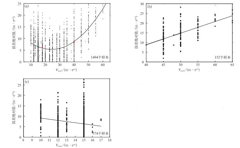
  • Researches prove that TC (tropical cyclone) intensity is mainly determined by the top cloud convection strength, distribution and size. Then how to extract this information from TC cloud image is very important for TC intensity estimation. In 1988, Adler put forward a method named CST (convective-stratiform technique) to extract tropical convective cores from TC cloud image. Using MTSAT (multi-functional transport satellite) IR1 black body temperature data, the TC cloud top strong convection is extracted. Based on the convective cores number, convective core distance to TC center and convective core black body temperature extreme value, which are closely related to TC intensity, a TC intensity (expressed by Vmax, the maximum sustained wind speed near surface TC center) estimation model is put forward using stepwise regress method. The experiment result shows that there is a linear correlation between their estimation error and their intensity for Vmax >40 m·s-1 and Vmax < 18 m·s-1 samples. So according to the estimation error distribution a linear revision is carried out.Statistical tests show this model is equivalent to Dvorak method and AMSU in TC intensity estimation accuracy. It's also reliable based on the relationship between the convective cores, convective cores distribution, brightness temperature and TC intensity. It could be used in all TC life span automatically and objectively, so it could be applied in the operation.Comparing with the advanced objective dvorak technique (AODT) and objective Dvorak technique (ODT), this algorithm gives accurate results in the Western North Pacific, but it's simpler with no complicated pattern types identifying process or other rules. A fixed radius of 135 km area is used as TC convective cores searching effective area in the model, but actually the maximum wind speed radius of the TC is variable, the TC size and the strongest convective area size are different for different TC in different stage. So using the fixed searching area may affect TC intensity estimation accuracy. The research on how to get the dynamical maximum wind speed radius would be carried out in the future.
  • Fig. 1  The relation between tropical cyclone intensity and the absolute errors of tropical cyclone intensity estimation

    (a) all samples, (b)Vmax>40 m·s-1, (c)Vmax < 18 m·s-1

    Table  1  Correlation coefficients between convective core information and tropical cyclone intensity in different areas

    对流核因子 100 km 135 km 200 km 300 km 400 km 500 km
    CLON 0.074 0.053 0.051 0.046 0.043 0.041
    CLAT 0.144 0.128 0.113 0.098 0.091 0.085
    Dmin -0.095 -0.111 -0.133 -0.144 -0.133 -0.139
    Dmax 0.244 0.191 0.178 0.110 0.051 0.019
    Tmin -0.241 -0.197 -0.172 -0.141 -0.123 -0.119
    Tmax -0.433 -0.488 -0.468 -0.352 -0.222 -0.106
    N 0.483 0.535 0.533 0.493 0.436 0.374
    Tmean -0.017 -0.334 -0.303 -0.243 -0.210 0.201
    Dmean 0.047 -0.015 -0.146 -0.210 -0.227 -0.264
    Tdif -0.053 -0.268 -0.132 0.000 0.056 0.091
    Tindex -0.271 -0.471 -0.456 -0.361 -0.282 -0.232
    Dindex 0.147 0.143 0.055 -0.023 -0.076 -0.115
    DownLoad: Download CSV

    Table  2  Tropical cyclone intensity estimation errors

    统计量 非独立样本 独立样本
    平均绝对误差/(m·s-1) 7.3 7.4
    均方根误差/(m·s-1) 9.2 9.6
    DownLoad: Download CSV

    Table  3  The maximum sustained wind speed estimation errors in different intensity groups

    样本类型 热带气旋强度分级 样本量 平均绝对误差/(m·s-1) 均方根误差/(m·s-1)
    独立样本 热带低压 91 7.2 9.2
    热带风暴 118 5.7 7.3
    强热带风暴 76 5.3 6.4
    台风 72 5.7 7.0
    强台风 29 15.0 16.0
    超强台风 20 21.7 22.7
    非独立样本 热带低压 574 7.0 8.7
    热带风暴 308 5.1 6.7
    强热带风暴 209 5.7 6.8
    台风 250 7.6 9.3
    强台风 115 13.3 14.5
    超强台风 37 18.6 19.3
    DownLoad: Download CSV

    Table  4  The modified tropical cyclone intensity estimation errors

    统计量 非独立样本 独立样本
    平均绝对误差/(m·s-1) 5.5 5.9
    均方根误差/(m·s-1) 6.9 7.7
    DownLoad: Download CSV
  • [1]
    Dvorak V F, Smigielski F. 卫星观测的热带云和云系. 郭炜, 卢乃锰, 译. 北京: 气象出版社, 1996: 183-189.
    [2]
    Dvorak V F.Tropical cyclone intensity analysis and forecasting from satellite imagery. Mon Wea Rev, 1975, 103:420-430. doi:  10.1175/1520-0493(1975)103<0420:TCIAAF>2.0.CO;2
    [3]
    Dvorak V F.Tropical Cyclone Intensity Analysis Using Satellite Data.NOAA Tech Rep NESDIS 11, 1984:47. http://www.worldcat.org/title/tropical-cyclone-intensity-analysis-using-satellite-data/oclc/11504016
    [4]
    Engel G T.Satellite Applications at the Joint Typhoon Warning Center.Tech Doc WMO/TD, 5th WMO International Workshop on Tropical Cyclones, 2002:1136.
    [5]
    Velden C S, Olander T L, Zehr R M.Development of an objective scheme to estimate tropical cyclone intensity from digital geostationary satellite infrared imagery. Wea Forecasting, 1998, 13:172-186. doi:  10.1175/1520-0434(1998)013<0172:DOAOST>2.0.CO;2
    [6]
    Olander T L, Velden C S.The advanced Dvorak technique:Continued development of an objective scheme to estimate tropical cyclone intensity using geostationary infrared satellite imagery. Wea Forecasting, 2007, 22:287-298. doi:  10.1175/WAF975.1
    [7]
    Kossin J P, Velden C S.A pronounced bias in tropical cyclone minimum sea level pressure estimation based on the Dvorak technique. Mon Wea Rev, 2004, 132:165-173. doi:  10.1175/1520-0493(2004)132<0165:APBITC>2.0.CO;2
    [8]
    Kidder S Q, Goldberg M D, Zehr R M, et al.Satellite analysis of tropical cyclones using the Advanced Microwave Sounding Unit (AMSU). Bull Amer Meteor Soc, 2000, 81:1241-1259. doi:  10.1175/1520-0477(2000)081<1241:SAOTCU>2.3.CO;2
    [9]
    Bankert R L, Tag P M.An automated method to estimate tropical cyclone intensity using SSM/I imagery. J Appl Meteor, 2002, 41:461-472. doi:  10.1175/1520-0450(2002)041<0461:AAMTET>2.0.CO;2
    [10]
    Yu H, Chan C L, Duan Y H.Intensity estimation of tropical cyclones over the Western North Pacific with AMSU-A temperature data. J Meteor Soc Japan, 2006, 84(3):519-527. doi:  10.2151/jmsj.84.519
    [11]
    王瑾, 江吉喜.热带气旋强度的卫星探测客观估计方法研究.应用气象学报, 2005, 16(3):283-292. doi:  10.11898/1001-7313.20050302
    [12]
    杨祖芳, 李伟华.一种运用云顶亮温确定热带气旋海面大风区的方法.热带气象学报, 1999, 15(1):71-75. http://cpfd.cnki.com.cn/Article/CPFDTOTAL-ZGHJ200007001008.htm
    [13]
    陈佩燕, 端义宏, 余晖, 等.红外云顶亮温在西北太平洋热带气旋强度预报中的应用.气象学报, 2006, 64(4):474-484. doi:  10.11676/qxxb2006.047
    [14]
    Gentry R C, Rodgers E, Steranka J, et al.Predicting tropical cyclone intensity using satellite measured equivalent blackbody temperatures of cloud tops. Mon Wea Rev, 1980, 108(4):445-455. doi:  10.1175/1520-0493(1980)108<0445:PTCIUS>2.0.CO;2
    [15]
    方宗义, 周连翔.用地球同步气象卫星红外云图估计热带气旋的强度.气象学报, 1980, 38(2):150-159. doi:  10.11676/qxxb1980.018
    [16]
    李修芳, 范慧君, 燕芳杰, 等.用增强显示云图确定热带气旋强度的方法.应用气象学报, 1993, 4(3):362-368. http://qikan.camscma.cn/jams/ch/reader/view_abstract.aspx?file_no=19930361&flag=1
    [17]
    李俊.气象卫星台风云图的自动识别与应用.应用气象学报, 1992, 3(4):402-409. http://qikan.camscma.cn/jams/ch/reader/view_abstract.aspx?file_no=19920467&flag=1
    [18]
    师春香, 吴蓉璋, 项续康.多阑值和神经网络卫星云图云系自动分割试验.应用气象学报, 2001, 12(1):70-78. http://qikan.camscma.cn/jams/ch/reader/view_abstract.aspx?file_no=20010108&flag=1
    [19]
    Rao P K, Holmes S J, Andason R K, et al. 气象卫星: 系统, 资料及其在环境中的应用. 许建民, 方宗义, 徐建平, 等译. 北京: 气象出版社, 1994: 230-240.
    [20]
    刘喆, 韩志刚, 赵增亮, 等.利用ATOVS反演产品分析"云娜"台风.应用气象学报, 2006, 17(4):473-477. doi:  10.11898/1001-7313.20060413
    [21]
    许健民, 张其松.卫星风推导和应用综述.应用气象学报, 2006, 17(5):574-582. doi:  10.11898/1001-7313.20060515
    [22]
    Adler R F, Negri A J.A satellite infrared technique to estimate tropical convective and stratiformrainfall. J Appl Meteor, 1988, 27:31-51. https://www.researchgate.net/publication/23603098_A_Satellite_Infrared_Technique_to_Estimate_Tropical_Convective_and_Stratiform_Rainfall
    [23]
    Knaff J A, Brown D P, Courtney J, et al.Anevaluation of Dvorak technique-based tropical cyclone intensity estimates. Wea Forecasting, 2010, 25:1362-1379. doi:  10.1175/2010WAF2222375.1
  • 加载中
  • -->

Catalog

    Figures(1)  / Tables(4)

    Article views (2490) PDF downloads(898) Cited by()
    • Received : 2013-04-24
    • Accepted : 2013-09-23
    • Published : 2014-01-31

    /

    DownLoad:  Full-Size Img  PowerPoint