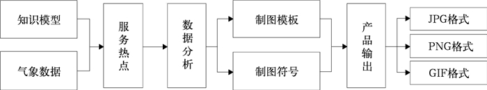
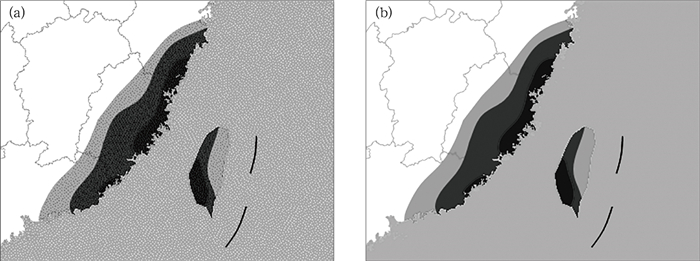
Zhang Zhentao, Zhang Zhengwen, Chen Yu, et al. An event-based public meteorological service product system. J Appl Meteor Sci, 2014, 25(2): 249-256.
Citation: Zhang Zhentao, Zhang Zhengwen, Chen Yu, et al. An event-based public meteorological service product system. J Appl Meteor Sci, 2014, 25(2): 249-256.

An Event-based Public Meteorological Service Product System

  • Received Date: 2013-07-08
  • Rev Recd Date: 2013-12-13
  • Publish Date: 2014-03-31
  • The rapid developments of the new media technology and the expansion of dissemination channels have brought higher requirements in timeliness and aesthetic property in the processes of making meteorological service products. The present meteorological working platform mostly relies on the third-party GIS component to complete the analysis of meteorological data and the output of products. Through the analysis on difficulties in making public meteorological service products, a manufacture framework based on weather events is proposed. The framework is oriented towards meteorological knowledge extraction, data analysis, geographical boundaries clipping and graphics quality control and so on.The key issues of the framework are focused on four procedures, including identified service hotspot, meteorological data analysis, applying product template and product output. The fundamental of service and product determination is to determine service hotspots, so knowledge modeling association between hotspots and products is linked. While meteorological data analysis is the bridge between data and products, the triangle-grid interpolation algorithm and rectangle-grid isoline tracking algorithm are integrated in analyzing observations and numerical forecast results. Applying product templates is based on the control of information area, the clip property of GDI+ helps exclude invalid information to ensure using the correct templates, and to highlight the key information of the product. Meanwhile, product output is often faced with a variety of distribution media, so the Octree algorithm is applied to quantize the product color when the file size is limited to a small value, and the products can be used through more media.C# language is used in programming the event-based public meteorological service product prototype system, which is called MonaRudo. MonaRudo is a lightweight system which adopts 1:4000000 GIS vector data, including hotspot verifying of meteorological service, interaction tools library, file browsing modules and so on. The interaction tools library, algorithms library and other libraries are all loaded as plugins. MonaRudo focuses on the flexibility of user interaction as well as an integrated scripting language named MonaScript which is provided for unattended products manufacture.Since 2012, MonaRudo has been used in typhoon meteorological service and "golden week" meteorological service, providing more than 20 kinds of service products. Because of the complete structure and powerful functionality, MonaRudo has brought good service results for Web sites and mobile phones.
  • Fig. 1  The expert system shell

    Fig. 2  Production process of meteorological products

    Fig. 3  Comparison chart of image quantization algorithm (a) before Octree quantified, (b) after Octree quantified

    Fig. 4  System structure of public meteorological service products

    Fig. 5  MonaRudo software interface

    Fig. 6  Meteorological service products of mobile newspaper

    Table  1  Contact chart of meteorological concepts and meteorological products

    1级目录 2级目录 产品样式 后台数据
    暴雨 ① 降水情况——24 h累积降水量、实况暴雨区
    ② 暴雨过程——逐小时降水累加动态
    ③ 极值情况——突破极值城市排行
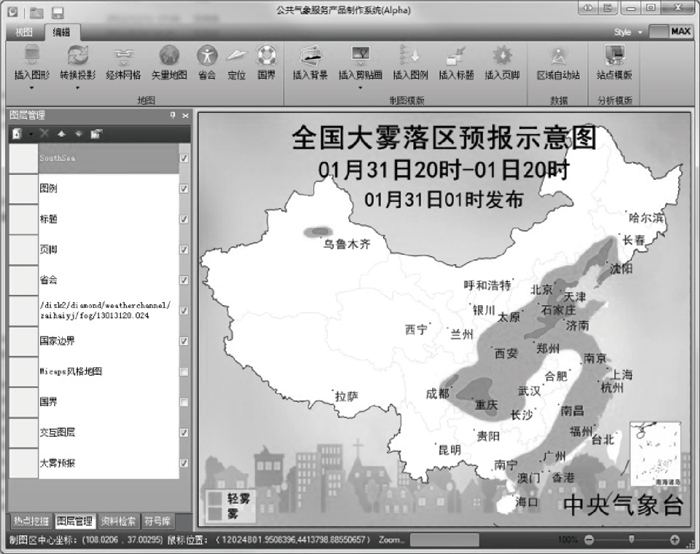
    ① 预警情况
    ② 满足某阈值 (日降水量超过50 mm,100 mm,250 mm等) 的降水量实况排行 (34个省会级城市)
    ③ 单站当年第1场暴雨实况和预报
    ④ 单站截至某时间的当年最大一场降雨
    ⑤ 暴雨实况区的色域填图
    ⑥ 暴雨实况累加动态图
    ⑦ 降水突破极值情况
    ⑧ 雷达动态示意
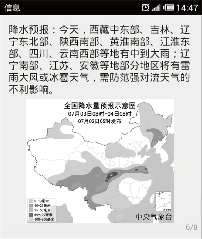
    ① 中央气象台预警
    ② 预警服务提示
    ③ 过去6 h,12 h,24 h降水量实况
    ④ 地面观测实况数据
    ⑤ 1~3 d降水量暴雨预报
    ⑥ 历史降水资料
    ⑦ 10 min雷达图
    旅游天气 (端午节、高考等) ① 适宜出行——温度满足某阈值,降水量低于某阈值
    ② 不适宜出行——温度情况、降水情况、强风天气
    ③ 有无灾害性天气预警
    ④ 根据旅游特色作旅游推荐
    ① 未来1~3 d,1~7 d的无降水区域叠加图
    ② 未来1~3 d,1~7 d的满足某阈值的最高、最低气温色域填图
    ③ 未来1~3 d,1~7 d的大雨以上量级的叠加图
    ④ 未来1~3 d,1~7 d的大雨以上量级的叠加图
    ⑤ 未来1~3 d,1~7 d的大风以上量级的叠加图
    ⑥ 未来1~3 d,1~7 d的降温幅度超过某阈值的叠加图
    ⑦ 灾害预警的色域综合图
    ⑧ 未来1~5 d的12 h,24 h天空云量色域填图
    ⑨ 满足某温度阈值、某降水阈值、某风力阈值的综合色域填图
    ① 未来1~3 d短期天气预报
    ② 中期天气预报
    ③ 各类灾害性天气预警
    ④ 1~5 d城市天气预报 (最高气温、最低气温、风力、降水等)
    农事服务 (夏收夏种) ① 农作物生产情况
    ② 影响农业的灾害性天气
    ③ 高温、持续阴雨
    ④ 寒露风
    ⑤ 霜冻
    ① 霜冻预报区域图
    ② 寒露风的预报区域图
    ③ 霜冻实况区域图
    ④ 寒露风的实况区域图
    ⑤ 满足某阈值 (突破35℃,40℃等) 的最高气温预报色域填图
    ⑥ 满足某阈值的温度实况色域填图
    ⑦ 连续低温阴雨的实况色域填图
    ⑧ 大风区域实况、预报图
    ① 未来1~5 d最高气温、最低气温预报
    ② 过去6 h,12 h,24 h降水量实况
    ③ 地面观测实况数据
    ④ 农作物生产情况
    ⑤ 逐小时大风实况
    DownLoad: Download CSV
  • [1]
    李月安, 曹莉, 高嵩, 等.MICAPS预报业务平台现状与发展.气象, 2010, 36(7):50-55. doi:  10.7519/j.issn.1000-0526.2010.07.010
    [2]
    吴焕萍, 罗兵, 王维国, 等.GIS技术在决策气象服务建设系统中的运用.应用气象学报, 2008, 19(3):380-384. doi:  10.11898/1001-7313.20080316
    [3]
    唐卫, 吴焕萍, 罗兵, 等.基于GIS的气象服务产品后台制作系统.计算机工程, 2009, 35(17): 232-234. doi:  10.3969/j.issn.1000-3428.2009.17.080
    [4]
    何险峰, 马力, 罗永康, 等.近实时公共气象服务分析图网站发布.气象科技, 2012, 40(4):578-584. http://www.cnki.com.cn/Article/CJFDTOTAL-QXKJ201204013.htm
    [5]
    李德泉, 周勇, 虞海燕.北京奥运气象服务产品制作系统设计与实现.应用气象学报, 2010, 21(3):372-378. doi:  10.11898/1001-7313.20100314
    [6]
    Ding L, Medvidovic N.Focus:A Light-weight, Incremental Approach to Software Architecture Recovery and Evolution.Proceedings, Working IEEE/IFIP Conference on IEEE, 2001:191-200.
    [7]
    何险峰, 郑丽娟, 徐箐, 等.GIS在公共气象服务网站中的应用.计算机应用与软件, 2012, 29(2):227-230. http://www.cnki.com.cn/Article/CJFDTOTAL-JYRJ201202068.htm
    [8]
    Bally J, Boneh T, Nicholson A E, et al.Developing an Ontology for the Meteorological Forecasting Process.Proceedings of the 2004 IFIP International Conference on Decision Support Systems (DSS2004).2004.
    [9]
    史忠植.知识工程.北京:清华大学出版社, 1988.
    [10]
    李庆祥, 黄嘉佑.对我国极端高温事件阈值的探讨.应用气象学报, 2011, 22(2):138-143. doi:  10.11898/1001-7313.20110202
    [11]
    龚志强, 王晓娟, 崔冬林, 等.区域性极端低温事件的识别及其变化特征.应用气象学报, 2012, 23(2):195-204. doi:  10.11898/1001-7313.20120208
    [12]
    Lee C S, Jian Z W, Huang L K.A fuzzy ontology and its application to news summarization.IEEE Transactions, 2005, 35(5):859-880. https://www.researchgate.net/publication/7525344_A_Fuzzy_Ontology_and_Its_Application_to_News_Summarization
    [13]
    Abraham A.Rule-Based Expert Systems.Handbook of Measuring System Design, 2005.
    [14]
    Brian G, Tim P, Joshua B, et al.Java Concurrency in Practice.Boston:Addison-Wesley Professional, 2006.
    [15]
    Lakshman A, Malik P.Cassandra:A decentralized structured storage system.ACM SIGOPS Operating Systems Review, 2010, 44(2):35-40. doi:  10.1145/1773912
    [16]
    Studer R, Benjamins V R, Fensel D.Knowledge engineering:Principles and methods.Data & Knowledge Engineering, 1998, 25(1):161-197. http://citeseerx.ist.psu.edu/viewdoc/summary?doi=10.1.1.41.1007
    [17]
    郑盛贵, 颜七笙, 黄临平.基于点的三角形构网算法及等值线自动生成方法.计算机与现代化, 2004, 5:7-9. doi:  10.3969/j.issn.1006-2475.2004.05.003
    [18]
    蒋瑜, 杜斌, 卢军, 等.基于Delaunay三角网的等值线绘制算法.计算机应用研究, 2010, 27(1): 101-103. http://www.cnki.com.cn/Article/CJFDTOTAL-JSYJ201001032.htm
    [19]
    刘青, 钱玮.一种八叉树量化算法的改进.电子技术, 2010, 47(8):1-3. http://www.cnki.com.cn/Article/CJFDTOTAL-DZJS201008000.htm
    [20]
    庄立伟, 卫建国, 毛留喜.软件设计模式在农业气象系统开发中的应用.应用气象学报, 2011, 22(5):631-640. doi:  10.11898/1001-7313.20110514
    [21]
    刘品高, 江南, 谭萍, 等.气象地理信息系统的设计与实现.应用气象学报, 2005, 16(4):547-553. doi:  10.11898/1001-7313.20050416
  • 加载中
  • -->

Catalog

    Figures(6)  / Tables(1)

    Article views (2589) PDF downloads(1407) Cited by()
    • Received : 2013-07-08
    • Accepted : 2013-12-13
    • Published : 2014-03-31

    /

    DownLoad:  Full-Size Img  PowerPoint